 | 02 Dec 2019
The Bouse Formation, a controversial Neogene archive of the evolving Colorado River: a scientific drilling workshop report (28 February–3 March 2019 – BlueWater Resort & Casino, Parker, AZ, USA)
Colleen Cassidy
Ryan Crow
Jordon Bright
Laura Crossey
Rebecca Dorsey
Brian Gootee
Kyle House
Keith Howard
Karl Karlstrom
Philip Pearthree
Neogene deposits of the lower Colorado River valley, especially the Miocene(?) and early Pliocene Bouse Formation, have been the focus of intense debate regarding the early paleoenvironmental history of this important continental-scale river system in southwestern North America and its integration with the proto-Gulf of California. Fine-grained units within these Neogene deposits also hold a promising archive of Pliocene paleoclimate history for this part of the world. Because the depocenter deposits of the Bouse Formation and the deposits that overlie and underlie it are poorly exposed and highly weathered, the formation is ripe for study through collection of drill cores. A workshop was held 28 February–3 March 2019 in Parker, AZ, USA, to discuss how scientific drilling might be employed to help resolve the Bouse controversies and improve our understanding of paleoclimate history in the region.
- Article
(7018 KB) - Full-text XML
- BibTeX
- EndNote


The Colorado River (CR) is one of the longest rivers of North America (2330 km), with a watershed spanning 640 000 km2 of eight US and Mexican states, making it a critical resource for the arid southwestern part of the continent. This dynamic modern river is imperiled today by overutilization of its water resource and a changing climate. Just as the river system today presents a rapidly unfolding story of environmental change, its past geological history along with the basins receiving its water and sediment present scientists with critical lessons for understanding possible future change.
A key archive of this past history can be found in the late Miocene(?) and early Pliocene Bouse Formation, which crops out and is present in the subsurface along the lower CR valley of western Arizona, southern Nevada, and southeastern California today (Figs. 1, 2) (Metzger, 1968; Buising, 1990; House et al., 2008). The Bouse Formation, which can range from less than 10 m thick in some outcrop exposures to over 250 m in subsurface wells, contains the depositional record of a number of large water bodies, and the scientific investigation of this unit has a legacy of controversy that continues to today. The largest of these water bodies, which occupied the Blythe basin and adjacent areas, covered over 10 000 km2 (Spencer et al., 2013), almost twice the size of the modern Great Salt Lake (Utah). For decades, geologists, paleontologists, and geochemists have been embroiled in a scientific debate as to the paleoenvironmental nature and age of these water bodies (e.g., Buising, 1990; Spencer and Patchett, 1997; McDougall, 2008; Spencer et al., 2008, 2013; McDougall and Miranda Martínez, 2014; Gootee et al., 2016; O'Connell et al., 2017; Bright et al., 2018a, b; Dorsey et al., 2018) and the implications of these variable interpretations for the history of the CR, the integration of the river into the evolving Gulf of California, and regional tectonic history, including both the southern basin and range region and the Colorado Plateau (e.g., Bennett et al., 2016; Karlstrom et al., 2017; Pearthree and House, 2014; Crow et al., 2019a).
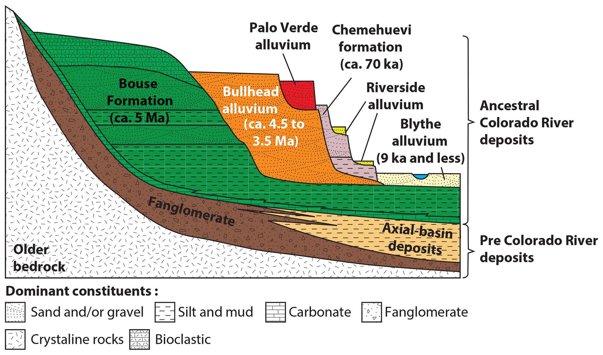
Figure 1Simplified stratigraphic and geomorphic relationships of Neogene formations exposed in the lower Colorado River basin (after Buising, 1990; Howard et al., 2015; Crow et al., 2019a). Ages for the Palo Verde alluvium (Late Pleistocene; Lundstrom et al., 2008) and the Riverside alluvium (Early(?) or Middle Pleistocene; House et al., 2018) are poorly constrained.

Figure 2Geological index maps of (a) the Blythe basin study area and (b) the regional setting of the Blythe basin with respect to geologic elements of the Colorado River corridor and the Gulf of California, showing the reconstructed outlines of paleo-water bodies for the Bouse deposystem in darker gray and basin spillover locations with black lines. Panel (a) shows the outcrop distribution of stratigraphic units discussed in the text (modified from Crow et al., 2018), locations of prior water/geotechnical wells with cuttings/log records available for this study and cross sections illustrated in Fig. 4. Most discussion on target localities for drilling have focused on the well exposed and controversial Bouse Formation rocks of the Blythe basin. Potential and promising drill sites were also examined in the Yuma basin, south of the Chocolate Mountains basinal divide. Provisional drilling target areas are shown but additional site survey work is required prior to final site selections.
The most intense debate has focused on the origin of the basal Bouse Formation and exposures in the Blythe basin. This unit has variably been interpreted as having formed in marine (initially unaffected by CR water, but later estuarine) (Buising, 1990; McDougall and Miranda Martínez, 2014; Dorsey et al., 2018; Crossey et al., 2015) or lacustrine (Spencer and Patchett, 1997; Roskowski et al., 2010; Bright et al., 2016, 2018a, b) conditions, or in some hybrid of these scenarios evolving over time, based on conflicting evidence from fossils, isotope geochemistry, and sedimentology (Fig. 3). The fossil record of the lower Bouse Formation includes a bewildering mixture of apparently marine or estuarine (e.g., planktic foraminiferans, barnacles, and Thalassinoides trace fossils) and lacustrine (ostracodes, Chara, molluscs) fossils (Bright et al., 2018b). Sigmoidal bedding and other depositional features interpreted to be of marine tidal origin (O'Connell et al., 2017) were also interpreted by Spencer et al. (2018) to indicate a lacustrine origin. Isotopic data (C, O, and Sr) from Bouse carbonates uniformly point towards a continental water source, either similar to or modified from CR water, with little indication of a marine influence (Spencer and Patchett, 1997; Bright et al., 2016, 2018a, b). Two broad classes of models have arisen from these interpretations of the Blythe basin deposits, an incursion (or multiple incursions) of marine waters from an evolving proto-Gulf of California (McDougall and Miranda Martínez, 2014; Dorsey et al., 2018) or a “fill and spill” scenario of CR waters making their way downstream below the Grand Canyon by infilling a series of pre-existing basins as large lakes, which eventually infill with sediment and overtop their sill thresholds, allowing the CR to extend its length downstream towards an ultimate interconnection with the gulf (House et al., 2008; Spencer et al., 2013). Most participants in this debate now agree that Bouse Formation deposits in basins upstream from the Blythe basin, while displaying grossly similar stratigraphies and geochemical signatures to that basin, were all fully lacustrine through their history. Thus, it is only the Blythe basin that is currently at the core of this controversy.
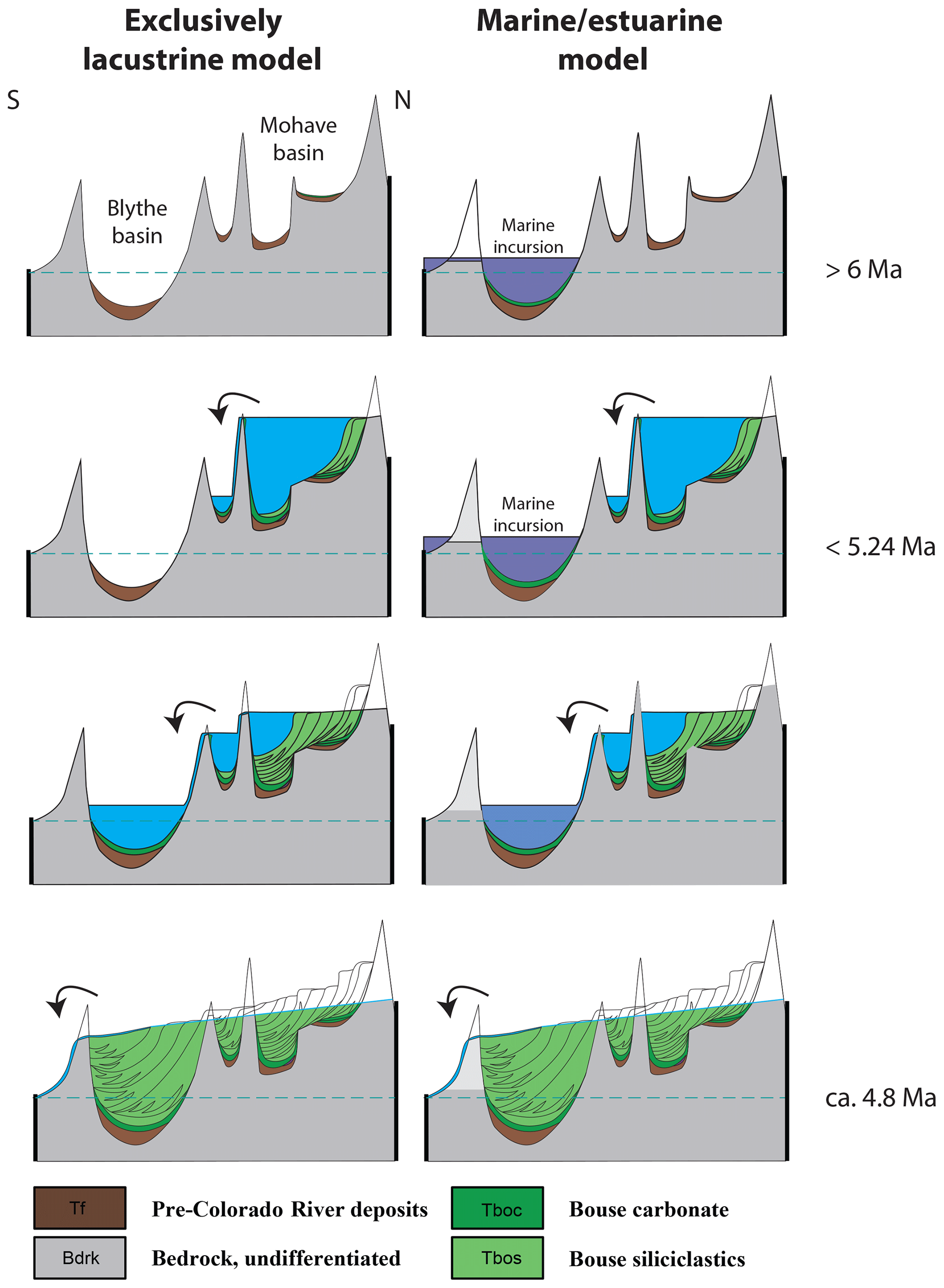
Figure 3Alternative paleoenvironmental models for the Bouse Formation (after Pearthree and House, 2014). In the exclusively lacustrine model (Spencer and Patchett, 1997; House et al., 2008; Roskowski et al., 2010; Spencer et al., 2013; Bright et al., 2016, 2018a, b) the precursor internally drained Miocene basins and fanglomerate and playa deposits (brown) of the future lower Colorado River valley were successively flooded by a series of overspilling lakes, initially depositing the transgressive tufa, marl, and shelly carbonates of the lower Bouse Formation (dark green). Upstream basins were rapidly infilled by the progradational sediment bodies of the early Pliocene, upper siliciclastic Bouse (light green) (and later, Bullhead Alluvium), which eventually integrated the evolving Colorado River system into the proto-Gulf of California in the early Pliocene. Subsequent downcutting of the system resulted in the graded deposystem that has evolved since the early Pliocene. In the marine/estuarine model (Buising, 1990; McDougall and Miranda Martínez, 2014; Dorsey et al., 2018), arrival of the prograding Colorado River system into the Blythe basin was preceded in the late Miocene by a marine incursion, resulting in the formation of marine or estuarine bioclastic carbonates of the lower Bouse through one or more transgressive events. Subsequent arrival of the prograding and then downcutting Colorado River system then transformed the deposystem in a manner similar to the lacustrine model.
In addition to this enigmatic history, the Bouse Formation, as well as the alluvial deposits that overlie it (e.g., Bullhead Alluvium, Howard et al., 2015; Chemehuevi Formation, Malmon et al., 2011; and Blythe Alluvium, Block et al., 2019; Fig. 1), house an outstanding and largely still untapped record of the history of both the CR since the Pliocene and climatic conditions during the early Pliocene. The latter is of particular significance, as this time period represents an initial episode of warming (e.g., Drury et al., 2018) towards the Piacenzian (mid-Pliocene warm period), which may be analogous to our modern anthropogenically driven transition to a warmer planet. Understanding the history of the CR, a critical water resource for desert southwestern North America, through its downstream Bouse Formation paleorecords is thus of value for society as a whole.
It was through this lens of multiple lines of scientific interest in the Bouse Formation that a workshop was held 28 February–3 March 2019 in Parker, AZ, USA, to discuss the possibility of developing a scientific drilling project targeting this formation and its overlying CR-related strata. Over the course of 4 d, 33 participants debated whether, where, and how a drilling and coring campaign might proceed that could address (and perhaps resolve) the fundamental controversies surrounding the origin of the Bouse Formation in the Blythe basin and how high-resolution drill core records might improve our understanding of the paleoclimate and paleohydrology of this region.
The workshop opened with a series of background talks intended to lay out our current understanding of the Bouse Formation, its tectonic setting, stratigraphy and sedimentology, paleontology, age, and geochemistry. Karl Karlstrom and Jacob Thacker (University of New Mexico) and Vicki Langenheim (USGS) discussed our current understanding from isostatic modeling of syn- and post-Bouse deformation, structural mapping, and geophysical surveys. Isostatic modeling is useful for estimating the original vertical position of key features related to the Bouse Formation, such as shorelines. Understanding the depth and shape of the Bouse depocenters (particularly those lying below sea level today) and their deformation history is critical for decision-making on appropriate drilling targets based on variable predictions of the marine incursion versus lake-fill and spill models. Understanding Bouse basinal strain history from outcrop fault geometries is key to understanding how tectonics has influenced lower CR deposits before, during, and after Bouse deposition. Regional gravity and magnetics data can also help inform us about potentially favorable depocenters for drilling thicker Bouse and post-Bouse stratigraphic sections.
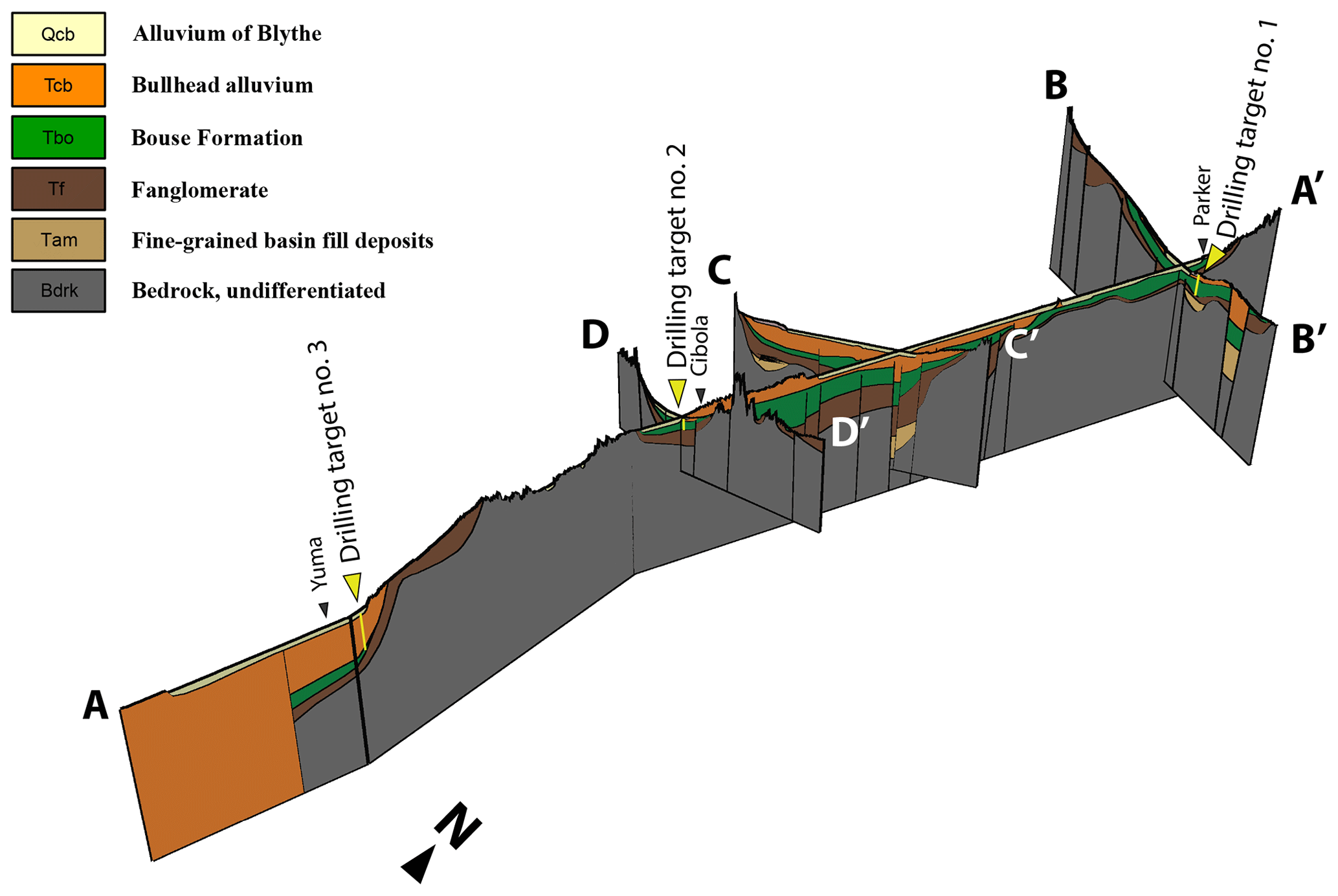
Figure 4Fence diagram of Neogene strata in the lower Colorado River corridor (Blythe and Yuma basins) assembled from driller's log data from water and geotechnical wells. Scales are variable between cross sections but vertical exaggeration is 20×. Position of cross section lines shown in Fig. 2. Lengths of cross section lines are 210, 70, 40, and 40 km for Lines A to D, respectively. The 3-D subsurface geometry reconstructed from these well data, coupled with to-be-collected seismic reflection surveys immediately adjacent to high-priority drilling areas, will be used to select the final drill sites. Well control information is based on Cassidy et al. (2018).
The stratigraphy and sedimentology of the Bouse Formation have been a major focus of work for several research groups represented at the workshop, including Kyle House and Ryan Crow (USGS); Phil Pearthree and Brian Gootee (Arizona Geological Survey); Becky Dorsey, Brennan O'Connell, and Kevin Gardner (University of Oregon); and Colleen Cassidy (University of Arizona). House, Pearthree, and Gootee discussed the general stratigraphic framework of the early Pliocene (standing water and deltaic) Bouse Formation and post-Bouse (Pliocene–Holocene) alluvial deposits formed by the through-flowing Colorado River. They reviewed evidence from a series of N–S basins for the serial decantation of solute-rich CR waters with sediments stored in each basin until the delta wedge surmounts the outlet sill, at which point the outlet converted each successive lake into a valley, removing the drainage divide and allowing rapid incision in the upstream basin. The basal deposits of the Bouse in each successive basin are carbonates, sitting over buttressed unconformities at variable elevations (inferred by Pearthree and others to represent the rapid transgression of a series of lakes). This process was repeated multiple times as the CR worked its way southwards. This “decant–deposit delta–degrade–repeat” model (Fig. 3) provides a testable hypothesis for high-resolution drill core records. Above each basal carbonate is a sequence of siliciclastic fine-grained deposits, overlain by coarser-grained gravels and conglomerates that record the successive CR deltaic and fluvial aggradation. Dorsey, O'Connell, and Gardner presented the case for a marine (and specifically marine macrotidal) depositional setting for the lower Bouse carbonate member in the Blythe basin, based on the presence of sigmoidal and compound dune bedforms, rhythmites inferred to have tidal periodicities, flaser bedding, and marine-like cements, as well as trace and body fossils discussed below. Cassidy discussed the joint USGS–UA project to digitize all existing log data (extensive but of variable quality) from research and water wells throughout the lower CR valley. These data are being used to develop realistic isopachs and structure maps of the Bouse, locating wells where the controversial basal carbonate was encountered and, from that information, predict optimal drilling targets for thick Bouse and post-Bouse sections (Fig. 4). Natalia Zakharova (Central Michigan University) discussed how downhole logging might be integrated into a future drilling campaign for the Bouse with drill core measurements of stratigraphy, and Anders Noren (University of Minnesota Continental Scientific Drilling Coordination Office) provided a “Drilling 101” primer for the many outcrop-focused geoscientists in the room.
Evidence from fossils and geochemistry weighs heavily in the Bouse debate but, like much else about the Bouse, is highly controversial. Kris McDougall-Reid (USGS) and Steve Hasiotis (University of Kansas) presented paleontological evidence from foraminiferans (some planktic species unknown from lakes) and trace fossils (e.g., burrowing shrimp typical of macrotidal flats) in support of a marine interpretation for the lower Bouse. McDougall also argued, based on biostratigraphic evidence, for a late Miocene age of the lowermost carbonates predating the arrival of CR waters. Scott Staratt discussed the potential for using diatoms to resolve the Bouse controversy. The one outcrop locality of Bouse which has been studied in detail for diatoms (well west of the main outcrop belt) contains a mix of marine and freshwater species. Similarly, Jessica Tierney (University of Arizona) discussed the potential for organic geochemical biomarkers to resolve the origins of the lower Bouse, as well as for paleoclimate studies discussed below. In contrast, Jordon Bright (Northern Arizona University) presented both stable isotope and faunal evidence from ostracodes indicating deposition of the lower Bouse in a consistently lacustrine water body, which was at times stratified and saline, but without detectable marine influence. Similarly, Laurie Crossey (University of New Mexico) studied the lowest Bouse carbonate unit, a “traver-tufa”-present ubiquitously draping pre-Bouse bedrock, which isotopically, morphologically (apparently deposited subaqueously), and paleontologically (presence of carbonate Chara algal casts) is consistent with a lacustrine origin interpretation.
Given the fill and spill framework (which is uncontested from the upstream basins) and evidence for marine incursions in the southern Blythe basin, it is clear that good geochronological control in multiple basins will be critical for evaluating the various models of how the Bouse Formation was formed. Ryan Crow and Keith Howard (USGS), Shannon Dulin (University of Oklahoma), and Steve Kuehn (Concord University) discussed the most promising dating approaches based on Ar∕Ar, magnetostratigraphy, and tephrostratigraphic data collected in basin margin outcrops to date. For example, recent advances in the combined application of 40Ar∕39Ar dating of tephras and detrital sanidine with magnetostratigraphy were discussed that suggest the CR arrived in upstream basins between 5.24 and 4.6 Ma and at the Gulf of California between 4.8 and 4.63 Ma (Crow et al., 2019b); this is about half a million years later than previously suggested. Expanded sections, which could be provided by basin center drill cores of the Bouse and post-Bouse sediments, could provide an increased probability of collecting tephras and detrital sanidines in a stratigraphic context and a more complete and accurate paleomagnetic record. The fill-and-spill model for the CR all the way south to the uncontested marine-influenced region south of the Chocolate Mountain divide makes clearly differentiated geochronological predictions for the basal Bouse Formation and onset of CR-derived siliciclastics in each basin relative to the marine incursion model. Additionally, establishing the duration of Bouse deposition is critical to determining the timescale over which the lower Colorado River, a continental-scale river, became integrated with the ocean.
The potential of the Bouse Formation to provide a detailed paleoclimate record for the southwest during the early Pliocene had not been explored prior to this workshop. However, the age of the unit coupled with the potentially time-rich record (∼100–500 kyr) during an intriguing period in Earth's history, make the Bouse a particularly compelling target for such studies. In addition to Tierney's suggested biomarker studies (in particular glycerol dialkyl glycerol tetraether (GDGT) investigations of paleotemperatures and compound specific isotopic studies of leaf waxes in the fine-grained Bouse units), the potential for fossil pollen studies of paleoclimate was discussed by Vania Stefanova (University of Minnesota), and clumped/triple oxygen isotopes were discussed by Karl Lang (Queens College) and Dan Ibarra (Stanford University), all of which seem promising approaches. Alison Smith (Kent State University) discussed other initiatives for obtaining Pliocene paleoclimate records from drill cores situated further north in western North America and how they might complement results that could arise from drill cores from the lower CR valley.
A Bouse–CR drilling project could have substantial and societally significant education and outreach dimensions. The lower CR is at the nexus of significant water rights controversies, following years of extended drought conditions in the CR basin, and both paleorecords of the CR and new subsurface information about post-Bouse aquifers could be of considerable interest. Local stakeholders from the Colorado River Indian Tribes and the Cibola National Wildlife Refuge (both of whose lands include potential drilling targets) and local municipalities were either present at the meeting and field trip or have been involved in discussions about the project to date. Amy Myrbo (University of Minnesota) discussed education and outreach programs (some derived from other successful past drilling and coring projects) that could serve as models for a future Bouse–CR-related project, focusing around training or display opportunities for local stakeholders' underserved communities which are chronically under-represented in STEM fields and especially the geosciences.
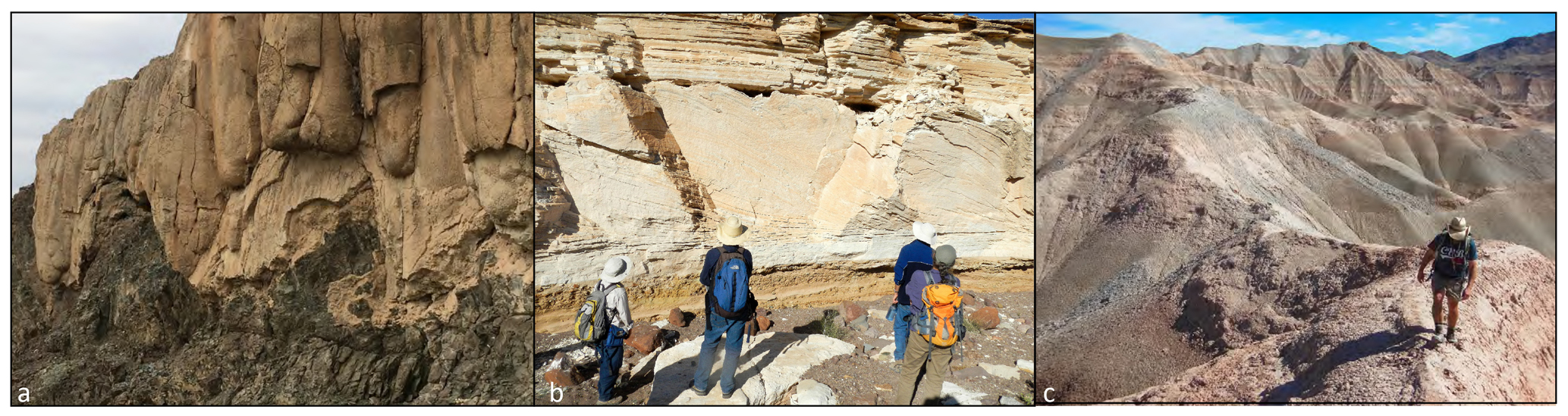
Figure 5Bouse Formation. (a) Spectacular exposure (∼12 m outcrop height, looking west) of basal Bouse “traver-tufa” draping Cretaceous metavolcanic rock (pre-Cambrian protolith) bedrock near Mesquite Mountain, northern Blythe basin near Parker, AZ, looking east (photo credit: Andy Cohen). (b) Controversial (lacustrine or marine?) cross-bedded, bioclastic carbonate of the lower Bouse Formation at Big Fault Wash (looking north), near Cibola, AZ (photo credit: Kyle House). (c) Upper Bouse siliciclastic deposits from progradational infill by the Colorado River, Mesquite Mountain (looking east), near Parker, AZ (photo credit: Charles Ferguson).
Following the presentations discussed above, breakout sessions, plenary discussions, and a field trip to visit key outcrop and potential drilling sites allowed workshop participants to consider whether and where moving forward with a drilling campaign in the lower CR valley was warranted (Fig. 5). There was a strong consensus that a series of drill cores from depocenter sites along a N–S axial transect of the Blythe and adjacent basins could help address both the key outstanding paleoenvironmental controversies surrounding the Bouse Formation. They could also provide a seminal record of both early Pliocene paleoclimate for southwestern North America and the Colorado River's paleohydrologic history (Fig. 4). In all cases the objective would be to obtain cores where the Bouse Formation is both thick (maximum probable duration and temporal resolution) and fine-grained and where the controversial basal carbonate units are both present and fossiliferous. Fortunately, indications of all of these conditions can be obtained from the compiled water or geotechnical well driller's cuttings logs (no continuous cores are available). The specific targets which seem most promising (and to provide data unlikely to be recorded in basin marginal outcrops alone) are as follows.
-
Southern Blythe basin. This is probably the most critical drill site, as it would be in close proximity to many of the outcrops (e.g., Fig. 5b) that are most central to the Bouse debate. Because of its probable lower paleo-elevation, an expanded section in the depocenter here would provide a record of the entire transgressive infilling of the basin by whatever type of standing water body was present.
-
Northern Blythe basin. A testable corollary of the fill-and-spill deltaic progradational model is that this area would provide a mostly(?) diachronous (earlier) phase of upper siliciclastic member deposition relative to the southern Blythe basin. In combination with the southern Blythe basin drill core record, an expanded fine-grained section, here it would also expand the duration of a high-resolution paleoclimate record (Fig. 5c).
-
Northern Yuma basin. Given adequate geochronologic control, a drill site immediately south of the Chocolate Mountain divide would allow unambiguous testing of the spillover hypothesis between this basin and the Blythe basin. It would also allow testing of the northerly directed marine incursion hypothesis of McDougall-Reid and Miranda Martínez (2014). No outcrops of the Bouse Formation exist in the Yuma basin, but it and its correlatives in the Imperial Formation have been identified and logged in numerous water and geotechnical wells (Olmsted et al., 1973)
-
Mohave basin. Going north from Blythe basin there was some interest in locating a drill core in this region. However, this would be a distinctly lower priority because many good Bouse depocenter outcrops exist in this region.
Workshop participants also agreed that prior to moving ahead with a full drilling proposal and campaign, additional site survey work was needed to both better identify the most optimal drilling targets and develop a “proof of concept” for likely paleoclimate and paleohydrological information that could be yielded from a study of the upper siliciclastic member of the Bouse Formation. Improved subsurface information beyond what is currently available from well control can be obtained through a shallow reflection seismic campaign, targeting the existing wells with the most optimal characteristics of thickness of fine-grained Bouse, presence of basal carbonate at or near the well, and logistical/access considerations. A proof-of-concept study would best be conducted at the relatively thick upper siliciclastic Bouse exposures on the west side of Mesquite Mountain, in the northern Blythe basin. The workshop participants recommended that both of these activities should be pursued through grant applications in the near future. Participants representing Colorado River Indian Tribes and local municipalities also made a strong case that these science activities be pursued in the context of a concerted effort to develop a meaningful education and outreach component to the project at each step of the way, beginning with the site survey work.
No data sets were used in this article.
All authors contributed with the organization and planning of the workshop. CC and RC conducted the study of prior subsurface well data. AC wrote the paper with input from all authors. RC created Figs. 1–4, with input from AC and BG, and AC produced Fig. 5.
The authors declare that they have no conflict of interest.
We thank all of the participants in this workshop for helping make it a success and pushing Bouse investigations into new directions. We also thank the Colorado River Indian Tribes (CRIT) administration, especially Brian Etsitty, Toni Carlyle, and Doug Bonamici, and the Cibola National Wildlife Refuge personnel for their assistance with this project and for providing access to CRIT and FWS land during the workshop.
This research has been supported by the US National Science Foundation (grant no. EAR-1545998).
This paper was edited by Thomas Wiersberg and reviewed by Tim Lowenstein and Kurt Constenius.
Bennett, S. E. K., Darin, M. H., Dorsey, R. J., Skinner, L. A., Umhoefer, P. J., and Oskin, M. E.: Animated tectonic reconstruction of the Lower Colorado River region: implications for Late Miocene to Present deformation. Going LOCO, Investigations along the Lower Colorado River: Desert Studies Center Desert Symposium Field Guide and Proceedings, 15–18 April 2016, California State University Desert Studies Center Zzyzx, CA, USA, 73–86, 2016.
Block, D., Gootee, B. F., House, P. K., and Pearthree, P. A.: Geologic Map of the Blythe 7.5' quadrangle, La Paz County, Arizona and Riverside County, California. Arizona Geological Survey Digital Geologic Map 124 (DGM-124), 2 sheets and text, Tucson, AZ, USA, 2019.
Bright, J., Cohen, A. S., Dettman, D. L., Pearthree, P. A., Dorsey, R. J., and Homan, M. B.: Did a catastrophic lake spillover integrate the late Miocene early Pliocene Colorado River and the Gulf of California? Microfaunal and stable isotope evidence from Blythe basin California-Arizona, USA, Palaios, 31, 81–91, https://doi.org/10.2110/palo.2015.035, 2016.
Bright, J., Cohen, A. S., Dettman, D. L., and Pearthree, P. A.: Freshwater plumes and brackish lakes: integrated microfossil and O-C-Sr isotopic evidence from the late Miocene and early Pliocene Bouse Formation (California-Arizona) support a lake overflow model for the integration of the lower Colorado River corridor, Geosphere, 14, 1875–1911, https://doi.org/10.1130/GES01610.1, 2018a.
Bright, J., Cohen, A. S., and Starratt, S.: Distinguishing brackish lacustrine from brackish marine deposits in the stratigraphic record: A case study from the late Miocene and early Pliocene Bouse Formation, Arizona and California, USA, Earth Sci. Rev., 185, 974–1003, https://doi.org/10.1016/j.earscirev.2018.08.011, 2018b.
Buising, A.: The Bouse Formation and bracketing units, southeastern California and western Arizona: implications for the evolution of the proto-Gulf of California and the lower Colorado River, J. Geophys. Res., 95, 20111–20132, https://doi.org/10.1029/JB095iB12p20111, 1990.
Cassidy, C. E., Crow, R., House, P. K., Thacker, J. O., Beard, L. S., Cohen, A. S., Pearthree, P. A., and Howard, K. A.: Subsurface dta in the Lower Colorado River corridor and its implications for tectonic models of basin evolution within the Palo Verde and Parker Valleys. GSA Cordilleran/Rocky Mtn Sect. Mtg., Flagstaff, AZ, USA, Paper 64-28, 2018.
Crossey, L. C., Karlstrom, K. E., Dorsey, R., Pearce, J., Wan, E., Beard, L. S., Asmerom, Y., Polyak, V., Crow, R. S., Cohen A., Bright, J., and Pecha, M. E.: The importance of groundwater in propagating downward integration of the 6–5 Ma Colorado River System: Geochemistry of springs, travertines and lacustrine carbonates of the Grand Canyon region over the past 12 million years, Geosphere. Special Issue CRevolution 2: Origin and Evolution of the Colorado River System II, 11, 660–682, 2015.
Crow, R. S., Block, D., Felger, T. J., House, P. K., Pearthree, P. A., Gootee, B. F., Youberg, A. M., Howard, K. A., and Beard, L. S.: The Colorado River and its deposits downstream from Grand Canyon in Arizona, California, and Nevada, Open-File Report no. 2018-1005, U.S. Geological Survey, Reston, VA, USA, 1–6, 2018.
Crow, R. S., Howard, K. E., Beard, L. S., Pearthree, P. A., House, P. K., Karlstrom, K. E., Peter, L., McIntosh, W., Cassidy, C., Felger, T. J., and Block, D.: Insights into post-Miocene uplift of the western margin of the Colorado Plateau from the stratigraphic record of the lower Colorado River, Geosphere, 15, 1–20, https://doi.org/10.1130/GES02020.1, 2019a.
Crow, R. S., Schwing, J., Karlstrom, K. E., Heizler, M., Pearthree, P. A., House, P. K., Dulin, S. A., Stelten, M. E., and Crossey, L. J.: Redefining the age of the Colorado River, GSA Ann. Mtg., Phoenix, AZ, USA, Paper 134-9, 2019b.
Dorsey, R. J., O'Connell, B., McDougall, K., and Homan, M.: Punctuated sediment discharge during Early Pliocene birth of the Colorado River: Evidence from regional stratigraphy, sedimentology and paleontology, Sediment. Geol., 363, 1–33, 2018.
Drury, A. J., Lee, G. P., Gray, W. R., Lyle, M., Westerhold, T., Shevenell, A. E., and John, C. M.: Deciphering the state of the Late Miocene to Early Pliocene Equatorial Pacific, Paleoceanography and Paleoclimatology, 33, 246–263, https://doi.org/10.1002/2017PA003245, 2018.
Gootee, B. F., Pearthree, P. A., House, P. K., Youberg, A., O'Connell, B., and Bright, J.: A sequence-stratigraphic interpretation of the upper bioclastic unit capping the Bouse Formation in the Cibola Area, Arizona and California. In Going LOCO: Investigations along the Lower Colorado River: California State University Desert Studies Center 2016 Desert Symposium Field Guide and Proceedings, 15–18 April 2016, California State University Desert Studies Center, Zzyzx, CA, USA, 154–159, 2016.
House, P. K., Pearthree, P. A., and Perkins, M. E.: Stratigraphic evidence for the role of lake spillover in the inception of the lower Colorado River in southern Nevada and western Arizona, in: Late Cenozoic drainage history of the southwestern Great Basin and lower Colorado River region: Geologic and biologic perspectives, edited byL Reheis, M. C., Hershler, R., and Miller, D. M., Geol. S. Am. S., Boulder, CO, USA, 439, 335–353, https://doi.org/10.1130/2008.2439(15), 2008.
House, P. K., John, B. E., Malmon, D. V., Block, D., Beard, L. S., Felger, T. J., Crow, R. S., Schwing, J. E., and Cassidy, C. E.: Geologic map of the Castle Rock 7.5' quadrangle, Arizona and California. U.S. Geological Survey Scientific Investigations Map 3411, scale 1 : 24 000, pamphlet 15, https://doi.org/10.3133/sim3411, 2018.
Howard, K. A., House, P. K., Dorsey, R. J., and Pearthree, P. A.: River-evolution and tectonic implications of a major Pliocene aggradation on the lower Colorado River: The Bullhead Alluvium, Geosphere, 11, 1–30, https://doi.org/10.1130/GES01059.1, 2015.
Karlstrom, K., Liu, L., Zhou, Q., Crossey, L., Thacker, J., Crow, R., and Beard, S.: Mechanisms for post-Bouse (post 5 Ma) deformation in the lower Colorado River region. ECSZ Does it: Revisiting the Eastern California Shear Zone 2017 Desert Symposium Field Guide and Proceedings, 14–17 April 2017, Fullerton CA Desert Studies Center, Zzyzx, CA, USA, 145–149, 2017.
Lundstrom, S. C., Mahan, S. A., Paces, J. B., Hudson, M. R., House, P. K., Malmon, D. V., Blair, J. L., and Howard, K. A.: Late Pleistocene aggradation and degradation of the lower Colorado River: Perspectives from the Cottonwood area and other reconnaissance below Boulder Canyon, in: Late Cenozoic drainage history of the southwestern Great Basin and lower Colorado River region: Geologic and Biotic perspectives, edited by: Reheis, M. C., Hershler, R., and Miller, D. M., Geol. Soc. Am. Spec. Pap., 439, 409–430, 2008.
Malmon, D. V., Howard, K. A., House, P. K., Lundstrom, S. C., Pearthree, P. A., Sarna-Wojcicki, A. M., Wan, E., and Wahl, D. B.: Stratigraphy and Depositional Environments of the Upper Pleistocene Chemehuevi Formation Along the Lower Colorado River, Professional Paper 1786, U.S. Geological Survey, Reston, VA, USA, 1–95, 2011.
McDougall, K.: Late Neogene marine incursions and the ancestral Gulf of California, in: Late Cenozoic drainage history of the southwestern Great Basin and lower Colorado River region: Geologic and biologic perspectives, edited by: Reheis, M. C., Hershler, R., and Miller, D. M., Boulder, Colorado, USA, Geol. S. Am. S., 439, 355–373, https://doi.org/10.1130/2008.2439(16), 2008.
McDougall, K. and Miranda Martínez, A. Y.: Evidence for a marine incursion along the lower Colorado River corridor, Geosphere, 10, 842–869, https://doi.org/10.1130/GES00975.1, 2014.
Metzger, D. G.: The Bouse Formation (Pliocene) of the Parker-Blythe-Cibola area, Arizona and California, Professional Paper, 600-D, U.S. Geological Survey, Washington, D.C., USA, 126–136, 1968.
O'Connell, B., Dorsey, R. J., and Humphreys, E. D.: Tidal rhythmites in the southern Bouse Formation as evidence for post-Miocene uplift of the lower Colorado River corridor, Geology, 45, 99–102, https://doi.org/10.1130/G38608.1, 2017.
Olmsted, F. H., Loeltz, O. J., and Irelan, B.: Geohydrology of the Yuma Area, Arizona and California, Professional Paper, 486-H, U.S. Geological Survey, Washington, D.C., USA, 1–227, 1973.
Pearthree, P. A. and House, P. K.: Paleogeomorphology and evolution of the early Colorado River inferred from relationships in Mohave and Cottonwood valleys, Arizona, California, and Nevada, Geosphere, 10, 1139–1160, https://doi.org/10.1130/GES00988.1, 2014.
Roskowski, J. A., Patchett, P. J., Spencer, J. E., Pearthree, P. A., Dettman, D. L., Faulds, J. E., and Reynolds, A. C.: A late Miocene-early Pliocene chain of lakes fed by the Colorado River: Evidence from Sr, C, and O isotopes of the Bouse Formation and related units between Grand Canyon and the Gulf of California, Geol. Soc. Am. Bull., 122, 1625–1636, https://doi.org/10.1130/B30186.1, 2010.
Spencer, J. E. and Patchett, P. J.: Sr isotope evidence for a lacustrine origin for the upper Miocene to Pliocene Bouse Formation, lower Colorado River trough, and implications for timing of Colorado Plateau uplift, Geol. Soc. Am. Bull., 109, 767–778, https://doi.org/10.1130/0016-7606(1997)109<0767:SIEFAL>2.3.CO;2, 1997.
Spencer, J. E., Pearthree, P. A., and House, P. K.: An evaluation of the evolution of the latest Miocene to earliest Pliocene Bouse lake system in the lower Colorado River valley, southwestern USA, in: Late Cenozoic drainage history of the southwestern Great Basin and lower Colorado River region: Geologic and biologic perspectives, edited by: Reheis, M. C., Hershler, R., and Miller, D. M., Boulder, Colorado, USA, Geol. S. Am. S., 439, 375–390, https://doi.org/10.1130/2008.2439(17), 2008.
Spencer, J. E., Patchett, P. J., Pearthree, P. A., House, P. K., Sarna-Wojcicki, A. M., Wan, E., Roskowski, J. A., and Faulds, J. E.: Review and analysis of the age and origin of the Pliocene Bouse Formation, lower Colorado River Valley, southwestern USA, Geosphere, 9, 444–459, https://doi.org/10.1130/GES00896.1, 2013.
Spencer, J. E., Constenius, K., and Bright, J.: Evidence of a lacustrine origin for laminated marl of the Pliocene Bouse Formation, Milpitas Wash, Blythe Basin, lower Colorado River valley, Arizona Geological Survey Contributed Report, CR-18-K, Tucson, AZ, USA, 33 pp., 2018.
- Abstract
- Introduction
- Workshop goals
- Paleohydrological and paleoclimatic research and education & outreach objectives of a lower Colorado River scientific drilling project
- Recommendations of the workshop
- Data availability
- Author contributions
- Competing interests
- Acknowledgements
- Financial support
- Review statement
- References