 | 26 Oct 2023
Workshop on drilling the Nicaraguan lakes: bridging continents and oceans (NICA-BRIDGE)
Mark Brenner
Robert A. Dull
Armin Freundt
Jens Kallmeyer
Sebastian Krastel
Sergei Katsev
Elodie Lebas
Axel Meyer
Liseth Pérez
Juanita Rausch
Armando Saballos
Antje Schwalb
Wilfried Strauch
An international, multidisciplinary research group is proposing the “NICA-BRIDGE” drilling project, within the framework of the International Continental Scientific Drilling Program (ICDP). The project goal is to conduct scientific drilling in Lake Nicaragua and Lake Managua (Nicaragua, Central America) to obtain long lacustrine sediment records to (a) extend the neotropical paleoclimate record back to the Pliocene, making it one of the longest continental tropical climate archives in the world, and to (b) provide geological data on the long-term complex interplay among tectonics, volcanism, sea-level dynamics, climate change, and biosphere.
The lakes are the two largest in Central America, and they are located in a trench-parallel half graben that hosts the volcanic front, which developed during or prior to the Pliocene, as a consequence of subduction-related tectonic activity. The lakes are uniquely suited for multidisciplinary scientific investigation as their long, continuous sediment records (several Myr) will facilitate the study of (1) terrestrial and marine basin development at the southern Central American margin, (2) alternating lacustrine and marine environments in response to tectonic and climatic changes, (3) the longest record of tropical climate proxies, (4) the evolution of (and transition between) the Miocene to Pliocene/Pleistocene and Pleistocene to present volcanic arcs, which were separated by slab rollback, (5) the significance of the lakes as hot spots for endemism, and (6) the Great American Biotic Interchange at this strategic location, i.e., the N–S and reverse migration of fauna after the land bridge between the Americas was established.
The planned ICDP project offers an opportunity to explore these topics through continent-based seismological, volcanological, paleoclimatological, paleoecological, and paleoenvironmental studies, combined with an International Ocean Discovery Program (IODP) drill project to explore its oceanic continuation.
In preparation of this drilling project, an ICDP workshop was held in Montelimar, Nicaragua, on 2–5 March 2020 to develop drilling strategies and refine scientific questions, objectives, and hypotheses. The workshop was organized and hosted by the principal investigators and the Instituto Nicaragüense de Estudios Territoriales (INETER), with funding from the ICDP. Forty-five researchers from 12 countries participated in the workshop, including representatives from ICDP. During the workshop, previous research data on the study lakes, including new recent surveys, were reviewed, and a three-phase strategy for the proposed research was developed. The aim of Phase 0 is to complement the pre-site surveys where we identified the need for further data. In Phase I, with ICDP support, we will obtain sediment cores ∼ 100 m long, which will allow us to investigate many of the scientific questions. Based on the data from those drill cores, coring locations will be identified for a future Phase II, which we envisage as a combined ICDP/IODP project to collect deep drill cores in the lakes and the offshore Sandino Basin in order to extend Phase I results to much deeper time. The Sandino Basin is the oceanic continuation of the depression in which the studied lakes are located, and complementary marine drilling will improve the understanding of the evolution of this complex margin.
- Article
(4466 KB) - Full-text XML
- BibTeX
- EndNote


The two largest lakes in Central America, Lake Nicaragua (Cocibolca) and Lake Managua (Xolotlán), are situated in south-central Nicaragua and represent the largest sources of freshwater in the region (Fig. 1). They are located in the central part of the Mesoamerican Biological Corridor and host numerous endemic species such as cichlid fishes (Kautt et al., 2012). Given their proximity to the Isthmus of Panama, their sediments probably record its closure, which is one of the most important events in the diversification and extinction of late Cenozoic and modern species in North America, South America, and the Caribbean region (Montes et al., 2015). The origin of the lakes, as well as the tectonic depression hosting them, dates to at least the Pliocene, but the origin of the tectonically related marine Sandino Basin can probably be traced back even further to the Late Miocene (Funk et al., 2009). The lakes cover a combined surface area of ∼ 9000 km2 in the tectonically active Nicaraguan Depression, which hosts the Central American volcanic front (Funk et al., 2009). The prominent 40 to 70 km wide depression extends for ∼ 1000 km, from the Caribbean side of Costa Rica in the southeast to the northern Gulf of Fonseca in El Salvador (Case and Holocombe, 1980; Funk et al., 2009; Mann et al., 1990). Funk et al. (2009) and Ranero et al. (2000) claimed that the two lakes possess at least 500 m of Quaternary sediment and an additional 2000 m of Pliocene sediment fill. Early reports on the geology and structure, based on K/Ar-dated volcanogenic sediments at lakeshore outcrops (McBirney and Williams, 1965; Weinberg, 1992), suggested three major tectonic phases during the basin evolution: (1) Miocene convergence, (2) Pliocene extension, and (3) Pleistocene-to-present transtensional deformation. During that long time period, the position of the volcanic front shifted in response to slab rollback, from a Miocene arc along the eastern border of the Nicaragua Depression to the Pleistocene-to-recent front that cuts through the lakes, making the depression an intra-arc basin (Taylor, 1995).
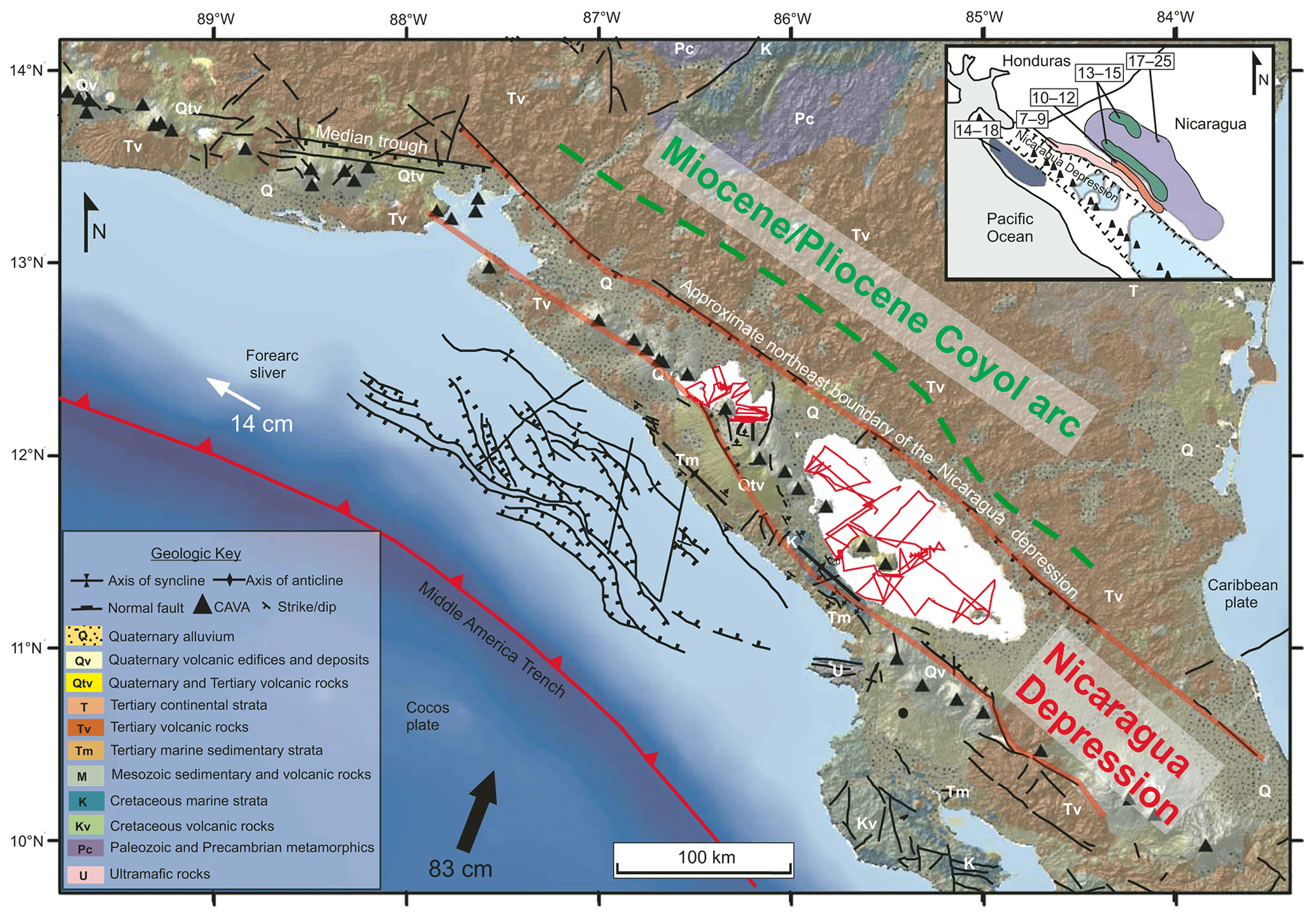
Figure 1Overview map of the Central American subduction zone at Nicaragua, modified after Funk et al. (2009). Red lines outline the Nicaraguan Depression that hosts Lake Nicaragua (LN) and Lake Managua (LM) in which red lines show seismic profiles from pre-site survey. Triangles mark the Pleistocene-to-recent volcanic arc (CAVA), whereas purple and green areas outline the older Coyol arc. White labeling inside the geological maps assists identification of units shown in the legend to the lower left. Fault lines on the submarine forearc outline the Sandino Basin. Inset shows presumed ages of volcanic rocks since the Miocene.
The following scientific motivations to initiate this project were subjected to challenging discussions during the workshop.
2.1 Tectonics and volcanism
Geographic separation of areas of different ages in the Central American volcanic arc (Fig. 1, Coyol and recent arc), together with the expected approximately continuous sedimentation in the long-lived, coexisting tectonic basins, is a situation unique to Nicaragua. Therefore, in addition to providing a very long paleoenvironmental record, sediment cores from the basin will yield important data on the tectonic and volcanic evolution of the arcs, particularly during the period of shift (how long, existence of volcanic hiatus), from the eastern Tertiary Coyol arc to the western Upper Pleistocene arc (Funk et al., 2009), and provide information that can be used to evaluate the three existing regional tectonic models for the origin of the Nicaragua depression and therefore the depositional area of the lakes: (1) transform fault model, (2) pull-apart model, and (3) bookshelf faulting model (Funk et al., 2009). Abundant volcanic deposits in sediment successions on land and in the Pacific Ocean prove the existence of radiometrically datable time markers from recent to Miocene (Kutterolf et al., 2007, 2008; Jordan et al., 2007; Schindlbeck et al., 2016; Ehrenborg 1996). Dating methods for tephras include 14C (< 50 ka), 238U–230Th and (U–Th) He dating of zircon crystals (evolved tephras), and 40Ar 39Ar single-crystal dating (K-rich minerals), which cover the expected age range. Fauna-bearing sediments provide additional age constraints through stable-isotope and micropaleontological analyses.
The geographic position of the Nicaraguan lakes makes them ideal for a “paleo-study” as they are upwind from the modern, ∼ 1 Ma, volcanic arc system and far downwind (50–100 km) from the ancient, > 1.5 Ma, Tertiary volcanic arc system (Schindlbeck et al., 2016), thus potentially providing a continuous record of tephras from both arcs but without the risk of thick, impenetrable volcanic deposits. The long tephra records will help decipher the frequency of explosive eruption at the Coyol arc compared to the modern volcanic front, the duration of the arc shift, the occurrence or not of a volcanic hiatus during the shift, and associated changes in magmatic compositions (which, in turn, reflect crustal storage and mantle melting conditions). Accumulation rates of sediment bracketed by dated primary volcanic deposits, combined with sedimentological and geochemical analyses, can yield time series of tectonic activity/subsidence and climate changes, together with rates of volcanic activity, enabling us to investigate possible cross-correlations.
2.2 Paleoclimate
The availability of abundant radiometrically datable volcanic deposits in the sediment cores is an important advantage for obtaining a long, continuous paleoclimate record that will extend much farther back in time than those retrieved from Lake Petén Itzá, Guatemala (∼ 410 ka; Mueller et al., 2010; Correa-Metrio et al., 2012; Kutterolf et al., 2016), and Lake Chalco, central Mexico (∼ 400 ka; Brown et al., 2019). Sediment cores from the Nicaraguan lakes and the analysis of different proxies (stable isotopes, biomarkers, pollen, sediment geochemistry) have the potential to extend the neotropical paleoclimate record back to at least the Pliocene, which would place them among the oldest archives of continental tropical paleoclimate in the world. They will be unparalleled for study of the long history of Intertropical Convergence Zone (ITCZ) oscillations and related changes in precipitation. The large Nicaraguan lakes, at ∼ 12∘ N latitude, are ideally located in the heart of the northeast trade wind belt to record past variations in climate, driven by changes in the El Niño–Southern Oscillation (ENSO), i.e., fluctuations in near-equatorial sea surface temperature and air pressure that affect precipitation on land, with consequences such as floods, droughts, and wildfires (e.g., Cai et al., 2020). The ENSO record of the cores may also serve as a record of environmental impacts, which may have been modified by different land–sea relationships in the past.
2.3 Paleoecology and biosphere
The two study lakes offer an opportunity to relate their paleobiological inventory to salinity changes through time and to distinguish between ITCZ-controlled shifts in evaporation/precipitation ratio and salinity changes caused by tectonically controlled marine transgressions/regressions over the last several million years. The combination of micropaleontological, stable isotope, and sedimentological data from a suite of cores will help distinguish between tectonic and climate controls on biotic shifts. The biological proxies we have identified as most important include diatoms, ostracodes, foraminifers, and microbes. Diatoms, ostracodes, and foraminifers are sensitive to changes in water level, salinity, and ionic dominance, whereas a change in the abundance and structure of the microbial communities might serve as evidence of abrupt environmental and climate change (Moguel et al., 2021). We expect that the dramatic environmental changes in the lake region also affected proxy preservation, and we will therefore use a multi-proxy approach (diverse microfossils, biomarkers, and DNA) to provide a full record of paleoenvironmental conditions. We will investigate the hypothesis that there were repeated saltwater–freshwater interactions that arose from marine transgressions and regressions over the poorly known period when the ocean gateway closed. Repeated past connections with the marine environment presumably had substantial influence on lacustrine ecosystem biodiversity. This can be investigated, for example, by using taxa and selected genomic signatures preserved in the sediments (e.g., fishes; Kautt et al., 2012) to infer which taxa were present and how they responded and adapted to environmental changes through time. This will allow us to determine and compare evolution, diversification, and turnover rates in freshwater, brackish, and marine ecosystems. For example, diversification and turnover of diatoms appear to be more rapid in freshwaters (Nakov et al., 2019). Moreover, the combination of pollen and aquatic bioproxies will generate high-resolution information on regional and local biota since the Pliocene. Repeated marine–freshwater successions also provide a potential opportunity to study non-steady-state geochemistry in a sedimentary system and its effects on microbial community composition and metabolic activity.
Our climate and environmental record (Sect. 2.2 and 2.3) will be compared with other neotropical sediment records with similar temporality. For instance, in Phase I (Sect. 3) we will retrieve and study parallel pre-Holocene sediment cores (∼ 100 m long), and multi-proxy results will be compared with those from other late Quaternary records such as Lake Petén Itzá, Guatemala (Mueller et al., 2010); Lake Chalco, central Mexico (Brown et al., 2019); and the Cariaco Basin (Schneider et al., 2014). Deeper and older sediment records from Lake Nicaragua will be compared with evidence from ICDP (International Continental Scientific Drilling Program) sites extending much further back in time, including Izabal (Guatemala, ∼ 10 Ma; Obrist-Farner et al., 2020) and Colônia (Brazil, ∼ 5 Ma; Ledru et al., 2015). The previous data will allow us to (1) infer changes in the composition and structure of vegetation and aquatic communities since the Pliocene and (2) study the interplay between ENSO and the migration of the ITCZ. In addition, we will contribute to the knowledge of regional biogeography, and multi-proxy data will reveal the interactions between native terrestrial and aquatic species and colonizers, especially since the Great American Biotic Interchange and closure of the Isthmus of Panama.
2.4 Hazards
Detailed investigation of the Nicaraguan lake histories, far beyond the timescale previously studied in Central America (i.e., late Pleistocene), is germane to socio-economic issues of local, regional, and global significance, especially with respect to persistent threats from natural hazards in Nicaragua such as, for example, Managua's large earthquakes in 1931, 1972, and 2014 and the eruptions of the Cerro Negro (1992, 1995, 1999) and Momotombo (2015/2016) volcanoes. In addition to these hazards, there is also evidence for seismogenic and volcanogenic tsunamis in the lakes (Freundt et al., 2006, 2007) and in the near-shore Pacific region (Heesemann et al., 2009), disastrous lahars (Casita Volcano killed > 2000 persons in 1998), and massive landslides from the large, unstable volcanic edifices like Momotombo, Concepción, and Mombacho, with the last one responsible for ∼ 400 deaths in 1570 (Vallance et al., 2001). Many of these hazardous events will have manifested themselves as identifiable layers in the lake sediments; next to the obvious tephras, possible examples include turbidites, seismites, and storm layers. Long time series for these hazards, derived from the drill cores, will shed light on the underlying processes that cause them, their magnitudes, and the frequencies at which they re-occur. Seismic monitoring by INETER and new seismological research projects (TUCAN project; Harmon et al., 2008) have documented the presence of active tectonic faults below the lakes, and hydrothermal springs atop the faults are observed on land. Downhole logging of drill holes for temperature, in combination with measurements of thermal conductivity from core samples, will provide further constraints on tectonic activity and heat flux in and around the lakes.
2.5 Environment
In 2009, the Sandino wastewater-treatment facility was installed on the shore of Lake Managua, with the aim of improving lake water quality. This effort came after > 80 years of uncontrolled cultural eutrophication and contaminant pollution. Sediment and porewater, as well as microbial community analyses from cores taken in both lakes, will enable us to determine the penetration depth of pollutants into the lake deposits and their potential for being released back into the water column. Such information will be critical for evaluating how the quality of lake water and deeper groundwater would be affected by continuous pollution and by large-scale infrastructure projects in tropical lakes worldwide but in Nicaraguan lakes specifically. It will shed light on the potential impacts of the proposed construction of a canal through Lake Nicaragua that would connect the Caribbean Sea and the Pacific Ocean.
Sediment cores collected in 2006 from Lake Petén Itzá, Guatemala, revealed dramatic temperature and rainfall changes during the last 85 kyr, which had profound impacts on local terrestrial and aquatic environments, e.g., vegetation changes and lake water ion concentrations, respectively (Hodell et al., 2012; Escobar et al., 2012; Cohuo et al., 2018; Pérez et al., 2021). Much longer drill cores (and hence older deposits) from the Nicaraguan lakes will provide insights into the development of modern lake biodiversity, the impacts of climate change and abrupt natural events (e.g., volcanic eruptions, tsunamis) on aquatic biota and their possible recovery, and the environmental consequences of human activities, both past (unconstrained discharge of sewage and pollutants) and future (the planned canal through Lake Managua). Results related to these recent and ongoing environmental problems will be disseminated to the public and agency officials through suitable outreach activities (e.g., school lessons, professional training, local workshops).
In summary, long, continuous sediment cores from multiple sites in Lake Managua and Lake Nicaragua will provide some of the oldest lacustrine records of paleoclimate and paleoenvironment in the continental neotropics. The use of an array of drill sites (in Phase I, Sect. 3) is important for a continuous record, because possible gaps at one site can be filled by correlations with the other sites. The cores will thus enable us to (a) infer high-resolution neotropical paleoclimate and paleoenvironmental conditions; (b) determine the times and rates of marine transgressions and regressions, their aquatic and terrestrial ecological consequences, and their tectonic and climatic controls, also in connection with the timing, duration, and impacts of the closure of the Isthmus of Panama; (c) identify linkages between long terrestrial and marine paleoenvironmental records; (d) investigate the magnitudes and recurrence rates of natural hazards, e.g., volcanic eruptions, landslides, tsunamis, earthquakes, hurricanes; (e) constrain the timing of shifts of the volcanic arc and associated changes in magmatic compositions and volcanic activity; (f) understand the long-term basin development and the deeper structure of western Nicaragua; and (g) assess climatic, geologic, and (Holocene) anthropogenic influences on limnological variables and lake biodiversity, e.g., past freshwater/saltwater phases initiated by tectonics and consequent effects on micro-biota and macro-biota.
The workshop on the NICA-BRIDGE project was held in Montelimar, Nicaragua, from 2 to 5 March 2020, and it included a field trip to Lake Nicaragua and nearby volcanoes. The workshop agenda included plenary and working-group discussions that covered themes such as scientific objectives, specific drilling targets and respective challenges, and a proposal strategy to achieve the project goals. Specific topics discussed included issues related to drilling rigs to be deployed, analyses to be completed on cores, priority sections of the sediment sequences, and parallel in situ limnological monitoring, as well as logistical considerations, such as developing broad international scientific collaborations, acquiring complementary research funding, defining outreach activities, and obtaining permits. The consensus was that we will develop a multi-phase project that will involve long-term scientific engagement in the region, which will include scientific contributions for the improvement of seismic, volcanic, and tsunami monitoring and early warning by INETER.
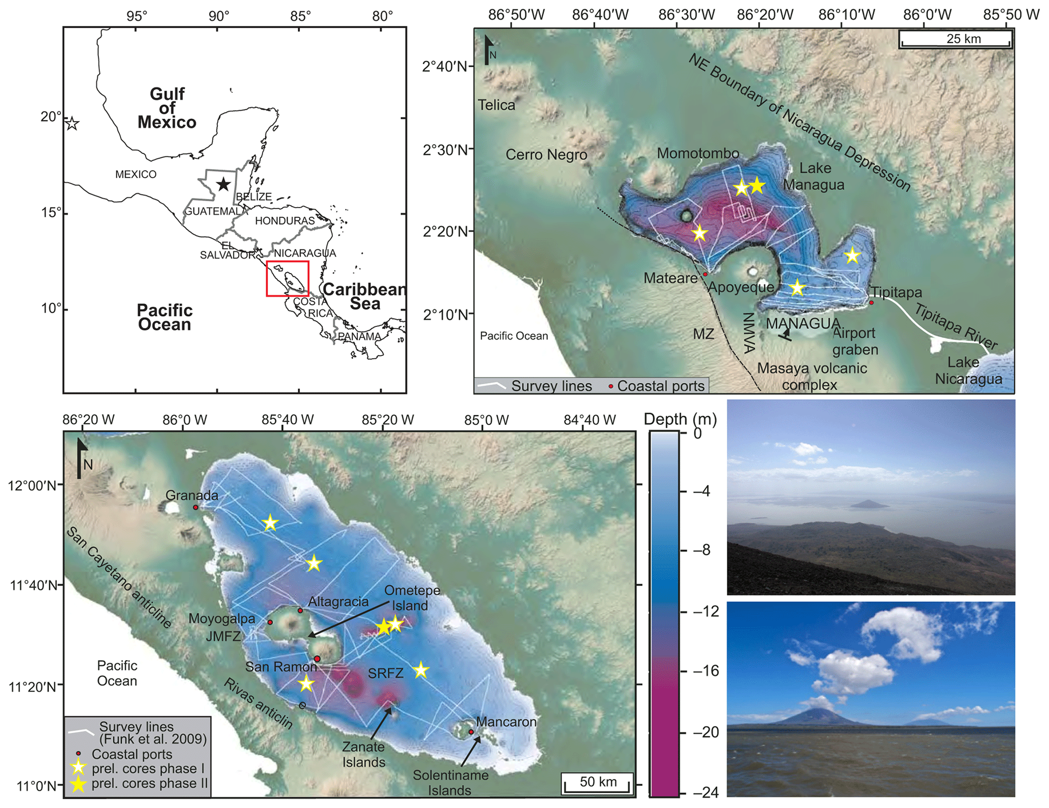
Figure 2Upper left: map of southern Mexico and Central America, showing the location of the Nicaraguan study lakes. Red box indicates the area detailed in the map to the right and bottom left, and the stars are other ICDP drill sites in the region (black star represents Petén Itzá, Guatemala; white star represents Chalco, Mexico). Shuttle Radar Topography Mission imagery of Lake Managua (upper right) and Lake Nicaragua (lower left), and the Central America volcanic front in Nicaragua, modified from Funk et al. (2009). White lines show survey lines conducted by Funk et al. (2009). Bathymetric data are from the Nicaraguan hydrographic department of the Instituto Nicaragüense de Estudios Territoriales (unpublished data of INETER collected in 1979) and were supplemented by bathymetric data collected by Funk et al. (2009). Yellow stars indicate tentative locations of sites to be drilled to address scientific questions in Phases I and II of the project. Lower right: upper photo, showing Lake Managua with Momotombito Volcano, and lower photo, showing Lake Nicaragua, with Ometepe island with the Concepción and Maderas volcanoes. Photos by Steffen Kutterolf.
Seismic profiles obtained in 2017 were presented at the opening of the workshop and were the basis for the discussions that followed. Twenty-seven seismic profiles were collected in Lake Nicaragua along a NW–SE transect, with several crosslines shot roughly NW–SE and ENE–WSW to the mainline (Fig. 2). The seismic lines covered a total length of ∼ 320 km. Unfortunately, high gas content in surface sediments often attenuated the signal, preventing the sound source from penetrating deep into the sediments. We were, however, able to collect good images from one region in the central part of the lake, which revealed a > 300 m thick sedimentary succession and provides evidence that long, continuous sediment cores can be obtained from Lake Nicaragua. The age at the base of the succession is unknown, but based on the near-surface sedimentation rate (0.3 m kyr−1) an age of ∼ 1 Ma at 300 m sediment depth can be hypothesized. However, only long cores will provide data for a well-grounded age estimate.
Short sediment cores obtained by Robert A. Dull (California Lutheran University, USA) from Lake Nicaragua provide evidence for predominantly muddy lacustrine sedimentation (gyttja), intercalated with centimeter thick volcanogenic sediments in the topmost ∼ 4 m (Fig. 2). Sediment accumulation rates have fluctuated but display a mean of ∼ 30 cm kyr−1. Preliminary geochemical and biological investigations of these cores conducted by Robert A. Dull, Sabine Wulf, Jennifer Slate, and Amy Bloom revealed variations within the last 12 kyr (Dull et al., 2023). Robert A. Dull has granted us access to the 35 short cores, which will be investigated to supplement the pre-site survey data.
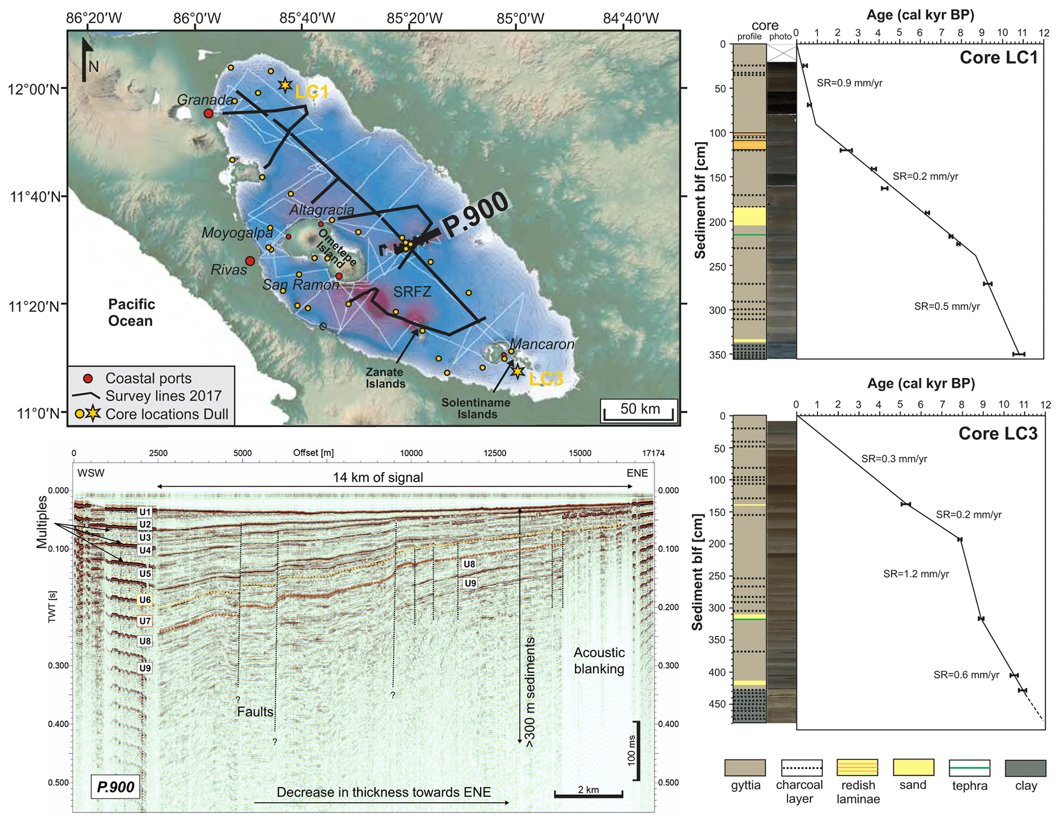
Figure 3Upper left: Shuttle Radar Topography Mission imagery of Lake Nicaragua and the Central American volcanic front in southern Nicaragua, modified from Funk et al. (2009). Locations of seismic pre-site survey profiles from 2017 are shown with black lines. Seismic profile shown in the lower left is marked in bold. Light orange dots show locations of shallow cores collected by Robert A. Dull and colleagues in 2006. Sampling sites where the two cores in the right panels were collected are indicated by yellow stars on the lake map. Lower left: air gun seismic profile (P.900) east of Ometepe island, showing the upper 400 ms TWT (> 300 m, where TWT represents two-way travel time) of the sedimentary succession of the lake. Right panels: schematic profiles of two sediment cores from Lake Nicaragua (see upper left for location), showing the first ∼ 4 m and respective 14C ages of lacustrine sedimentation. The cores are composed mainly of gyttja and intercalated tephra and sand beds, and they indicate an average sedimentation rate of ∼ 30 cm kyr−1 in the uppermost meters. Note that the tephra in LC1 probably correlates to the ∼ 6 ka San Antonio tephra from Masaya Caldera, Nicaragua.
After presentation of seismic survey data on the first morning of the workshop (2 March), each participant introduced themselves and presented their respective expertise. This was followed by contributed talks from a number of attendees – presentations that covered multiple topics related to the NICA-BRIDGE project scientific goals, with the objective of honing old and new hypotheses, exploring drilling options, and evaluating the objectives of our study in relation to similar projects carried out previously in Central America, in adjacent areas and elsewhere. On 3 March we took a field trip to familiarize workshop participants with the landscape and the lakes. The trip involved a boat tour and a visit to the nearby Apoyo Caldera, which is the source of the largest eruption in Nicaragua in the Late Quaternary (Fig. 3). On 4 March we divided into subgroups to focus on six overarching scientific themes: (1) paleoclimate; (2) paleoecology, biodiversity, and deep biosphere; (3) magmatic and volcanic evolution; (4) environmental impacts and physical limnology; (5) human occupation, migration, and archeology; and (6) basin history and seismogenic hazards. We used the breakout sessions to evaluate, update, modify, and consolidate the objectives listed in the workshop proposal.
3.1 The three-phase approach
After reconvening on Wednesday afternoon, summaries of the breakout sessions were presented and discussed by all participants. It soon became clear that we had to give greater thought to our overall scientific strategy and phasing of proposals to ICDP and IODP. We discussed the prerequisites for each stage of the project and before sunset the 45 participants agreed we would adopt a three-phase approach.
Phase 0 includes the completed pre-site surveys and will include further (and adjusted) seismic surveys, as well as collection of cores that are longer (pre-Holocene) than those presently available. The main challenge for the seismic survey is to overcome the problem of gas-rich sediments, but it is essential for selection of optimum drilling sites. Piston cores > 10 m long will be taken with a piston corer. Such cores will establish if pre-Holocene sediments that lie below presumably harder or more clay-rich sediments in seismic unit “U2” (Fig. 2) can be drilled by piston coring and if the sediments are suitable for the proposed investigations. Funding will be obtained from national funding agencies, and submission of related proposals will start promptly to make it possible to carry out the field campaign as soon as possible.
If Phase 0 is successful, i.e., it reveals feasible target locations for drilling and yields moderately long cores, Phase I will be addressed in the first full ICDP proposal. Phase I will involve drilling of longer cores (∼ 100 m) at several sites in both lakes to achieve multiple objectives, which may, however, be limited to the Late Quaternary.
Results from Phase I will be crucial for the development of Phase II, the deep-drilling phase, but will also yield “stand-alone” data that will be important to address the scientific topics listed above. Preparation of Phase I proposal for the ICDP will begin after more site survey data are in hand, but the proposal will probably not be submitted until 2024 because of pandemic-related delays. In the longer term, we anticipate that Phase II will be a combined ICDP/IODP proposal (L2S) that will involve plans to drill deep into the lakes and into the associated Sandino Basin offshore of Nicaragua's Pacific coast. The long records obtained will ultimately enable investigation of such topics as basin and magmatic evolution along the Nicaragua depression, the debate about timing of the closure of the Isthmus of Panama, and paleoclimate extending back in time at least to the Pliocene.
With this timeline in mind, discussion went on well into the evening of 4 March, during dinner, and beyond, as each group was tasked with presenting their major scientific questions and hypotheses for each phase, along with the means to test them, by the next morning. On the morning of 5 March, we assembled to discuss the refined hypotheses presented by each group. We ultimately came up with a list of principal questions and hypotheses that would be addressed under each umbrella topic, and we decided in which phase of the project each would be addressed.
3.2 Specific hypotheses and objectives to be addressed
-
Deep drilling in the lakes (and eventually in the ocean) will provide a unique window into the past, showing how and over what timescale slab rollback works and how it affects magmatic evolution and volcanic activity during arc shift.
-
Deep drilling in lakes of the Nicaragua depression (and eventually the Sandino Basin) will reveal the basin's development history in the context of regional tectonic evolution.
-
The cores preserve a record of hazardous events that can be compared with historic volcanic, tectonic, and climate events.
-
Combination of long paleoclimate records from the Nicaragua depression lakes and marine Sandino Basin will enable us to recognize and better understand possible mismatches between models and proxies (or between proxies) that are controlled by the two nearby oceans and how they fit into modeled Northern Hemisphere or Southern Hemisphere moisture reconstructions, as well as their response to periods of stability vs. transition times (LIP, LGM, etc.).
-
Coring and pre-site survey data will enable us to calibrate proxies for paleodata interpretations and to compile a ground-truth database of past impacts and possible future anthropogenic impacts as well as related societal consequences.
-
Repetitive abrupt and stressful environmental changes are the main cause of high endemism in the lakes.
-
Deposition of volcanoclastic event layers (e.g., ignimbrites) affected all trophic levels (microbes to fishes) in the lake ecosystem. Where the system recovered, it is different from before the ignimbrite deposition.
-
Aquatic ecosystems surrounding Lake Nicaragua and Lake Managua served as refugia for freshwater species during marine intrusions in the large lakes.
-
Changes in biodiversity during glacial–interglacial cycles and/or caused by regional tectonic changes (e.g., Isthmus of Panama) can be identified.
-
Sediments from the lakes preserve traces of the activities of early human settlers and will clarify their settlement history.
This framework will guide us during the preparation of proposals for the different drilling phases. The workshop ended after lunch on 5 March, and the participants returned to Managua, before departing that evening or the next day.
The NICA-BRIDGE workshop participants decided to propose a milestone-driven three-phase project to ICDP (Phase 0 (partially) and Phase I) and later to ICDP/IODP (Phase II). Ultimately, the project will involve short- and long-core drilling in the Nicaraguan lakes and in the Pacific Sandino Basin to collect sediment profiles and generate data to (1) infer tropical climate and environmental changes and their external controlling mechanisms over several million years, (2) assess magnitudes and recurrence times of multiple natural hazards, (3) help develop guidelines for lake management and improvement of socio-economic conditions in Nicaragua, and (4) provide “baseline” environmental data for monitoring lake conditions in light of the planned Pacific–Caribbean canal construction.
This multidisciplinary, international project will include Nicaraguan colleagues, students, and professionals from multiple disciplines who will participate in all aspects of the endeavor. The project will therefore draw enormous attention to Nicaragua and its scientific community, and it will encourage future, socially relevant international research collaborations in the country. Drilling of the Nicaraguan lakes, under the broad umbrella of paleoclimate, paleoenvironment, and paleoecology, will have broad scientific and socio-economic impacts and contribute to three major societal themes addressed by ICDP: “Climate & Ecosystems”, “Deep Biosphere”, and “Natural Hazards”.
Seismic data presented in this paper (Fig. 3) were collected during different campaigns. The data were made available for the workshop to identify potential drill sites. However, all data are currently being used in ongoing projects and have not yet been copied into public databases. The data can be obtained from the authors upon reasoned request.
This paper is the report of an ICDP workshop; it is based on the outcome of the workshop and the workshop proposal and reflects this by the authors. It was designed, written, and illustrated by SKu with editorial changes made by AF, LP, ASc, MB, JR, EL, SKr, JK, RAD, WS, SKa, AM, and ASa.
The contact author has declared that none of the authors has any competing interests.
Publisher’s note: Copernicus Publications remains neutral with regard to jurisdictional claims in published maps and institutional affiliations.
The ICDP workshop was strongly assisted in terms of organizational help and operational drilling knowledge by the International Continental Scientific Drilling Programm. We gratefully acknowledge constructive ideas, suggestions, and discussions by all workshop participants listed above as well as the helpful reviewer comments that improved this report.
This research has been supported by the International Continental Scientific Drilling Program (grant: workshop proposal 17-2018 NICABRIDGE).
This paper was edited by Thomas Wiersberg and reviewed by Blas Valero Garcés and one anonymous referee.
Brown, E. T., Caballero, M., Cabral Cano, E., Fawcett, P. J., Lozano-García, S., Ortega, B., Pérez, L., Schwalb, A., Smith, V., Steinman, B. A., Stockhecke, M., Valero-Garcés, B., Watt, S., Wattrus, N. J., Werne, J. P., Wonik, T., Myrbo, A. E., Noren, A. J., O'Grady, R., Schnurrenberger, D., and the MexiDrill Team: Scientific drilling of Lake Chalco, Basin of Mexico (MexiDrill), Sci. Dril., 26, 1–15, https://doi.org/10.5194/sd-26-1-2019, 2019.
Cai, W., McPhaden, M. J., Grimm, A. M., Rodrigues, R. R., Taschetto, A. S., Garreaud, R. D., Dewitte, B., Poveda, G., Ham, Y. G., Santoso, A., Ng, B., Anderson, W., Wang, G., Geng, T., Jo, H. S., Marengo, J. A., Alves, L. M., Osman, M., Li, S., Wu, L., Karamperidou, C., Takahashi, K., and Vera, C.: Climate impacts of the El Niño–Southern Oscillation on South America, Nature Reviews Earth and Environment, 1, 215–231, https://doi.org/10.1038/s43017-020-0040-3, 2020.
Case, J. and Holocombe, T.: Geologic-Tectonic Map of the Caribbean Region. U.S. Geological Survey Miscellaneous Investigations Map I-1100: scale 1 : 1 000 000, https://doi.org/10.3133/i1100, 1980.
Cohuo, S., Macario-González, L., Pérez, L., Sylvestre, F., Paillés, C., Curtis, J., Kutterolf, S., Wojewódka, M., Zawisza, E., Szeroczynska, K., and Schwalb, A.: Ultrastructure and aquatic community response to Heinrich Stadials (HS5a-HS1) in the continental northern Neotropics, Quaternary Sci. Rev., 197, 75–91, https://doi.org/10.1016/j.quascirev.2018.07.015, 2018.
Correa-Metrio, A., Bush, M. B., Cabrera, K. R., Sully, S., Brenner, M., DHodell, D. A., Escobar, J. H., and Guilderson, T. J.: Rapid climate change and no-analog vegetation in lowland Central America during the last 86 000 years, Quaternary Sci. Rev., 38, 63–75, https://doi.org/10.1016/j.quascirev.2012.01.025, 2012.
Dull, R. A., Bowen, S. W., Slate, J. E., Bloom, A. M., Mann, P., and McIntosch, K. D.: Late Quaternary paleoenironments of Lake Nicaragua, Central America, in review, 2023.
Ehrenborg, J.: A new stratigraphy for the Tertiary volcanic rocks of the Nicaraguan highland, Geol. Soc. Am. Bull., 108, 830–842, 1996.
Escobar, J., Hodell, D. A., Brenner, M., Curtis, J. H., Gilli, A., Müller, A. D., Anselmetti, F. S., Ariztegui, D., Grzesik, D. A., Pérez, L., Schwalb, A., and Guilderson, T. J.: A ∼ 43-ka record of paleoenvironmental change in the Central American lowlands inferred from lacustrine ostracod δ18O, Quaternary Sci. Rev., 37, 92–104, https://doi.org/10.1016/j.quascirev.2012.01.020, 2012.
Freundt, A., Kutterolf, S., Wehrmann, H., Schmincke, H.-U., and Strauch, W.: Eruption of the dacite to andesite zoned Mateare Tephra, and associated tsunamis in Lake Managua, Nicaragua, J. Volcanol. Geotherm. Res., 149, 103–123, https://doi.org/10.1016/j.jvolgeores.2005.06.001, 2006.
Freundt, A., Strauch, W., Kutterolf, S., and Schmincke, H.-U.: Volcanogenic tsunamis in lakes: examples from Nicaragua and general implications, Pure Appl. Geophys., 164, 527–545, https://doi.org/10.1007/s00024-006-0178-z, 2007.
Funk, J., Mann, P., McIntosh, K. and Stephens, J.: Cenozoic tectonics of the Nicaraguan depression, Nicaragua, and Median Trough, El Salvador, based on seismic-reflection profiling and remote-sensing data, GSA Bulletin, 121, 1491–1521, 2009.
Harmon, N., Gerstoft, P., Rychert, C. A., Abers, G. A., Salas de la Cruz, M., and Fischer, K. M.: Phase velocities from seismic noise using beamforming and cross correlation in Costa Rica and Nicaragua, Geophys. Res. Lett., 35, L19303, https://doi.org/10.1029/2008GL035387, 2008.
Heesemann, M., Grevemeyer, I., and Villinger, H.: Thermal constraints on the frictional conditions of the nucleation and rupture area of the 1992 Nicaragua tsunami earthquake, Geophys. J. Int., 179, 1265–1278, https://doi.org/10.1111/j.1365-246X.2009.04187.x, 2009.
Hodell, D. A., Turchyn, A. J., Wiseman, C. V., Escobar, J., Curtis, J. H., Brenner, M., Gilli, A., Anselmetti, F. S., Ariztegui, D., Perez, L. Schwalb, A., and Brown, E.: Late glacial temperature and precipitation changes in the lowland Neotropics by tandem measurements of δ18O in biogenic carbonate and gypsum hydration water, Geochim. Cosmochim. Acta, 77, 352–368, https://doi.org/10.1016/j.gca.2011.11.026, 2012.
Jordan, B. R., Sigurdsson, H., Carey, S. N., Rogers R., and Ehrenborg, J.: Geochemical variation along and across the Central American Miocene paleoarc in Honduras and Nicaragua, Geochim. Cosmochim. Acta, 71, 3581–3591, 2007.
Kautt, A. F., Elmer, K. R., and Meyer, A.: Genomic signatures of divergent selection and speciation patterns in a “natural experiment”, the young parallel radiations of Nicaraguan crater lake cichlid fishes, Mol. Ecol., 21, 4770–4786, 2012.
Kutterolf, S., Freundt, A., Pérez, W., Wehrmann, H., and Schmincke, H. U.: Late Pleistocene to Holocene temporal succession and magnitudes of highly-explosive volcanic eruptions in west-central Nicaragua, J. Volcanol. Geotherm. Res., 163, 55–82, https://doi.org/10.1016/j.jvolgeores.2007.02.006, 2007.
Kutterolf, S., Freundt, A., Peréz, W., Mörz, T., Schacht, U., Wehrmann, H., and Schmincke, H. U.: Pacific offshore record of plinian arc volcanism in Central America: 1. Along-arc correlations, Geochem. Geophys. Geosyst., 9, Q02S01, https://doi.org/10.1029/2007GC001631, 2008.
Kutterolf, S., Schindlbeck, J. C., Anselmetti, F. S., Ariztegui, D., Brenner, M., Curtis, J. H., Schmidt, D., Hodell, D. A., Müller, A. D., Pérez, L., Pérez, W., Schwalb, A., Frische, M., and Wang, K.-L.: A 400-ka tephrochronological framework for Central America from Lake Petén Itzá (Guatemala) sediments, Quarternary Sci. Rev., 150, 200–220, 2016.
Ledru, M.-P., Reimold, W. U., Ariztegui, D., Bard, E., Crósta, A. P., Riccomini, C., and Sawakuchi, A. O.: Why deep drilling in the Colônia Basin (Brazil)?, Sci. Dril., 20, 33–39, https://doi.org/10.5194/sd-20-33-2015, 2015.
Mann, P., Schubert, C., and Burke, K.: Review of Caribbean neotectonics: The Caribbean region, in: The Geology of North America, edited by: Dengo, G. and Case, J. E., Geological Society of America, Boulder, Colorado, 307–338, https://doi.org/10.1130/DNAG-GNA-H, 1990.
McBirney, A. R. and Williams, H.: Volcanic history of Nicaragua, Univ. Calif. Publ. Geol. Sci., Berkley and Los Angeles, 1–65, ISSN 0068-645X, 1965.
Moguel, B., Pérez, L., Alcaraz, L., Blaz, J., Caballero, M., Muñoz-Velasco, I., Becerra, A., Laclette, J. P., Ortega-Guerrero, B., Romero-Oliva, C., Lozano, S., and Herrera-Estrella, L.: Holocene life and microbiome profiling in ancient tropical Lake Chalco, Mexico, Sci. Rep., 11, 13848, https://doi.org/10.1038/s41598-021-92981-8, 2021.
Montes, C., Cardona, A., Jaramillo, C., Pardo, A., Silva, J. C., Valencia, V., Ayala, C., Pérez-Angel, L. C., Rodriguez-Parra, L. A., Ramirez, V., and Niño, H.: Middle Miocene closure of the Central American Seaway, Science, 348, 226–229, 2015.
Mueller, A. D., Anselmetti, F. S., Ariztegui, D., Brenner, M., Curtis, J. H., Escobar, J., Gilli, A., Grzesik, D. A., Hodell, D. A., Guilderson, T. P., Kutterolf, S., and Plötze, M. L.: Late Quaternary Palaeoenvironment of Northern Guatemala: Evidence from Deep Drill Cores and Seismic Stratigraphy of Lake Petén Itzá, Sedimentology, 57, 1220–1245, 2010.
Nakov, T., Beaulieu, J. M., and Alverson, A. J.: Diatoms diversify and turn over faster in freshwater than marine environments, Evolution, 73, 2497–2511, 2019.
Obrist-Farner, J., Eckert, A., Locmelis, M., Crowley, J. L., Mota-Vidaure, B., Lodolo, E., Rosenfeld, J., and Duarte, E.: The role of the Polochic Fault as part of the North American and Caribbean Plate boundary: Insights from the infill of the Lake Izabal Basin, Basin Res., 32, 1347–1364, 2020.
Pérez, L., Correa-Metrio, A., Cohuo, S., Macario González, L., Echeverría, P., Brenner, M., Curtis, J., Kutterolf, S., Stockhecke, M., Schenk, F., Bauersachs, T., and Schwalb, A.: Ecological turnover in neotropical freshwater and terrestrial communities during episodes of abrupt climate change, Quaternary Res., 101, 26–36, 2021.
Ranero, C. R., von Huene, R., and Flueh, E.: A cross section of the convergent Pacific margin of Nicaragua, Tectonics, 19, 335–357, 2000.
Schindlbeck, J. C., Kutterolf, S., Freundt, A., Straub, S. M., Vannucchi, P., and Alvarado, G. E.: Late Cenozoic tephrostratigraphy offshore the southern Central American Volcanic Arc: 2. Implications for magma production rates and subduction erosion, Geochem. Geophys. Geosyst., 17, 4585–4604, https://doi.org/10.1002/2016GC006504, 2016.
Schneider, T., Bischoff, T., and Haug, G. H.: Migrations and dynamics of the intertropical convergence zone, Nature, 513, 45–53, 2014.
Taylor, B.: Backarc Basins, Plenum Press, New York, https://doi.org/10.1007/978-1-4615-1843-3, 1995.
Vallance, J. W., Schilling, S. P., and Devoli, G.: Lahar Hazards at Mombacho Volcano, Nicaragua, USGS open-file report 01-455, Vancouver, Washington, USA, https://pubs.usgs.gov/of/2001/0455/ (last access: 6 February 2023), 2001.
Weinberg, R. F.: Neotectonic development of western Nicaragua, Tectonics, 11, 1010–1017, 1992.
baselineenvironmental data for monitoring lake conditions.