the Creative Commons Attribution 4.0 License.
the Creative Commons Attribution 4.0 License.
 | 11 Feb 2026
Follow the CO2 – drilling into an actively degassing intraplate volcano underlain by a silicate–carbonatite intrusion
Torsten Dahm
Axel K. Schmitt
Shanaka de Silva
Tobias Fischer
Astrid Holzheid
Nina Kukowski
Yan Lavallee
Anne Sturm
Juliana Troch
The Eifel region of Germany hosts hundreds of distributed volcanoes of Quaternary age in an intracontinental setting. This includes many maar volcanoes, for which the Eifel is the type locality. Laacher See volcano in the eastern part of the region stands out as a sizable (erupted volume of 6.3 km3 dense rock equivalent or a volcanic explosivity index (VEI) of 6) and dormant but actively deforming and degassing system. Plutonic ejecta clasts in pyroclastic deposits of the Laacher See volcano provide evidence that it is underlain by one of the youngest silicate–carbonatite subvolcanic intrusive complexes worldwide. It has long been appreciated that the Laacher See region has potential to significantly enhance our knowledge on distributed volcanic fields and their specific hazards resulting from high CO2 fluxes from the mantle to the surface, causing active deformation, as well as diffuse and sometimes punctuated explosive degassing. This is largely due to the Eifel boasting an extensive record of past research, easy access, and excellent infrastructure that uniquely permits implementation of cutting-edge scientific methods. Recently, three workshops were held to sharpen scientific questions of global scope and relevance to study this type of distributed volcanism. Workshop participants discussed opportunities and challenges associated with drilling in the Laacher See region, identified promising sites, and explored the potential of novel drilling techniques. The clear conclusion of these workshops is that Laacher See would be an ideal test bed to evaluate the physical and chemical properties of a shallow (∼ 4–6 km depth at its top, thus making it accessible to drilling) silicate–carbonatite intrusive complex formed by volatile-rich melts and associated with active degassing. Only drilling can provide answers to key problems related to the geodynamics, geohazards, and resource potential of such magma systems. Questions include how and at what rates translithospheric transport of magma and fluids occurs in continental intraplate settings. It is also puzzling why shallow fluids above a residual magma system after an eruption that occurred only 13 000 years ago are seemingly cold, although the system still appears to be highly dynamic based on ongoing CO2 degassing, seismic activity, and exceptionally high uplift rates on spatial scales of hundreds of kilometres. Critically, drilling enables linking deep and shallow observables related to melt and fluid migration and provides access to samples of CO2-rich fluids and their host rocks at depth. Such samples are tangible evidence required to properly balance CO2 fluxes from degassing magma with CO2 sequestration in carbonatites or fluid-precipitated carbonates. Core samples from a maar structure proximally to the Laacher See volcano can establish an unprecedented geological record of precursor events prior to its cataclysmic eruption. Importantly, drilling also permits improved geophysical monitoring from instrumented wells that can reveal high-resolution details on maar diatreme architecture and deflation-related faulting resulting from the evacuation of the Laacher See magma reservoir. Lastly, silicate–carbonatite intrusions are globally recognised as major hosts for critical metal deposits, which, at Laacher See, could be topics of investigation in the making. Ultimately, this project can provide fundamental insights into processes of fluid-mediated element transport and sequestration not achievable in inactive carbonatites. Overall, these goals are best achieved in two phases that encompass drilling (1) four holes (300–2000 m) to enable detailed studies of the pre-eruptive evolution of the Laacher See volcano, its subvolcanic structures, and ongoing fluid or magma transport and (2) a subsequent deep hole (3000–4000 m) to penetrate and core a syenitic–carbonatitic intrusive carapace and its hydrothermal aureole.
- Article
(10204 KB) - Full-text XML
- BibTeX
- EndNote


Distributed volcanic fields (Fig. 1) are the most common form of volcanism in continental interiors away from established plate boundaries. From the beginnings of geology as a scientific discipline, formative studies investigated volcanoes in such fields (e.g. the Eifel in Germany or the Massif Central in France), and many of these fields pose potential hazards for populated and culturally significant locations (e.g. Harrat Rahat near Medina or the Auckland Volcanic Field). Magma dynamics and volcanic hazards of distributed volcanic fields remain largely indeterminate because their volcanic centres often lack time-predictable eruption patterns. Moreover, their magmatic feeder systems are distributed over large depth ranges in the crust and mantle, and magma transfer ranges from rapid melt ascent of primitive magmas directly from the mantle to sometimes protracted magmatic differentiation within intracrustal reservoirs (Shaw, 2024; Denis et al., 2013). Individual volcanic fields remain viable for eruptions over many millions of years, but recurrence is highly variable between them (Fig. 1). Even within a single field, punctuated episodes of activity appear to alternate with eruptive lulls (Hopkins et al., 2021; Alohali et al., 2022). In some distributed volcanic fields, localised centres may develop where large volumes of relatively evolved magma erupt in contrast to the surrounding mafic monogenetic volcanoes (Martel et al., 2013; Sun et al., 2025); however, such focusing is not universal. Because of infrequent eruptions and prolonged recurrence intervals, reliable identification of early warning signs for eruptions and their forecasting remain a challenge for distributed volcanic fields (Wild et al., 2022). Despite infrequent eruptions, distributed volcanic fields often display continuous degassing of CO2, and these diffuse emissions may represent a significant and presently underestimated contribution to the global volcanic CO2 budget (Werner et al., 2020; Fischer and Aiuppa, 2020). Carbonatites, a rare type of igneous rocks with a high carbonate mineral mode (Yaxley et al., 2022), are generally associated with magmatism in continental intraplate settings, further underscoring the significance of CO2 in distributed volcanic fields dominated by small-degree mantle melting producing alkaline mafic parental magmas. Due to their enrichment in critical metals such as rare earth elements (REEs), carbonatites are of economic interest. The exact processes that link silicate and carbonatite magmas, however, remain enigmatic (Berndt and Klemme, 2022; Anenburg and Guzmics, 2023; Berndt and Klemme, 2023). Progress in this regard requires the study of their magmatic plumbing systems through a holistic approach targeting (1) melt formation and transport starting in the upper mantle, (2) accumulation of melts at the crust–mantle boundary, (3) migration of magmatic fluids and volatiles through the crust, (4) the build-up of thermally long-lived lower crustal zones of partial melt residing in largely crystalline mushes, and (5) ultimately the formation of shallow reservoirs in the upper crust where evolved magma is stored with potentially long-lived hydrothermal systems in the host rocks.
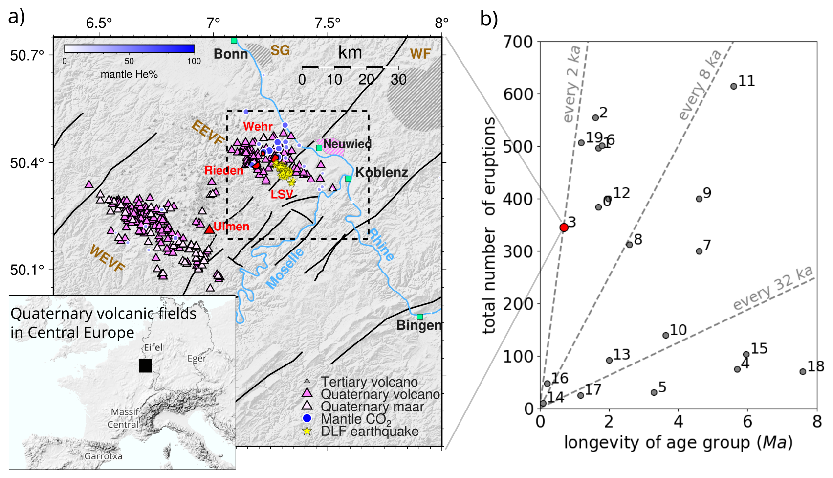
Figure 1(a) Overview of the Quaternary volcanic fields in the Eifel. Emission points for mantle-derived CO2 (yellow diamonds) and He (blue circles) are shown along with major regional faults like the NE-striking Siegen Thrust and sub-parallel faults (black lines). (b) Global assessment of eruptive recurrence intervals for selected distributed volcanic fields in continental settings. 0 is the Harrat Khaybar; 1 is the Northern Harrat Rahat; 2 is the Armenia, 3 is the Eifel Quaternary Volcanic Fields, Germany; 4 is Pancake, USA; 5 is Yucca Mountain, USA; 6 is Springerville, USA; 7 is Camargo, Mexico; 8 is the Klyuchevskoy Group, Russia; 9 is the Newer Volcanic Province, Australia; 10 is Pali Aike, Argentina; 11 is San Francisco, USA; 12 is Pinacate, Mexico; 13 is Coso, USA; 14 is Hurricane, USA; 15 is Lunar Crater, USA; 16 is Sabatini, Italy; 17 is Big Pine, USA; 18 is Cima, USA; and 19 is the Eastern Snake River Plain, USA (compilation from Alohali et al., 2022).
The volcanoes of the Eifel, Germany, are part of the Cenozoic Central European Volcanic Province, which includes many world-class examples of distributed volcanism. Remarkable in global comparison is not only the size of its two Quaternary subfields, comprising the East and West Eifel Volcanic Fields (EEVF and WEVF, respectively), and the number of volcanoes (Fig. 1a) but also their eruptive recurrence, with more than 350 eruptions within ca. 700 kyr (Fig. 1b; see also Schmincke, 2007). The last volcanic eruptions in the Eifel occurred at ca. 13 ka (Reinig et al., 2021; Warken et al., 2025) in the EEVF at Laacher See Volcano (LSV) and at ca. 11 ka (Zolitschka et al., 2000; Preusser et al., 2011) at Ulmener Maar in the WEVF. The Eifel displays a wide range of eruption types. By number, monogenetic scoria cones and explosive maar diatremes predominate in the EEVF and WEVF, whereas repeated eruptions from long-lived volcanic focal points only occurred in the EEVF (Fig. 2a). These produced highly explosive, large-volume eruptions of evolved, gas-rich phonolitic and trachytic magma, with LSV as the youngest of these evolved centres. Carbonatitic intrusions at depth are evident from ejecta clasts (e.g. in the uppermost LSV pyroclastic deposits), whose study has transformed early hypotheses about crustal origins of carbonatites by demonstrating their mantle-like carbon and oxygen isotopic composition (Taylor et al., 1965).
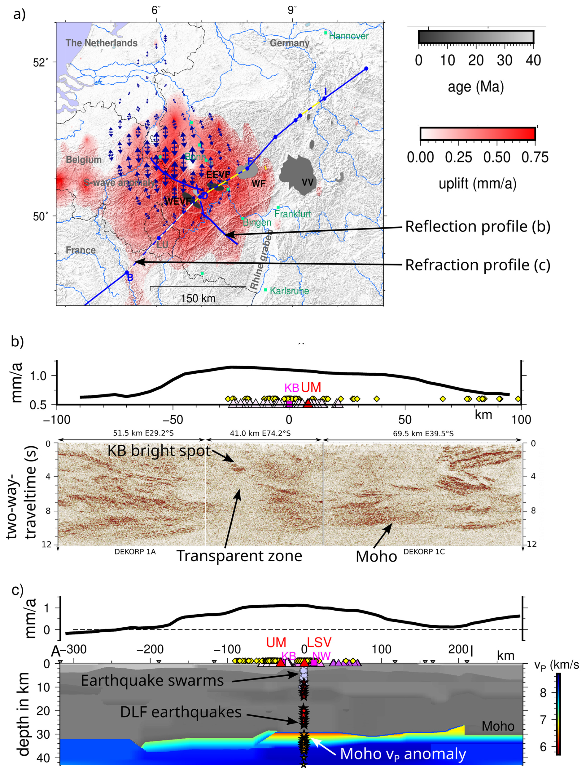
Figure 2Regional uplift and crustal structure of the Eifel. (a) Uplift rate (gridded field) and extension rate (double arrows) derived from dense Global Navigation Satellite System (GNSS) data (data from Kreemer et al., 2020). Blue lines show a steep-angle seismic experiment (DEKORP 1A-1C) and a wide-angle refraction experiment from 1979 (both described in Dahm et al., 2020). Volcanic provinces are indicated by grey polygons. Abbreviations: EEVF denotes East Eifel Volcanic Field, WEVF denotes West Eifel Volcanic Field, WF denotes Westerwald Field, VV denotes Vogelsberg volcano. (b) Uplift rates from the European Ground Motion Service (EGMS, e.g. Crosetto et al., 2020, 2021) are projected over the DEKORP 1 profile of the pre-stack time migration results (two-way travel time versus distance, from Dahm et al., 2020). Projected scoria cones (red triangles) and CO2 springs (yellow diamonds). Positions of the Ulmener maar (UM), Kelberg (KB), the KB bright spot, and the transparent zone in the lower crust are indicated. (c) Uplift rate and refraction seismic P-wave velocities along the wide-angle refraction line. Velocities in the upper mantle are coloured, and velocities in the crust are greyish (from Dahm et al., 2020). Deep low-frequency (DLF) volcanic earthquakes between 2013 and 2022 (stars, updated from Hensch et al., 2019) and earthquake swarms are indicated. As in (b), the projected scoria cones and CO2 springs are projected together with the positions of the UM, KB, and Ulmener maar (UM), Kelberg (KB), Laacher See Volcano (LSV), and the city of Neuwied (NW).
Magmatism in the Eifel is coeval with uplift of the Rhenish Massif but also with local subsidence forming the Neuwied Basin since the Paleogene (Weidenfeller, 2019). Magmas originate in the upper mantle, where a thermal anomaly exists between 50 and 200 km depth that laterally extends over several hundreds of kilometres. This anomaly involves decompression melting in an upwelling asthenospheric mantle (e.g. Ritter, 2007, and references therein), with melt transport from this level being documented by xenolith populations from maar and scoria cone eruptions (Witt-Eickschen, 2007; Trieloff and Altherr, 2007; Seck and Wedepohl, 1983). At the crust–mantle boundary between 30 and 35 km depth, layers with variable amounts of partial melt have been seismically imaged beneath the Eifel volcanic fields (Fig. 2c; Dahm et al., 2020). These layers are only 6 km thick but possibly extend over > 100 km. Seismological data also reveal that, above the near-Moho reservoir, a cone-shaped isotropic zone has overprinted the tectonic and lithological structures in the WEVF (Fig. 2b; Dahm et al., 2020). A potential crystal mush layer in the lower crust is assumed to be affected by repeated small intrusions and fluid–rock interaction. Small batches with high degrees of partial melt can accumulate and evolve at these depths, as indicated from metamorphic xenoliths and barometry of CO2-dominated fluid inclusions (Sachs and Hansteen, 2000).
Previous research demonstrated that CO2 plays a key role in magma origins, transport, and eruption. In the absence of ongoing eruptions in the Eifel, CO2 is an essential tracer for magma pathways extending from the mantle to the surface, with deep low-frequency (DLF) earthquakes being potential indications for ongoing fluid transport at depth (Hensch et al., 2019). Regional gas exhalation is indicated by the distribution of CO2 rich springs. These show elevated 3He 4He isotopic compositions (, with R and Ra representing the 3He 4He ratios of the sample and atmosphere, respectively; Fig. 1a), demonstrating significant mantle-derived volatile contributions to the discharging gases (Fig. 2b; Bräuer et al., 2013). However, the nature and geometry of CO2 transport pathways, ascent velocity, and potential intermittent storage remain obscure (Fig. 2b; Goepel et al., 2015). This also holds for the influence of CO2 degassing at depth during the unfolding of maar–diatreme eruptions, for which it has been recently proposed that CO2 may rival or surpass the influence of near-surface magma–water interaction (e.g. Schmincke et al., 2025). Evidence for cold, CO2-driven diatreme formation breaching the surface (Park et al., 2021, 2023), along with current deformation transients and limnic gas bursts, indicates long-lasting gas recharge into and release from subsurface CO2 reservoirs that pose potential hazards even without direct involvement of magma. Such hazards are currently widely disregarded for the Eifel and elsewhere. Cogenetic carbonatitic intrusive rocks and fenites are present in LSV pyroclastic deposits, as well as in the evolved precursors of the Laacher See eruption at the Wehr and Rieden complexes (Liebsch, 1996; Schmitt et al., 2010). Because these carbonatite ejecta reach critical mineral levels of ∼ 0.25 wt % REE+Y oxide (Liebsch, 1996), well above the global median for carbonatites (∼ 0.08 wt %; n=3604 from the GEOROC database), they provide tangible evidence for magmatic pre-enrichment and hydrothermal redistribution of critical elements in the LSV magma plumbing system. While this underscores that LSV is a unique test bed for studying transport and sequestration of critical metals, the structural context and source depth of these lithic fragments derived from the silicate–carbonatite intrusives and their fenitic aureole can presently can be indirectly inferred only.
This review lays out the reasons why scientific drilling is an essential component in a comprehensive approach to decipher the actual status of lithosphere-scale magmatic systems underneath the Eifel and why it is ultimately necessary to develop quantitative models for its future volcanic evolution. In three recent workshops, fundamental research questions about distributed volcanic fields were defined, where drilling can uniquely provide answers. All known eruptions in the Eifel occurred in prehistoric times in a now highly developed region, offering outstanding accessibility and an excellent infrastructure that is especially suited for scientific drilling. By the same token, a dense and technology-dependent population is vulnerable to even small-scale disturbances, calling for better constraints on volcanic hazards for the region at all scales and levels of interconnectedness. On the one hand, results from drilling will be augmented by the excellent geological, geophysical, petrological–geochemical, and volcanological data that have been acquired in more than 200 years of research in the area. On the other hand, drilling is key to test hypotheses for many ongoing research activities, and it will open new avenues for transdisciplinary research and synthesis. Drawing on the workshop outcomes, this contribution reviews the knowledge base for future drilling, summarises the main interdisciplinary discussions, synthesises the resulting research objectives, and presents a two-phase drilling strategy: Phase 1 into the near-surface subvolcanic realm and Phase 2 into the deeper magmatic–hydrothermal system overlying the upper-crustal silicate–carbonatite complex that fed the ca. 13 ka Laacher See eruption.
2.1 Constraints from the study of previous eruptions
Chronostratigraphic investigation has established that volcanism in the EEVF (Fig. 3) was initiated at the Rieden centre (ca. 460–430 ka), followed by migration towards the southeast, which led to the formation of basanitic–tephritic scoria cones and maars at and after ca. 215–190 ka (Schmincke, 2007). Evolved (trachyte and phonolite) magmas then erupted from the Wehr centre and from Dümpelmaar until 99 ± 4 ka (Sturm et al., 2024). To date, the culmination of volcanic activity in the EEVF has been the VEI (volcanic explosivity index) 6 eruption of LSV at 13 ka, as constrained by tree-ring-correlated 14C (Reinig et al., 2021) and speleothem U-series dating (Warken et al., 2025). At the time of the cataclysmic LSV eruption, an interconnected, thermally and compositionally stratified phonolitic magma reservoir existed (Wörner and Schmincke, 1984; Tomlinson et al., 2020). During the late stages of the LSV eruption, small quantities of basanite scoria were vented, indicating mafic recharge into the system with magma-mingling timescales of less than 400 d before the eruption (Sundermeyer et al., 2020). Geochemical and petrological studies constrain the uppermost level of the translithospheric magma system in the EEVF to 3–4 km (115–145 MPa pressure; Berndt et al., 2001), consistently with depth estimates for evolved magma reservoirs at 3–7 km from contact metamorphic xenoliths (e.g. Wörner et al., 1982). Detailed studies of diffusion modelling of zoned feldspar reveal that the intrusive complex remained hot (> 560 °C; see Rout and Wörner, 2018, 2020) over several tens of thousands of years preceding the eruption (Fig. 3d), with these durations being constrained by U-series geochronology (Bourdon et al., 1994; Schmitt et al., 2010). Maintaining the elevated temperatures indicated by diffusion modelling over the durations recorded by zircon geochronology requires frequent influx of fresh magma to maintain elevated temperatures in the magma system. Evolved alkaline volcanism in the EEVF is associated with the ejection of cogenetic carbonatite clasts dating to several tens of thousands of years prior to eruption (Fig. 3d). These originate from subsurface carbonatite intrusions (Liebsch, 1996; Schmitt et al., 2010; Berndt and Klemme, 2022) that likely segregated via liquid immiscibility in the most evolved shallow parts of the LSV phonolite reservoir (Fig. 4). Mantle-derived CO2 also plays an important role in controlling crystal melt stability in magma reservoirs, and the flushing of crystal-rich mush reservoirs by the arrival of large amounts of ascending CO2 has been proposed as an eruption trigger for comparable volcanoes (Caricchi et al., 2018; Pappalardo et al., 2022). Whether CO2 flushing prior to the LSV eruption played a role remains unclear (Sundermeyer et al., 2020). Moreover, it is unresolved how ongoing degassing is related to the residual silicate–carbonatite intrusive complex or possibly newly accumulated mafic magma in the upper crust underneath Laacher See. Intriguingly, fossil silicate–carbonatite systems of similar composition to those ejected from Laacher See and other evolved EEVF centres are known to sometimes form world-class ore deposits for critical elements, among which rare earth elements (REEs) stand out prominently (e.g. Bayan-Obo, China; Mt. Weld, Australia). This also includes REE mineralisation at Songwe Hill (Malawi), which are the target for the International Continental Scientific Drilling Programme (ICDP) project REEDRILL (https://www.icdp-online.org/projects/by-continent/africa/reedrill-malawi/, last access: 30 January 2026).
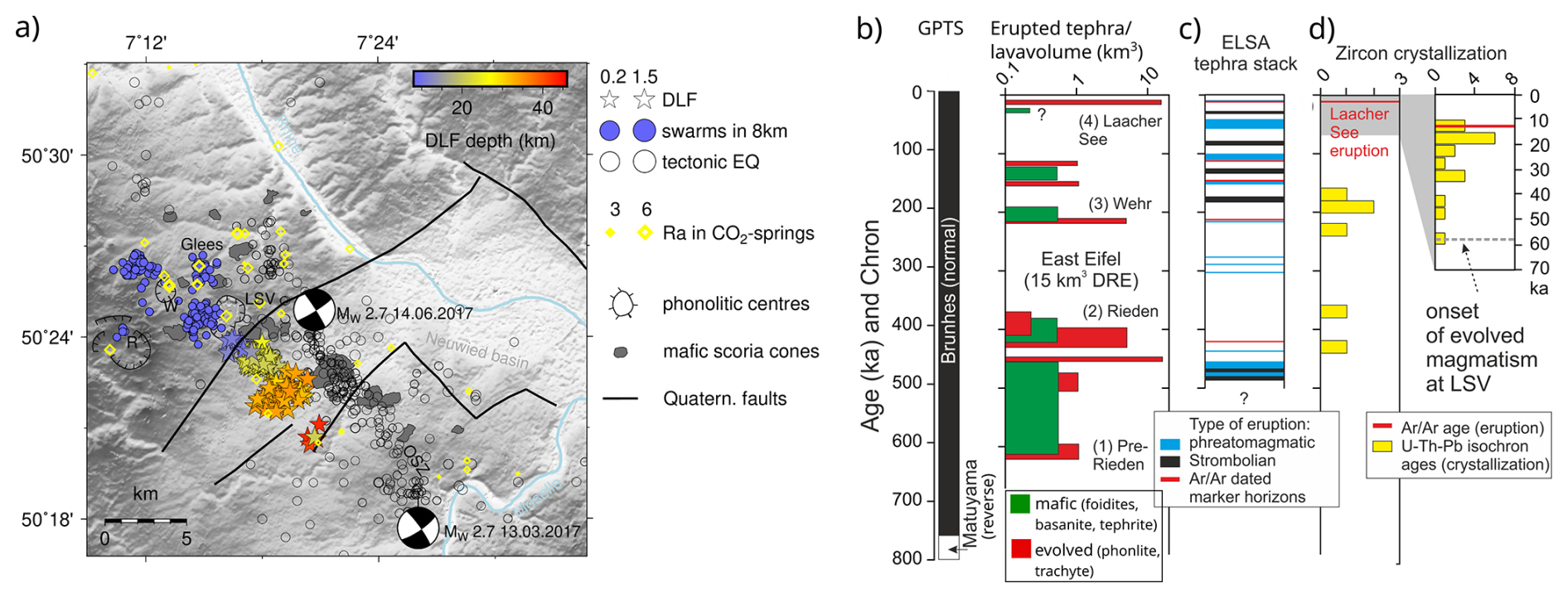
Figure 3(a) Earthquake activity between 2013 and 2022 in the EEVF (dashed box in Fig. 1), showing tectonic earthquakes, swarm-like micro-earthquakes at 8 km depth beneath the phonolitic-trachytic centres, and deep low-frequency (DLF) earthquakes. The two focal solutions in the Ochtendung seismic zone (OSZ) indicate left-lateral strike–slip movement (from Hensch et al., 2019). Boundary faults of the Neuwied Basin (the NW boundary is the Siegen Thrust) are indicated by lines, and 3He 4He isotope ratios () of CO2 degassing sites are indicated by yellow diamonds (Bräuer et al., 2013). (b) Compilation of eruption ages and volumes of mafic and evolved products for the EEVF (Schmincke, 2007, and references therein) in comparison to the Geomagnetic Polarity Time Scale (GPTS), (c) the Eifel Laminated Sediment Archive (ELSA) for tephra intercalated with lacustrine sediments cored in maar lakes (Förster et al., 2020, and references therein), and (d) zircon crystallisation ages recording magma differentiation at depth prior to eruption (Schmitt et al., 2010, 2017) in comparison with 40Ar 39Ar ages dating the eruption.
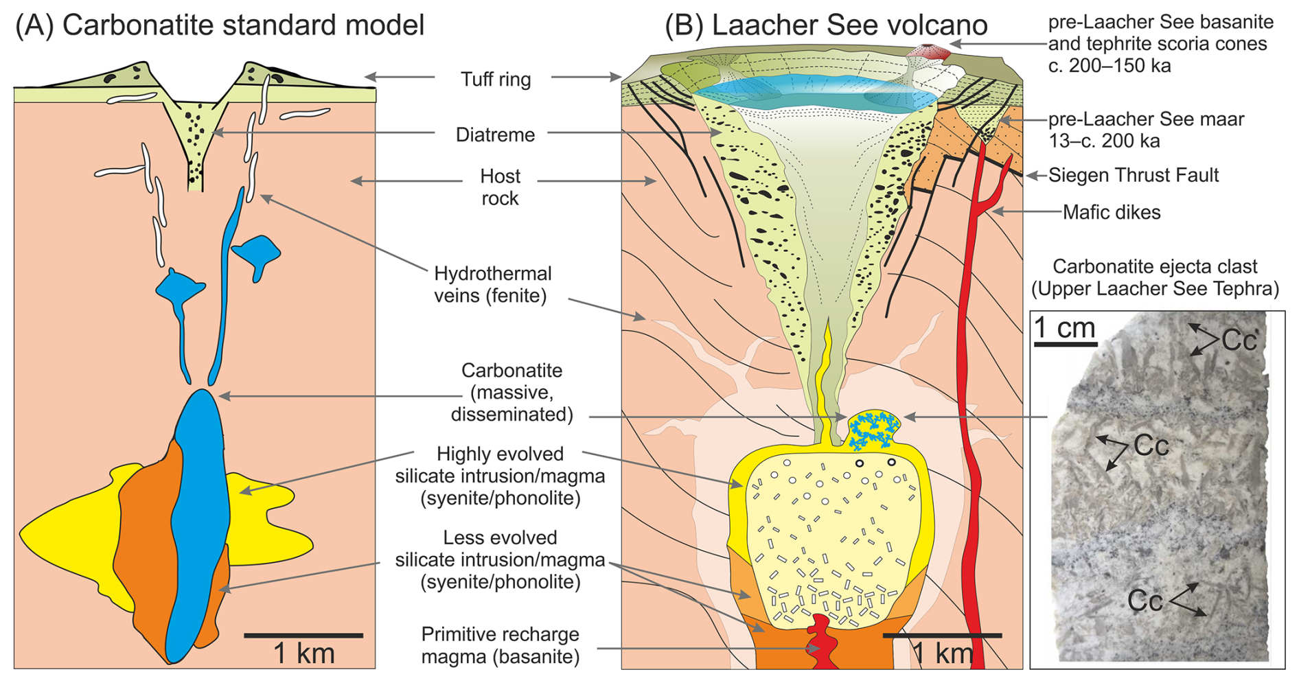
Figure 4Comparison of (a) the standard model for carbonatite intrusions and their volcanic overburden (after Pirajno and Yu, 2022) and (b) the silicate–carbonatite magma reservoir of Laacher See with its plutonic margins as inferred from the study of carbonatite ejecta clasts shown as a photomicrograph of a polished rock section (Cc denotes calcite; arrows point to selected calcite blades in different parts of a layered or veined carbonatite) (after Schmitt et al., 2010; Sundermeyer et al., 2020).
2.2 Recent geophysical and geodetic observations
Recent geophysical and geodetical observations have challenged preconceptions regarding the deep structure of the Eifel volcanic fields. Degassing from stalled magma at Moho depths with ongoing migration of magmatic fluids through the crust beneath the EEVF is the likely cause of the occurrence of DLF earthquakes in persistent depth clusters (Hensch et al., 2019). The first DLF earthquakes were detected in 2013, and, since then, several deep clusters have been active, indicating a subvertical channel structure between 10 and 45 km depth, through which CO2-rich fluids and/or melt migrate upwards. This transcrustal channel coincides with the location of the highest CO2 fluxes and most elevated values in the region between Wehr and Laacher See, close to the village of Glees (Fig. 3a). Local earthquake tomography reveals an enhanced ratio and reduced vP velocity beneath LSV (Zhang et al., 2026). For the LSV precursor centres, a velocity anomaly is also resolved beneath the older Rieden complex at 8 km depth, whereas it appears to be absent beneath the younger Wehr complex (Zhang et al., 2026). Overall, these seismological observations correlate well with the depth estimates for the pre-eruptive reservoirs of LSV and other evolved complexes postulated from petrological data. Today, the LSV anomaly is cylindrical, with a diameter of ∼ 3 km. It dips by about 53° towards S–SE and reaches a depth of ∼ 10 km. The present-day geometry and depth are further confirmed by 3D gravity inversion, which reveals a density deficit of 100 kg m−3 down to at least 9 km depth (Mohamad Sobh, personal communication at CVO-workshop, GFZ Potsdam, 2025). Since swarm-like microearthquakes occurred between and below all three centres at a depth of ∼ 7 km in 2017–2018, 2022, and 2025 (Fig. 3), including within the LSV anomaly, it can be assumed that CO2 or melt influx continues to this day. A potential example of the geometry of a former sill- or saucer-type magma reservoir is present in the Hocheifel beneath Kelberg (see Dahm et al., 2020), where seismic profiling resolved a 10 km wide bright spot between 6 and 10 km depth, which correlates with a circular magnetic and gravity anomaly. This anomaly is interpreted to be the remnant of a magma reservoir that relates to a prominent centre of Paleogene volcanism in the Hocheifel region, which also exposes evolved (trachytic) stocks (Fekiacova et al., 2007).
Ongoing regional-scale uplift of the Rhenish Massif (e.g. Kreemer et al., 2020) is identified in GNSS and Persistent Scatterer Interferometric Synthetic Aperture Radar (PSInSAR) 10- or 20-year average velocities. Interestingly, the surface uplift rate correlates with the intensity of the Moho velocity anomaly and the smooth Moho upwelling over distances of more than 100 km (Fig. 2c). The uplift rate also peaks where Moho upwelling is indicated in a seismic profile through the Eifel (DEKORP 1A-1C), along with a lower crustal seismically transparent wedge in the lower crust (Fig. 2b). To improve monitoring capabilities and modelling accuracy, 20 continuous GNSS stations were installed between 2022 and 2024 in the East Eifel region (see https://research-infrastructure.gfz.de/de/, last access: 30 November 2025). As of 2025, the GNSS stations on a larger scale show mostly slight subsidence and horizontal motion, indicating possible contributions from the deeper reservoir system (Zhiguo Deng, GFZ, personal communication, 2025).
Seismological receiver function analysis from a large-N deployment in 2022–2023 revealed strong upwellings of the crust–mantle boundary (Moho) and the lithosphere–asthenosphere boundary (LAB) beneath the EEVF (Xiaohui Yuan, GFZ, personal communication, November 2025). These upwellings rise to depths of 28 and 40 km beneath the Neuwied Basin south of LSV. The highest upwelling peaks intersect with the trace of volcanic DLF earthquakes, connecting the LAB with the evolved upper crustal reservoir of LSV. This experiment also reveals significant S-to-P reflections at depths between 29 and 22 km beneath the Neuwied Basin (Dahm et al., 2025), indicating potential sill reservoirs in the lower crust. Local earthquake tomography (Zhang et al., 2026) and older reflection seismic profiles (Dahm et al., 2020) indicate over-thrusting layers in the hanging wall of the Siegen Thrust system down to about 12 km depth, which seem to control CO2 and magma ascent from depth and the possible ponding of fluids.
2.3 CO2-driven diatreme formation as precursors to the Laacher See eruption
The hydrothermal systems above the upper crustal reservoirs in the EEVF likely evolved over the same timescales as indicated by the presence of evolved melts and the datable accessory mineral zircon crystallised from them (e.g. ca. 50 ka in case of LSV; Fig. 3). At the surface, these systems are presently characterised by diffuse CO2 degassing from distributed mineral springs and mofettes (Fig. 3). Continuous measurements of physical and chemical variations in these mofettes only started in 2021, also motivated by occasional eyewitness reports of episodic gas bursts in the Laacher See water body (e.g. 15 August 2022 by Andreas Becker, Landesamt für Vermessung und Geobasisinformation Rheinland-Pfalz) and some historical reports on possible limnic eruptions (e.g. by 1 July 1844, cited in Giornale del Regno delle Due Sicile, 3 August 1844, no. 163, p. 651).
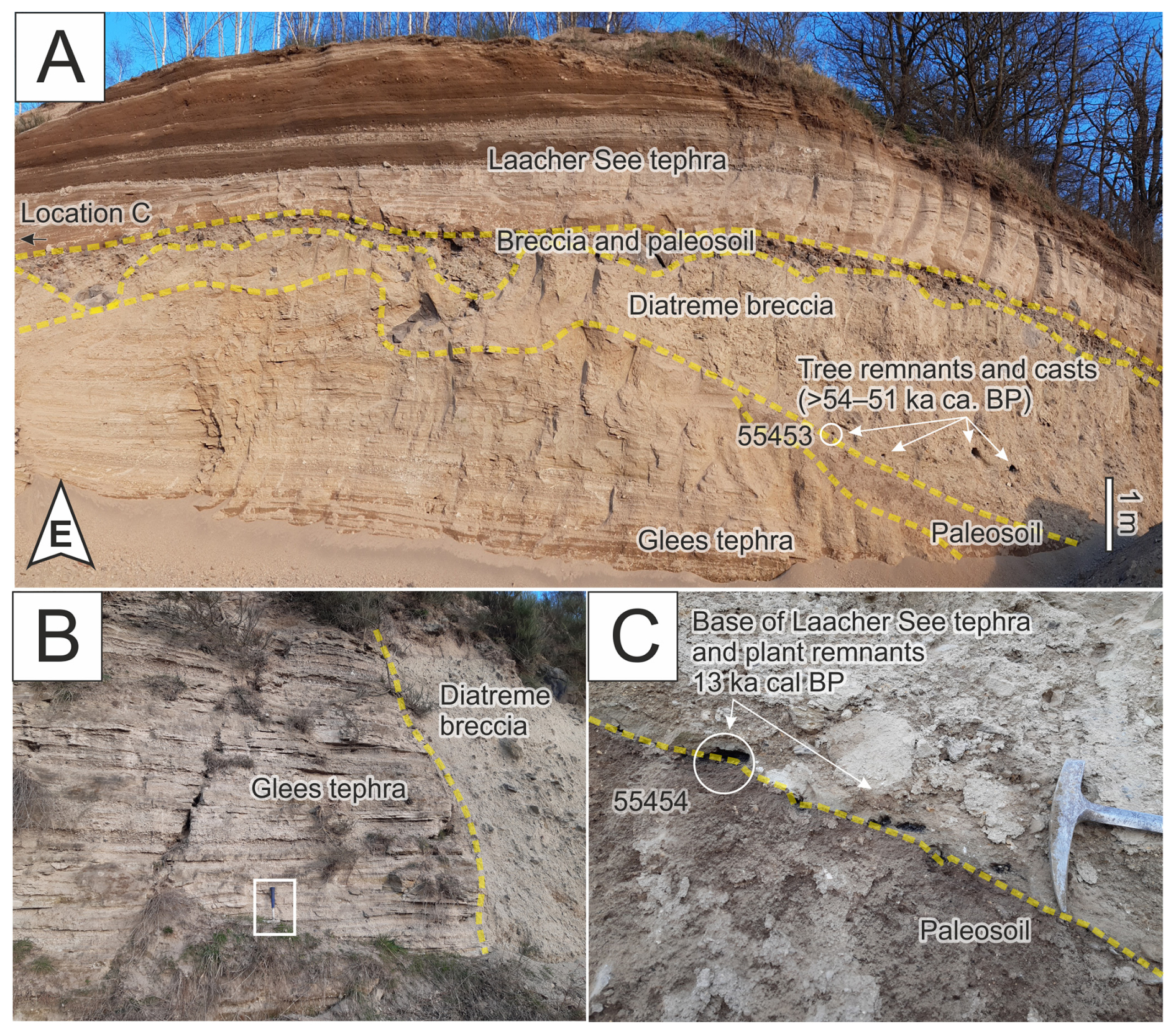
Figure 5Overview of exposure on top level of Rick quarry, Glees, east-facing wall (A). Layered Glees tephra with paleosol overlain by diatreme breccia with tree casts and clast-rich breccia with variable thickness. Stratigraphically highest unit is Laacher See tephra (MLST; Park et al., 2021). (B) Glees tephra bed laterally truncated by diatreme breccia; picture is taken on same quarry wall ∼ 100 m north of panel (A). Close-up of contact between breccia, brown paleosol and overlying Laacher See deposits with charred plant remnants (C); picture location immediately south of panel (A). 14C sampling locations (circles) and ages for the corresponding sample types are indicated (arrows) (Table 1).
Table 1The 14C age results for charcoal in the section exposing diatreme breccia (Rick Quarry, east-facing wall). Sample 22-Glees-C1 is from a ∼ 10 cm charred tree trunk sampled ∼ 0.25 m above the contact between diatreme breccia and the underlying Glees tephra with a paleosol, whereas 22-Glees-C2 was collected above clast-rich breccia and paleosol directly underlying Laacher See tephra. Ages are in years before present (yr BP relative to 1950 CE). The δ13C value is stated at ∼ 2 ‰ uncertainty and is only used for fractionation correction.
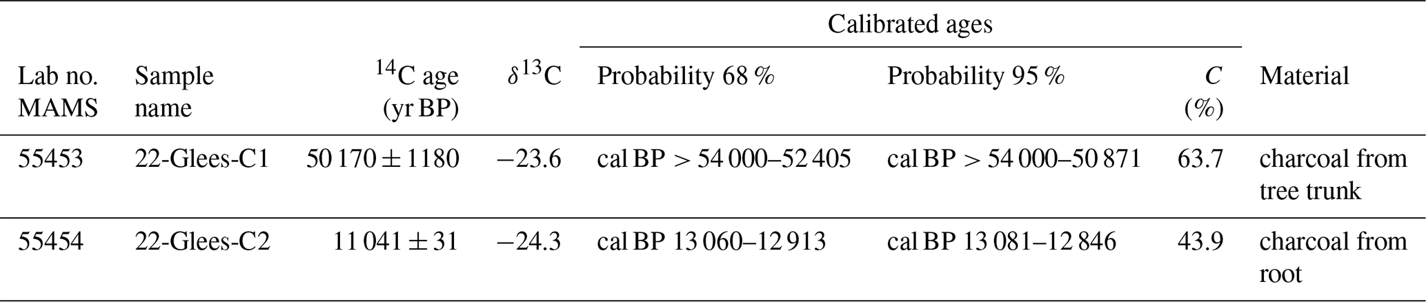
Based on mapping along the western slope of the Veitskopf scoria cone, which is located northwest of the Laacher See and truncated by the crater, potentially CO2-driven explosive events have recently been recently identified by Park et al. (2021, 2023). Based on the relative timing of diatreme eruptions as indicated by clast componentry and stratigraphy (Park et al., 2021, 2023), these may represent precursor events related to the ancestral LSV or possibly related to the precursor Wehr system. Diatreme breccia components include large clasts of Devonian shale and basanitic lava, as well as basanite and phonolite tephra clasts derived from underlying volcanic deposits; these lithoclasts are vertically aligned, indicating the direction of movement (Park et al., 2021, 2023). Also present are remarkably large (1 m long and ∼ 30 cm in diameter; Fig. 5) aligned tree trunks near the base of the breccia deposits. Layered Glees tephra with a mature paleosol on top is dissected by diatreme breccia (Fig. 5). It is also overlain by breccia deposits with variable thickness and with irregular contact surfaces, suggesting infilling of steep topography (Fig. 5). In addition to the tree trunks, there are also charred plant remnants which occur along the boundary between breccia and overlying LSV deposits (Park et al., 2021, 2023). New chronostratigraphic constraints are derived from the 14C geochronology of these organic materials (Table 1; this study). In accordance with outcrop stratigraphy, the terminal diatreme breccia deposition occurred prior to 13 ka, whereas the tree trunk minimum age of ca. 51 ka is at the limit of the 14C method (Table 1). Thus, early diatreme activity after the Glees eruption (112 ± 3 ka; Sturm et al., 2024), allowing for some intermittent weathering and soil formation, could have occurred late during the penultimate interglacial (cf. Park et al., 2021). The spatial extent of multiple diatremes identified in the Glees area (Park et al., 2021, 2023) and potential genetic links with the evolving LSV magma system are still incompletely resolved. Where, when, and how these diatremes formed and whether they were precursor events prior to the Laacher See eruption are important questions because of hazard implications related to explosive venting in areas of active CO2 degassing.
3.1 Workshop organisation and participation
Three workshops were conducted to develop research questions and to enhance collaboration. The first workshop, funded by the Journées Luxembourgeoises de Géodynamique, was realised between 5 and 7 September 2022 in Luxembourg with more than 60 participants from five countries. The second science workshop, funded by ICDP, was organised between 4 and 6 December 2023 in Bad Honnef, Germany. A total of 80 participants from 10 countries participated. Key questions and drilling strategies were discussed, leading to the strategy of two-phase shallow and deep drilling. Other workshop topics included the technical feasibility of drilling and integration with ongoing research activities in the Eifel. During a 1 d field trip to the Laacher See region led by the late volcanologist Hans-Ulrich Schmincke and logistically supported by the German Volcanological Society (DVG), the ICDP workshop participants visited key outcrops. Locations visited comprised the Wingertsbergwand geosite (Fig. 6), exposing the LSV eruptive tephra sequence as an inversion of the pre-eruptive layered magma reservoir; a mofette at the lake shore; and the Glees diatreme within pre-LSV deposits at the Rick Quarry. A last hybrid workshop was held on 27–28 March 2025 in Potsdam, which involved the core proposal-writing team to discuss the specific drill sites of Phase 1.
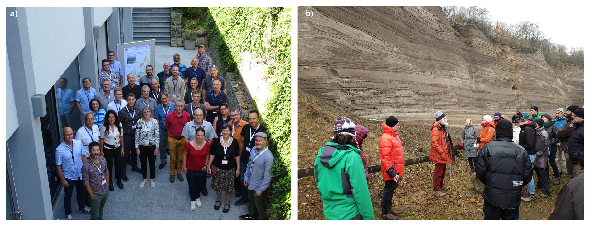
Figure 6(a) Participants of the first workshops between 5 and 7 September 2022 in Luxembourg. (b) Field trip during the second workshop from 4 to 6 December 2023 in Bad Honnef, Germany. Hans-Ulrich Schmincke explains the structure of the Wingertsbergwand near the village of Mendig.
3.2 Research priorities for scientific drilling in the Eifel
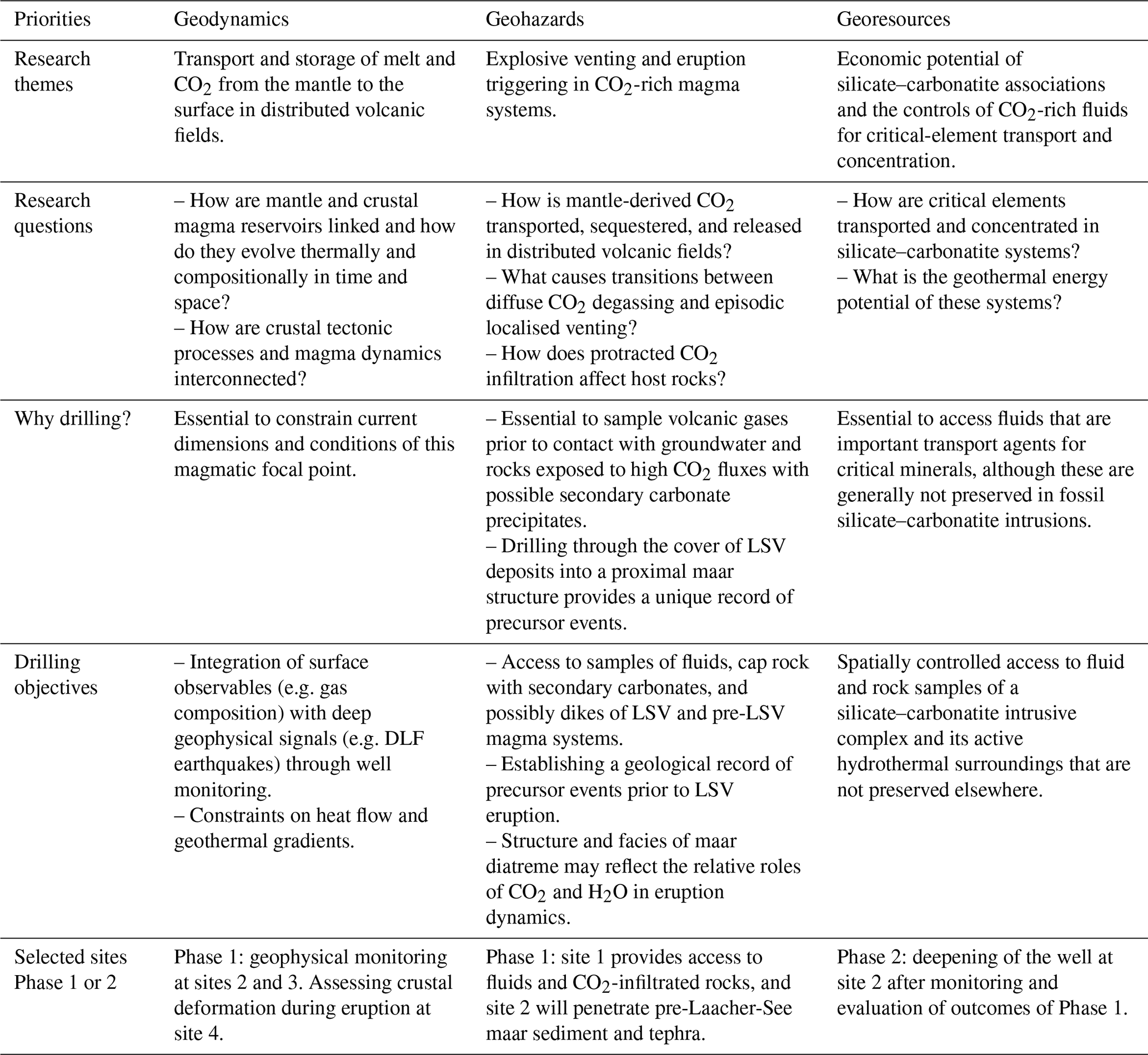
The need for scientific drilling as an essential tool to develop quantitative concepts about magma origins, transport, storage, and venting in distributed volcanic fields was universally recognised by workshop participants. The Eifel as the type location for explosive maar volcanism is of global relevance for developing and testing concepts about low-degree mantle melting in continental intraplate settings. Research priorities match three of the four ICDP science themes for 2020–2030, namely geodynamic processes, geohazards, and resources.
-
Geodynamic processes. The Eifel hosts a wide range of magma compositions, including extremely SiO2-undersaturated melilitite and nephelinite, as well as alkaline series magmas including basanite, tephrite, trachyte, and phonolite. The associated volcano types include scoria cones, maars, and caldera depressions, ranked in terms of increasing explosivity. While it has long been ascertained that parental magmas in these systems form by continuous small-degree melting in the upwelling upper mantle, it remains unclear why, when, and how magma ponds in intermittent storage reservoirs in the upper mantle and crust. Intriguingly, evolved (trachyte, phonolite) centres only formed in the EEVF, whereas such magma types are exceedingly rare in the WEVF, although syenitic plutonic ejecta that formed as intrusive differentiates are occasionally present as lithic clasts in primitive scoria cone deposits (Schmitt et al., 2023). Uncertainties about intracrustal magma storage vs. direct melt ascent also limit the interpretation of geophysical evidence for transcrustal fluid transport as indicated by DLF earthquakes in the EEVF. Degassing, especially of CO2, that is associated with melting, magma ascent, and crystallisation is another important geodynamic factor. It is not only the case that passive degassing could represent an underestimated contribution to global volcanic CO2 emissions; CO2 also has the potential to critically influence magma evolution and eruption style, key parameters for hazard assessments. The ongoing magmatic underplating at the Moho and unrest in the lower and upper crust, as well as in the shallow hydrothermal system, are evident in the EEVF on multiple spatial and temporal scales, identifying this region as an ideal study site. Because of the highest 3He 4He values and the observed deformation transients within a potential focal zone for evolved volcanism, a region northwest of LSV near the village of Glees is particularly intriguing for scientific drilling. This could answer critical questions in a two-phase approach, where progressively deeper levels and components of a composite transcrustal magma system could be sampled. Unique insights of global relevance include the fact that drilling in the Eifel could produce a range of benefits, from improved geophysical monitoring (heat flow, seismicity, CO2 flux) to in situ sampling of trapped fluids or even melt (e.g. Elders et al., 2011).
-
Geohazards. Many population centres are exposed to volcanic hazards associated with distributed volcanism (e.g. Auckland, New Zealand; Chaine de Puys, France; Medina, Saudi Arabia). Large-volume evolved centres such as LSV, however, have not emerged in all of these fields. Intriguingly, for the Eifel, they only exist in the EEVF and not in the WEVF despite both fields being broadly coeval and occurring in a similar tectonic setting. Nonetheless, explosive phonolitic volcanism as represented by LSV and its precursor volcanoes Wehr and Rieden represents a major hazard in many places (e.g. Changbaishan, China/North Korea; Phlegrean Fields, Italy; Puy de Dome, France). Due to the scattered location of vents in the Eifel and many other distributed volcanic fields, CO2-related volcanic hazards may also have been overlooked. This is particularly relevant for CO2-driven diatreme formation and CO2 as a trigger for explosive eruptions. Better constraints on these processes can be derived from scientific drilling in the Eifel by reconstructing potential precursor events related to the Laacher See eruption, identifying pathways of CO2 transport, constraining the interaction of CO2 with water and rock, and refining eruption dynamics from the structures and facies of maar diatremes. In the long term, methods and technologies developed within the anticipated ICDP research project may form the basis for new hazard assessment and risk mitigation strategies in active, distributed volcanic provinces worldwide. The multiparametric datasets acquired through this project will be integrated into community initiatives and infrastructures, such as the European Plate Observing System (EPOS). EPOS aims to promote the use of these datasets to advance multidisciplinary science and to develop new Earth models. The ICDP Eifel research will also contribute directly to the planned virtual and distributed Eifel Volcano Observatory that was initiated at the Bad Honnef workshop.
-
Resources. Carbonatites are rare igneous rocks containing substantial amounts of carbonate minerals, and carbonatitic plutonic ejecta clasts are present in the uppermost LSV pyroclastic deposits (Taylor et al., 1965; Liebsch, 1996; Schmitt et al., 2010). As the primary resource for the REEs required for permanent magnets in electrical generators and engines, they are economically important in the transition to a zero-emission economy. Carbonatites are typically emplaced away from established plate boundaries and occur in continental intraplate settings, rift zones, and subordinately oceanic islands (Pirajno and Yu, 2022; Yaxley et al., 2022). About three-quarters of 600 known carbonatite occurrences worldwide are associated with alkaline silicate rocks (Yaxley et al., 2022), similar in composition to EEVF phonolite (Fig. 4). Although there is agreement that most carbonatite magmas and their potential precursors are mantle derived, the common association between carbonatite and silicate rocks remains unresolved. Different processes are controversially discussed, including direct production of carbonatite melts in the mantle, liquid immiscibility in a carbonated silicate melt upon differentiation, and fractional crystallisation of a CO2-rich silicate melt to a residual carbonatitic liquid (Pirajno and Yu, 2022; Yaxley et al., 2022). One key characteristic that makes drilling at Laacher See complementary to the study of fossil silicate–carbonatite intrusions is that, because of its young age, metal transport and deposition processes can be studied in a state of ongoing formation. Sampling of gases and fluids from an active system could provide insights from which the study of older carbonatites will benefit. Conversely, processes that are known to redistribute REEs, such as weathering, can be disregarded for rocks in the subsurface of LSV. Hence, the timing and evolution of CO2-rich alkaline melts and fluids can be investigated at LSV without complicating factors such as metamorphic overprinting, weathering, or erosion, which typically compromise the study of older carbonatites.
The possibility of direct sampling of fluids degassing from and circulating above a young phonolite–carbonatite magma reservoir through scientific drilling is thus a unique opportunity. Although temperatures above the LSV magma system are likely to be much lower than for active volcanoes in Iceland, the prospect of encountering mineralising fluids associated with a late Pleistocene–Holocene subvolcanic intrusive complex is of significant scientific relevance, similar to that of sampling high-enthalpy geothermal fluids and melt during the Krafla Magma Testbed drilling (Eichelberger et al., 2018). This would also perfectly complement the ICDP project REEDRILL, which targets the REE-mineralised Songwe Hill alkaline–carbonatite complex in Malawi (https://www.icdp-online.org/projects/by-continent/africa/reedrill-malawi/). Because this complex is Late Jurassic–Early Cretaceous in age, in situ sampling of mineralising fluids is impossible, whereas deep drilling at LSV has potential to reach the levels of magmatic fluid circulation, thus providing important complementary information about the physical and chemical conditions in alkaline hydrothermal systems producing fenites around silicate–carbonatite intrusions.
3.3 Workshop research questions
Defined by the thematic framework of ICDP research priorities, workshop participants met in breakout groups and prioritised a list of research questions that apply to distributed volcanic fields as represented by the Eifel. There was unanimous consensus that drilling in the EEVF carries tremendous potential for progress in answering a wide range of pressing research questions. While the EEVF offers many benefits compared to other locations, including accessibility, infrastructure, and a large body of prior research, it was also emphasised that lessons learned from the EEVF will be broadly applicable to similar magmatic systems worldwide (Fig. 1). Key research questions were grouped according to the ICDP priorities as follows.
-
The first questions relate to transcrustal magma transport and storage in distributed volcanic fields (geodynamic processes):
-
How do mantle and crustal magma reservoirs evolve thermally and compositionally within regions of broadly distributed volcanism?
-
How are crustal tectonic processes and mantle upwelling related and is there a link between extension and basin evolution and the focusing of intrusive activity into evolved magmatic systems?
-
Where does CO2 as a separate phase originate and how is it transported, stored, and released at the surface?
-
What is the role of carbonatites and fluid-precipitated carbonates for sequestering CO2 released from degassing magma?
-
What is the geometry and current state of the Laacher See magma reservoir and why are there no geothermal surface manifestations despite its young age?
-
-
The next questions relate to volcanic hazards of CO2-rich magma systems (geohazards):
-
Is CO2 influx responsible for the currently observed low-frequency earthquakes and the past triggers of volcanic eruptions?
-
What causes the transitioning between diffuse CO2 degassing and punctuated venting (e.g. gas bursts or diatreme formation)?
-
How does mantle-derived CO2 interact with groundwater?
-
How do we build more robust models for physical processes in volcanic systems with protracted eruptive recurrence to extend warning times and to mitigate risks?
-
How do we improve assessments for the immediate threat of different styles of volcanism and seismicity in distributed volcanic fields?
-
-
Economic potential of silicate–carbonatite associations (resources):
-
How are critical elements transported and concentrated in silicate–carbonatite magma systems and their hydrothermal surroundings?
-
How does protracted circulation of CO2-rich fluids affect the physical and chemical properties of the host rocks around silicate–carbonatite magma system?
-
How can we access and sustainably harness geothermal fluids associated with shallow magmatic intrusions as energy and critical metal resources?
-
What is the geothermal energy potential of distributed volcanic fields and how can technology be enhanced for high-temperature deep drilling in such systems?
-
To tackle these research questions, integration of multiple disciplinary methods is essential, including those from geochemistry, geochronology, geology, geophysics, geodynamics, petrology, structural geology, and volcanology. Examples for integrating these methods include quantitative modelling of CO2 degassing from alkaline magmas from the mantle source to the surface by combining experimental petrology and gas geochemistry or assessing the depths of magma storage in past eruptions from mineral and inclusion geochemistry combined with seismological evidence for ongoing fluid transport. Multi-scale research also succeeded in deciphering how past eruptions in the Eifel and elsewhere unfolded. This includes macroscale volcanological investigation into the erupted deposits, as well as chronostratigraphy using advanced radiometric dating tools. In parallel, microscale petrological analysis can determine relative timescales of the thermal and chemical evolution of magma prior to eruption from the crystal record. Diffusion chronometers can resolve pre-eruptive processes in the magma over timescales of days to weeks, similarly to those over which geophysical data are collected around volcanoes. Melt inclusion studies can reveal pre-eruptive volatile abundances in the magma, which, in turn, can inform laboratory experiments on volatile solubility and phase saturation. These examples illustrate that concerted efforts are promising for addressing the research questions above, where drilling can provide essential input for ground-truthing laboratory, field, and remote sensing data. To facilitate such multidisciplinary collaborations and to optimise resources for identifying drilling targets, workshop participants favoured a two-phase strategy, where shallow (∼ 300–2000 m) drilling and complementary research on drill samples along with geophysical monitoring in Phase 1 would provide the necessary framework to successfully penetrate the intrusive system of LSV by means of deeper and more expensive drilling proposed for Phase 2 (∼ 3000–4000 m).
3.4 Workshop outreach and societal considerations
During the workshops, various aspects of public outreach and scientific education were discussed. Giuseppe De Natale (Osservatorio Vesuviano) was invited to present on the Campi Flegrei Deep Drilling Project (CFDDP) and to share his experiences in establishing dialogue between scientists working to advance the understanding of volcanic hazards and members of the public, political representatives, and the media. A major challenge in this dialogue is to address public concerns about perceived hazards from scientific drilling in volcanically active areas while still acknowledging and respecting legitimate safety concerns. One important lesson for conducting drilling in a populated area is the need to ensure that citizens and officials feel that their concerns are genuinely heard and that scientists communicate their plans in a clear, accessible, and transparent manner while respectfully dispelling irrational and unfounded fears.
In this spirit, the workshop organisers have been in close contact with the DVG based in Mendig. This local-interest group was founded in 1987, inspired by the late volcanologist Hans-Ulrich Schmincke (Fig. 6), to foster interest and education about volcanism in the Eifel and elsewhere. During the second workshop's field trip, members of the DVG kindly provided logistical support. Furthermore, public talks by geoscientists involved in the workshops have attracted broad audiences, and we plan to expand these efforts in coordination with the DVG and other stakeholders in the future. We anticipate that shallow drilling during Phase 1 will be broadly accepted by the public as the targeted depths are comparable to those of commercial wells already present in the region. Furthermore, the local population generally views the region's volcanic heritage as an economic asset, particularly through quarrying and tourism (e.g. the Lava Dome in Mendig as a volcano-themed museum). This context offers valuable opportunities to implement educational activities in schools and museums before, during, and after the proposed drilling.
4.1 A two-phase strategy for scientific drilling at the Laacher See volcano
The overall objectives of a scientific drilling proposal targeting the EEVF and LSV are to advance quantitative knowledge about distributed volcanic fields in intracontinental settings. Many aspects regarding the extent of these fields, their vent structures, and the geometry of superficial dike swarms, as well as the timing of eruptive activity, eruption recurrence, and styles, remain poorly constrained. By focusing on the role of CO2, both in shallow hydrothermal systems and as a key player controlling physical and chemical magma properties, we can improve existing concepts about the processes involved in translithospheric magma transport and storage. In addition, long-lived hydrothermal systems flushed by CO2 are natural labs to investigate physical, chemical, and mineralogical processes within the host rocks that are potentially relevant for CO2 sequestration. Importantly, drilling is essential to bridge near-surface observations (e.g. degassing, volcanic structures, and deposits) with geophysical and petrological insights into processes in the magmatic plumbing system within the crust and upper mantle. This fundamental knowledge will not only help to better quantify hazards of distributed volcanism but will also be an important step towards volcano engineering and other geotechnical applications, including the potential use of geothermal energy, the extraction of critical elements, and CO2 sequestration.
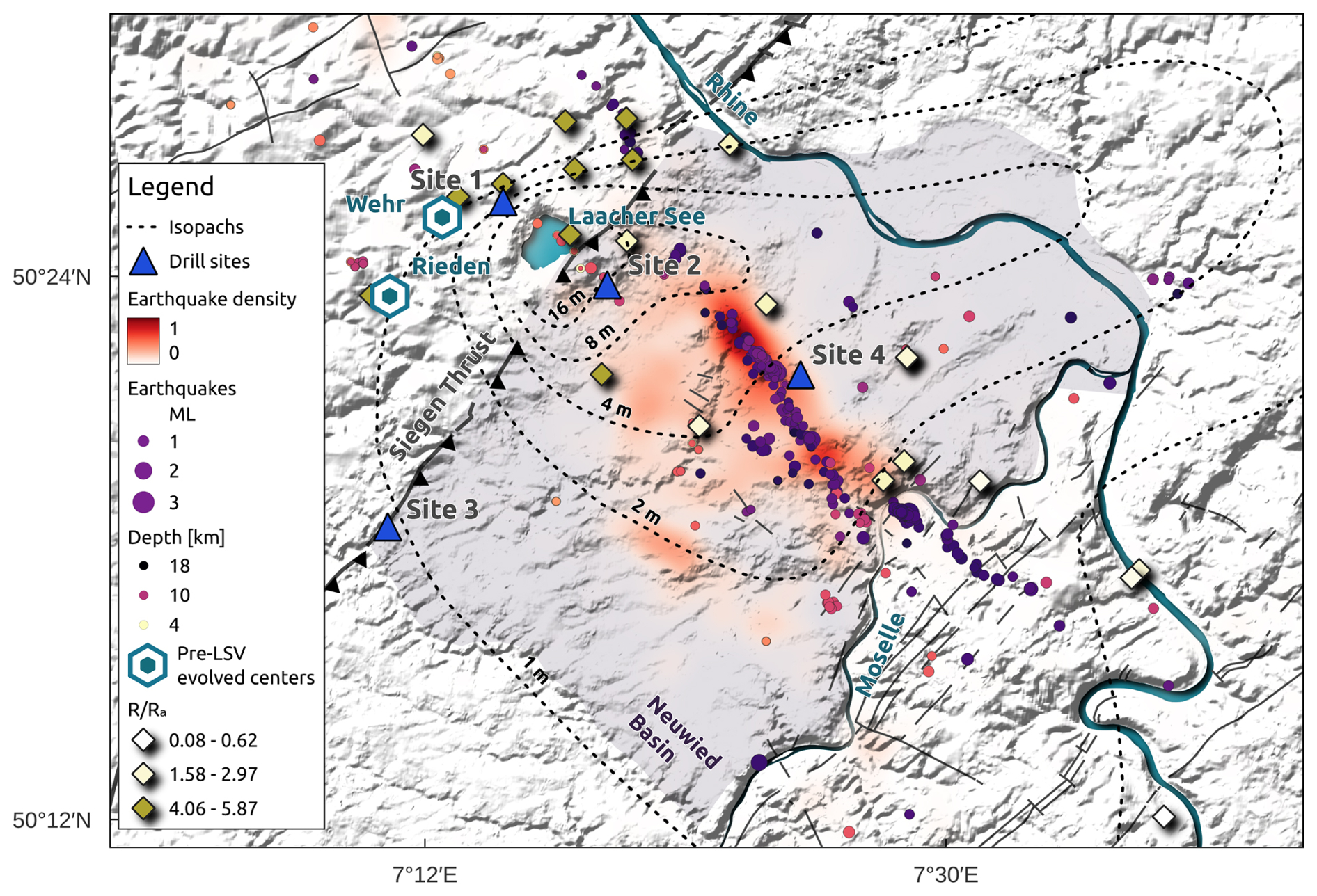
Figure 7East Eifel explosive centres (Laacher See, Wehr, Rieden) are displayed together with major faults (including the Siegen Thrust), earthquakes, mofettes, and planned drill sites (see the legend). The grey-shaded area represents the Neuwied Basin, a region of subsidence starting in the Paleogene. Tephra isopaches of the 13 ka eruption of LSV are shown by dashed lines (Schmincke et al., 1999). The background earthquake density was calculated from 40 years of data from the Bensberg catalogue. Earthquakes displayed as purple circles were located using the Eifel Large-N experiment (Dahm et al., 2025). The values were taken from Bräuer et al. (2013).
The LSV location is ideal for probing a magmatic system at different depths through shallow (Phase 1, sites 1–4 in Fig. 7) and deep drilling (Phase 2). The objectives of shallow drilling to depths between 300 and 2000 m in Phase 1 include the sampling of CO2 and other gases prior to interaction with regional aquifers, quantifying geothermal gradients above the LSV reservoir, uncovering vent and dike structures, resolving the geological history of basin subsidence and uplift in relation to Quaternary volcanic phases, and recovering evidence for potentially CO2-related precursor activity of LSV. Fluid sampling during this drilling phase will provide information on gas compositions, CO2 sources, and rare-element contents of the fluid. Complementing this is the sampling of rocks exposed to protracted CO2 fluxes. Shallow wells could also be used to improve monitoring and structural imaging with geophysical methods. This information is necessary to determine the optimal location for scientific deep drilling in a second phase. Borehole thermometry, tiltmeters, geophones, optical fibres, and pressure sensors could measure fluid fluxes, fluid geochemistry, pressure pulses, temperature, deformation, and earthquake events related to magmatic and hydrothermal processes. Using active and passive seismological and geophysical methods, as well as integrating data from the Eifel Large-N passive seismological experiment (Dahm et al., 2025), which was carried out in 2022–2023, will help calibrate and improve imaging approaches for the uppermost 8 km. Shallow drilling to down to 2 km depth will also amend the critical absence of reliable heat flow data for LSV and vicinity. Altogether, results of the shallow drilling will inform the selection of the optimal location for the deep drilling in Phase 2.
As an aspirational goal for future Phase-2 ICDP drilling, workshop participants proposed targeting trapped fluids and rocks proximal to the upper crustal magma reservoir beyond the depths drilled during Phase 1. At 4–6 km depth, a potentially active silicate–carbonatite intrusive complex is anticipated to exist underneath the Laacher See diatreme, as indicated by plutonic ejecta in the Upper Laacher See tephra deposits (e.g. Schmitt et al., 2010). This complex has been forming since at least 63 ka (Fig. 3) and was frequently rejuvenated by magma recharge (Schmitt et al., 2022). Magma injections are likely to have continued since the 13 ka eruption of LSV. The magmatic reservoir extends down to 10 km depth as resolved by seismic high-resolution tomography (Zhang et al., 2026). Because of its longevity and size, elevated temperatures and degassing likely persist at the depth from which the LSV magma vented, and associated magmatic–hydrothermal fluids may cause ongoing fenitisation and mineralisation in the magmatic carapace and its caprock, similarly to processes that have preconditioned world-class REE deposits in the geological past. While plutonic ejecta and xenoliths present as accidental clasts in LSV pyroclastic deposits have provided valuable insights, they lack the spatial and petrological context that only drilled samples can provide. The volumes and distribution of carbonatite intrusions in the LSV subsurface and their role in sequestering mantle-derived CO2 remain unknown. Even one-dimensional sampling of such a system through one deep (3000–4000 m) hole would be a major breakthrough and globally unique. This would also present an opportunity to assess the current physical and chemical conditions within the residual and possibly rejuvenating magma reservoir and its hydrothermal aureole, with implications for volcanic hazards and harnessing magmatic geothermal energy. In situ sampling of rocks and fluids within an active hydrothermal system would also provide essential input to reconstruct the processes that formed fossil silicate–carbonatite complexes and their mineralisation (Fig. 4). Because of the costs and technical challenges of coring at such depths, Phase 2 will require careful preparation, for which results from Phase-1 drilling will be informative. We therefore concentrate in the following on the immediate plans for drilling in Phase 1.
4.2 Specific research opportunities for Phase-1 drilling and drill site selection
4.2.1 Translithospheric fluid–magma transport and storage
It remains a fundamental challenge to bridge near-surface observations with inferred processes at the different depth levels where magma originates, ascends, and ponds. A pivotal question is therefore as follows: where does a free CO2 phase emerge and how is it modified upon ascent? The LSV magmas were volatile-rich (including CO2 and SO2), and the region around the village of Glees has been a focal point of extremely high CO2 surface fluxes to the present day. In the vicinity of Glees, CO2 is also extracted from multiple drill wells in industrial operations. A quarry near Glees exposes diatreme structures that hint at cold CO2 eruptions, suggesting cataclysmic CO2 outbursts in the past (e.g. Park et al., 2021; Schmincke et al., 2025). Ongoing quarrying threatens the preservation of these structures, and thorough documentation and broader exploration by drilling is urgent. Why this shallow hydrothermal system alternates between phases of steady background CO2 flux and short-term episodes of rapid uplift and deflation, possibly even culminating in explosive gas release, remains unanswered. Only drilling allows for the sampling of fluids close to their potential sources prior to gas–aquifer interaction and dilution to further clarify gas sources, pressure development, and transport processes.
Despite the size and young age of the LSV magma reservoir (> 70 km3 within a cylindrical conduit between 2 and 10 km depth), no significant heat flow anomaly has been identified, although reliable estimates are rare. On the other hand, a significant large-scale magnetic anomaly is lacking beneath the Wehr and LSV, in contrast to Kelberg in the Hocheifel, which may indicate that the bulk of residual magma in the upper crust is still above Curie temperatures. This apparent paradox may be resolved by drilling, where shallow drilling into the subsurface around LSV would provide the first reliable heat flow measurements for this site at depths of > 100 m. Drilling would also provide critical input to constrain the thermal and mechanical state of the shallow crust and the residual intrusive complex, as well as the possible role of overpressured CO2-rich groundwater reservoirs.
In addition to heat flow estimates, sampling of deep fluids may trace the degassing of magma at different depths underneath LSV. As CO2 reservoirs exist in shallow, sealed aquifers under high pressure, they can be explored for both energy and heat production and studied as a potential natural laboratory for CO2 sequestration due to the high CO2-to-rock ratios and the longevity of the system. Minerals precipitated from this high-CO2 hydrothermal system can be sampled from the drill cores to provide important information on the conditions and processes of CO2 reacting with crustal rocks to form carbonates and to quantify CO2 sequestration. Results from this aspect of the work will provide more quantitative constraints for CO2 emissions from distributed volcanic fields and lay the groundwork to conceptualise anthropogenic CO2 sequestration in continental settings. Hydrothermal systems above shallow intrusive complexes also control the transport and enrichment of critical metals, which is another opportunity to be approached by drilling and related research, although this will occur in Phase 2.
4.2.2 CO2-related volcanic hazards
The Cenozoic Eifel volcanic province is the product of more than 800 volcanic eruptions within a region of 3200 km2 over the last 45 Myr. Quaternary volcanism with more than 350 volcanoes is mostly concentrated in the EEVF and WEVF, with the youngest eruptions at the Ulmener Maar (maar diatreme, 11 ka; Zolitschka et al., 2000; Preusser et al., 2011) and with LSV showing explosive events. Recent studies have resolved the lifetime and evolution of the evolved, zoned reservoir beneath LSV over the last ca. 63 kyr (Schmitt et al., 2010, 2022), with U-series olivine model ages for the onset of basanite differentiation dating back to ca. 100 ka (Bourdon et al., 1994). While the reservoir remained hot and at least partially viable for eruption over a protracted period (Rout and Wörner, 2018), the VEI 6 eruption of LSV occurred very briefly (days to several months) after crystal entrainment in the recharge magma and mingling of CO2-rich magma in the phonolite reservoir (Rout and Wörner, 2020; Sundermeyer et al., 2020) that may have triggered the eruption. This spontaneous response poses a major challenge to assess and quantify the volcanic hazard associated with phonolitic magmatic systems within the EEVF and elsewhere. Drilling in Phase 1 will help to better resolve the active parts of the LSV reservoir, e.g. by calibrating geophysical imaging methods through a comparison between existing data from the Eifel Large-N experiment and borehole lithology.
Explosive diatreme forming or maar-type eruptions occurred frequently in the WEVF and EEVF. Maars in the WEVF may result from explosive eruptions involving CO2-bearing melts (e.g. Rausch et al., 2015; Schmincke et al., 2025), in contrast to commonly invoked phreatomagmatic processes leading to the formation of maars (e.g. Kurzlaukis and Lorenz, 2016). The region around Glees (see site 1 in Fig. 7) is affected by ongoing transient deformation and possible pressurisation of the deep aquifers by CO2. We hypothesise that these processes are related to historic and geological evidence for CO2 outbursts, causing gas diatreme formation and limnic eruptions. For these events, the associated hazards are also generally poorly understood. The Glees site stands out by offering opportunities to study a CO2-rich hydrothermal system and possible geologic evidence for violent gas outbursts in the past. Another promising site (Krufter Waldsee) is a maar structure in proximity to LSV (site 2 in Fig. 7). Shallow lake sediments in this maar potentially preserve evidence for LSV precursor events, whereas its deeper parts can provide access to diatreme structures.
Explosive eruption dynamics involve a complex interplay between vent geometry and multi-phase flow. The Laacher See eruption deposits are well studied in terms of eruptive style and relative timing, but the corresponding vent structure remains obscured. Through high-resolution geophysical imaging in combination with borehole sensors (or sources), the shallow structures (surface to 1–2 km depth) can be mapped to better constrain vent geometries of the LSV system. Moreover, there is potential to directly sample lateral dikes of the central LSV vent system. While these topics are a key focus for Phase 2, potentially transforming insights into the mechanisms of phase separation and fluid release, especially during eruption, can be gained already during Phase 1 by studying hydrothermal fluids, damage zones (permeable structures), and potentially penetrated shallow intrusions (sills and dikes). Furthermore, quantitative constraints about the role of volatiles and fragmentation in CO2-rich primitive melts will improve the understanding of potential precursors to maar eruptions and their related hazards.
CO2-rich fluids are also increasingly being recognised as exerting a major control on phase equilibria in silicate melts. Upsetting fluid–crystal–melt equilibria due to the influx of CO2 from degassing mafic melts at depth can destabilise magma stored in near-surface reservoirs and possibly trigger eruptions (e.g. Caricchi et al., 2018; Pappalardo et al., 2022). The hazards related to carbonatitic eruptions remain elusive due to their sparse yet potentially devastating occurrences. Laacher See is one of the youngest volcanoes worldwide that erupted carbonatitic rocks from a shallow intrusive complex. Carbonatite–silicate magma evolution via differentiation, unmixing, and melt segregation can be studied at high fidelity at LSV (e.g. Berndt and Klemme, 2022; Anenburg and Guzmics, 2023, and reply). This will undoubtedly provide unique insights into the evolution of an active phonolite–carbonatite magma system with a shallow aureole affected by fluid-driven metasomatism.
Supporting the research questions above, shallow wells from Phase 1 will be used for enhanced multiparameter monitoring, including the detection of micro-earthquakes, DLF events, and pressure and temperature transients in the shallow-aquifer system. This will improve the ability to identify and interpret unrest at depth early and to detect weak precursor signals for magma ascent.
4.2.3 Current drilling-related activities and site selection in the EEVF
The workshops and the ICDP initiative have already initiated research relevant for selecting drill sites that will allow us to address the key research questions outlined above. In a joint effort involving a consortium of universities, research institutes, and state geological surveys, a large passive seismological experiment was conducted between 2022 and 2023, involving over 500 stations that recorded data for 1 year or longer (e.g. Dahm et al., 2025). The large number of densely deployed stations and local earthquakes in the EEVF area enabled the creation of a high-resolution 3D image of velocity anomalies (Zhang et al., 2026). This resolved the location, shape, and depth of the LSV upper-crustal reservoir that produced the VEI 6 eruption 13 kyr ago. Ongoing analysis of the large dataset indicates strong upwelling of the Moho, where DLF earthquakes occur in the lower crust and where magmatic sill layers exist beneath the Neuwied Basin and Laacher See at a depth of 25 km, just beneath the velocity anomaly of the LSV reservoir. Likewise, 3D gravity inversion and magnetotelluric surveys are ongoing. Initiated by the Large-N and ICDP projects, multiparameter surface stations have been deployed close to Laacher See, including approximately 22 real-time GNSS stations; a superconducting gravimeter; and more than 8 continuous fluid-monitoring sites, including spectrochemical analysis of fluids.
A first well (site 1, Fig. 7) is planned in a CO2 mofette location close to Glees, about 1.6 km NW of the Laacher See as part of the ERC Synergy Project “Archean Park” (Jens Kallmeyer, personal communication, December 2025). Drilling with a target depth of 300 m is planned for winter 2025 to spring 2026. In close vicinity (∼ 100 m), there is an existing 800 m well that is used for CO2 production (not cored). The plot on which the drilling will be carried out is owned by the company SOL, and they have already granted permission to drill. Drilling will be carried out in close collaboration with the ICDP Operation Support Group and according to ICDP standards (use of mDIS, sample labelling, subsequent geophysical monitoring, etc.). In addition, there are existing exploration wells in the Wehr basin, which host the eponymous volcanic complex that is the direct precursor to LSV. These are currently being re-analysed for geochemistry and petrology (Franz May, BGR, personal communication, November 2025). This provides leverage for the proposed ICDP drilling, for which three additional drilling sites are planned. Drilling at site 1 has a high prospect of recovering samples to study the interaction between rocks and CO2 fluids, but, due to widespread diffuse degassing in the EEVF, this may also be the case for the other sites.
A second well (site 2) is proposed for a location near Krufter Waldsee, ∼ 3 km southeast of the centre of Laacher See. The site is located in a zone of abandoned pumice quarries, which offers advantages for permitting and access. During quarrying operations and in a water well drilled in 2022, sediments from a paleolake were encountered that underlie LSV pyroclastic deposits. Based on a prominent morphological depression, this paleolake may have filled a small (∼ 1 km diameter) maar volcano postdating emplacement of the ca. 200 ka basanitic scoria cones of Krufter Ofen, Nickenicher Hummerich, and Koppiger Stein. The presence of maar lakes similar to the Krufter paleolake in the region of the future Laacher See crater is indicated by lake-deposited diatomites entrained in LSV pyroclastic flow deposits (Braun and Meyer, 1996). Phreatomagmatic activity prior to the Laacher See eruption is also evident from undated pyroclastic deposits underlying Laacher See tephra in the Eppelsberg quarry ∼ 500 m to the east of site 2. Drilling into a maar structure near LSV will provide unprecedented data on potential LSV precursors with tight stratigraphic constraints from laminated maar sediments and regional tephra correlations. In addition to sampling pre-LSV maar deposits with shallow (∼ 300 m) drill cores, site 2 also offers ideal conditions for enhanced geophysical monitoring (e.g. heat flow) due to its proximity to Laacher See and due to it being located directly above the zone of DLF earthquakes. Deepening the site-2 well into the bedrock made of slates and schist to ∼ 2000 m is thus proposed without coring if the budget allows. The site-2 well is also considered to be a promising pilot hole for a second-phase deep drill hole.
The objective of drilling site 3 is to test the hypothesis that near-surface transients in fluid composition and temperature, surface deformation, or gravity correlate with fluid- or melt-induced DLF earthquakes. Site 3 was selected to improve the detection and monitoring of changes in reflector characteristics at a depth of z = 12 km, where the strength and nature of the reflections suggest that they originate from a sill-like reservoir with high fluid content, possibly CO2 or melt. Strong SzS reflected waves from earthquakes in the Ochtendung fault zone are recorded at seismic stations ∼ 10 km from the epicentre. The relative timing and localisation of the reflected phases indicate wave generation by a reflector with dimensions of ∼ 3 km at ∼ 12 km depth, just beneath the bottom of the LSV velocity anomaly interpreted to be an upper-crustal magma reservoir. Monitoring will be achieved by equipping the well with a modern 3D seismic array (i.e. borehole chain, broadband sensor, and fibre-optic cable behind the casing), as well as a small aperture surface array, which will allow for dedicated seismic beam-forming analysis. Drilling will also provide samples across the Siegen Thrust, a major regional structure terminating in a mid-crustal décollement formed during the Variscan collision (Oncken et al., 1999). Although presently tectonically inactive, traces of repeating DLF earthquakes indicate that it may control fluid ascent. A low-seismic-velocity body dipping subparallel to the Siegen Thrust links the lower-crustal magma reservoir to LSV, where mantle-derived CO2 is currently outgassing. Drilling allows access to rocks across the fault zone and for us to determine their seismic properties, which are otherwise buried by Paleogene–Quaternary deposits.
Drilling at site 4 is proposed to investigate volcano–tectonic processes that are associated with magma venting during the 13 ka eruption of LSV. Small-scale horst and graben structures have been identified in proximal tephra deposits (e.g. those visible at the Wingertsbergwand; see Fig. 6), indicating subsidence within the first 12 h of the eruption. New findings on the size, depth, and shape of the LSV reservoir (Zhang et al., 2026) suggest that co-eruptive subsidence caused by the eruptive decrease in reservoir overpressure extended further southeast of LSV than presently known. Drilling can provide direct constraints on the depth to the pre-Laacher-See eruption surface to improve models on the extent and location of graben border faults. These faults also control where CO2 ascends from the LSV reservoir today, providing a direct window through which to monitor the state of and changes in magmatic fluids in the LSV reservoir.
The Eifel region in Germany hosts hundreds of distributed volcanoes of Quaternary age in an intracontinental setting, and it is internationally renowned as the type locality of maar volcanism. Laacher See in the eastern part of the region stands out as a sizable, dormant volcano. In close proximity to LSV, active deformation and seismic unrest as represented by DLF earthquakes have been recorded, which only became possible through recent methodological refinements. Collectively, these observations indicate fluid or melt transport from the upper mantle to shallow crustal levels, where the LSV magma reservoir had developed over several tens of thousands of years prior to its cataclysmic venting ca. 13 kyr ago. Diffuse CO2 degassing is ongoing at and around LSV. CO2 is also a significant magmatic component in the Eifel, as evidenced by cogenetic carbonatite clasts being ejected during the Laacher See cataclysm. Recent advances in detecting ongoing translithospheric movement of fluids or melts underneath LSV and petrological insights into the remarkable longevity of the pre-13 ka magma reservoir notwithstanding, it remains unresolved as to why the shallow hydrothermal system above the residual magma system is seemingly cold, although it is highly dynamic based on ongoing CO2 degassing, seismic activity, and exceptionally high rates of uplift on spatial scales of hundreds of kilometres.
Table 2Workshop outcomes in a synoptic framework of research priorities and objectives for scientific drilling around LSV.
Drilling in the Laacher See region offers tremendous potential to enhance the knowledge on distributed volcanic fields, which are characterised by irregular eruptive recurrence over protracted durations of activity. It can also address the specific hazards resulting from high CO2 fluxes from the mantle to the surface. Laacher See is also an ideal test bed to evaluate the physical and chemical properties of a shallow (∼ 4 km depth at its top) intrusive silicate–carbonatite complex formed by volatile-rich magmas and an associated hydrothermal system, both accessible to deep drilling. Moreover, silicate–carbonatite magma systems are globally recognised as major hosts for critical metal deposits, which, in the case of Laacher See, could be investigations in the making. Only drilling can provide definitive answers to the research questions summarised in Table 2. The suitability for scientific drilling in the Eifel is underscored by this region boasting an extensive record of past research; easy access; and excellent infrastructure, including Earth Science departments in nearby universities, that uniquely permits the implementation of cutting-edge scientific methods to study this type of distributed volcanism.
Workshop participants represented a broad and diverse international community. Fuelled by participant communication, research goals were collaboratively developed and refined. These research goals are directly in line with ICDP priorities, and drilling offers unique opportunities to achieve them. Seed funding by ICDP for a workshop held under the title “Follow the CO2 – Drilling into an actively degassing intraplate volcano underlain by a silicate-carbonatite intrusion” has enabled the sharpening of scientific questions that are of relevance to distributed volcanic fields worldwide. This also led to us homing in on a two-phase drilling strategy, with four shallow (∼ 300–2000 m) drill wells proposed for Phase 1 and one deep well for coring at ∼ 3000–4000 m in Phase 2. This offers the advantage of refined geophysical exploration prior to deciding on a site for expensive deep drilling. High-priority research activities around the four proposed drill sites for Phase 1 include (1) integrating geophysics, gas, and rock geochemistry; structural geology; and stratigraphy to resolve transcrustal magma transport, storage, and venting in distributed volcanic fields; (2) identifying the unique hazards of CO2 in explosive gas surges as a component in maar-type eruptions and as an eruption trigger for shallow differentiated magma accumulations; (3) direct sampling of CO2 and other fluids above a long-lived phonolite–carbonatite magma system to assess the fluxes of CO2 degassing and sequestration in carbonatite and secondary carbonates; (4) assessing syneruptive volcano–tectonic processes during venting of the Laacher See magma reservoir as related to recent re-assessments of reservoir geometry; (5) improving constraints on the current physical and chemical conditions in the residual LSV magma reservoir, including reliable heat flow measurements; and (6) correlating surface observables (e.g. gas geochemistry, gravity, uplift) with seismic records of transcrustal DLF earthquakes to identify ongoing fluid or melt transport. Lastly, the workshop also allowed for a productive review of prior and current research activities in the Eifel. Ongoing scientific and industrial drilling for CO2 further leverages the request to support future scientific drilling in the Eifel, which is planned for submission to ICDP in January 2026.
Research data are completely presented in Table 1. This table reproduces the report that was obtained from the laboratory.
TD and AKS organised the workshops, with all of the authors contributing to the coordination and programme. TD, AKS, and NK wrote the draft of the paper, and SdS, TF, AH and JT reviewed and improved the text. TD, AS, and AKS provided the figures. AS contributed the interpretation of radiocarbon ages.
The contact author has declared that none of the authors has any competing interests.
Publisher's note: Copernicus Publications remains neutral with regard to jurisdictional claims made in the text, published maps, institutional affiliations, or any other geographical representation in this paper. The authors bear the ultimate responsibility for providing appropriate place names. Views expressed in the text are those of the authors and do not necessarily reflect the views of the publisher.
We would like to express our special thanks to the German Physical Society for their support in hosting the workshop at their premises in Bad Honnef. We would also like to thank Susanne Köster, GFZ, for her professional organisation and support. ICDP provided financial support for the workshop. We would also like to thank all of the participants who contributed to the cost of their travel expenses. Susanne Lindauer and Ronny Friedrich (Curt-Engelhorn-Zentrum Archäometrie, Mannheim) are thanked for carrying out the radiocarbon analyses. Klaus Rick GmbH & Co. KG kindly provided access to their quarry during the workshop. The journal reviewers Jonas Preine and John Shervais provided constructive and insightful comments. We also thank Will Sager for the editorial handling.
This research has been supported by the Deutsche Forschungsgemeinschaft (DFG, project no. 450662246).
This paper was edited by Will Sager and reviewed by Jonas Preine and John Shervais.
Alohali, A., Bertin, D., de Silva, S., Cronin, S., Duncan, R., Qaysi, S., and Moufti, M.: Spatio-temporal forecasting of future volcanism at Harrat Khaybar, Saudi Arabia, Journal of Applied Volcanology, https://doi.org/10.1186/s13617-022-00124-z, 2022. a, b
Anenburg, M. and Guzmics, T.: Silica is unlikely to be soluble in upper crustal carbonatite melts, Nature Communications, 14, 942, https://doi.org/10.1038/s41467-023-35840-6, 2023. a, b
Berndt, J. and Klemme, S.: Origin of carbonatites–liquid immiscibility caught in the act, Nature Communications, 13, 1–8, 2022. a, b, c
Berndt, J. and Klemme, S.: Reply to: Silica is unlikely to be soluble in upper crustal carbonatite melts, Nature Communications, 14, 943, https://doi.org/10.1038/s41467-023-35841-5, 2023. a
Berndt, J., Holtz, F., and Koepke, J.: Experimental constraints on storage conditions in the chemically zoned phonolitic magma chamber of the Laacher See Volcano, Contrib. Mineral. Petrol., 469–486, https://doi.org/10.1007/PL00007674, 2001. a
Bourdon, B., Zindler, A., and Wörner, G.: Evolution of the Laacher See magma chamber:Evidence from SIMS and TIMS measurements of U–Th disequilibria in minerals and glasses, Earth and Planetary Science Letters, 126, https://doi.org/10.1016/0012-821X(94)90243-7, 1994. a, b
Bräuer, K., Kämpf, H., Niedermann, S., and Strauch, G.: Indications for the existence of different magmatic reservoirs beneath the Eifel area (Germany): A multi-isotope (C, N, He, Ne, Ar) approach, Chemical Geology, 356, 193–208, https://doi.org/10.1016/j.chemgeo.2013.08.013, 2013. a, b, c
Braun, A. and Meyer, W.: Ein Kieselgur-Einschluss im allerödzeitzlichen Aschestrom des Brohltals (Laacher-See-Gebiet) und seine regionalgeologische Bedeutung, Decheniana, 149, 1996. a
Caricchi, L., Sheldrake, T., and Blundly, J.: Modulation of magmatic processes by CO2 flushing, Earth Plan. Sci. Lett., 491, 160–171, 2018. a, b
Crosetto, M., Solari, L., Mróz, M., Balasis-Levinsen, J., Casagli, N., Frei, M., Oyen, A., Moldestad, D., Bateson, L., Guerrieri, L., Comerci, V., and Andersen, H. S.: The evolution of wide-area DInSAR: From regional and national services to the European Ground Motion Service, Remote Sensing, 12, 2043, https://doi.org/10.3390/rs12122043, 2020. a
Crosetto, M., Solari, L., Balasis-Levinsen, J., Bateson, L., Casagli, N., Frei, M., Oyen, A., Moldstad, D., and Mróz, M.: Deformation monitoring at european scale: The Copernicus Ground Motion Service, The International Archives of the Photogrammetry, Remote Sensing and Spatial Information Sciences, XLIII-B3-2021, 141–146, 2021. a
Dahm, T., Stiller, M., Mechie, J., Heimann, S., Hensch, M., Woith, H., Schmidt, B., Gabriel, G., and Weber, M.: Seismological and Geophysical Signatures of the Deep Crustal Magma Systems of the Cenozoic Volcanic Fields Beneath the Eifel, Germany, Geochemistry, Geophysics, Geosystems, 21, e2020GC009062, https://doi.org/10.1029/2020GC009062, 2020. a, b, c, d, e, f, g
Dahm, T., Isken, M., Milkereit, C., Sens-Schönfelder, C., Eckel, F., Yuan, X., Reiss, M., Oth, A., Rümpker, G., De Siena, L., Büyükakpinar, P., Laumann, P., Zhang, H., Knapmeyer-Endrun, B., Mikulla, S., Bauz, R., Busch, S., Hensch, M., Schmidt, B., Petersen, G., and Cesca, S.: A seismological large-N multisensor experiment to study the magma transfer of intracontinental volcanic fields: The example of the Eifel, Germany, Seismica, 4, https://doi.org/10.26443/seismica.v4i2.1492, 2025. a, b, c, d
Denis, C. M., Demouchy, S., and Shaw, C. S.: Evidence of dehydration in peridotites from Eifel Volcanic Field and estimates of the rate of magma ascent, Journal of Volcanology and Geothermal Research, 258, 85–99, 2013. a
Eichelberger, J., Ingolfsson, H. P., Carrigan, C., Lavallee, Y., Tester, J., and Markusson, S. H.: Krafla magma testbed: Understanding and using the magma-hydrothermal connection, Transactions Geothermal Resources Council, 42, 2396–2405, 2018. a
Elders, W., Friðleifsson2, G., Zierenberg, R., Pope, E., Mortensen, A., Guðmundsson, A., Lowenstern, J., Marks, N., Owens, L., Bird, D., Reed, M., Olsen, N., and Schiffman, P.: Origin of a rhyolite that intruded a geothermal well while drilling at the Krafl a volcano, Iceland, Geology, 39, 231–234, https://doi.org/10.1130/G31393.1, 2011. a
Fekiacova, Z., Mertz, D. F., and Renne, P. R.: Geodynamic setting of the Tertiary Hocheifel volcanism (Germany). Part I: 40Ar/39Ar geochronology, in: Mantle plumes: A multidisciplinary approach, Berlin, Heidelberg: Springer Berlin Heidelberg, 185–206, https://doi.org/10.1007/978-3-540-68046-8_6, 2007. a
Fischer, T. and Aiuppa, A.: AGU Centennial Grand Challenge: Volcanoes and Deep Carbon Global CO2 emissions from subaerial volcanism: recent progress and future challenges, G-cubed, 21, e2019GC008690, https://doi.org/10.1029/2019GC008690, 2020. a
Förster, M. W., Zemlitskaya, A., Otter, L. M., Buhre, S., and Sirocko, F.: Late Pleistocene Eifel eruptions: insights from clinopyroxene and glass geochemistry of tephra layers from Eifel Laminated Sediment Archive sediment cores, Journal of Quaternary Science, 35, 186–198, https://doi.org/10.1002/jqs.3134, 2020. a
Goepel, A., Lonschinski, M., Viereck, L., Büchel, G., and Kukowski, N.: Volcano-tectonic structures and CO2-degassing patterns in the Laacher See basin, Germany, International Journal of Earth Sciences, 104, 1483–1495, https://doi.org/10.1007/s00531-014-1133-3, 2015. a
Hensch, M., Dahm, T., Ritter, J., Heimann, S., Schmidt, B., Stange, S., and Lehmann, K.: Deep low-frequency earthquakes reveal ongoing magmatic recharge beneath Laacher See Volcano (Eifel, Germany), Geophysical Journal International, 216, 2025–2036, https://doi.org/10.1093/gji/ggy532, 2019. a, b, c, d
Hopkins, J. L., Smid, E. R., Eccles, J. D., Hayes, J. L.and Hayward, B. W., McGee, L. E., van Wijk, K., Wilson, T. M., Cronin, S., Leonard, G. S., and Lindsay, J. M.: Auckland Volcanic Field magmatism, volcanism, and hazard: a review, New Zealand Journal of Geology and Geophysics, 64, 213–234, https://doi.org/10.1080/00288306.2020.1736102, 2021. a
Kreemer, C., Blewitt, G., and Davis, P. M.: Geodetic evidence for a buoyant mantle plume beneath the Eifel volcanic area, NW Europe, Geophysical Journal International, 222, 1316–1332, https://doi.org/10.1093/gji/ggaa227, 2020. a, b
Kurzlaukis, S. and Lorenz, V.: Differences and similarities between emplacement models of kimberlite and basaltic maar-diatreme volcanoes, in: Monogenetic Volcanism, edited by: Nemeth, K., Carrasco-Nunez, G., Aranda-Gomez, J. J., and Smith, I. E. M., vol. 446, Geological Society, London, Special Publications, https://doi.org/10.1144/SP446.5, 2016. a
Liebsch, M.: Die Genese der Laacher See-Karbonatite, PhD thesis, Georg-August Universität, Göttingen, 1996. a, b, c, d
Martel, C., Champallier, R., Prouteau, G., Pichavant, M., Arbaret, L., Balcone-Boissard, H., Boudon, G., Boivin, P., Bourdier, J., and Scaillet, B.: Trachyte phase relations and implication for magma storage conditions in the Chaîne des Puys (French Massif Central), Journal of Petrology, 54, 1071–1107, https://doi.org/10.1093/petrology/egt006, 2013. a
Oncken, O., Winterfeld, C., and Dittmar, U.: Accretion of a rifted passive margin: The Late Paleozoic Rhenohercynian fold and thrust belt (Middle European Variscides), Tectonics, 18, 75–91, 1999. a
Pappalardo, L., Buono, G., Fanara, S., Yi, J., Shan, X., Guo, Z., and Ventura, G.: The role of CO2 flushing in triggering the “Millennium” eruption and recent unrests at Changbaishan volcano (China/North Korea), International Geology Review, 1–14, https://doi.org/10.1080/00206814.2022.2065544, 2022. a, b
Park, C., Schmincke, H.-U., and Sumita, M.: The pre-LST Glees Diatrem, an enigmatic and unique structure, caused by powerful CO2-streaming? (Young diatremes at Glees), Physics of Volcanoes 2021 Workshop POV-7, 9–10 March 2021, 2021. a, b, c, d, e, f, g, h, i
Park, C., Schmincke, H.-U., and Sumita, M.: Multiple diatreme eruptions at Glees – precursors to the paroxysmal eruption of Laacher See Volcano?, Physics of Volcanoes Workshop POV-9, 1–3 March 2023, Hannover, Germany, 2023. a, b, c, d, e, f
Pirajno, F. and Yu, H. C.: The carbonatite story once more and associated REE mineral systems, Gondwana Research, 107, https://doi.org/10.1016/j.gr.2022.03.006, 2022. a, b, c
Preusser, F., Rufer, D., and Schreurs, G.: Direct dating of Quaternary phreatic maar eruptions by luminescence methods, Geology, 39, https://doi.org/10.1130/G32345.1, 2011. a, b
Rausch, J., Grobety, B., and Vonlanthen, P.: Eifel maars: Quantitative shape characterization of juvenile ash particles (Eifel Volcanic Field, Germany), J. Volc. Geotherm. Res., 291, 86–100, 2015. a
Reinig, F., Wacker, L., Jöris, O., Oppenheimer, C., Guidobaldi, G., Nievergelt, D., Adolphi, F., Cherubini, P., Engels, S., Esper, J., Land, A., Lane, C., Pfanz, H., Remmele, S., Sigl, M., Sookdeo, A., and Büntgen, U.: Precise date for the Laacher See eruption synchronizes the Younger Dryas, Nature, 595, 66–69, https://doi.org/10.1144/jgs2022-064, 2021. a, b
Ritter, J. R. R.: The Seismic Signature of the Eifel Plume, in: Mantle Plumes – A Multidisciplinary Approach, edited by: Ritter, J. and Christensen, U. R., Springer, Heidelberg, 379–404, https://doi.org/10.1007/978-3-540-68046-8_12, 2007. a
Rout, S. and Wörner, G.: Zoning and exsolution in alkali feldspars from the LSV: constraints on temperature history prior to eruption, Contr. Mineral. Petrol., https://doi.org/10.1007/s00410-018-1522-x, 2018. a, b
Rout, S. and Wörner, G.: Constraints on the pre-eruptive magmatic history of the Quaternary Laacher See volcano (Germany), Contributions to Mineralogy and Petrology, 175, 1432–0967, https://doi.org/10.1007/s00410-020-01710-3, 2020. a, b
Sachs, P. M. and Hansteen, T. H.: Pleistocene underplating and metasomatism of the lower continental crust: a xenolith study, Journal of Petrology, 41, https://doi.org/10.1093/petrology/41.3.331, 2000. a
Schmincke, H.: The Quaternary Volcanic Fields of the East and West Eifel (Germany), in: Mantle Plumes – A Multidisciplinary Approach, edited by: Ritter, J. and Christensen, U., Springer, Heidelberg, 241–322, https://doi.org/10.1007/978-3-540-68046-8_12, 2007. a, b, c
Schmincke, H., Sumita, M., Chakraborty, S., and Hansteen, T.: Origin of maar clusters at the type locality Eifel (Germany): H2O or CO2?, Bull. Volcanol., 87, https://doi.org/10.1007/s00445-025-01800-9, 2025. a, b, c
Schmincke, H. U., Park, C., and Harms, E.: Evolution and environmental impacts of the eruption of Laacher See Volcano (Germany) 12 900 a BP, Quaternary International, 61, 61–72, 1999. a
Schmitt, A., Wetzel, F., Cooper, K., Zou, H., and Wörner, G.: Magmatic longevity of Laacher See Volcano (Eifel, Germany) indicated by intrusive carbonatites, J. Pet., 50, 1053–1085, https://doi.org/10.1093/petrology/egq011, 2010. a, b, c, d, e, f, g, h
Schmitt, A., Klitzke, M., Gerdes, A., and Schäfer, C.: Zircon Hafnium-Oxygen Isotope and Trace Element Petrochronology of Intraplate Volcanic Rocks from the Eifel (Germany), J. Petrol., 58, 1841–1870, 2017. a
Schmitt, A. K., Klügel, A., Böddeker, S., Gothieu, M., and Gerdes, A.: Depth and timing of magma evolution underneath the Emmelberg scoria cone in the West Eifel Volcanic Field; Depth and timing of magma evolution underneath the Emmelberg scoria cone in the West Eifel Volcanic Field, Neues Jahrbuch für Mineralogie-Abhandlungen, 198, 101–118, https://doi.org/10.1127/njma/2023/0358, 2023. a
Schmitt, F., Schmitt, A., Gerdes, A., and Harvey, J.: Magma accumulation underneath Laacher See volcano from detrital zircon in modern streams, Journal of the Geological Society, jgs2022-064, https://doi.org/10.1144/jgs2022-064, 2022. a, b
Seck, A. and Wedepohl, K.: Mantle Xenoliths in the Rhenish Massif and the Northern Hessian Depression, in: Plateau Uplift, edited by: Fuchs, K., von Gehlen, K., Mälzer, H., Murawski, H., and Semmel, A., Springer Verlag Heidelberg, 261–274, https://doi.org/10.1007/978-3-642-69219-2_38, 1983. a
Shaw, C. S.: Clinopyroxenite xenoliths record magma transport and crystallization in the middle and upper Crust: A case study from the Rockeskyllerkopf Volcanic Complex, West Eifel, Germany, Journal of Petrology, 65, egae035, https://doi.org/10.1093/petrology/egae035, 2024. a
Sturm, A., Schmitt, A. K., and Danisík, M.: Updating the Eifel record: Zircon double-dating of tephras from Wehr volcano (East Eifel, Germany) as marker horizons for the European Pleistocene loess stratigraphy, Quaternary Science Reviews, 338, 108810, https://doi.org/10.1016/j.quascirev.2024.108810, 2024. a, b
Sun, Z., Zhang, B., Wu, J., Zhu, Z., Sun, C., Guo, Z., and Liu, J.: Magmatic genesis, magmatic plumbing system, and geodynamic mechanism of Changbaishan volcanoes: New evidence from mineralogical, geochemical, and geothermobarometric data, Lithos, 514–515, 108167, https://doi.org/10.1016/j.lithos.2025.108167, 2025. a
Sundermeyer, C., Gätjen, J., Weimann, L., and Wörner, G.: Timescales from magma mixing to eruption in alkaline volcanism in the Eifel volcanic fields, western Germany, Contributions to Mineralogy and Petrology, 175, 1–23, https://doi.org/10.1007/s00410-020-01715-y, 2020. a, b, c, d
Taylor Jr., H. P., Frechen, J., and Degens, E. T.: Oxygen and carbon isotope studies of carbonatites from the Laacher See District, West Germany and the Alnö District, Sweden, Geochimica et Cosmochimica Acta, 31, 407–430, https://doi.org/10.1016/0016-7037(67)90051-8, 1965. a, b
Tomlinson, E., Smith, V., and Menzies, M.: Chemical zoning and open system processes in the Laacher See magmatic system, Contrib. Mineral. Petrol., 175, https://doi.org/10.1007/s00410-020-1657-4, 2020. a
Trieloff, M. and Altherr, R.: He-Ne-Ar Isotope Systematics of Eifel and Pannonean Basin Mantle Xenoliths Trace Deep Mantle Plume-Lithosphere Interaction Beneath European Continents, in: Mantle Plumes – A Multidisciplinary Approach, edited by: Ritter, J. and Christensen, U. R., Springer Verlag, Heidelberg, 339–368, https://doi.org/10.1007/978-3-540-68046-8_12, 2007. a
Warken, S. F., Schmitt, A. K., Scholz, D., Hertwig, A., Weber, M., Mertz-Kraus, R., Reinig, F., Esper, J., and Sigl, M.: Discovery of Laacher See eruption in speleothem record synchronizes Greenland and central European Late Glacial climate change, Science Advances, 11, eadt4057, https://doi.org/10.1126/sciadv.adt4057, 2025. a, b
Weidenfeller, M.: Geologie des Neuwieder Beckens und seiner Randgebiete (Exkursion C am 25. April 2019), Jahresberichte und Mitteilungen des Oberrheinischen Geologischen Vereins, 101, 61–94, https://doi.org/10.1127/jmogv/101/0003, 2019. a
Werner, C., Fischer, T., Appuia, A., Edmonds, M., Cardellini, C., and Carn, Chiodini, G. S.: Subaerial Volcanic Regions, Deep Carbon: Past to Present, ISBN 9781108477499, 2020. a
Wild, A. J., Bebbington, M. S., and Lindsay, J. M.: Short-Term Eruption Forecasting for Crisis Decision-Support in the Auckland Volcanic Field, New Zealand, Frontiers in Earth Science, 10, 893882, https://doi.org/10.3389/feart.2022.893882, 2022. a
Witt-Eickschen, G.: Thermal and geochemical evolution of the shallow subcontinental lithospheric mantle beneath the Eifel: Constraints from mantle xenoliths, a review, in: Mantle Plumes – A Multidisciplinary Approach, edited by: Ritter, J. and Christensen, U. R., Springer, 323–367, https://doi.org/10.1007/978-3-540-68046-8_12, 2007. a
Wörner, G. and Schmincke, H.-U.: Mineralogical and chemical zonation of the Laacher See tephra sequence (East Eifel, W. Germany), Journal of Petrology, 25, 805–835, https://doi.org/10.1093/petrology/25.4.805, 1984. a
Wörner, G., Schmincke, H., and Schreyer, W.: Crustal xenoliths from the Quaternary Wehr volcano (East Eifel), Neues Jahrb. Miner. Abh., 144, 29–55, 1982. a
Yaxley, G. M., Anenburg, M., Tappe, S., Decree, S., and Guzmics, T.: Carbonatites: classification, sources, evolution, and emplacement, Annual Review of Earth and Planetary Sciences, 50, 261–293, 2022. a, b, c, d
Zhang, H., Dahm, T., Haberland, C., Isken, M., Laumann, P., and Büyükakpınar, P.: The upper crustal structure of the Eifel volcanic region, southwest Germany from local earthquake tomography using Large-N seismic network data, J. Geophys. Res. Solid Earth, accepted, https://doi.org/10.1029/2025JB031338, 2026. a, b, c, d, e, f
Zolitschka, B., Brauer, A., Negendank, J. F., Stockhausen, H., and Lang, A.: Annually dated late Weichselian continental paleoclimate record from the Eifel, Germany, Geology, 28, https://doi.org/10.1130/0091-7613(2000)28<783:ADLWCP>2.0.CO;2, 2000. a, b
- Abstract
- Introduction
- Current knowledge of transcrustal fluid transfer in the East Eifel Volcanic Field
- Workshop deliberations and outcomes
- Proposal objectives
- Summary and outlook
- Data availability
- Author contributions
- Competing interests
- Disclaimer
- Acknowledgements
- Financial support
- Review statement
- References