the Creative Commons Attribution 4.0 License.
the Creative Commons Attribution 4.0 License.
 | 17 Mar 2026
Scientific deep drilling in the Chew Bahir basin: advantages and pitfalls of two overlapping sediment cores
Asfawossen Asrat
Christopher Bronk Ramsey
Erik T. Brown
Alan Deino
Asfaw Erbello
Markus L. Fischer
Daniel Gebregiorgis
Annett Junginger
Stefanie Kaboth-Bahr
Christine S. Lane
Stephan Opitz
Anders Noren
Helen M. Roberts
Ralph Tiedemann
Céline-Marie Vidal
Finn Viehberg
Ralf Vogelsang
Charlotte Zachow
Bahru Zinaye
Andrew S. Cohen
Henry F. Lamb
Frank Schaebitz
Martin H. Trauth
Chew Bahir, a lake that is dry for most of the year, located in a tectonic basin in the southern Ethiopian Rift, was the target of several scientific drilling expeditions between 2009 and 2014. The aim of these expeditions was to explore the basin and its lake sediments as an archive of past changes in the environmental conditions during the evolution of our species, Homo sapiens. In more than 25 publications, the scientific findings derived from the analysis of the sediments were presented and discussed in detail. In the present paper, we provide the background information on the project's origins, planning and implementation – that is, information that has not yet been presented in scientific papers, or only very briefly, but which could be important for those working on similar projects in the future. Herein, we particularly focus on the advantages and disadvantages of obtaining twin cores at a short distance, aiming at a continuous high-quality composite core, a strategy that had to be defended during the planning stage of the project due to the higher costs involved but which is considered to be the best practice for scientific drilling in modern sedimentary basins.
- Article
(8640 KB) - Full-text XML
- BibTeX
- EndNote


In a comparatively short time, Homo sapiens has evolved into one of the most successful biological species, spreading across the entire globe and adapting to almost all habitats thanks to technological innovation, flexibility facing a changing environment and social capacity (e.g. Stringer, 2016). Research into the causes of this success is as interesting as it is relevant, in view of the current threats to humanity by climate change, the overuse of natural resources and the spread of viruses through human activity.
The Hominin Sites and Paleolakes Drilling Project (HSPDP), initiated in November 2008, aimed to assemble continuous high-resolution paleoenvironmental records from lake-sediment archives in eastern Africa spanning critical intervals of human evolutionary history, tied to globally significant hominin sites (Cohen et al., 2016, 2022; Fig. 1a). Together with five other core locations in close proximity to important hominin fossil and archaeological sites, the Chew Bahir Drilling Project (CBDP) aimed to provide a continuous high-resolution multi-proxy paleoenvironmental record, allowing a direct comparison of environmental changes to the more fragmentary record of human and mammalian evolution, dispersal, extinction and cultural innovation (Foerster et al., 2012, 2022; Schaebitz et al., 2021). The project included multiple phases from pre-study to deep-drilling and consecutive analyses, and received funding from various sources, including the German Research Foundation (DFG) Collaborative Research Center (CRC) 806 funds to F. Schäbitz; several DFG grants to F. Schäbitz, M. H. Trauth, R. Tiedemann and V. Foerster within the DFG Priority Program SPP 1006 ICDP; the HSPDP grant from the International Continental Scientific Drilling Program (ICDP); US National Science Foundation (NSF) grants to A. Cohen from the Frontiers in Earth System Dynamics, Sedimentary Geology and Paleobiology, and Integrative Paleoanthropology programs; and a Natural Environment Research Council (NERC) grant to H. F. Lamb.
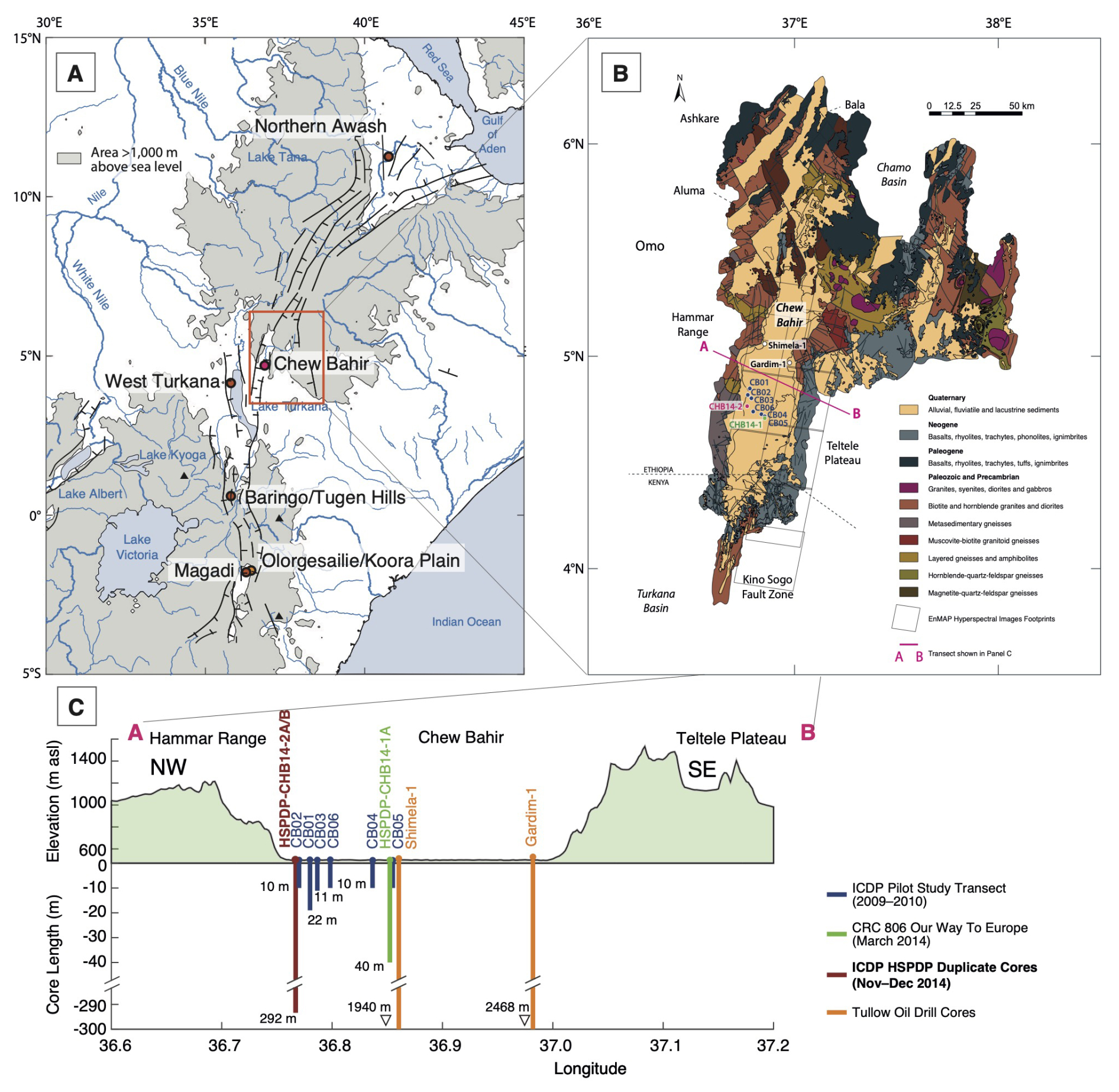
Figure 1Study area and localities of the lake cores. (a) Map of north-eastern Africa and adjacent areas showing the Ethiopian Highlands (in grey), the Ethiopian Rift (marked with thin black lines), the Chew Bahir basin (CHB; 4° N 36° E, ∼ 500 m above sea level) and the river Nile with its two tributaries. Dots indicate HSPDP-related projects from north to south along the EARS. Coastline and river polygons from the Global Self-consistent, Hierarchical, High-resolution Geography Database (GSHHG; Wessel and Smith, 1996). Topography from the 1 arcmin global relief model of the Earth's surface (ETOPO1; Amante and Eakins, 2009). (b) Geological map of the Chew Bahir basin showing the location of the short (<20 m) cores CB01–CB06 (2009–2010), the intermediate (∼ 40 m) core CHB14-1 (early 2014) and the long ICDP-HSPDP (∼ 300 m) cores CHB14-2 (late 2014). In addition, two petroleum exploration wells of Tullow Oil plc, Shimela–1 (∼ 1940 m) and Gardim–1 (∼ 2468 m), drilled in 2014 in the north-western and eastern flanks of the Chew Bahir basin, respectively, about 40 km north of the HSPDP-CHB14 location, helped to explore the deeper basin stratigraphy (together with seismic lines mentioned in Sect. 2.1 and shown in Fig. 3). Based on the Omo River Project Map (Davidson, 1983), Geology of the Sabarei Area (Key, 1988), Geology of the Yabello Area (Hailemeskel and Fekadu, 2004) and Geology of the Agere Maryam Area (Hassen et al., 1997). The grey squares show the areas hyperspectrally covered by the EnMAP satellite during the May and September 2023 flyovers. (c) Cross-section through the Chew Bahir basin with the location and length of the cores listed in Tables 1 and 2. The full stratigraphic column of CHB14-2 and corresponding detailed lithological descriptions of all core sections are freely available under Noren (2022).
Chew Bahir is a tectonic basin, separated from the Lower Omo basin to the west by the Hammar Range, which, along with the south-western Ethiopian Highlands, is the source of most of the sediments at the coring site (Foerster et al., 2012, 2018; Gebregiorgis et al., 2021; Fig. 1b). This range to the west and the highlands to the north and north-east consist of Late Proterozoic granitic and mafic gneisses, whereas the eastern part of the catchment is dominated by Miocene basaltic lava flows. Oligocene basalt flows with subordinate rhyolites, trachytes and tuffs, and ignimbrites cover the Precambrian basement units in the distal north-eastern, northern and north-western parts of the catchment (Moore and Davidson, 1978; Davidson, 1983). Being a closed basin lake, Chew Bahir forms a terminal sink for weathering products from its 32 400 km2 catchment. During the rainy seasons, the Chew Bahir mudflat is covered by a shallow column of water, mostly from the Weyto and Segen rivers entering the basin from the north. As a terminal sink for eroded material from the catchment since the Upper Miocene, the basin today contains 2–3 km, and possibly up to 5 km thick, fluvio-lacustrine sedimentary infill (Foerster et al., 2022).
Motorised access to the modern Chew Bahir basin is largely restricted to the western side, where the saline mudflat can be reached via lobes of alluvial fans off the main all-weather gravel road from Weyto to Turmi, which runs north–south along the eastern foot of the Hammar Range. The poorly graded off-road access tracks across the alluvial fans, which often are dismantled by flash floods during the rainy seasons and usually covered by thickets, are hardly drivable – only by 4WD vehicles. Driving becomes easier on the dry mudflat, particularly during the dry season. The western margins of the Chew Bahir mudflat are seasonally inhabited by Hammar pastoralists. The eastern margins of the Chew Bahir basin can only be accessed in its northern reaches along a west-bound gravel road from the Teltele Plateau, while the southern part where the mudflat is located is hardly accessible. The eastern extreme of the mudflat features some springs which serve as watering holes for the Borana pastoralists, who drive their cattle to the watering holes along narrow paths up and down steep cliffs.
In the framework of the HSPDP, we were able to collect two parallel cores from the Chew Bahir, ∼ 279 and ∼ 266 m long, ∼ 20 m apart from each other, during a 35 d coring campaign in November–December 2014 (Figs. 1 and 2, Tables 1 and 2). These twin cores were subsequently merged to a composite core, ∼ 293 m long, spanning the last ∼ 620 kyrs. Here we describe the progress of the project from its initiation, drilling and analyses, and the creation of a composite stratigraphy and age model. The deep drilling was preceded by several shallow coring campaigns between 2009 and 2014 (Figs. 1 and 2, Tables 1 and 2), the results of which we discuss here for the first time for all cores, to create a comprehensive high-resolution environmental record and infrastructural context for the Chew Bahir environmental archive. We also discuss the challenges and difficulties we encountered at all stages of the project and the lessons we learnt in resolving them.
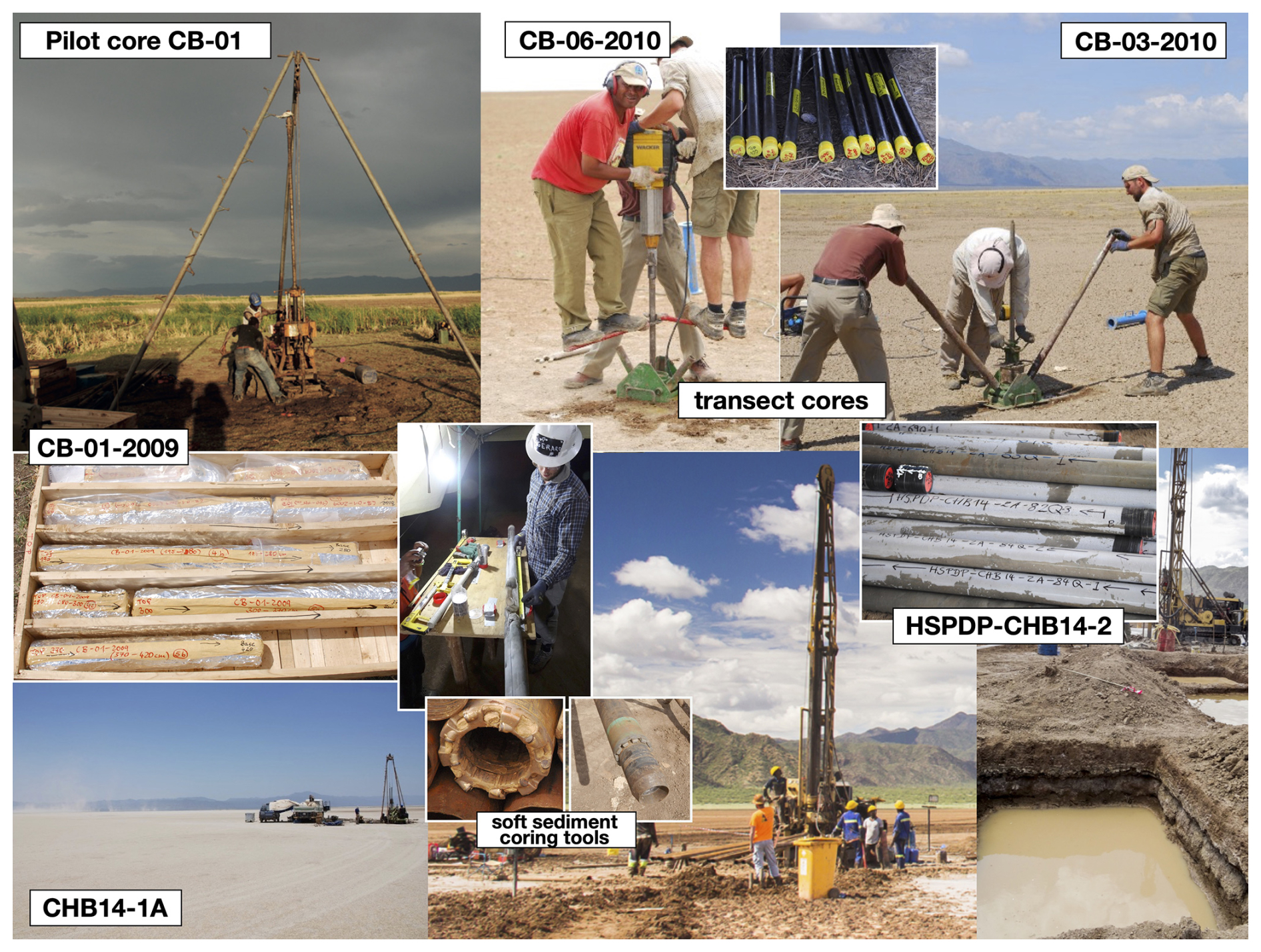
Figure 2Scientific coring campaigns in the Chew Bahir basin. Drilling pilot core CB-01-2009 close to the western basin margin in 2009, using a rotary single tube drill, with the cored sediment segments in the transport crate with a core diameter of 91 mm. Transect short cores across the basin were collected with a vibro-corer and smaller diameter liners. HSPDP deep-drilling campaign in November–December 2014, ∼ 3 km away from the western margin using duplicate coring strategy and soft-sediment coring tools (left: alien corer; right: extended nose corer, with non-rotating shoe). Six small ponds were excavated to store the daily required 40 000 L of drilling fluid per day. Recovered core segments were processed, weighed, measured and sealed for transport in the nearby science tent. Photos by the CHB science team.
This paper presents a compilation of information that has mostly been made available in a variety of prior publications, corresponding supplements and metadata on online platforms (e.g. the Open Science Framework, OSF) and is complemented by hitherto unpublished metadata. This contribution provides (a) a synopsis of the four coring campaigns in the Chew Bahir basin in December 2009, November 2010, March 2014 and November/December 2014 (e.g. Foerster et al., 2012, 2022; Viehberg et al., 2018; Schaebitz et al., 2021; Trauth et al., 2018); (b) a compilation of modern analogue studies on surface and exposed sediments in the Chew Bahir catchment (e.g. Fischer et al., 2020; Gebregiorgis et al., 2021); and (c) an overview of ∼ 25 in-depth proxy and data series studies (e.g. Foerster et al., 2018; Krueger et al., 2021; Lupien et al., 2022) providing context of concept-proven methodological approaches for the Chew Bahir site, building a comprehensive proxy toolbox for this sedimentary archive (Table 1).
Table 1List of Chew Bahir Project Field Campaigns since 2009, with funding, sediment cores, time span covered, research objectives and key publications.
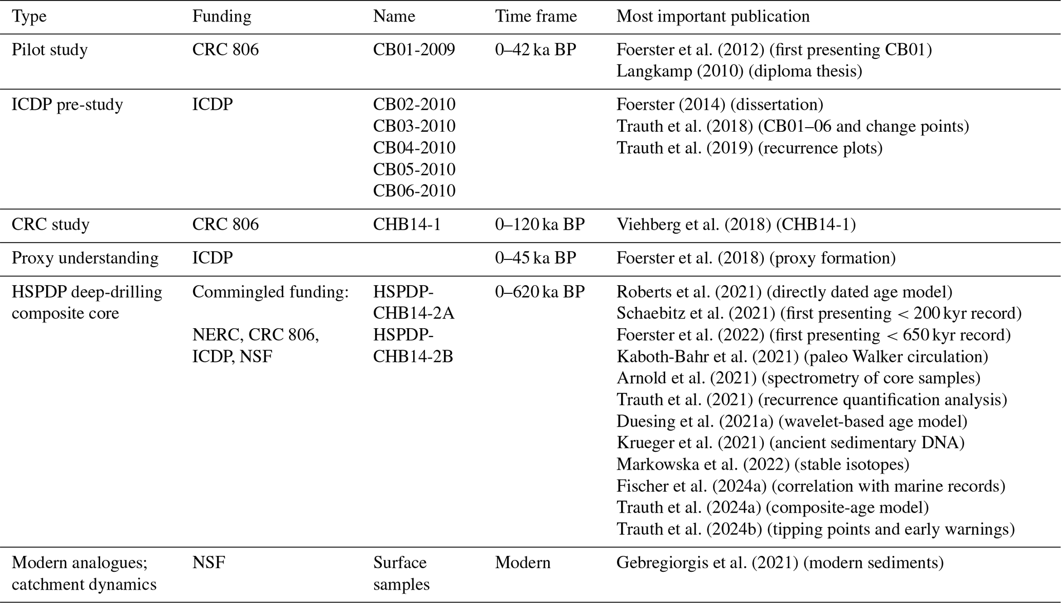
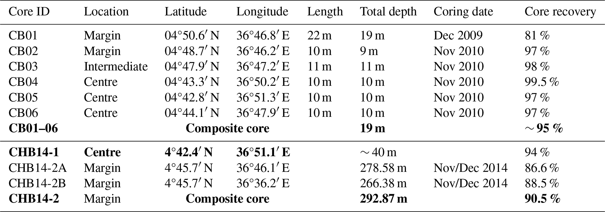
Table 2Cored locations within the Chew Bahir basin (longitudes and latitudes), core lengths, total depth of cored material below the lake floor, date of core collection and core recovery.
2.1 Project history starting in 2008
During the first ICDP-funded HSPDP workshop from 17 to 21 November 2008, passionate discussions ensued about the goals of the project and the selection of suitable drilling locations in eastern Africa. During a breakaway session on the selection of suitable sites, A. Asrat and M. Umer suggested an alternative high-potential new drilling location in the southern Ethiopian Rift – the Chew Bahir basin – although this site was not included in the original list of sites proposed by the HSPDP leaders. The proposal to include Chew Bahir in the HSPDP sites was informed by the intimate knowledge of the regional geology of the area, comprised of fluvio-lacustrine sedimentary deposits within the tectonic basin (Asrat et al., 2009) and the feasibility of potential field campaigns. The turning point in the decision to include Chew Bahir as an HSPDP site was the unpublished industry gravity survey data provided by the Ministry of Mines. These indicated the presence of 2–3 km thick sediment deposits in the basin (Asrat et al., 2009). The major advantages of this drilling location were (i) a very-well-understood regional geology with a detailed geologic map (Moore and Davidson, 1978; Davidson, 1983; Fig. 1b), (ii) gravity survey data which were available in 2008 and extensive seismic survey data conducted for oil exploration by Tullow Oil plc in 2014 (unpubl. industry data; Fig. 3) and (iii) its proximity to key archaeological sites with key hominin biological and cultural evolution records (e.g. Omo-Kibish, Vidal et al., 2022a; Ethiopian Highlands, Ambrose, 1998; Hildebrand and Brandt, 2010; Ossendorf et al., 2019; Mochena Borago, Brandt, 2012, 2017; Fig. 1). As a new HSPDP site included in the list of other previously intensely studied sites, additional funding should have been sourced for preliminary site characterisation of the Chew Bahir site.
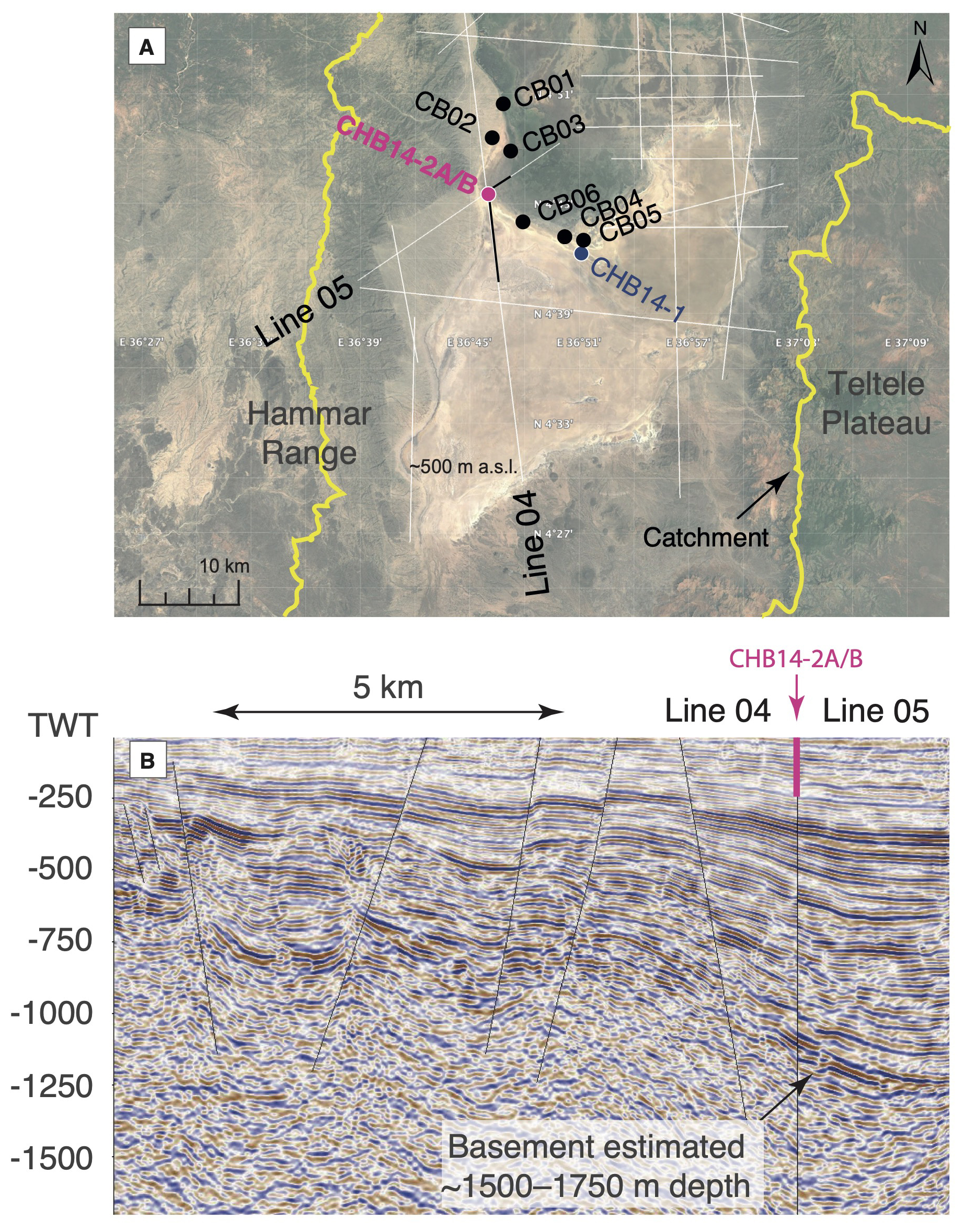
Figure 3Example of the selection of drill sites using seismic lines. Result of the evaluation of Tullow Oil seismic lines 04 and 05 to determine the best possible drill site for 2014 cores HSPDP-CHB14-2A and 2B. (a) Imagery © 2025 NASA, map data © 2025 Google, with the seismic lines (white), the cores from previous projects listed in Table 1 (black, red and green) and the outline of the Chew Bahir catchment (orange). (b) Seismic transect following Tullow Oil seismic lines 04 and 05, indicating the location of the ∼ 290 m twin cores HSPDP-CHB-14A/B at the insect of the two lines and the most likely depth of the basement in the western marginal area of the basin. TWT = two-way travel time of the seismic waves in milliseconds.
2.2 Drilling the pilot core CB01 (2009)
In order to test the potential of the new sedimentary archive and justify the idea of a deep-drilling campaign in Chew Bahir, the team of F. Schäbitz from Cologne University (Germany), M. Umer and A. Asrat from Addis Ababa University (Ethiopia), and H. F. Lamb from Aberystwyth University (United Kingdom) used the opportunity that research funding from the newly established Collaborative Research Centre 806 Our way to Europe was available to collect a first short sediment core: the pilot core CB01, in late 2009 (Foerster et al., 2012; Foerster, 2014; Tables 1 and 2). A layer of organic-rich bulk material was immediately sent for dating to the Beta Analytic Radiocarbon Facility in Miami, Florida. This first date of 13.6±0.15 cal kyr BP (Foerster et al., 2012) at about 7.35 m core depth was included in the first full proposal of the HSPDP, submitted in January 2010, demonstrating the potential of the site for further planned scientific study.
The Chew Bahir basin, which is one of the remotest places in the country, is administered under the jurisdiction of the Southern Nations Regional State, whose regional and zonal capitals are Hawassa and Jinka, respectively. Prior to coring CB01, permitting had to be completed with the relevant authorities at federal, regional and local levels. Fieldwork and drilling permits had to be obtained from the Federal Ministry of Mines, through facilitation of the host institution of the research, Addis Ababa University, and then from the regional and local authorities. In addition to the official government permits, the local Hammar elders provided a permit for accessing their land, while the day-to-day security of fieldwork in such a remote and occasionally volatile region was guaranteed by police security from the Turmi Police outpost. Owing to its remoteness, basic necessities (e.g. food and fuel) and all technical equipment had to be transported to the drill site from Addis Ababa or the towns along the route.
Finally, the optimal season with favourable weather conditions allowing easy access to the mudflat had to be considered during campaign planning. The optimal time window for coring was during the “dry” season between November and March (Nicholson, 2018). However, some intense but short orographic rain events, most common during April to October, occasionally happened during the supposedly “dry” season. The end of November to early February therefore represented the best time for accessing the Chew Bahir basin for drilling, as the playa surface becomes sufficiently dry to drive through. However, planning became more complicated during El Niño years, when southern Ethiopia received more than average rainfalls (Cai et al., 2025).
Pilot core CB01 was recovered from the western margin of the Chew Bahir basin close to the distal margin of the Weyto-Segen delta and near an extensive alluvial fan extending eastwards from the Hammar Range (Tables 1 and 2, Figs. 1–3). Heavy drill equipment was transported to the coring site across this fan along a relatively better graded track. A rotary single tube drill provided by Addis Geosystems Ltd. was used to drill the entire core without liner. The sediment record covers the uppermost ∼ 18.8 m of the lake deposits with a recovery rate of 81 %. Coring consisted of 19 individual drives without overlap (Foerster et al., 2012).
2.3 Coring a NW–SE transect (CB02 to CB06) through CB basin in 2010
In November 2010, a Cologne/Addis–Ababa/Aberystwyth team conducted a 5 d field campaign to collect additional short cores (CB02 to CB06) using a vibro-corer system (Foerster et al., 2012, 2015; Foerster, 2014; Tables 1 and 2, Figs. 1–3). While cores CB01 and CB02 were retrieved from the western margins of the mudflat, an area that is predominantly influenced by the fans from the Hammar Range and the Weyto River, cores CB04 to CB06 were collected from locations close to the geographic centre of the tectonic basin, in an area predominantly controlled by fluvio-lacustrine processes and currently the Segen River delta. The CB03 core sediments, from an intermediate location along the transect, were of mixed alluvial, lacustrine and fluvial origins, with the latter relating to the Weyto and Segen rivers. Together with the 18.8 m long pilot core CB01, these additional 9–11 m long cores (CB02 to CB06) provide a sedimentary record of a ∼ 20 km long NW–SE transect across the north-western part of the basin (Foerster, 2014; Trauth et al., 2018; Fischer et al., 2020; Gebregiorgis et al., 2021).
All of the six short cores (CB01 to CB06) yielded enough sample material and data on sediment type and sedimentation rates in the Chew Bahir basin (Foerster et al., 2012; Trauth et al., 2018), which were crucial for the subsequent deep-drilling project(s). The uppermost deposits (9–18.8 m) of the Chew Bahir basin are characterised by mostly fine-grained materials, such as clays, silty clays and silts, with few intercalated sand layers and carbonate-rich horizons. Furthermore, occurrences of diatoms, molluscs and fish bones were identified, which indicate varying lacustrine stages through time (Foerster, 2014). The sedimentation rates of the short cores show that during wet episodes, sedimentation rates vary between ∼ 0.5 and 0.7 mm yr−1, whereas much lower sedimentation rates of ∼ 0.1 mm yr−1 are typical for drier intervals such as the Last Glacial Maximum (LGM; Trauth et al., 2018). A general 6–7-fold increase of the mean sedimentation rate per year has been observed with the change to humid conditions in the basin. The mean annual sedimentation decreases from ∼ 0.7 mm yr−1 at the basin margin (CB01) to ∼ 0.2 mm yr−1 towards the basin centre (CB05).
The deep-drilling campaign at HSPDP Chew Bahir was originally scheduled for 2013, prior to the drilling activities of the HSPDP northern Awash basin site in northern Ethiopia in early 2014 (Cohen et al., 2016; Campisano et al., 2017). However, the planned deep drilling in late 2013 was cancelled on short notice prior to equipment mobilisation due to critical technical shortcomings of the drill rig provided, in violation of contractually defined specifications for the equipment. The drilling contractor was not able to provide adequate coring equipment in time for operations during the dry season of 2013/2014. Furthermore, forecasts of unfavourable weather conditions due to an impending ENSO/IOD extreme event, which could potentially result in severe flooding in eastern Africa, prompted the decision to defer deep-drilling operations in Chew Bahir for a full year, beyond the scheduled HSPDP drilling activities in the northern Ethiopian sites in northern Awash.
2.4 Coring the centre of the basin, 41 m core (March 2014)
Consequently, the deep-drilling project experienced a significant setback due to the forced postponement. To preserve the team's morale and fulfil the critical requirements of the CRC 806 within the context of a 200 kyr BP environmental scenario for human migration, the Cologne/Addis–Ababa/Aberystwyth team devised a short-term plan for an additional drilling operation in the basin's centre, in proximity to the short core CB06, scheduled for March 2014 (Figs. 1 and 2). Funded through CRC 806 resources and in close collaboration with the drilling team of Addis Geosystem Ltd., which had previously cored a pilot core CB01, it was feasible to plan, procure the necessary permits, mobilise the necessary equipment and execute a drilling campaign within a remarkably short time frame of only a few weeks' notice. As a result, a ∼ 41 m long core was recovered from the geographic centre of the Chew Bahir basin between 8 and 24 March 2014, pushing towards the end of the dry season. The known lower sedimentation rates towards the centre of the basin were considered suitable for obtaining a sediment record that would cover the <200 ka BP time interval relevant to the specific research questions of the CRC 806 (Viehberg et al., 2018).
The ∼ 41 m core HSPDP-CHB14-1 (4.7071° N, 36.8524° E) was recovered using a rotary single tube drill, as was used for the pilot core in CB01 in 2009 (Figs. 1 and 2). The core tube (inner diameter of 86 and 76 mm) itself was 2 m long, while the maximum protruding length was 1.8 m per core, run to ensure continuous material supply. The bore hole was stabilised by successive casings to a depth of 29 m below surface (m b.s.), and the hole remained stable to the last core section taken at a depth of ∼ 40 m b.s. However, the coring operations conducted using the land-based coring system were abruptly suspended after a few days' operation due to unforeseen and intense rainfall overnight that resulted in severe flooding of the saline mudflat. Subsequently, the fine lacustrine clays rendered the mudflat surface exceedingly slippery and also unstable. The drilling crew camped at the margin of the basin for security reasons, and after the flooding the coring site became inaccessible. After 2 sunny days without rain, the shallow water gradually receded, allowing the drilling crew and the science team to drive to the coring site and to demobilise equipment.
2.5 Coring duplicate deep HSPDP-CHB cores (November–December 2014)
After a thorough and difficult planning phase, which included importing lake-drilling tools from Kenya, passing through several hurdles at Ethiopian customs, securing the necessary drilling permits at various levels of government and traditional authorities, and mobilising a drilling rig from a mineral exploration site in western Ethiopia, the long-planned deep drilling in Chew Bahir was finally conducted in 2014. Two parallel long cores HSPDP-CHB14-2A and -2B were collected about halfway along the CB01–CB06 transect (Table 1, Figs. 1–3). The field logistics were prepared for coring operations, with drillers, engineers, scientists and camp logistics teams for day and night shifts, and could be started on the first day as scheduled. The selection of the core location was preceded by intense discussions regarding whether to drill the new parallel cores in the geographic centre of the ∼ 30 km wide and ∼ 100 km long basin with its 32 400 km2 catchment or to choose a location on the western edge of the basin.
The careful selection of the coring sites towards the western margin of the extensive basin was based both on scientific results from the pilot study but also on criteria of safety and accessibility. Site access proved to be a key consideration for frequent tank-truck deliveries of water required for drilling fluid. Project planning estimates called for <20 000 L of water/day, to be transported from a nearby well on the premises of the Tullow Oil camp, but continual lost circulation (fluid seeping into the formation) required more than double this volume (>40 000 d−1), which exceeded the Tullow well capacity. As a result, two water trucks with a capacity of 20 000 L each transferred water from the Weyto River (near the village of Erbore) ∼ 35 km away. Both trucks ran , where one truck delivered water at the coring site while the other was pumping water from the river, ensuring sustained provision of drilling fluids during the day and night shifts of drilling operations. On site, the water was stored in six hand-dug sumps built when the increased need for water emerged.
Coring multiple holes at the same site, considered to be well-established practices in IODP and ICDP sediment coring campaigns, provided a model for minimising stratigraphic gaps and creating a composite profile from the best sections of each core (e.g. Hodell et al., 2006; Koeberl et al., 2007; Zolitschka et al., 2009; Litt et al., 2012; see Fig. 4). Incomplete recovery is expected in unconsolidated sediments, with gaps particularly common between coring runs. Additional cores from the same site, with offset depth intervals, can recover the portions of the stratigraphy missing from one borehole. This allows the creation of a composite profile, or splice, from the best portions of each core, with tie points chosen based on clearly replicated beds, contacts or other features. Coring in Chew Bahir used two tooling systems and drill strings, both deployed from a wireline diamond coring drill rig. Specialised soft-sediment coring tools were used in the first phase. These tools are adapted from the designs used in decades of scientific ocean drilling, modified for the requirements of smaller drill rigs and successfully deployed in many lake-drilling campaigns since their initial use in 2000.
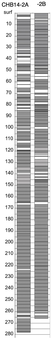
Figure 4HSPDP-CHB14-2A and -2B duplicate cores in metres below surface (m b.s.), showing core recovery (grey) and core loss (white), which could be largely compensated for in the second core.
Each of the tools can collect 3 m cores of 6.4 cm diameter in a plastic liner in a single run. The hydraulic piston corer (HPC) uses pressure generated by the mud pump to instantly advance the 3m run, yielding highest-quality cores in the softest sediments. When the lithology became too consolidated for the HPC, the extended nose corer (EXN) was deployed, using a non-rotating shoe that protrudes ∼ 15 cm below the coring bit to collect high-quality cores while rotating the drill string to overcome the friction at greater depths. As depth increases, or in lithified intervals unsuitable for the EXN, the alien corer (ALN) functions like a standard rock-coring tool (Harms, 2024). These three tool types use the same bottom hole assembly (BHA), drill string and bits, and therefore can be selected and efficiently deployed for the specific lithologies expected in each coring run, without changing other drilling equipment components. These tools were used until depths of 83.56 m in hole 2A and 87.38 m in hole 2B. At these depths, low core recovery and problems with liner integrity required a change to standard HQ3 rock-coring tools (triple tube with plastic core liner) and string. This change yielded a slightly smaller core (6.1 cm diameter) but significantly thinner bit kerf for more efficient coring with reduced core erosion. The HQ3 system was used for coring the remainder of each borehole, both of which ended in coarse-grained units with strong groundwater flow into the borehole.
Cores were received on site by project team members, who cut the core into sections ≤150 cm to fit lab instrumentation and storage requirements, and oriented, capped, sealed, labelled and documented the lengths and weights of each section, along with drilling notes and other relevant on-site information according to LacCore and ICDP protocols. These protocols generally resulted in two long sections for each core run and a short “corecatcher” section that was extruded from the shoe into a short piece of core liner. Drilling metadata were captured on site by LacCore staff using the LacCore Drill Site Database, which allows the efficient monitoring and tracking of drilling depths and all other required metadata in the context of soft-sediment lithologies (e.g. Kunkel et al., 2024) that do not provide the tactile feedback that drillers rely on for their standard workflows. The database user interface is aligned with on-site core handling workflows and the needs that arise at the interface of the science team and drilling personnel. It enables dynamic planning and implementation of twinned boreholes with offset depth intervals (Fig. 4) and provides real-time calculations for pipe numbers, start/stop marks, and information on previous core runs and sections. Accordingly, the drilling tool and drilling progress per drive could be adjusted rapidly in hole 2B to bridge core, section breaks and gaps in the 2A cores, and balance drilling progress (depth) with the avoidance of the risk of core loss in e.g. sandy layers (see Table Drilling notes, OSF). All drilling metadata captured in the database were uploaded to the ICDP Drilling Information System (DIS) and to the LacCore Facility data system for support of downstream lab-based core workflows, IODP standards-based depth scale generation and archiving in the core repository.
From a scientific perspective, the well-known sedimentation rates in addition to the available seismic data enabled us to meet the drilling target corresponding to a sediment age of 500 kyr, comprising duplicate core records 2A and 2B, in less than the proposed time (Schaebitz et al., 2021; Foerster et al., 2022; Figs. 1 and 2). Initial efforts to core a third hole 2C within the remaining time and funds were abandoned, when the second and last BHA was lost in hole 2B when hitting an aquifer at 266 m below surface.
2.6 Ground-truthing campaigns and modern analogue studies
Crucial to supporting the understanding of the climatic and environmental proxies within the new sedimentary archive, all Chew Bahir drilling campaigns were used to collect surface sediment rock and modern water samples from the catchment. Critically, those efforts were complemented by analogue studies of modern sedimentation, authigenic mineral formation and surface dynamics in the catchment (Gebregiorgis et al., 2021), and sampling along strandlines to provide context for a lake balance model (Fischer et al., 2020, 2021), as well as a study on water provenance and quantity (Markowska et al., 2022).
A comprehensive study to improve the understanding of spatiotemporal relationships between volcanism and tectonic geomorphology in the broadly rifted zone (BRZ; e.g. Ebinger et al., 2000), including the Chew Bahir basin (Erbello et al., 2024), has been valuable especially towards constraining the potential influence of tectonics on the sedimentary deposits in the deeper basin for future planned coring activities, indicating with thermal modelling that Quaternary deposits are unlikely to be affected by tectonic movement (Erbello et al., 2024). Current work includes the integration of hyperspectral satellite remote sensing and landscape modelling in combination with a geophysical survey to obtain critical information on surface redeposition, authigenic processes and provenance of sedimentary deposits to provide the essential background for a workshop and site selection discussions for a planned deep-drilling campaign to the bottom of the Quaternary.
3.1 Shipping, core opening and sampling of CHB14-2A and -2B
The two long cores CHB14-2A and -2B were shipped to the NSF Continental Scientific Drilling Facility (previously LacCore) at the University of Minnesota in Minneapolis as an essential part of the HSPDP project. Facility staff completed whole-core multi-sensor logging on a Geotek MSCL-S, including magnetic susceptibility, gamma density, natural gamma, p-wave velocity and electrical resistivity, and hosted the project team for the core opening, scanning, initial core description (ICD) and sampling party in April 2015.
The workflow for the HSPDP-CHB cores included core opening and preparation using core-liner splitting with vibrating cast saws, finished by manually pulling fishing line through soft sediment, with a band saw and diamond grit blade for compacted sediment or with a rail-mounted rock saw with continuous fresh deionised water flush for heavily compacted and lithified sediment. Split core archive halves were photographed with a Geotek MSCL-CIS (Geoscan IV) line-scan camera with cross-polarised light for glare-free images, inspected and lithologically characterised. Petrographic smear slides were made and inspected on a routine basis to characterise subtle changes at the microscopic level and to determine the composition of lithologies of particular interest. After description, the archive halves were scanned on a Geotek MSCL-XYZ split core logger for high-resolution (point) magnetic susceptibility (e.g. Trauth et al., 2021; Schaebitz et al., 2021), high-resolution colour reflectance spectra (Fig. 5) and data (e.g. Duesing et al., 2021a; Foerster et al., 2022) using a Minolta CM-2600d spectrophotometer. During this time, the working halves were sampled for discrete analyses to be performed at investigators' home institutions. Subsampling according to the sampling plan in routine 8–32 cm intervals of the composite profile was performed until ∼ 77 depth during the sampling party in April 2015. Multi-proxy sampling in the following resolution included paleomagnetic (4 cm), TN/TC/TS (8 cm), grain size (16 cm), ostracods (32 cm), isotopes (32 cm), pollen (32 cm), XRD (64 cm), 14C samples (32 bulk samples, top 25 m), aDNA samples (frozen), biomarkers, OSL (where applicable, entire core), tephra (where suspected) and fish bones (where present). Facility technicians continued sampling the remaining ∼ 200 m composite profile at a 32 cm resolution, yielding ∼ 14 000 subsamples in total.
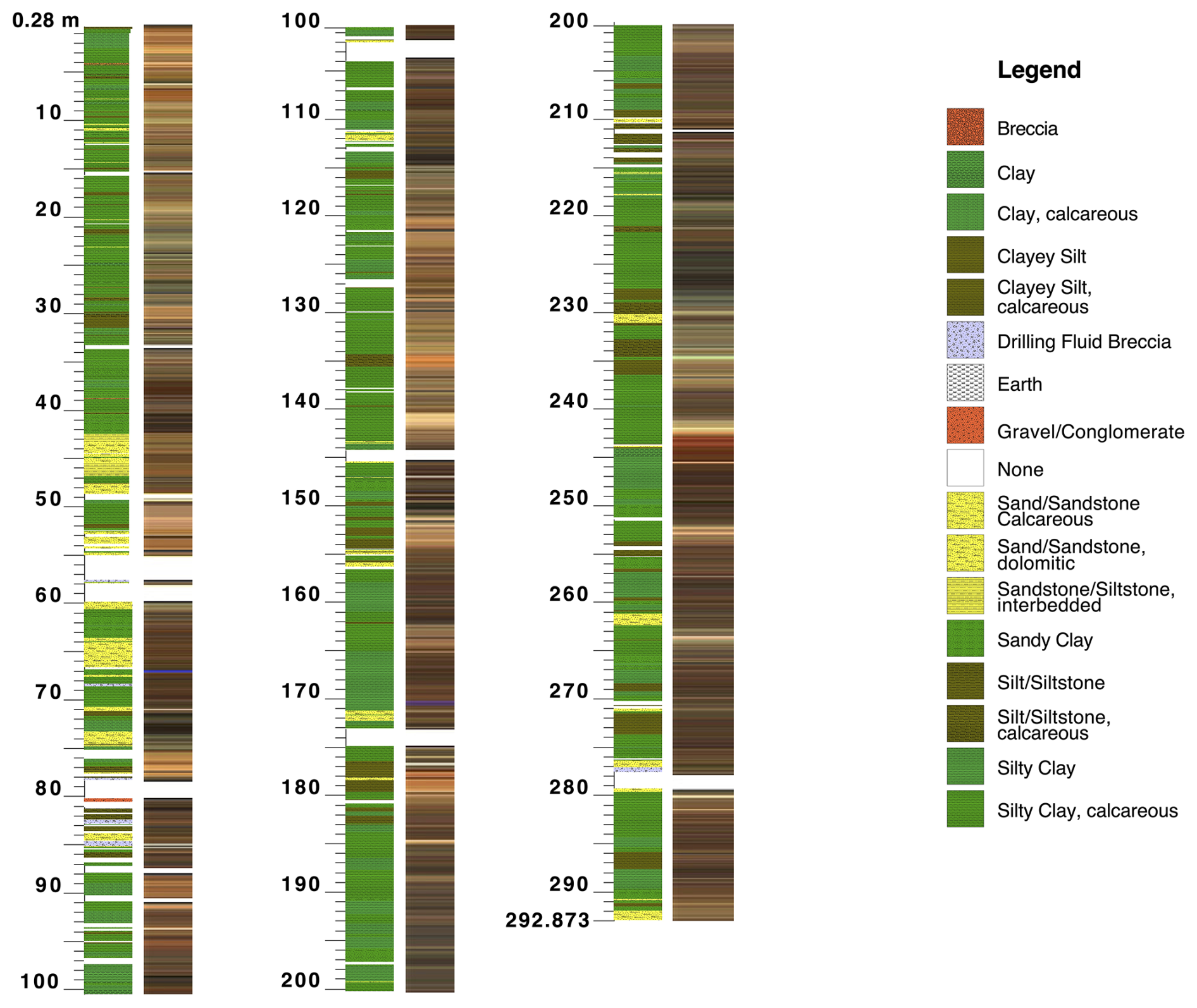
Figure 5Stratigraphical column of the composite core CHB14-2 (left) with colour profile (right) using line-scan RGB data. The profile shows the units as specific features as described during ICD and using the HSPDP description keys and the PSICAT programme. The full ICD description booklets, corresponding to high-resolution stratigraphical columns for CHB-14-2A and -2B, splice CHB14-2 and high-resolution colour profiles, are available under the project's OSF repository.
The project profited considerably from established protocols and workflows within the HSPDP, with HSPDP description keys for the lithology being extended to the occurrences of site-specific deposits. The workflow and depth terminology is largely based on IODP standards (e.g. IODP-MI, 2007), adapted to specific needs of smaller-scale lacustrine records (e.g. Ohlendorf et al., 2011). The core sections from both boreholes were opened in parallel to enable the parallel visual core lithologic description and establishment of a preliminary splice from available datasets. The loop sensor magnetic susceptibility data collected on whole cores were particularly helpful in correlation at this stage, but they integrate intervals of 8 cm (low resolution), and edge effects at the top/bottom of each section produce unreliable data. The split core MSCL data, collected with a magnetic susceptibility point sensor, yield data of higher resolution and quality, and replaced the loop sensor data for subsequent uses. Single borehole depths use the “scaled” depth convention, which fits core recovery >100 % into the drilled interval (equivalent to the IODP CSF-B depth scale), expressed in metres below the surface (m b.s.). The splice uses the composite depth scale based on the alignments and tie points (without scaling for core recovery), expressed in metres composite depth (mcd, equivalent to the IODP CCSF depth scale). As is typical, the splice exceeds the total depth, extending to 292.87 mcd.
3.2 Initial core description of CHB14-2A and -2B
Lithologic description of core CHB14-2A and -2B was done in parallel using the PSICAT version 2.0 software (https://cse.umn.edu/csd/psicat, last access: 25 September 2025) and the HSPDP description keys (Cohen et al., 2016) for the most common lithologies, following LacCore protocols (Campisano et al., 2017; Fig. 5). As is common in-core sampling parties, after line-scan image photographing, the freshly opened working halves of the core sections were set in front of the two-screen-wide display using the Corelyzer software (https://cse.umn.edu/csd/corelyzer, last access: 25 September 2025), showing high-resolution line-scan images of the sections alongside the MS data. The open sections were tested for carbonate content with 4 % hydrochloric acid, grain size composition and firmness, and inspected for cracks and potential disturbances. The description was documented for each of the 306 sections in 2A and 276 sections in 2B in the corresponding PSICAT datasheets, which resulted in the ICD booklets of the PDF core barrel sheets and exported tabular data, both available on OSF, closely describing each of the 582 core sections. This included the scaled core image, defined units, lithological intervals (clay, silt, sand) and additional symbols for concretions, microfossils, bedding, disturbances, lenses, etc. as well as a cm-by-cm description of core composition and quality. PSICAT uses the core and/or splice metadata to generate full stratigraphic columns for both cores and the splice, with lithological key and legend, all of which are available under the project's OSF repository (https://doi.org/10.17605/OSF.IO/M8QU5, Noren, 2022). Core CHB14-2A and -2B comprise clay and calcareous clay, clayey silt and calcareous clayey silt, breccia and drilling fluid breccia, gravel/conglomerate, sand/sandstone and calcareous sand, interbedded sand/silt, sandy clay silt, calcareous silt, silty clay and calcareous silty clay (Fig. 5). The symbols comprised burrows (branching, subvertical, vertical), calcite crystals, carbonate lenses, carbonate nodules, carbonate patches, concretions (unknown composition), cross-bedding (low angle), faults (normal, reverse, undetermined), fish bones, scales and teeth, fractures, gastropod shells, gastropod shell beds, laminated horizontal bedding (cm and mm), molluscs, mud clasts, mud cracks, ostracods, plant debris, pyrite, sand lenses, secondary infill, shell bed (of unspecified composition), shell material, undulatory parallel lamination and voids.
3.3 Definition of tie points and compositing
To get from two cores to one spliced record, the inter-correlation and consecutive merging (“compositing”) was required, using stratigraphic features recovered from one hole to align with the same features (colour changes, MS or other data peaks) in the other hole (IODP-MI, 2007; Fig. 6a). The documentation and processing of those common features followed routines and terminology described in the Correlator manuals (https://cse.umn.edu/csd/correlator, last access: 25 September 2025), using standardised splice tables for the documentation of tie points and affine tables for the core shifts required to yield the alignments, to build a new common depth scale for the emerging core, the composite depth. Finding and redefining tie points along those common features was done in multiple iterations as additional data became available, resulting in three major versions including sub-versions of the splice (Fig. 6a). The preliminary correlations in early April 2015 using Correlator (version 2.0.1) were based on the whole-core MSCL data and was particularly challenging, as the software does not differentiate the single sections of each drive, and signal noise related to the top/end of each section appeared as an in-core signal. The resolution of 10 cm was insufficient. This splice version was later improved during the core opening party by leveraging the lithologic features in the core face, resulting in version 1.2.
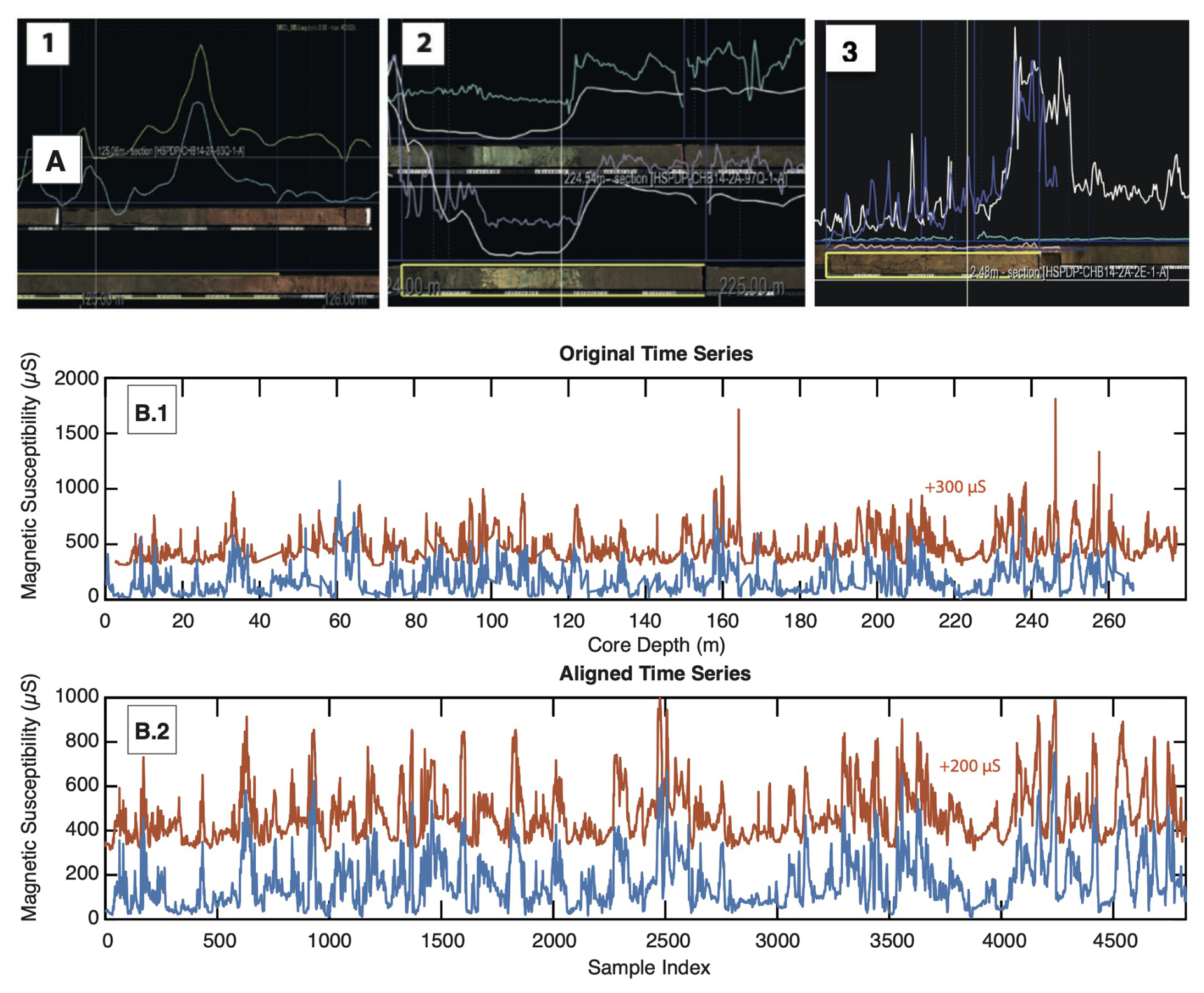
Figure 6For inter-core correlation of duplicate cores CHB14-2A and -2B, (A) similar features were visually identified using the Corelyzer Corewall software and a multi-proxy approach to find the best tie points in both cores and to build a composite core. The progressing reassessment of tie points was possible as new datasets became available: (1) low-resolution MS data, high-resolution line-scan images in April 2015, (2) plus high-resolution MSCL (October 2015), (3) plus XRF data (October 2016). Tie points were defined in the Correlator software. (B) An alternative automated correlation approach employed the MS data from both cores (B.1) and the dynamic time warping (DTW) algorithm to align the two records (B.2) (Sakoe and Chiba, 1978).
In October 2015, the availability of high-resolution MS data plus lithological features using high-resolution core images and ICD notes enabled the release of version 2 with the improved definition features that had previously been uncertain. In 2016, the first core scanning XRF elemental datasets resolved the remaining unclear features and the development of the final version 3, released in June 2017. As more data became available, the re-definition of suitable tie points progressed, and the number of tie point shifts decreased with each new version. However, each tie point shift inevitably meant a shift of the splice that caused (a) the change of the composite depth of the core and samples, and data points that were previously sampled/measured from the on-splice core sections to fall off-splice, resulting in (b) the need to define the splice-equivalent depths for the off-splice samples by ideally finding a matching sample in the twin core, which (c) caused additional work, confusion within the team and inevitable initial uncertainty. In the final version 3.0, ∼ 5 % of tie points in the correlation have depth uncertainties of 10–20 cm, with a quality marker system (documented on the OSF team space) signalling the maximum depth uncertainty (green, <5 cm depth uncertainty; yellow, 5–10 cm depth uncertainty; red 10–20 cm depth certainty).
Version 3.0 of the composite comprises 161 tie points and appends, and, due to the inclusion of XRF data for core correlation, the certainty of tie points could be maximally increased with the multi-proxy datasets available at that time. The multiple shifts of tie points with each new splice version meant that ∼ 10 % of all original discrete samples fell off-splice. In the case of the ∼ 14 000 samples that were pulled from the cores, 651 samples in 2A fell off-splice and 711 samples in 2B fell off-splice. For each of those 1362 off-splice samples, the equivalent depth on-splice in the parallel core had to be manually re-attributed. For this re-attribution of the matching depths (in metres composite depth, mcd) in the parallel core, the multi-proxy approach and again the internal quality-flag system were used in an effort to enable the transparent evaluation of age-depth certainty after sample analysis.
An alternative approach for the intercorrelation of the two cores was explored using dynamic time warping (DTW) and the high-resolution MS data from the split core MSCL logs. The time warping algorithm uses the unnormalised distance between the vectors to calculate the warping pass to align the two records (Fig. 6b). The results were less biased by specific peaks in the signal and were proficient in identifying similar patterns in both cores, but the algorithm was not able to disregard data artifacts that were known and could be excluded in the manual compositing approach, so the DTW inter-core correlation was abandoned. Instead, the DTW algorithm was later used to align the K records from cores CB02–CB06 with the K record from core CB01, a much closer constrained, processed and controlled dataset (Trauth et al., 2018).
3.4 XRF scanning
High-resolution XRF measurements of the composite profile were analysed in 0.5 cm resolution through the LacCore-associated XRF Lab at the Large Lakes Observatory (LLO) at the University of Minnesota Duluth campus. These scans were considerably delayed after core opening due to the shifted drilling schedule and historically high levels of core throughput and associated instrument demands, along with untimely failures of key instrument components (power supply, X-ray tube) and a pause for a planned upgrade to the detector. Following HSPDP protocols, a chromium (Cr) tube was used with a tube voltage of 30 kV, a current of 30 mA and scanning time of 10 s (Cohen et al., 2016; Schaebitz et al., 2021; Foerster et al., 2022). Further delays caused by erroneous scanning parameters required re-scanning 12 % of the measured sections. The complete XRF dataset finally became available in October 2016.
3.5 Data processing
Data curation and storage followed the LacCore protocols, using the Open Science Framework (OSF) online collaboration platform and data repository. Published datasets were linked with a digital object identifier (DOI), whereas working versions, drafts and other unpublished material remained reserved for the team. To integrate our understanding of compromised material, including cracks, section ends and voids, and other coring artifacts, a quality flag system sub-cm for two cores was defined, which could then be applied to the large scanning and logging datasets without trimming/removing outliers but using all core information to precisely disregard outliers with known causes. Subsequent XRF data processing of >55 000 data points per element and detailed time series analyses in preparation for the first publications revealed that, due to the long delays in between measuring and re-measuring sections, progressive ageing of the Cr tubes and replacement with new tubes had affected the results (Schlolaut et al., 2018; Foerster et al., 2022). Efforts through late 2018 to repair these strategic offsets mathematically were not successful. Re-scanning of the affected sections to correct for offsets in results was finally applied, along with the careful application of standards. For publication, all XRF data were then normalised by dividing elemental counts by coherence scattering and multiplying by a correction factor to compensate for the ageing of the Cr tube.
Datable material in the CB01–CB06 cores was identified and was found to comprise mostly biogenic carbonates and organic sediment, which were subsequently used for radiocarbon dating (Foerster et al., 2012; Trauth et al., 2018). In general, the cores contained datable deposits, without age reversals, apart from a few obvious outliers (Foerster et al., 2012; Trauth et al., 2018). The determination of a potential radiocarbon reservoir effect failed, however, due to a lack of sufficient parallel dating opportunities between aquatic biogenic carbonates and terrestrial-derived organic material (e.g. fossilised charcoal). Such an old carbon effect can occur when ages derived from (e.g. biogenic) carbonates would be slightly older if they had been compromised by fossil carbon (e.g. Felton et al., 2007; Kröpelin et al., 2008; Junginger et al., 2014), which has been discussed for African lakes (e.g. Garcin et al., 2012). Nevertheless, the influence of 14C-depleted runoff in Chew Bahir seems rather unlikely, considering that no consistent offset between the dated molluscs and the ages derived from organic bulk was evident (Bronk Ramsey, 2008; Bronk Ramsey et al., 2012). This is possibly caused by paleolake Chew Bahir, including groundwater in the hydrologic system repeatedly experiencing periods of hydrologic connection with the upstream cascading lake systems during wet phases, as model simulations of lake balances and Sr and O isotopic composition of surface and groundwaters suggest (Fischer et al., 2020; Markowska et al., 2022). The intermediate core CHB14-1 was dated using radiocarbon dating of bulk sediment samples as suitable discrete material was not found (Viehberg et al., 2018). Furthermore, the post-infrared infrared-stimulated luminescence (pIR IRSL) signal from polymineral fine-grain samples (4–11 µm) was used to determine luminescence ages for the sediments (Viehberg et al., 2018).
Radiometric age constraints for long cores CHB14-2A and -2B were based on 14C dating of ostracods, OSL dating of fine-silt-sized quartz grains and single-crystal total fusion (SCTF) dating of feldspars from pyroclastic layers within the core (Roberts et al., 2021). In addition, a volcanic ash layer identified in the core was correlated based on major and minor element geochemistry to a dated tephra found in outcrop at Konso, in the southern Main Ethiopian Rift, namely the Silver Tuff (Roberts et al., 2021). The ages generated are stratigraphically consistent, and Bayesian age-depth modelling incorporating 14C, OSL and ages. Tephrochronological data have been used to build an age model for the Chew Bahir cores (age model RRMarch2021, Roberts et al., 2021). An independent check on the accuracy of the chronology was provided by the subsequent identification of tephra from the 177 ± 10 ka Corbetti Ignimbrite at a depth equivalent to 178 ± 11 ka in the CB14-2B core (Vidal et al., 2022b). The 1-sigma confidence naturally increases in numerical value with increasing depth, ranging from <10 kyr in the uppermost 50 m (corresponding to ∼ 100 kyr BP) and 10–35 kyr below 50 m composite depth (∼ 100–620 kyr) (Roberts et al., 2021). A combined age-model (Trauth et al., 2024) unites the directly dated Bayesian model (Roberts et al., 2021) and orbital tuning approaches (e.g. Duesing et al., 2021a), and therewith enables the less constrained sections of the core to be tied into a higher resolution age–depth relationship.
The first publication of the dataset of CB01 (2009) dealt with only a single core (Foerster et al., 2012). In the later publication by Trauth et al. (2015), this core was supplemented with one of the cores obtained in 2010, CB03. The K+ record between 11 and 4 kyr BP of core CB01 was used for the analysis of stability vs instability because it represents the most complete and detailed record of the Mid-Holocene wet–dry transition in the Chew Bahir basin. Between 9.8 and 9.1 kyr BP, a gap in the core CB01 could be filled with the corresponding piece from the adjacent core CB03. The most recent publications on the short cores used the information from all cores CB01–06, which were aligned using dynamic time warping (DTW) before using a principal component analysis (PCA) to extract a common regional climate signal from the six K+ records (Trauth et al., 2018). Dynamic time warping, included in MATLAB as the dtw function (MathWorks, 2025), stretches two time series onto a common set of points in time such that the sum of the Euclidean distances between corresponding points is as small as possible (Sakoe and Chiba, 1978; Paliwal et al., 1982). The medium-length core CHB14-1 did not have a twin core, so this was analysed and interpreted individually (Viehberg et al., 2018).
In a third step, the advantages of short cores with those of long cores were combined in a comprehensive composite (Trauth et al., 2018, 2024). This approach is based on the assumption that the short cores are of a higher quality for the time interval <47 kyr BP (Foerster et al., 2012; Trauth et al., 2018, 2019), with some uncertainties between 20 and 47 kyr BP (Trauth et al., 2018), while the long twin core has a very good chronology for the time interval >20 kyr BP (Schaebitz et al., 2021; Foerster et al., 2022). Therefore, the two datasets were merged at 20 kyr BP after the time series had been previously adjusted in the measures of central tendency and dispersion (Trauth et al., 2018, 2024).
5.1 Ideal drilling location, drilling strategy and drilling time
After 15 years of coring, field campaigns and intense (interdisciplinary) analytical research, coupled with the effort to establish Chew Bahir as a high-quality climate archive, it is prudent to critically reflect and revise decisions and strategies regarding scientific drilling. The collection of several short sediment cores arranged along a transect from the western basin margin to its centre proved to be a winning strategy as it provided a substantial foundation for the work at this site, both scientifically and logistically. First, we successfully tested the stability and accessibility of the playa ground, enabling us to assess potential logistical challenges that may arise during bigger drilling operations. These include the accessibility of the drilling site in the event of a medical or technical emergency, the availability of water, and the time required to mobilise and demobilise the drilling rig and associated equipment. For all these aspects, a drilling location close to the basin margin and near to the access road is preferable.
Second, we learnt that under dry weather conditions in the middle of the dry season, the playa surface is easily accessible in most of its parts and one can drill nearly everywhere in the basin, with both physical/logistical and security risks increasing by further approaching the eastern edge of the basin. After the unforeseen weather conditions in late March 2014, when unexpected heavy rains flooded the CHB14-1 drill site in the centre of the basin, threatening the loss of drilling equipment and core, and risking the team's safety, it was a prudent decision to strategically position the site for the deeper drilling and the camp closer to the western margin.
Scientifically, the higher time resolution and the more constrained processes controlling the sediment composition closer to the western margin were convincing arguments for an off-centre drilling location. The known sedimentation rate along the transect enabled us to roughly calculate and narrow down the best-suited spot in the basin to achieve the drilling target of 500 kyr for the first hole of CHB14-2. The extensive industrial seismic datasets that were shared by Tullow Oil plc were also extremely helpful in being able to identify a more specific drill site, with undisturbed deep sediment layers, avoiding tectonic displacements and discontinuities in the sediment. Evidently, a degree of fortuitousness is invariably required to pinpoint the precise drill site within the designated most favourable region. The two locations we eventually chose for holes 2A and 2B in the field met our expectations of the targeted time frame and sediment characteristics to achieve the desired quality of the sedimentary record.
The planned drilling strategy for duplicate coring was achieved and paid off: after reaching a depth of 278.58 m b.s. in hole CHB14-2A (17 November 2014), only 11 d into the 6-week drilling schedule, a new hole (2B) for the duplicate core was set up 20 m away. Coring this duplicate profile 2B enabled the gathering of more comparable sediment material that facilitated filling the gaps discovered in the first drill profile. In 2014, we could not import all the necessary items for down-hole logging, but the additional profile later helped significantly to compensate for the lack of down-hole logging data and helped to understand the different sediment layers and to identify and exclude coring artifacts. During coring operations of the second hole, we continuously optimised the choice of tools, protocols and depth intervals, learning from the twin profile what material to expect. This dual core strategy allowed borehole and core CHB14-2B to overlap the first profile, meaning we were able to close most gaps from CHB14-2A and achieve a higher recovery rate (∼ 90 %), thereby gaining a lot of insight into the sediment characteristics, which has proven to be essential for the robust construction of a near-continuous composite core.
Scientifically, the pre-study provided detailed information about the nature of the sediments, depositional processes in the basin and spatial variations in the sedimentation rate. Also, the pre-study enabled us to test hypotheses on the feasibility of analysing standard proxies and chronometers in the sediment cores. These preliminary investigations made it clear that the organic content is generally very low in the cored deposits and therefore a number of biological and biochemical proxies are not continuously available, such as pollen and diatom assemblage (Foerster et al., 2012, 2022). One exception, at least in the upper (<70 m) core sections, was the investigation of ancient DNA (aDNA), which provided insights into the flora and fauna, particularly those groups of organisms in Chew Bahir that are not documented by the preservation of skeletal remains (Krueger et al., 2021).
Due to the lack of preservation of biological signals, physical, mineralogical and chemical characteristics of the sediments became key datasets underpinning the study of this site (e.g. Foerster et al., 2018; Duesing et al., 2021b; Schaebitz et al., 2021; Kaboth-Bahr et al., 2021). An early and surprising discovery during the investigation of the short cores was the smectite–illite transformation with increasing pore water alkalinity and, for this reason, potassium (K) as an indicator of a dry climate, not, as expected, a humid climate and increasing feldspar weathering in the catchment area as the dominant process (Foerster et al., 2012, 2018). Here, an alternative interpretation of the K proxy had to be defended against stubborn prior knowledge (Foerster et al., 2012) before a detailed investigation of the sediments eventually revealed the proxy-forming process (Foerster et al., 2018).
The unusual composition of the Chew Bahir sediments in the terminal sink of a catchment with mixed granitoid crystalline and basaltic volcanic rocks also allowed us to test for the limits of yet innovative proxies on short and long cores, such as advanced hyperspectral analysis (Arnold et al., 2021), leaf wax hydrogen isotopes (Lupien et al., 2022) and oxygen isotopes in authigenic clay minerals (Gebregiorgis et al., 2021). Using and integrating the full array of available chronometers (14C, OSL and ; Roberts et al., 2021; Vidal et al., 2022a, b) in combination with different age/depth modelling approaches (wavelet-based MUBAWA, Duesing et al., 2021a; composite combined tuned/directly dated age model, Trauth et al., 2024) for age-depth control helped to strengthen the transparent discourse addressing chronological gaps and naturally occurring uncertainties in an informed way.
5.2 Lessons learned
Our prior experiences at Chew Bahir will inform our planning and handling of organisational and technical considerations in future drilling projects. One important logistical issue that emerged during ongoing drilling operations was the enormous amount of water required as drilling fluid to ensure continuous drilling operations. In Chew Bahir, the pre-mobilisation estimates started with 10 000 L d−1, but it quickly became apparent that this was not sufficient, and up to 40 000 L d−1 was required, consistent with other subsequent paleolake-drilling project performance data using similar drilling tools and protocols. To accurately assess the correct amount of water needed and thus be able to plan beforehand the required infrastructural and logistical measures is crucial to the success of any drilling project, particularly in coring sites where the available water sources are several tens of kilometres away, as is the case in the Chew Bahir basin.
The decision to core close to the western margin was both scientifically and logistically appropriate. Driving the short distance between the drilling site and the camp site on the alluvial fan was manageable even after rain events. The majority of the drilling gaps encountered in the initial core were attributed to sandy layers. However, these gaps were closed by selecting the appropriate drilling tool (HPC) prior to reaching the desired depth in the second core (as outlined in Sect. 2.5). By duplicate coring, we were able to document key intervals in the sedimentary sequence that were difficult to retrieve, such as MIS 5. Notably, the utilisation of the HPC tool in core 2B, particularly in challenging core depths previously identified in core 2A, facilitated the recovery of valuable core depths. This was achieved by penetrating the sediment at a slow pace rather than employing rotation-based drilling, which would have resulted in longer drives. Consequently, sand-rich deposits could be retrieved in remarkably short drives, contributing to the high combined recovery rate of CHB14-2B.
Given the remote location and numerous issues encountered during drilling, the depths and core recovery achieved represent a significant accomplishment. However, the maximum depths were short of the original target (400 m b.s.) and are broadly consistent with the maximum depths reached at other HSPDP sites (Cohen et al., 2016) and during the similar Olduvai Gorge Coring Project (Njau et al., 2021), despite deeper targets. Common factors that contributed to reduced depths relative to site-specific goals included borehole instability due to coarse sand/gravel units or swelling clays, strong groundwater flow into the borehole and logistical limitations requiring operational pauses. This was due to insufficient water for drilling, a lack of spare parts on site and (at some sites) drilling contractor inexperience. These results demonstrate the limits in paleolake drilling of using small (∼ 14 T 200 HP) drill rigs, minimal drilling engineering, and a lightweight equipment and parts supply. Ongoing efforts in the Chew Bahir (https://www.icdp-online.org/projects/by-continent/africa/deepchb-ethipia/, last access: 27 February 2026) and Turkana (Beck et al., 2024) basins that build on HSPDP outcomes, and similar projects at other localities (e.g. Giaccio et al., 2024), aim to drill deeper and will likely need to mobilise larger rigs and prepare more detailed plans for coring diameters, casing, mud engineering, pressure management and on-site parts inventories.
5.3 Duplicate = double quality?
The clear advantage of having more than one core has been highlighted, including the higher overall recovery rate, the optimised choice for coring tools, the availability of more sample material and comparability between profiles for sediment characterisation. The primary challenge in constructing a composite core from lacustrine sediments might be the choice of strategies and priorities during the compositing process of (or merging) the cores. While filling large gaps in the composite record is clearly a priority, one must keep in mind that with every tie point chosen in inter-core correlation, a natural uncertainty and bias is introduced into the record. In most cases, the comparable sediment features employed to transition between one core and the other (e.g. improved core quality, enhanced record continuity, among other reasons) are distinct. When multiple sedimentary features, such as sediment colour, elemental values or composition changes, exhibit concordance, it indicates a favourable match and suggests that the samples likely represent the same stratigraphical unit.
However, in some cases, none or only one of the features for tie point identification ensure the provision of adequate and reliable information, resulting in increased uncertainty. Hence, reducing the number of tie points to the absolute minimum might be a sensible trade-off as it would minimise the strategic introduction of hidden uncertainty. Hence, bridging larger gaps is certainly helpful, but risking the choice of unclear tie points for the sake of avoiding section breaks or beginning and ending of individual drives has to be carefully considered. Furthermore, this is always a matter of scale; for example, introducing a 20 cm stratigraphical uncertainty might still be better than having an 8 m long gap in the profile, but introducing a 5 cm stratigraphical uncertainty is an unfortunate prioritisation for avoiding 2 cm of disturbed sediment.
The number of revisions of the chosen tie points, and therewith the splice, should also be kept to a critical minimum and as closely together as possible time-wise. Each newly available dataset supporting the identification of similar stratigraphical features helps to improve the certainty of tie points, but with each shift and new splice version, the whole composite profile changes inevitably, causing confusion in the science team. The risk that team members work on different versions increases with the number of splice shifts. A considerable disadvantage and source of errors is also the inevitable creation of off-splice samples: samples that were extracted from the original splice and potentially analysed. Finding and communicating the correct new depth for each of the samples is a challenge that can easily become an error source across publications if left unchecked. The off-splice samples employed for age determinations pose the greatest potential for complications. Each uncertainty associated with identifying the appropriate splice-equivalent depth for a sample introduces additional uncertainty into the age-depth model. For all samples that were identified for chronology, extra care was taken that the correct depths were attributed to the sample (Roberts et al., 2021). On the positive side, the dual coring approach offers the advantage of providing additional material in the twin core, which is particularly beneficial in several critical cases. This additional material can be sufficient and suitable for dating and analysing proxies (Roberts et al., 2021; Duesing et al., 2021a; Trauth et al., 2024).
A good future compromise for maximising the advantages of duplicate coring and minimising the error sources of compositing could be the comparison of automated and manual alignment tools for cores and potentially combining both approaches, such as a DTW-assisted manual alignment that would help to constrain user-specific biases in instances of known outliers and artifacts but using pattern recognition algorithms where appropriate.
5.4 Collective learning and project communication
The establishment of a structured framework for regular meetings has been demonstrated to be pivotal to the project's success over the past 15 years. This framework facilitates the exchange of novel findings, results and evolving enquiries, thereby ensuring the continuous advancement of the project's objectives. Providing context for new directions and interpretations has been essential. Effective communication within the project and across all sub-projects, coupled with transparent data sharing, is crucial for the seamless integration of numerous datasets into a comprehensive site and proxy understanding. However, this integration can pose challenges in large international scientific teams.
The annual Chew Bahir meetings, held in Cologne (2015), Aberystwyth (2016), Potsdam (2017), Arba Minch (2018) and Neandertal (2019), and eventually two online meetings (2020 and 2021), represented a valuable framework for maintaining a structured exchange and the creation of future visions. The long-term curation of results and samples via the LacCore team was a cornerstone and important to make scientific results, experiences and metadata sustainably available. Interdisciplinary communication among teams conducting diverse analyses globally, spanning various cycles of doctoral projects and employment contracts, yielded significant benefits. However, it also relied on the consistent implementation of project pillars as well as the willingness to share, adapt and critically revise some earlier decisions as the project evolved and further information came to light.
The deep-drilling project described here in the Chew Bahir basin in southern Ethiopia, embedded in the ICDP-HSPDP project as one of five drilling locations in Ethiopia and Kenya, followed a typical ICDP course during the actual drilling from 2009 to 2014 and the subsequent analysis and evaluation of the sediment cores obtained. The project was led by a multi-national and multi-disciplinary team headed by A. Asrat, H. F. Lamb, F. Schäbitz and M. H. Trauth, who divided the tasks of planning, procuring the necessary funds, conducting fieldwork and laboratory work, and publishing the results according to their respective strengths and areas of expertise. During the course of the project, the team was reinforced by an additional ∼ 40–60 international scientists, many at the start of their careers, who matured significantly during the course of the project and were thus able to raise further project funds to lead their own scientific investigations and publish these results.
The project team succeeded in adapting the project strategy throughout its duration in line with current requirements and new challenges. The decision to study several short sediment cores along a transect from the western margin to the centre of the Chew Bahir basin was scientifically and logistically beneficial. The low organic content and limited availability of certain proxies (e.g. pollen, diatoms) led to a focus on physical, mineralogical and chemical characteristics. Duplicate coring was successful in gathering more comparable sediment material, filling gaps and increasing the recovery rate (∼ 90 %). The duplicate coring strategy paid off, allowing for the collection of more data and insights about the sediment characteristics. The decision to core close to the western margin minimised logistical challenges and allowed for a higher time resolution. The use of duplicate coring and careful consideration of tie points and splice revisions minimised errors and uncertainties in the composite profile. The project's success depended on careful planning, regular meetings, the exchange of findings and the transparent sharing of results across teams and disciplines.
All datasets and figures related to this paper are available online for download on the OSF repository (https://doi.org/10.17605/OSF.IO/M8QU5, Noren, 2022). This comprises CHB14-2 core colour profiles, core lithologic descriptions, core metadata (including field notes and splice metadata with affine and splice tables) and the high-resolution splice stratigraphical column. Other CHB14-2 datasets like MSCL data, PC2 of colour reflectance, grain size and XRF data are also accessible online under the same doi in the corresponding folder.
VF, FS and MHT prepared the paper and created the figures, contributing equally to the work. All other authors contributed to the paper, each according to their expertise and role in the project described here.
The contact author has declared that none of the authors has any competing interests.
Publisher's note: Copernicus Publications remains neutral with regard to jurisdictional claims made in the text, published maps, institutional affiliations, or any other geographical representation in this paper. The authors bear the ultimate responsibility for providing appropriate place names. Views expressed in the text are those of the authors and do not necessarily reflect the views of the publisher.
This paper is dedicated to our much-missed colleague Andrew “Andy” S. Cohen, who initiated HSPDP and inspired all involved projects and teams. His wish for a paper that wraps up our experiences with coring twin cores – instead of just one – was our decade-long pending homework. We honour his driving enthusiasm and ability to celebrate science in a way that continues to propel projects for the future. We wish also to honour Mohammed Umer who was one of the original proponents of the HSPDP and one of the original drivers of the Chew Bahir Drilling Project before his untimely death on 27 November 2011.
We thank the federal, regional and local Ethiopian authorities for supporting our research in Ethiopia and for providing us with the required permits for drilling operations in the Chew Bahir basin. We thank the Hammar people for giving us access to their land. The Addis Ababa University is greatly thanked for hosting the research and facilitating all communications with the Ethiopian authorities. We would like to thank Addis Zeleke and his team for carrying out the drilling campaigns to obtain cores CB01 and CHB14-1. We thank DOSECC Exploration Services, especially Anthony Vecchiarelli and Steve Cole, for drilling supervision and Ethio Der pvt. Ltd. Co. for drilling the long cores CHB14-2A and -2B, and providing logistical support during all drilling operations. Initial core processing, sampling and archiving were conducted at the US National Lacustrine Core Facility (LacCore, now the Continental Scientific Drilling Facility) at the University of Minnesota. Special thanks go to the LacCore team supporting the core opening party and field operations: Kristina Brady Shannon, Mark Shapley, Brian Grivna, Ryan O'Grady and Jessica Rodysill. We thank our colleagues Sarah J. Davies, Jonathan R. Dean, Melanie J. Leng, Emma J. Pearson, Catherine Martin-Jones, Hubert B. Vonhof and Monika Markowska for their inspiring discussions on proxy understanding. We thank Raphael Gromig, Rebecca Nagel, Jan Schüürman, Gerrit Dorenbeck, Jonas Urban and Meklit Yadeta for their support during the field campaign and sampling party.
This is publication #58 of the Hominin Sites and Paleolakes Drilling Project.
Support for the HSPDP has been provided by the National Science Foundation (NSF) (grant nos. 1338553, 1123000, 1123942, 1123980, 0949962, 1241859, 1521882, 1241790, 1241530, 1241742, 1241615, 1241025, 1241815, 1241595, 1241879, 1462297, 1462347) and the International Continental Drilling Program (ICDP). Support for the CBDP has been provided by German Research Foundation (DFG) through the Priority Program SPP 1006 ICDP (SCHA 472/13 and /18, TR 419/8, /10 and /16, FO 734/2, and TI 349/14 and /18) and the CRC 806 Research Project Our Way to Europe project no. 57444011. Support has also been received from the UK Natural Environment Research Council (NERC grant NE/K014560/1). C. L., A. A. and C.-M. V. received support from the Cambridge-Africa ALBORADA Research Fund (“Volcanic tie-lines between records of past climates and early modern humans in Ethiopia, 2019–21”). S. K. B. has received financial support from the University of Potsdam Open Topic Postdoc Program. The Berkeley Geochronology Center received support from NSF grant EAR1322017.
This paper was edited by Hendrik Vogel and reviewed by Sebastian Schaller and R. Bernhart Owen.
Amante, C. and Eakins, B. W.: ETOPO1 1 Arc-Minute Global Relief Model: Procedures, Data Sources and Analysis. NOAA Technical Memorandum NESDIS NGDC-24, National Geophysical Data Center, NOAA, https://doi.org/10.7289/V5C8276M, 2009.
Ambrose, S. H.: Late Pleistocene human population bottlenecks, volcanic winter, and the differentiation of modern humans, Journal of Human Evolution, 35, 115–118, 1998.
Arnold, G. E., Foerster, V., Trauth, M. H., Lamb, H., Schaebitz, F., Asrat, A., Szczech, C., and Günter, C.: Advanced hyperspectral analysis of sediment core samples from the Chew Bahir Basin, Ethiopian Rift, in the spectral range from 0.25 to 17 µm: support for climate proxy interpretation, Frontiers in Earth Science, 9, 606588, https://doi.org/10.3389/feart.2021.606588, 2021.
Asrat, A., Bates, R., Berger, G., Beyene, Y., Brandt, S., DeGusta, D., Duller, G., Ebinger, C., Endale, T., Hart, W. K., Hildebrand, E., Katoh, S., Kidane, T., Lamb, H., Leng, M., Lezine, A.-M., Marshall, M., Morgan, L., Pearce, N., Prave, T., Renne, P., Schaebitz, F., Strecker, M., Suwa, G., Tadesse, K., Tadesse, T., Trauth, M. H., Umer, M., Vogelsang, R., White, T., WoldeGabriel, G., and Zeleke, A.: The Chew Bahir Drilling Project: A Plio-Pleistocene Climate Record from the Southern Ethiopian Rift, a Crucible of Human Evolution. Proposal for the ICDP-HSPDP (Hominin Sites and Palaeolakes Drilling Project), 1–8 pp., 2009.
Beck, C. C., Berke, M., Feibel, C. S., Foerster, V., Olaka, L., Roberts, H. M., Scholz, C. A., Cantner, K., Noren, A., Kiptoo, G. M., Muirhead, J., and the Deep Drilling in the Turkana Basin (DDTB) project team: ICDP workshop on the Deep Drilling in the Turkana Basin project: exploring the link between environmental factors and hominin evolution over the past 4 Myr, Sci. Dril., 33, 93–108, https://doi.org/10.5194/sd-33-93-2024, 2024.
Brandt, S. A., Fisher, E. C., Hildebrand, E. A., Vogelsang, R., Ambrose, S. H., Lesur, J., and Wang, H.: Early MIS 3 occupation of Mochena Borago Rockshelter, southwest Ethiopian highlands: implications for Late Pleistocene archaeology, paleoenvironments and modern human dispersals, Quaternary International, 274, 38–54, https://doi.org/10.1016/j.quaint.2012.03.047, 2012.
Brandt, S. A., Hildebrand, E. A., Vogelsang, R., Wolfhagen, J., and Wang, H.: A new MIS 3 radiocarbon chronology for Mochena Borago Rockshelter, SW Ethiopia: implications for the interpretation of Late Pleistocene chronostratigraphy and human behavior, Journal of Archaeological Science Reports, 11, 352–369, https://doi.org/10.1016/j.jasrep.2016.09.013, 2017.
Bronk Ramsey, C.: Deposition models for chronological records, Quaternary Sci. Rev., 27, 42–60, https://doi.org/10.1016/j.quascirev.2007.01.019, 2008.
Bronk Ramsey, C.: Deposition models for chronological records, Quaternary Science Reviews, 27, 42–60, https://doi.org/10.1016/j.quascirev.2007.01.019, 2017.
Bronk Ramsey, C., Staff, R. A., Bryant, C. L., Brock, F., Kitagawa, H., van der Plicht, J., Schlolaut, G., Marshall, M. H., Brauer, A., Lamb, H. F., Payne, R. L., Tarasov, P. E., Haraguchi, T., Gotanda, K., Yonenobu, H., Yokoyama, Y., Tada, R., and Nakagawa, T.: A Complete Terrestrial Radiocarbon Record for 11.2 to 52.8 kyr B.P., Science, 338, 370–374, doi:10.1126/science.1226660, 2012.
Cai, W., Reason, C., Mohino, E., Rodríguez-Fonseca, B., Malherbe, J., Santoso, A., Li, X., Chikoore, H., Nnamchi, H., McPhaden, M. J., Keenlyside, N., Taschetto, A. S., Wu, L., Ng, B., Liu, Y., Geng, T., Yang, K., Wang, G., Jia, F., Lin, X., Li, S., Yang, Y., Wang, J., Li, Z., Wilfried, P., Zhou, L., Zhang, X., Engelbrecht, F., Li, Z., and Mutemi, J. N.: Climate impacts of the El Niño–Southern Oscillation in Africa, Nature Reviews Earth & Environment, 6, 503–520, https://doi.org/10.1038/s43017-025-00705-7, 2025.
Campisano, C. J., Cohen, A. S., Arrowsmith, J. A., Asrat, A., Behrensmeyer, A. K., Brown, E. T., Deino, A. L., Deocampo, D. M., Feibel, C. S., Kingston, J. D., Lamb, H., Lowenstein, T. K., Noren, A., Olago, D. O., Owen, R. B., Pelletier, J. D., Potts, R., Reed, K. E., Renaut, R. W., Russel, J. M., Russel, J. L., Schäbitz, F., Stone, J., Trauth, M. H., and Wynn, J. G.: The Hominin Sites and Paleolakes Drilling Project: high-resolution paleoclimate records from the East African Rift System and their implications for understanding the environmental context of hominin evolution, PaleoAnthropology, 2017, 1–43, 2017.
Cohen, A., Campisano, C., Arrowsmith, R., Asrat, A., Behrensmeyer, A. K., Deino, A., Feibel, C., Hill, A., Johnson, R., Kingston, J., Lamb, H., Lowenstein, T., Noren, A., Olago, D., Owen, R. B., Potts, R., Reed, K., Renaut, R., Schäbitz, F., Tiercelin, J.-J., Trauth, M. H., Wynn, J., Ivory, S., Brady, K., O'Grady, R., Rodysill, J., Githiri, J., Russell, J., Foerster, V., Dommain, R., Rucina, S., Deocampo, D., Russell, J., Billingsley, A., Beck, C., Dorenbeck, G., Dullo, L., Feary, D., Garello, D., Gromig, R., Johnson, T., Junginger, A., Karanja, M., Kimburi, E., Mbuthia, A., McCartney, T., McNulty, E., Muiruri, V., Nambiro, E., Negash, E. W., Njagi, D., Wilson, J. N., Rabideaux, N., Raub, T., Sier, M. J., Smith, P., Urban, J., Warren, M., Yadeta, M., Yost, C., and Zinaye, B.: The Hominin Sites and Paleolakes Drilling Project: inferring the environmental context of human evolution from eastern African rift lake deposits, Scientific Drilling, 21, 1–16, https://doi.org/10.5194/sd-21-1-2016, 2016.
Cohen, A. S., Campisano, C. J., Arrowsmith, J. R., Asrat, A., Beck, C. C., Behrensmeyer, A. K., Deino, A. L., Feibel, C. S., Foerster, V., Kingston, J. D., Lamb, H. F., Lowenstein, T. K., Lupien, R. L., Muiruri, V., Olago, D. O., Owen, R. B., Potts, R., Russel, J. M., Schaebitz, F., Stone, J. R., Trauth, M. H., and Yost, C. L.: Reconstructing the Environmental Context of Human Origins in Eastern Africa Through Scientific Drilling, Annual Review of Earth and Planetary Sciences, 50, https://doi.org/10.1146/annurev-earth-031920-081947, 2022.
Davidson, A.: The Omo River project: reconnaissance geology and geochemistry of parts of Ilubabor, Kefa, Gemu Gofa and Sidamo, Ethiopian Institute of Geological Surveys Bulletin, 2, 1–89, 1983.
Duesing, W., Berner, N., Deino, A. L., Foerster, V., Kraemer, H., Marwan, N., and Trauth, M. H.: Multiband wavelet age modeling (MUBAWA) for a ∼293 m (∼600 kyr) sediment core from Chew Bahir basin, southern Ethiopian Rift, Frontiers in Earth Science, 9, 594047, https://doi.org/10.3389/feart.2021.594047, 2021a.
Duesing, W., Kaboth-Bahr, S., Asrat, A., Cohen, A. S., Foerster, V., Lamb, H. F., Schaebitz, F., Trauth, M. H., and Viehberg, F.: Changes in the cyclicity and variability of the eastern African paleoclimate over the last 620 kyrs, Quaternary Science Reviews, 273, 107219, https://doi.org/10.1016/j.quascirev.2021.107219, 2021b.
Ebinger, C. J., Yemane, T., Harding, D., Tesfaye, S., Kelley, S., and Rex, D.: Rift detection, migration, and propagation: linkage of the Ethiopian and Eastern rifts, Africa, Geological Society of America Bulletin, 112, 163–176, 2000.
Erbello, A., Colleps, C., Melnick, D., Sobel, E. R., Bookhagen, B., Pingel, H., Zeilinger, G., van der Beek, P., and Strecker, M. R.: Magma-assisted continental rifting: The Broadly Rifted Zone in SW Ethiopia, East Africa, Tectonics, 43, e2022TC007651, https://doi.org/10.1029/2022TC007651, 2024.
Felton, A. F., Russell, J. M., Cohen, A. S., Baker, M. E., Chesley, J. T., Lezzar, K. E., McGlue, M. M., Pigati, J. S., Quade, J., Stager, J. C., and Tiercelin, J. J.: Paleolimnological evidence for the onset and termination of glacial aridity from Lake Tanganyika, Tropical East Africa, Palaeogeogr. Palaeoclimatol. Palaeoecol., 252, 405–423, 2007.
Fischer, M. L., Markowska, M., Bachofer, F., Foerster, V., Asrat, A., Zielhofer, C., Trauth, M. H., and Junginger, A.: Determining the Pace and Magnitude of Lake Level Changes in Southern Ethiopia Over the Last 20,000 Years Using Lake Balance Modeling and SEBAL, Frontiers in Earth Science, 8, 197, https://doi.org/10.3389/feart.2020.00197, 2020.
Fischer, M. L., Bachofer, F., Yost, C., Bludau, I. E., Schepers, C., Foerster, V., Lamb, H. F., Schaebitz, F., Asrat, A., Trauth, M. H., and Junginger, A.: A Phytolith supported Biosphere-Hydrosphere Predictive Model for southern Ethiopia: insights into paleoenvironmental changes and human landscape preferences since the Last Glacial Maximum, Geosciences, 11, 418, https://doi.org/10.3390/geosciences11100418, 2021.
Fischer, M., Munz, P. M., Foerster, V., Schaebitz, F., Marwan, N., Schwanghart, W., Kaboth-Bahr, S., Asrat, A., and Trauth, M. H.: Spatio-temporal variations of climate along possible African-Arabian routes of H. sapiens expansion, Quaternary Sci. Adv., 14, https://doi.org/10.1016/j.qsa.2024.100174, 2024.
Foerster, V.: Late Quaternary climate variability in the source region of Homo sapiens. Dry-wet cycles in Chew Bahir, southern Ethiopia, Doctoral Thesis. University of Cologne, http://kups.ub.uni-koeln.de/id/eprint/6109 (last access: 6 March 2026), 2014.
Foerster, V., Junginger, A., Langkamp, O., Gebru, T., Asrat, A., Umer, M., Lamb, H., Wennrich, V., Rethemeyer, J., Nowaczyk, N., Trauth, M. H., and Schaebitz, F.: Climatic change recorded in the sediments of the Chew Bahir basin, southern Ethiopia, during the last 45,000 years, Quaternary International, 274, 25–37, https://doi.org/10.1016/j.quaint.2012.06.028, 2012.
Foerster, V., Vogelsang, R., Junginger, A., Asrat, A., Lamb, H. F., Schaebitz, F., and Trauth, M. H.: Environmental Change and Human Occupation of Southern Ethiopia and Northern Kenya during the last 20,000 years, Quaternary Sci. Rev., 129, 333–340, https://doi.org/10.1016/j.quascirev.2015.10.026, 2015.
Foerster, V., Deocampo, D. M., Asrat, A., Günter, C., Junginger, A., Kraemer, H., Stroncik, N. A., and Trauth, M. H.: Towards an understanding of climate proxy formation in the Chew Bahir basin, southern Ethiopian Rift, Palaeogeography, Palaeoclimatology, Palaeoecology, 501, 111–123, https://doi.org/10.1016/j.palaeo.2018.04.009, 2018.
Foerster, V. Asrat, A., Bronk Ramsey, C., Brown, E. T., Chapot, M. S., Deino, A., Duesing, W., Grove, M., Hahn, A., Junginger, A., Kaboth-Bahr, S., Lane, C. S., Opitz, S., Noren, A., Roberts, H. M., Stockhecke, M., Tiedemann, R., Vidal, C. M., Vogelsang, R., Cohen, A. S., Lamb, H. F., Schaebitz, F., and Trauth, M. H.: Pleistocene climate variability in eastern Africa influenced hominin evolution, Nature Geoscience, 15, 805–811, https://doi.org/10.1038/s41561-022-01032-y, 2022.
Garcin, Y., Melnick, D., Strecker, M. R., Olago, D., and Tiercelin, J.-J.: East African mid-Holocene wet–dry transition recorded in palaeo-shorelines of Lake Turkana, northern Kenya Rift, Earth and Planetary Science Letters, 331–332, 322–334, 2012.
Gebregiorgis, D., Deocampo, D. M., Foerster, V., Longstaffe, F. J., Schaebitz, F., Junginger, A., Markowska, M., Trauth, M. H., and Asrat, A.: Modern sedimentation and authigenic mineral formation in the Chew Bahir Basin, southern Ethiopia: implications for interpretation of Late Quaternary paleoclimate records, Frontiers in Earth Science, 9, 607695, https://doi.org/10.3389/feart.2021.607695, 2021.
Giaccio, B., Wagner, B., Zanchetta, G., Bertini, A., Cavinato, G. P., de Franco, R., Florindo, F., Hodell, D. A., Neubauer, T. A., Nomade, S., Pereira, A., Sadori, L., Satolli, S., Tzedakis, P. C., Albert, P., Boncio, P., De Jonge, C., Francke, A., Heim, C., Masi, A., Marchegiano, M., Roberts, H. M., Noren, A., and the MEME team: International Continental Scientific Drilling Program (ICDP) workshop on the Fucino paleolake project: the longest continuous terrestrial archive in the MEditerranean recording the last 5 Million years of Earth system history (MEME), Sci. Dril., 33, 249–266, https://doi.org/10.5194/sd-33-249-2024, 2024.
Hailemeskel, A. and Fekadu, H.: Geological map of Yabello, Technical Report, Geological Survey of Ethiopia, Addis Ababa, ISN 0000 0001 0674 8528, 2004.
Harms, U. (ed. 2024): ICDP Primer – Planning, Managing, and Executing Continental Scientific Drilling Projects, Sixth Edition April 2024, GFZ German Research Centre for Geosciences, https://doi.org/10.48440/icdp.2024.001, 2024.
Hassen, N., Yemane, T., and Genzebu, W.: Geology of the Agere Maryam area. Technical report, Geological Survey of Ethiopia, 1997.
Hildebrand, E. and Brandt, S.: An archaeological survey of the tropical highlands of Kafa, SW Ethiopia, J. Afr. Archaeol., 8, 43–63, 2010.
Hodell, D., Anselmetti, F., Brenner, M., Ariztegui, D., and the PISDP Scientific Party: The Lake Petén Itzá Scientific Drilling Project, Sci. Dril., 3, 25–29, https://doi.org/10.2204/iodp.sd.3.02.2006, 2006.
IODP-MI: IODP Depth Scale Terminology version 1.1, https://www.iodp.org/policies-and-guidelines (last access: 6 March 2026), 2007.
Junginger, A., Roller, S., Olaka, L. A., and Trauth, M. H.: The effect of solar radiation changes on water levels in paleo-Lake Suguta, Northern Kenya Rift, during late Pleistocene African Humid Period (15–5 ka BP), Paleogeography, Paleoclimatology, Paleoecology, 396, 1–16, 2014.
Kaboth-Bahr, S., Gosling, W. D., Vogelsang, R., Bahr, A., Scerri, E. M. L., Asrat, A., Cohen, A. S., Düsing, W., Foerster, V., Lamb, H. F., Maslin, M. A., Roberts, H. M., Schaebitz, F., and Trauth, M. H.: Paleo-ENSO influence on African environments and early modern humans, Proceedings of the National Academy of Sciences, 118, e2018277118, https://doi.org/10.1073/pnas.2018277118, 2021.
Key, R. M.: Geology of the Sabarei Area: Degree Sheets 3 and 4, with Coloured 1: 250 000 Geological Map and Results of Geochemical Exploration (Report). Ministry of Environment and Natural Resources. Mines and Geology Dept, Nairobi, Kenya, 1988.
Koeberl, C., Milkereit, B., Overpeck, J. T., Scholz, C. A., Amoako, P. Y. O., Boamah, D., Danuor, S., Karp, T., Kueck, J., Hecky, R. E., King, J. W., and Peck, J. A.: An international and multidisciplinary drilling project into a young complex impact structure: The 2004 ICDP Bosumtwi Crater Drilling Project – An overview, Meteoritics & Planetary Science, 42, 483–511, https://doi.org/10.1111/j.1945-5100.2007.tb01057.x, 2007.
Kröpelin, S., Verschuren, D., Lézine, A.-M., Eggermont, H., Cocquyt, C., Francus, P., Cazet, J.-P., Fagot, M., Rumes, B., Russell, J. M., Darius, F., Conley, D. J., Schuster, M., von Suchodoletz, H., and Engstrom, D. R.: Climate-Driven Ecosystem Succession in the Sahara: The Past 6000 Years, Science, 320, 765–768, 2008.
Krueger, J., Foerster, V., Trauth, M. H., Hofreiter, M., and Tiedemann, R.: Exploring the Past Biosphere of Chew Bahir/Southern Ethiopia: Cross- Species Hybridization Capture of Ancient Sedimentary DNA from a Deep Drill Core, Frontiers in Earth Sciences, 9, 683010, https://doi.org/10.3389/feart.2021.683010, 2021.
Kunkel, C., Heeschen, K., Behrends, K., and Conze, R.: Data Management, in: ICDP Primer – Planning, Managing, and Executing Continental Scientific Drilling Projects, Sixth Edition April 2024, edited by: Harms, U., GFZ German Research Centre for Geosciences, https://doi.org/10.48440/icdp.2024.001, 2024.
Laj, C., Kissel, C., and Beer, J.: High resolution global paleointensity stack since 75 kyr (GLOPIS-75) calibrated to absolute values, American Geophysical Union, Timescales Of The Paleomagnetic Field, 255–265 pp., https://doi.org/10.1029/145GM19, 2013.
Langkamp, O.: XRF-core-scanner element distribution indicating paleoenvironmental changes in South Ethiopia during the late Quaternary, Diploma Thesis, University of Cologne, 2011.
Litt, T., Anselmetti, F. S., Baumgarten, H., Beer, J., Cagatay, N., Cukur, D., Damci, E., Glombitza, C., Haug, G., Heumann, G., Kallmeyer, H., Kipfer, R., Krastel, S., Kwiecien, O., Meydan, A. F., Orcen, S., Pickarski, N., Randlett, M.-E., Schmincke, H.-U., Schubert, C. J., Sturm, M., Sumita, M., Stockhecke, M., Tomonaga, Y., Vigliotti, L., Wonik, T., and the PALEOVAN Scientific Team: 500,000 Years of Environmental History in Eastern Anatolia: The PALEOVAN Drilling Project, Sci. Dril., 14, 18–29, https://doi.org/10.2204/iodp.sd.14.02.2012, 2012.
Lupien, R. L., Russell, J. M., Pearson, E. J., Castañeda, I. S., Asrat, A., Foerster, V., Lamb, H. F., Roberts, H. M., Schaebitz, F., Trauth, M. H., Beck, C. C., Feibel, C. S., and Cohen, A. S.: Orbital controls on eastern African hydroclimate in the Pleistocene, Sciencific Reports, 12, 3170, https://doi.org/10.1038/s41598-022-06826-z, 2022.
Markowska, M., Martin, A. N., Vonhof, H. B., Guinoiseau, D., Fischer, M. L., Zinaya, B., Galer, S. J. G., Asrat, A., and Junginger, A.: A multi-isotope and modelling approach for constraining hydro-connectivity in the East African Rift System, southern Ethiopia, Quaternary Science Reviews, 279, 107387, https://doi.org/10.1016/j.quascirev.2022.107387, 2022.
MathWorks: MATLAB Signal Processing Toolbox – User's Guide. The MathWorks, Inc., Natick, MA, https://de.mathworks.com/help/signal/index.html (last access: 6 March 2026), 2025.
Moore, J. M. and Davidson, A.: Rift structure in southern Ethiopia, Tectonophysics, 46, 159–173, https://doi.org/10.1016/0040-1951(78)90111-7, 1978.
Nicholson, S. E.: The ITCZ and the seasonal cycle over equatorial Africa, Bulletin of the American Meteorological Society, 99, 337–348, 2018.
Njau, J. K., Toth, N., Schick, K., Stanistreet, I. G., McHenry, L. J., and Stollhofen, H.: The Olduvai Gorge Coring Project: Drilling high resolution palaeoclimatic and palaeoenvironmental archives to constrain hominin evolution, Palaeogeography, Palaeoclimatology, Palaeoecology, 561, p. 110059, 2021.
Noren, A.: HSPDP-CHB_public, OSF, https://doi.org/10.17605/OSF.IO/M8QU5, 2022.
Ohlendorf, C., Gebhardt, C., Hahn, A., Kliem, P., Zolitschka, B., and PASADO science team: The PASADO core processing strategy – A proposed new protocol for sediment core treatment in multidisciplinary lake drilling projects, Sedimentary Geology, 239, 104–115, https://doi.org/10.1016/j.sedgeo.2011.06.007, 2011.
Ossendorf, G., Groos, A. R., Bromm, T., Tekelemariam, M. G., Glaser, B., Lesur, J., Schmidt, J., Akçar, N., Bekele, T., Beldados, A., Demissew, S., Kahsay, T. H., Nash, B. P., Nauss, T., Negash, A., Nemomissa, S., Veit, H., Vogelsang, R., Woldu, Z., Zech, W., Opgenoorth, L., and Miehe, G.: Middle Stone Age foragers resided in high elevations of the glaciated Bale Mountains, Ethiopia, Science, 365, 583–587, 2019.
Paliwal, K. K., Agarwal, A., and Sinha, S. S.: A Modification over Sakoe and Chiba's Dynamic Time Warping Algorithm for Isolated Word Recognition, Signal Processing, 4, 329–333, https://doi.org/10.1016/0165-1684(82)90009-3, 1982.
Roberts, H. M., Bronk Ramsey, C., Chapot, M. S., Deino, A. L., Lane, C. S., Vidal, C., Asrat, A., Cohen, A., Foerster, V., Lamb, H. F., Schaebitz, F., Trauth, M. H., and Viehberg, F. A.: Using multiple chronometers to establish a long, directly-dated lacustrine record: constraining >600,000 years of environmental change at Chew Bahir, Ethiopia, Quaternary Science Reviews, 266, 107025, https://doi.org/10.1016/j.quascirev.2021.107025, 2021.
Sakoe, H. and Chiba, S.: Dynamic Programming Algorithm Optimization for Spoken Word Recognition, IEEE Transactions on Acoustics, Speech, and Signal Processing, ASSP-26, 43_49, https://doi.org/10.1109/TASSP.1978.1163055, 1978.
Schaebitz, F., Asrat, A., Lamb, H. F., Cohen, A. S., Foerster, V., Duesing, W., Kaboth-Bahr, S., Opitz, S., Viehberg, F. A., Vogelsang, R., Dean, J., Leng, M. J., Junginger, A., Ramsey, C. B., Chapot, M. S., Deino, A., Lane, C. S., Roberts, H. M., Vidal, C., Tiedemann, R., and Trauth, M. H.: Hydroclimate changes in eastern Africa over the past 200,000 years may have influenced early human dispersal, Nature Communications Earth and Environment, 2, 123, https://doi.org/10.1038/s43247-021-00195-7, 2021.
Schlolaut, G., Staff, R. A., Brauer, A., Lamb, H. F., Marshall, M. H., Ramsey, C. B., and Nakagawa, T.: An extended and revised Lake Suigetsu varve chronology from ∼50 to ∼10 ka BP based on detailed sediment micro-facies analyses, Quaternary Science Reviews, 200, 351–366, 2018.
Stringer, C.: The origin and evolution of Homo sapiens, Philosophical Transactions of the Royal Society B: Biological Sciences, 371, 20150237, https://doi.org/10.1098/rstb.2015.0237, 2016.
Trauth, M. H., Bergner, A. G. N., Foerster, V., Junginger, A., Maslin, M. A., and Schaebitz, F.: Episodes of Environmental Stability and Instability in Late Cenozoic Lake Records of Eastern Africa, Journal of Human Evolution, 87, 21–31, https://doi.org/10.1016/j.jhevol.2015.03.011, 2015.
Trauth, M. H., Foerster, V., Junginger, A., Asrat, A., Lamb, H., and Schaebitz, F.: Abrupt or Gradual? Change Point Analysis of the Late Pleistocene-Holocene Climate Record from Chew Bahir, Southern Ethiopia, Quaternary Research, 90, 321–330, https://doi.org/10.1017/qua.2018.30, 2018.
Trauth, M. H., Asrat, A., Duesing, W., Foerster, V., Kraemer, K. H., Marwan, N., Maslin, M. A., and Schaebitz, F.: Classifying past climate change in the Chew Bahir basin, southern Ethiopia, using recurrence quantification analysis, Climate Dynamics, 53, 2557–2572, doi.org/10.1007/s00382-019-04641-3, 2019.
Trauth, M. H., Asrat, A., Cohen, A. S., Duesing, W., Foerster, V., Kaboth-Bahr, S., Kraemer, K. H., Lamb, H. F., Marwan, N., Maslin, M. A., and Schaebitz, F.: Recurring types of variability and transitions in the ∼620 kyr record of climate change from the Chew Bahir basin, southern Ethiopia, Quaternary Science Reviews, 266, https://doi.org/10.1016/j.quascirev.2020.106777, 2021.
Trauth, M. H., Asrat, A., Fischer, M. L., Foerster, V., Kaboth-Bahr, S., Lamb, H., Marwan, N., Roberts, H. M., and Schaebitz, F.: Combining orbital tuning and direct dating approaches to age-depth model development for Chew Bahir, Ethiopia, Quaternary Science Advances, 15, 100208, https://doi.org/10.1016/j.qsa.2024.100208, 2024a.
Trauth, M. H., Asrat, A., Fischer, M. L., Hopcroft, P., Foerster, V., Kaboth-Bahr, S., Kindermann, K., Lamb, H. F., Marwan, N., Maslin, M., Schaebitz, F., and Valdes, P. J.: Early Warning Signals for the Termination of the African Humid Period, Nat. Commun., 15, 3697, https://doi.org/10.1038/s41467-024-47921-1, 2024b.
Viehberg, F. A., Just, J., Dean, J. R., Wagner, B., Franz, S. O., Klasen, N., Kleinen, T., Ludwig, P., Asrat, A., Lamb, H. F., Leng, M. J., Rethemeyer, J., Milodowski, A. E., Claussen, M., and Schaebitz, F.: Environmental change during MIS4 and MIS 3 opened corridors in the Horn of Africa for Homo sapiens expansion, Quaternary Science Reviews, 202, 139–153, https://doi.org/10.1016/j.quascirev.2018.09.008, 2018.
Vidal, C. M., Lane, C. S., Asrat, A., Barfod, D. N., Mark, D. F., Tomlinson, E. L., Tadesse, A. Z., Yirgu, G., Deino, A., Hutchison, W., Mounier, A., and Oppenheimer, C.: Age of the oldest known Homo sapiens from eastern Africa, Nature, 601, 579–583, https://doi.org/10.1038/s41586-021-04275-8, 2022a.
Vidal, C. M., Fontijn, K., Lane, C. S., Asrat, A., Barfod, D., Tomlinson, E. L., Piermattei, A., Hutchison, W., Tadesse, A. Z., Yirgu, G., and Deino, A.: Geochronology and glass geochemistry of major pleistocene eruptions in the Main Ethiopian Rift: Towards a regional tephrostratigraphy, Quaternary Science Reviews, 290, p. 107601, 2022b.
Wessel, P. and Smith, W. H. F.: A global, self-consistent, hierarchical, high-resolution shoreline database, Journal of Geophysical Research, 101, 8741–8743, https://doi.org/10.1029/96JB00104, 1996.
Zolitschka, B., Anselmetti, F., Ariztegui, D., Corbella, H., Francus, P., Ohlendorf, C., Schäbitz, F., and the PASADO Scientific Drilling Team: The Laguna Potrok Aike Scientific Drilling Project PASADO (ICDP Expedition 5022), Sci. Dril., 8, 29–34, https://doi.org/10.2204/iodp.sd.8.04.2009, 2009.
- Abstract
- Introduction
- Drilling Chew Bahir, testing a new sedimentary archive
- Sampling and analysis of the long Chew Bahir cores
- Dating the Chew Bahir cores
- Discussion
- Conclusions
- Data availability
- Author contributions
- Competing interests
- Disclaimer
- Acknowledgements
- Financial support
- Review statement
- References