the Creative Commons Attribution 4.0 License.
the Creative Commons Attribution 4.0 License.
 | 19 Mar 2026
An urban energy laboratory for monitoring and better understanding of subsurface processes related to low-enthalpy geothermal heat production – UrbEnLab
Hemmo A. Abels
Auke Barnhoorn
Claire Bossennec
Aoife K. Braiden
Maren Brehme
Romain Chassagne
Alexandros Daniilidis
Mathieu Darnet
Guy Drijkoningen
Patrick Fulton
Virginie Harcouët-Menou
Ernst Huenges
Stefan Jansen
Alexis Koulidis
Susanne Laumann
Haiyan Lei
Joseph Moore
Paula Rulff
Thorben Schöfisch
Evert Slob
Philip J. Vardon
Liliana Vargas-Meleza
Denis Voskov
Low-enthalpy geothermal heat production is becoming increasingly common, which leads to the potentially competitive use of the available subsurface space, especially in densely populated urban areas. A specific challenge presented by the high density of different geothermal systems is understanding the details of convective and conductive heat flow processes and detailed monitoring of properties and processes in the subsurface.
On the TU Delft campus, we aim to drill a borehole of around 4.5 km depth to be used for the exploration, observation, and monitoring of subsurface processes that will be part of a larger research infrastructure under development. This so-called urban energy laboratory includes – in addition to the deep multi-use borehole – a well-instrumented geothermal doublet drilled in 2023, reaching to a depth of 2.2 km; a local seismic monitoring system (installed in 2022); an ultra-sensitive portable seismic monitoring array; and a high-temperature aquifer heat storage system (HT-ATES), for which a pilot well was drilled in 2024. With this urban energy laboratory, we want to tackle problems and better understand processes related to multiple and/or competing subsurface uses in urban environments. The deep exploration and monitoring borehole is designed specifically to monitor fluid and/or flux movement in 3D with unprecedented precision, aiming to understand the propagation of the geothermal cold front and reservoir pressures.
During the 3 d International Continental Scientific Drilling Program (ICDP)-sponsored UrbEnLab workshop, 75 scientists from 17 countries met in Delft, the Netherlands, in June 2024 to prioritize the scientific ambitions of the deep exploration and monitoring borehole and to discuss potential techniques that could be applied to tackle them. Assessing the life cycle of a geothermal system situated in a complex heterogeneous sedimentary system was defined as the broad aim, with revealing the detailed flow field established being a key priority.
- Article
(2452 KB) - Full-text XML
- BibTeX
- EndNote


The subsurface plays an ever-increasing role in the world's energy supply. While it hosts most of the fossil energy resources currently harvested, it also provides the volume and temperature required for the provision of geothermal space heating and cooling and for large-volume storage of heat and fluids. The demand for these resources is particularly high in densely populated urban areas, leading to the potentially competitive use of the available subsurface space, both at shallow depths, where aquifers are used for heat storage, potentially interfering with the built environment such as tunnels or subways, and at greater depths, from which hydrocarbons have been produced and for which multiple geothermal wells are planned and possible high-temperature storage options are being considered. A specific challenge presented by high population density is the determination and monitoring of properties and processes in the subsurface of the built environment.
The competition for subsurface space and, thus, interference of different utilization options become even more intense with the increasing demand for heating and cooling options from renewable sources, such as geothermal energy. Geothermal energy has the potential to deliver low-cost thermal energy and is increasingly being considered to be a key contributor for urban heat supply, even in areas outside the classical hotspots with high geothermal gradients. Sedimentary aquifers provide a large global resource for direct low-enthalpy (<150 °C) geothermal heat. Suitable aquifers can be found worldwide (Limberger et al., 2018).
An area with several aquifers that are investigated and used for subsurface energy provision and storage is the West Netherlands Basin (WNB). The majority of the operating deep geothermal systems in the Netherlands make use of these aquifers. In addition, the WNB hosts several hydrocarbon reservoirs that have been exploited intensely over the last decades. While most of the locations for these subsurface developments are in rural or suburban areas, recent developments on the campus of Delft University of Technology (TU Delft) are representative of densely populated urban areas. A geothermal doublet was drilled and completed in late 2023 by the developer Geothermie Delft (https://www.geothermiedelft.nl/, last access: 15 December 2025; Vardon et al., 2020, 2024a, b, c) and is scheduled to provide heat to the campus and the city of Delft by the end of 2025 (Fig. 1). Two other deep geothermal doublets, targeting the same aquifer at 2200 m depth, have been in operation in the nearby suburb of Pijnacker. Geothermal brines are extracted from the structural lows of the aquifer, whereas numerous hydrocarbon wells have been drilled over the last decades in nearby areas, specifically targeting the structural highs of the same aquifer, where hydrocarbons are trapped. In addition, several shallow aquifers on campus are in use for thermal energy storage at low temperatures (<25 °C for aquifer thermal energy storage – ATES), and a high-temperature ATES (HT-ATES) with five wells is under development (Bloemendal et al., 2021). Thus, the subsurface is intensely used, and potential interference is an issue. The deep geothermal doublet and the HT-ATES wells at TU Delft campus are not only installed for energy provision but are also dedicated research infrastructures and, as such, are part of the Delft Subsurface Urban Energy Laboratory (DSUEL, Fig. 1). The full research infrastructure is part of the European Plate Observing System (EPOS; https://www.epos-eu.org/, last access: 9 February 2026) framework, which makes it accessible to researchers from all over the world and guarantees open data sharing. The last major component of this unique research infrastructure is a planned 4.5 km deep, multi-use exploration and monitoring borehole. Initial funds for drilling this borehole have been granted by the Dutch Science Foundation within the project EPOS-eNLarge (https://epos-nl.nl/enlarge/, last access: 9 February 2026). It is expected that the borehole will be drilled by 2028. A target depth of around 4.5 km is chosen to sample geological formations that have the potential to host high-temperature geothermal reservoirs, including the Rotliegend, which is widely exploited in the north of the Netherlands and elsewhere, not only as a source of energy but also for the extraction of critical raw material such as lithium.
During the 3 d ICDP workshop UrbEnLab in June 2024 in Delft, we discussed the research programme and potential objectives of this deep multi-use borehole with the aim of establishing a world-class research infrastructure to advance geothermal science and to improve our understanding of critical subsurface processes. Given the densely populated urban setting and the intense, overlapping use of the subsurface at the Delft site, this location offers unique added value. It serves as a representative model for similar urban environments worldwide, where subsurface development is most complex and where progress can have the greatest impact on the energy transition.
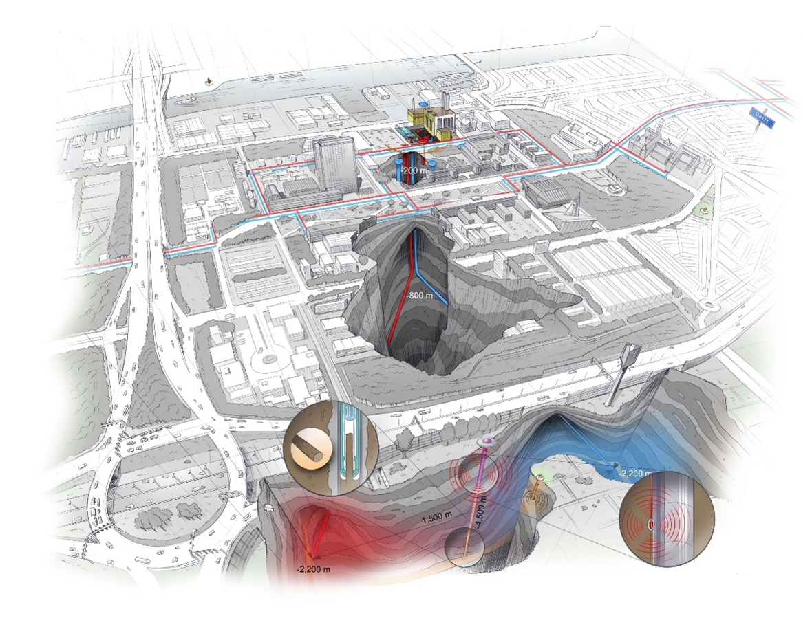
Figure 1Illustration of the Delft Subsurface Urban Energy Lab, including the gas-fired power plant; the geothermal wells; the heating grid; the HT-ATES; and, in the front, the deep monitoring borehole between the producer and injector (illustration credit: Studio Stephan Timmers). The schematic overview depicts roughly 1.5 × 1.5 km.
The large amounts of existing downhole information and data in the area of the TU Delft campus make it an ideal spot for a large-scale subsurface research infrastructure such as the Delft Subsurface Urban Energy Laboratory (DSUEL). Detailed knowledge of the deep subsurface is a pre-requisite for an interpretation of subsurface observations and how they can be related to processes and changes occurring as a consequence of human interference, such as fluid extraction and injection, heat storage, and sealing of the surface. The more measurements and data we have, the more we can understand, and the more accurately we can simulate processes and recommend actions to optimize our use of subsurface resources and space. However, despite several boreholes and available geophysical data in the region, one of the largest handicaps in the development of subsurface models and projects is the geological uncertainty and the unpredictable effects of the heterogeneous subsurface, as also experienced during the drilling of the deep geothermal wells on campus (Vardon et al., 2024c). Geological uncertainty has an effect on operations, for example, on the lifetime and safety of geothermal energy production. This uncertainty about the subsurface structure and its characteristics translates to uncertainty in understanding the risks related to subsurface energy production, such as subsidence, induced seismicity, leakage, groundwater contamination, and costs. Better knowledge and/or understanding of the subsurface and better resolution of subsurface observations therefore provide the basis for better modelling of coupled fluid flow, porosity evolution, dissolution–precipitation, chemical reactions, fracturing, reactivation of fractures, and fracture healing under natural conditions. Better knowledge of the subsurface requires more and better data. Data are required downhole and on the surface and over long periods of time during the operational life of the production site. With surface monitoring and current technologies, however, processes occurring at depth and gradual changes in time due to human operations can often not be resolved. For example, changes in resistivity caused by cooling due cold-water injection in a deep geothermal cycle are impossible to detect from the surface. Only with the development of novel geophysical monitoring technologies can the existing uncertainties of the subsurface be reduced. The proposed deep borehole offers the possibility to test advanced monitoring techniques in an operating geothermal system in order to allow long-term observation of the interference of human intervention and natural processes due to the use of the subsurface space and resources.
Densely populated urban areas pose an additional challenge as they usually present geophysical “noisy” environments, adding to the complexity of subsurface heterogeneity for data interpretation. The definition of the methods, approaches, and technologies to address all of these challenges was one of the central objectives of the ICDP UrbEnLab workshop.
All geological formations from the surface down to the Carboniferous Limburg Group are potential investigation targets for the planned multi-use exploration and monitoring borehole (Fig. 2). Each depth interval offers opportunities to address specific engineering and scientific questions, including groundwater flow, microbial activity, paleoclimate and paleoenvironmental studies, geomechanical behaviour of rocks and faults, heat and gas storage (e.g. CO2), and geothermal system analysis. The exact drill location is constrained by the positions of the DEL-GT-01 production well and the DEL-GT-02 injection well of the geothermal doublet on the TU Delft campus. The deep borehole will serve as a monitoring point for the geothermal operations and thus targets the reservoir zone between the two wells in the Schieland Group (Fig. 3) at a depth of around 2.2 km. Due to the deviation of the geothermal wells, the vertical multi-use borehole is projected several hundred metres away from the surface location of the geothermal doublet. A borehole location at the TU Delft campus will provide easier access to the land and associated facilities (e.g. electricity supply).
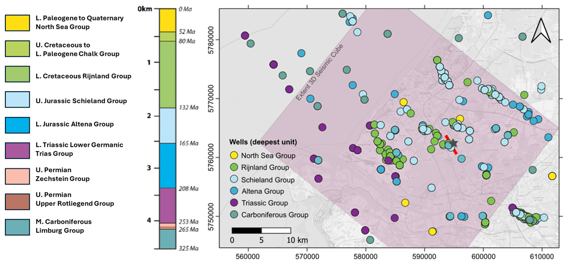
Figure 2Map of study area in the western Netherlands with geographical coordinates. Circles are boreholes from https://www.nlog.nl/ (last access: 8 December 2025), with the colour code representing the targeted and/or deepest lithological units; the pink-shaded box shows the extent of the 3D seismic cube released on https://www.nlog.nl/ in 2025. The potential drilling location of the deep borehole is the star, and the red line is the seismic section in Fig. 3.
The shallow formations in the borehole are expected to consist of variable sediments of the Cenozoic North Sea Group and the upper Cretaceous and lower Paleogene carbonate Chalk formation (Fig. 3). The Upper North Sea Group is of Miocene to Holocene age and consists of shallow marine to terrestrial sediments of fluvial, paralic, and lacustrine environments. This includes sandstones; occasional gravels; and finer-grained deposits, including clays and peat. Unconformities exist at the base and top of the Middle North Sea Group, but, also, intermittent intervals of non-deposition and erosion have occurred. The Lower North Sea Group is of Paleocene and lower Eocene age and consists of predominantly marine deposits and may include the Paleocene–Eocene transitional interval that is known by the Paleocene–Eocene Thermal Maximum (PETM) global warming episode (McInerney and Wing, 2011). The upper Cretaceous to Danian Chalk groups consist of fine-grained bioclastic marly limestones with intercalated horizontally oriented chert concretions (Hakanson et al., 1975).
Below, a series of formations occur that include prime geothermal energy plays in the WNB (Mijnlieff, 2020). These include the coastal to open marine Rijnland Group, displaying argillaceous deposits with occasional sandy and glauconitic intervals. The underlying Upper Jurassic to Lower Cretaceous Schieland Group includes the reservoir sand (Delft Sandstone) of multiple geothermal doublets, including the doublet installed at TU Delft campus. The Schieland Group consists of continental to shallow marine claystones, fluvial sandstones with intermittent coals, and floodplain soils. Gradual deepening to the Rijnland Group occurs with dominant relative sea-level fluctuations controlling alternating sequences of terrestrial and shallow marine deposits (Den Hartog Jager, 1996).
The Jurassic Altena Group expected at depths of approximately ∼2800–3400 m consists of open marine fine-grained mudstones with occasional coarser-grained sediments, highlighted by the prominent Posidonian shale (Fig. 3). The Altena unconformably overlies the fully terrestrial Lower Triassic Germanic Trias Group that consists of mudflat red beds with intercalating lacustrine and distal alluvial fan deposits and occasional basal fluvial systems (Geluk and Röhling, 1997). The Lower Triassic is seen as a major potential geothermal play in the Netherlands and beyond, although diagenetic cementation has significantly reduced porosity and permeability, such as in the nearby NLW-GT-01 well (Maniar, 2019; Boersma et al., 2021). The Permian is represented by the Zechstein and Upper Rotliegend groups that are also fully continental in nature. The Zechstein consists of evaporites and carbonates deposited in lakes, as well as intercalating dry mudflat clays and silts. The Upper Rotliegend deposits are playa lake deposits with aeolian intervals. These Permian deposits are expected to be rather thin to nearly absent. The lowest formation is the middle Carboniferous Limburg Group that is expected at depths of approximately ∼4000–5200 m, representing other possible geothermal targets. The Limburg Group consists of deltaic to fluvial plain clastics and intercalating coal beds. The series is well known for its dominant control by glacio-eustatic sea-level changes resulting in different orders of sedimentary sequences, including the coal-bearing cyclothems (e.g. Baars et al., 2023). It is expected that the drilling to 4.5 km will reach the Westphalian D Strijen Formation that consists of sandy mudstones deposited on distal fluvial plains with occasional sandstones.
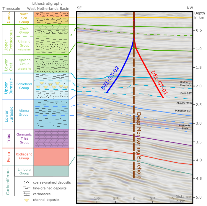
Figure 3Example seismic line and expected stratigraphy at the proposed drill site (indicated by a star and red line in Fig. 2) derived from the 3D seismic cube, showing sub-horizontal accumulation of strata from the Carboniferous to the Cenozoic in the WNB.
Several deep wells have been drilled in the region – on the structural highs for production of oil and, more recently, on the structural lows for geothermal purposes (Fig. 2). Within a radius of 5 km from the campus, a total of 36 wells or sidetracks are located to a maximum depth of about 2500 m. The information is mostly publicly available from the Netherlands Oil and Gas Portal website (https://www.nlog.nl/, last access: 8 December 2025). The Pijnacker hydrocarbon and geothermal wells (PNA-01 to 15 and PNA-GT-01 to 06); the Delft hydrocarbon DEL-01 to 08; and the new geothermal wells DEL-GT-01 and DEL-GT-02, 02-S1, and 02-S2 (Vardon et al., 2024c) are the closest offset wells for the deep monitoring borehole. Around 10 km to the west, the Naaldwijk well NLW-GT-01 extends to a vertical depth of 4013 m into the Lower Germanic Trias Group (not shown in Fig. 3).
In the DEL-GT-01, 02, 02-S1, and 02-S2 wells and sidetracks, a detailed open-hole logging campaign took place in the geothermal reservoir section straddling the uppermost Alblasserdam Claystone, the Delft Sandstone, and the lowermost Rodenrijs Claystone members, all part of the Nieuwerkerk Formation. A total of 86.5 m of 4 in. cores was retrieved from the lowermost Rodenrijs Claystone and upper Delft Sandstone members at a 55 °angle with respect to bedding plane (Vardon et al., 2024c). In the MON-GT-02 well, 60 m of 4 in. core was retrieved covering the Rijswijk Sandstone and upper Rodenrijs Claystone members. In DEL-GT-02-S2, 78 sidewall cores were obtained from the upper Alblasserdam Claystone and whole Delft Sandstone members.
The 3 d UrbEnLab workshop was held in Delft, the Netherlands, on 18 to 20 June 2024. It was attended by 75 participants from 17 countries affiliated with universities, research institutes, government agencies, and companies.
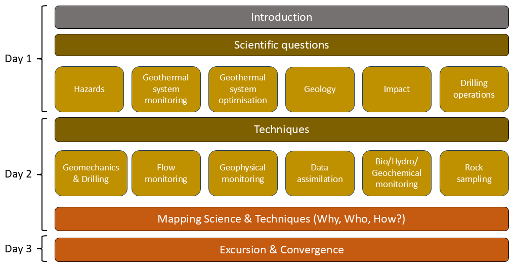
Figure 4Structure of the 3 d UrbEnLab workshop in Delft focussing on scientific questions and techniques for the deep exploration and monitoring borehole.
The workshop started with a welcome from the organizers and ICDP followed by an introduction providing the necessary background information on the project, with the main focus being on the geological setting. The afternoons of the first day and the second day were dedicated to a series of breakout and plenary sessions. The ambition was to actively engage as many participants as possible through small breakout groups (max. 20 people) and short plenary summaries.
The breakout sessions of day 1 focused on scientific questions to be addressed regarding the deep borehole. Six groups were set up with the following focus: hazards, geothermal system monitoring, geothermal system optimization, geology, impact, and drilling operations (Fig. 4).
On day 2, the breakout sessions were organized around techniques and included the following topics: geomechanics and drilling, flow monitoring, geophysical monitoring, data assimilation, biogeochemical and hydrogeochemical monitoring, and rock sampling. Day 2 was closed with a breakout session that focused on connecting the scientific questions with techniques. Divided into six groups, the participants discussed scientific priorities (why?), stakeholders (who?), techniques and design (how?), and risks.
Day 3 started with an excursion to the Rijswijk Centre for Sustainable Geo-energy (https://www.rcsg.nl/, last access: 15 July 2025). At the same time, the PIs/CoPIs and session chairs came together for a convergence session. During this session, the team was asked to prioritize and identify the five key scientific questions that should be addressed with the deep borehole. Also, the most important techniques and methods to collect the necessary data were discussed.
The UrbEnLab workshop was closed with a plenary session in which the core team presented the outcomes of the morning's convergence exercise (Fig. 4). The participants were asked for feedback, and the main scientific research questions and related techniques were refined accordingly.
In the following sections, the results of the different breakout sessions are summarized.
4.1 Scientific questions
4.1.1 Hazards and potential risks
As the request for subsurface space increases, several hazards arise, from the potentially competing utilization to several different purposes, especially in densely populated areas. Therefore, multi-subsurface usage requires a close collaboration between researchers, developers, municipalities, and local authorities. Interdisciplinary research on these interfering aspects is still missing. For geothermal systems such as the one in Delft, induced seismicity is a potential hazard, even though there has not been any known induced seismic event in the extensively exploited sandstone reservoirs of the West Netherlands Basin. There are still unknowns related to the local stress field and the mechanical properties of rocks and/or faults, as well as the possible propagation of the seismic wave. Another hazard relevant for geothermal systems (shallow and deep) is the integrity of the wellbore and the caprock, preventing contamination of surrounding rocks and aquifers. In addition, fluid chemistry and microbiological activity in the well and pipes, as well as in the reservoir and/or aquifer, can seriously affect geothermal operations due to corrosion, scaling, and clogging.
These aspects were discussed in the session, specifically addressing the role of the full research infrastructure on the Delft campus, including the deep borehole, the geothermal doublet, and the heat storage system.
The identified hazards and related research questions were as follows: how can competing subsurface usage best be coordinated and organized? Is induced seismicity controllable – and does it depend on whether it is pressure or cooling induced? Why do we observe induced seismicity for certain reservoir types and not for others? How can well integrity problems be mitigated? What are the risks of contamination? How are we dealing with the presence and co-production of natural gas? What are the optimal procedures to address effects caused by chemical reactions and microbiological activity? What factors influence social acceptance and how can they be addressed in public geothermal projects?
4.1.2 Geothermal system monitoring
Monitoring of geothermal systems is, to a large extent, done at the surface and with minimal effort due to budgetary constraints of the sector. Thus, the fundamental questions underlying the discussion were as follows: what monitoring techniques and approaches are available and what can be observed using them? What are the limitations of the techniques and what observations would be desirable but are not possible currently?
To address these questions, it is essential to establish a comprehensive set of in situ monitoring parameters once geothermal wells are drilled. These include temperature (T) at critical positions; mass flow rates (m); wellhead water level or pressure (P); chemical concentrations (C); and, where feasible, local seepage velocity (V), induced seismicity, and electric resistivity fields. Many of these parameters – particularly temperature, pressure, and concentration – can be continuously monitored using affordable, durable probes installed in observation wells. These enable the dynamic detection of cold and chemical fronts and support the calibration of surface measurements. The basic problem with all subsurface processes is that they can only be indirectly observed and measured from the surface. In addition, densely populated areas usually provide a lot of background noise for geophysical measurements, making the detection and distinction of subsurface signals challenging. A key aspect of a monitoring borehole is therefore the direct observation at depth (if technically possible) and the calibration of surface measurements, thereby enhancing data accuracy and bridging the gap between surface observations and subsurface dynamics.
The related scientific questions discussed in the session were as follows: is it possible to detect the propagation of the cold front between geothermal wells? And, if yes, what methods are needed and what conditions need to be met to observe it? How does the current stress field change due to operations and how does it influence operations? What is the likelihood of felt seismicity due to cold-water injection and operations in general? What is the effect of geothermal operations on the reservoir itself in the close and far field and at the regional scale? Is there an interference with neighbouring projects? What are the long-term effects of geothermal operations and how can social, economic, and technical consequences be anticipated and mitigated? How can the public be involved in the monitoring framework? Are there deeper geothermal reservoirs below the currently exploited system?
4.1.3 Geothermal system optimization
A research infrastructure as developed on the campus in Delft offers the possibility not only to measure and observe but also to optimize and improve subsurface exploitation in a sustainable manner. This includes optimized equipment lifetime, injection strategies, and field development concepts including multiple well bores, as well as integration of the heat storage system to buffer seasonal demand fluctuations.
In the session, the discussion was focussed on the general question of how the observations we make can be used to optimize operations. In this context, several questions were discussed: how can operations be adjusted in relation to the propagation of the cold front? What data need to be acquired based on the results of flow models? How can uncertainties in subsurface models best be quantified and reduced? What are the best long-term exploitation strategies for the entire field, including multiple wells (both vertical and horizontal)? How can these strategies be implemented within the existing regulatory framework (e.g. with respect to well spacing and injection temperature)? In what ways can chemical treatments be optimized, minimizing negative side effects? How can we determine the most suitable geothermal utilization model for urban areas in different geological settings?
4.1.4 Geology
The combination of operating shallow and deep geothermal wells with a deep observation borehole for exploration and monitoring provides a unique opportunity to reconstruct the geological history of the region and to relate it to both subsurface properties and engineering applications. To achieve this, detailed rock and fluid sampling, along with high-resolution well logging, is essential for characterizing the processes that led to reservoir formation.
The exploration and monitoring borehole targets two main geological intervals: the shallow aquifers and aquitards located between 100 and 300 m depth, which are relevant for high-temperature aquifer thermal energy storage (HT-ATES), and the deep geothermal reservoir hosted in the upper Nieuwerkerk Formation at depths of approximately 1.8 to 2.2 km. In addition to these, several other formations such as the Cretaceous Ommelanden and lower Nieuwerkerk formations, as well as the Triassic, Permian, and Carboniferous sandstones, present further potential for geothermal utilization or the extraction of critical raw materials.
Numerous research questions arise from the investigation of these targets. These include assessing the quality of the caprock for the HT-ATES system, describing and quantifying reservoir heterogeneity, determining the physical and chemical characteristics of the deep geothermal targets, and understanding the fracture networks and their contribution to fluid flow. Other key questions relate to the in situ stress field and its role in fault reactivation, as well as the evolution of geomechanical and thermal properties with increasing depth, pressure, and temperature and varying fluid chemistries. A further area of interest relates to how biogeochemical processes vary with geological setting and how they may influence subsurface operations. Addressing these questions will require integrated monitoring and sampling strategies, with some data needs overlapping between engineering and geological objectives.
In addition to reservoir-focused research, the deep borehole offers a unique opportunity to investigate several key intervals in Earth's climatic and environmental history. The early Quaternary period, which marks the onset of extensive Northern Hemisphere glaciation, is a critical interval for studying glacial–interglacial cycles, particularly in light of current global warming. The Middle to Late Miocene transition, associated with the initiation of North Atlantic Deep Water formation, offers insights into the evolution of ocean circulation and its climatic effects. The Paleocene–Eocene Thermal Maximum (PETM), a globally recognized greenhouse warming event, is likely to be preserved in the borehole as a 10 to 20 m thick interval, based on nearby well data, and is essential for understanding the rates and consequences of rapid climate change. The Triassic–Jurassic boundary, another globally significant perturbation, is represented in the region by anoxic or dysoxic marine sediments, and the preservation of organic-rich material could provide valuable insights into the dynamics of this transition.
Beyond paleoclimate and paleoenvironmental research, the borehole also addresses paleotectonic objectives. Reconstructing the burial history of the region enables the assessment of past temperature and pressure regimes and their effects on rock mechanics and fluid behaviour. One particular area of interest is the suite of structures related to the Variscan orogeny, including the prominent unconformity between the Carboniferous and Permian formations, known locally as the combined Base Permian and Saalian Unconformity. Although the fully developed Kupferschiefer horizon (a geochemical trap by accumulating metals) is not expected at this site, investigating its lateral equivalents as sedimentary or diagenetic markers could yield important information regarding their origin, distribution, and potential for critical raw material extraction.
Together, these multiple scientific targets make the observation borehole a cornerstone of multidisciplinary research into subsurface processes, bridging geothermal engineering, sedimentary geology, climate science, and resource exploration.
4.1.5 Societal impact
In this session the societal impact the research infrastructure can have and maybe already has at various levels was discussed. In general, it was concluded that there is a need to look at short-, medium-, and long-term impacts as the temporal and spatial resolution of impacts can vary.
Regarding the societal impact, it was highlighted that the monitoring infrastructure including the deep borehole and the DSUEL in general provide a great opportunity to engage local communities through outreach activities. Having a demonstration site on a university campus for people to visit has the potential to change mindsets related to energy production in an urban environment. This has also been observed during drilling of the TU Delft campus geothermal wells, where more than 1000 people came to visit and learn more about the project. Engagement of municipalities and local regulators can also provide the needed impact on a policy and governance level. In addition, an energy infrastructure that is accessible and has all data and information available to the public can serve as an excellent showcase for education. Both school classes and student groups can visit the test site at all stages of development, and TU Delft scientists can visit schools to talk about geothermal energy and subsurface processes, the questions we have, and the methods we use to answer them. The site with the deep borehole can be used as a place for students from other universities engaging in geothermal research and teaching to visit and, as such, can have an impact well beyond regional and national borders. It is an ideal location for cooperation with international research teams who would like to learn about all aspects of geothermal developments.
The research infrastructure will create further impacts through the development of new knowledge and the opportunity for researchers and others to work across and with multiple disciplines (e.g. engineers, energy system designers, social science, economists, behavioural science). On a scientific level, such a unique system can help address fundamental questions about, for example, reservoir and/or geological responses and reservoir optimization, but it also supports technical developments by testing innovative tools or monitoring systems (as part of a living-lab approach,) which can result in new intellectual property. The infrastructure can act as an example project with respect to data handling and transparency, setting up databases on various datasets and AI applications in relation to those. In particular, long-term data on the operating system will give the opportunity to create impact with respect to regulations and policies.
At an international level, the DSUEL can function as a hub to attract and collaborate with international partners and experts with complementary skills. This can help to fill knowledge gaps and gives the opportunity to liaise with similar projects and/or observatories (Cornell, FORGE, UKGEOS, Bedretto, GeoLaB). It can also act as example or inspiration for projects that are not developed yet (Leeds, Dublin).
An expensive and large research infrastructure does not guarantee impact in science and society, and so the key questions are as follows: how can the impact be guaranteed, monitored, and optimized? What are the key parameters to be monitored for public acceptance, for regulations, and for economic success and sustainable operations?
In addition to the questions raised and discussed in the session on the societal impact of such a deep research borehole, questions on public acceptance and stakeholder engagement came up as a recurring issue in several working groups. In particular, hazards and potential risks resulting from geothermal operations in general and on the TU Delft campus and the drilling of the deep borehole in particular were discussed in terms of their impact on stakeholder engagement and public concerns. In the context of hazards and risk, the following general question came up: what factors influence social acceptance and how can they be addressed in public geothermal projects? Specific public concerns are potential seismicity and pollution of drinking water due to drilling or geothermal operations. A seismic event due to cold-water injection might have considerable impact on the local community and the operation of the infrastructure itself. These risks need to be clearly and openly communicated. The monitoring infrastructure provides an ideal opportunity to transparently and openly measure and communicate what can be observed. This communication aspect therefore has to be an integral component in the planning of the monitoring programmes, including the question of interference between geothermal operations with neighbouring geothermal fields and with other subsurface operations and infrastructures.
Thus, two major questions raised in connection with monitoring were as follows: what are the long-term effects of geothermal operations and how can social, economic, and technical consequences be anticipated and mitigated? How can the public be involved in the monitoring framework?
4.2 Techniques
In part 2 of the workshop, techniques to address the geothermal research questions in general, including novel techniques to be developed, were discussed. These techniques will be used to investigate and monitor processes in the geothermal reservoir at 2 km depth but also to characterize and test potential reservoirs at greater depths.
4.2.1 Drilling operations and well design
The primary objective of the deep borehole is to address fundamental research questions. Downhole instrumentation and advanced tools utilized to assess the subsurface require innovative solutions in terms of operations and well design. The well design needs to integrate the planned use of monitoring equipment, including fibre optic cables, seismometers, and other types of sensors, to ensure optimal placement and reliable data acquisition. The use of advanced downhole tools for electromagnetic methods is limited to casing made of non-metallic materials, such as composite casing, to reduce interference with the monitoring tools and to enhance their performance. Casing materials are required to comply with certain standards within the regulatory framework to ensure long-term integrity and eventual safe abandonment. Assessment of borehole quality (tortuosity) and inclination while drilling should be aligned with the minimum requirements recommended to ensure sensor and casing installation. Formation fluid sampling from depth or intervals of interest requires dedicated zonal isolation techniques, which require corresponding well design solutions. Deep boreholes are associated with various challenges, including wellbore instability, hole cleaning, and geo-steering. Consequently, continuous monitoring and assessment of the drilling process using surface and downhole sensors with a drilling advisory system will assist in reducing non-productive time, ensuring safe operations, and reaching the target depth.
The key operational challenge is to identify the optimum well construction design, materials, and operations while integrating downhole sensor installations, formation evaluation, and fluid sampling. This involves an approach and technologies in which the drilling programme is designed to fulfil the technical requirements to address and achieve the scientific objectives of the deep borehole. Novel drilling technologies including intelligent packers, casing materials, and downhole measurements at or near the drill bit should be incorporated into an evaluation framework, which allows reliable assessment of field test results. Fostering emerging technologies such as downhole tools, machine learning, artificial intelligence, and drilling data analytics drives innovation with regard to real-time decision-making and cost-effective operations.
Data obtained during drilling operations can provide valuable insights into subsurface characteristics. This session covered various techniques to address scientific questions, including those relating to tracer tests, fluid sampling, and in situ stress determination.
4.2.2 Geomechanics and drilling
Even in geothermal reservoirs with good primary porosity, a key parameter to be investigated and monitored is the geomechanical stability of fractures and faults in and near the reservoir. For this reason, a detailed determination of the in situ stress field is required. This includes image and caliper logs in the open hole, potentially mini-frac tests in the open or cased hole and leak-off tests (LOTs) or extended LOTs (XLOTs). These tests are also relevant for flow monitoring along potential fracture networks.
4.2.3 Flow and pressure monitoring
As the borehole will be deeper than the geothermal wells, accessibility of the geothermal reservoir at roughly 2 km depth needs to be accommodated for flow and pressure (water level) monitoring. Flow monitoring may require both temporary and permanent installation of pressure gauge(s) at the relevant depth. In addition, tracer tests could provide valuable information about the flow in the reservoir.
4.2.4 Biochemical and hydrochemical monitoring
Access to the reservoirs is also important for fluid sampling and chemical or microbial analysis. Techniques to be developed or applied need to enable the determination of the fluid chemistry with an emphasis on critical raw materials such as lithium and on potential environmental impact. The influence of geothermal operations on microbial life at depth and vice versa is another important aspect to be investigated. Microbial monitoring can be carried out on fluid, as well as core samples.
4.2.5 Rock sampling
Numerous solid samples will be taken during the drilling process. This includes cuttings and cores from various depths and at various sizes, i.e. full size (4′′) cores and side wall cores. These samples, together with data from geophysical logs, will be used for geological characterization, geomechanical testing, and experiments on fluid–rock–interaction and to determine microbial activities in the relevant environments.
4.2.6 Geophysical monitoring
To address several of the scientific questions, geophysical monitoring is required. Understanding the reservoir response to long-term cooling is important for both safety and efficiency of operations. Hence, being able to follow the development of the cooling volume around the injection well is of utmost importance. Temperature in the borehole will be directly measured using a distributed temperature sensing (DTS) fibre optic cable. We plan to use a time lapse 3D surface of borehole geophysical surveys by measuring vertical seismic (VSP) and electromagnetic profiles over tens of years. For the seismic measurements, a fibre optic cable will be installed for distributed acoustic sensing (DAS) and distributed strain sensing (DSS), and ambient noise or active sources can be used. For the electromagnetic measurements, only active electric dipole sources will be used. There is an option to include a pressure gauge for flow monitoring (as indicated above).
Preferential flow paths may exist because of heterogeneity in the reservoir, which may influence the operational life. Knowledge of the presence and extent of such paths is important for well planning. This can be done only when they can be mapped and understood from geological model building. The position of the reservoir in a geological model determines what can be expected in terms of spatial heterogeneity. Being able to reduce the number of plausible geological scenarios is important to improve the understanding of the reservoir response to long-term cooling and to forecast future response behaviour.
Such forecasting will be done by multi-physics data assimilation using temperature and pressure data in the geothermal wells and the deep borehole together with electric field data and seismic data measured in the deep borehole, with sources at multiple locations on the ground surface. In the last few years, a seismic monitoring network of seismometers in shallow boreholes has been established on and around the TU Delft campus. This will be complemented by temporary surface stations. Special emphasis will be placed on the development and installation of capacitive electrodes in composite casing along the borehole to monitor electrical resistivity in the reservoir and its change with time and cooling of the reservoir fluid (Eltayieb et al., 2023). First tests in shallow boreholes were successful (Drijkoningen et al., 2024), and now testing the setup in a 300 m deep borehole is planned. In case the deep borehole can remain open from the surface to the level where composite casing is used, several interesting logging options exist, such as density and/or gravity, electric resistivity, high-frequency electromagnetic, and magnetic susceptibility, which can be repeatedly done. This will allow us to determine important additional parameters and their evolution over time, which will improve our understanding and forecasting of reservoir responses.
4.2.7 Data assimilation
Deep borehole observations provide a diverse array of static and dynamic data from multiple sources. Static data – such as logs, cuttings, and core analyses – can be significantly enhanced through AI-driven methods for cleaning, processing, and interpretation. As a result, sophisticated AI tools will be developed and integrated into workflows spanning data acquisition, visualization, and management. Simultaneously, dynamic data will be automatically processed using advanced data assimilation methods, underpinned by forward modelling of fluid flow and energy transfer (Voskov et al., 2024). Unlike traditional reservoir simulations, geothermal modelling can incorporate geophysical observations – such as electromagnetic data – which can significantly enhance the outcome of data assimilation (Oudshoorn et al., 2024), i.e. improve the accuracy of the temperature forecast, and, therefore, the decision making. While AI plays a key role in data handling and assimilation, geothermal modelling remains indispensable for large-scale simulation and the evolution of geothermal reservoir characteristics from those monitored data. To ensure greater reliability, it is essential to establish well-defined guidelines and workflows focused on characterizing and reducing uncertainty. Traditional geological modelling and reservoir simulation approaches for uncertainty reduction (Chen et al., 2025) will be complemented by emerging techniques in geological modelling (e.g. Song et al., 2025), enabling a hybrid approach that integrates physics-based and data-driven models.
Another challenge lies in the large geometric scale disparity between the wellbore and the surrounding formation, which makes coupling of processes across the interface between the wellbore and the reservoir difficult. In general, further development is needed to improve the robustness, stability, usability, and computational efficiency of numerical simulators. This includes the development of advanced numerical methods for multiphase fluid flow, treatment of heterogeneity in porous and fractured media, and mathematical schemes for interface coupling.
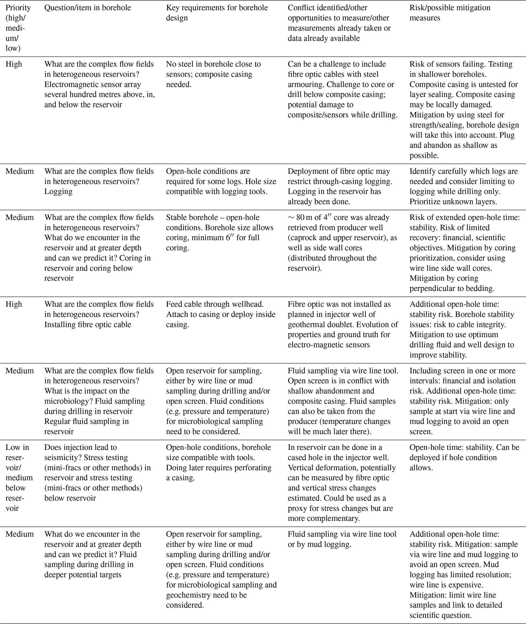
Deep drilling projects are, by nature, complex and challenging and hold risk. Moreover, only one deep borehole will be drilled for exploration and monitoring, and including all aspects in the well design and drilling programme has its challenges given the limited space and the different requirements of the various technologies. Therefore, prioritization is a key element of planning and well design, with mitigation strategies being included from the initial design criteria. Furthermore, at the heart of the Delft Subsurface Urban Energy Lab is a geothermal doublet (drilling completed late 2023) that is due to come into operation in early 2026. It was thus a key aspect of the workshop to link scientific questions to available and new techniques and to prioritize this, keeping in mind the other opportunities for measurements and monitoring available in the DSUEL, such that the priorities for this borehole are defined for aspects that cannot be covered in other ways.
It was the overall consensus in the international community, represented by the workshop participants, that the key scientific questions should focus on the life cycle of a natural and exploited geothermal system. The tasks and activities identified as contributing to each scientific question (and the sub-questions identified in Fig. 5) are presented in Table 1, alongside an initial scoping exercise regarding the priorities, the key borehole requirements to enable them, conflicts or availability of data from different sources, and risks and mitigation measures. These aspects will provide input for the borehole design and planning of operations.
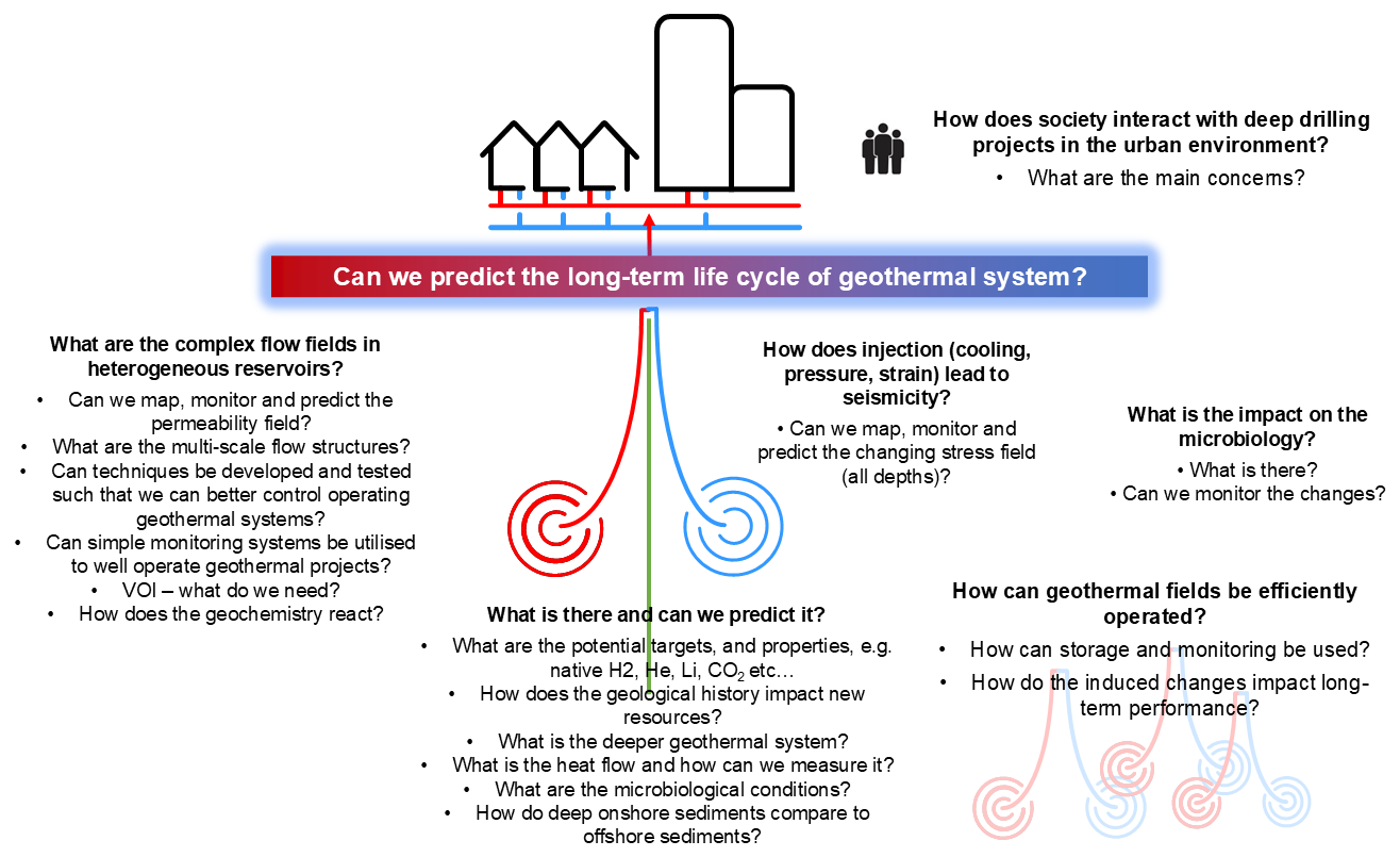
Table 1Overview of the identified tasks and activities in the borehole, including an initial prioritization and overview of borehole requirements to accommodate them.
A deep observation and monitoring borehole on the TU Delft campus is fully in line with the Strategic Research and Innovation Agenda (SRIA) of the European Technology and Innovation Platform on Geothermal published in 2023 (ETIP-G, 2023) and with the vision for 2050 of the Implementing Working Group of the SET Plan. In the IEA report on The Future of Geothermal Energy (2024), the need for downhole research infrastructure for testing and observation is mentioned explicitly. The SRIA identified four major areas for research and innovation; each one is prominently addressed by the infrastructure established for the Delft Subsurface Urban Energy Lab with the deep exploration, observation, and/or monitoring borehole on the TU Delft campus:
-
Resource assessment strategies, reducing the uncertainty around uncertainties related to exploration, and the identification of latent geothermal resources at all depths and the need to refine predictive technologies are areas of particular concern.
-
Drilling innovations and cost-efficient methodologies, in particular, novel approaches and materials in well construction, are needed.
-
Optimal resource utilization, maximizing the efficiency of resource use and system integration, including the potential extraction of valuable minerals, is needed.
-
Sustainable practices, both economic and environmental, are necessary.
Resource assessment, as defined in the SRIA, is performed to minimize the risks associated with pre-drill mining, to extend the scope of available resources, and to refine methods for identifying untapped potential. The major focus is on reducing uncertainty about subsurface flow via understanding better the subsurface and reservoir properties. With the drilling and installation of the deep borehole, the UrbEnLab project addresses this research priority directly as geothermal reservoir data from an operating sedimentary geothermal environment will become available in unprecedented detail and resolution. This will enable performance assessment and the incorporation of advanced conceptual models and characterization techniques. The information gathered in this well-characterized operating geothermal system is also of great transferrable value for other sites in urban areas. In addition, by targeting much deeper stratigraphic units than the currently exploited geothermal reservoir of the Delft Sandstone, generic exploration of potential geothermal targets with highly uncertain properties is performed. The deep borehole observations are complemented by multiple observations and measurements at the surface, which will help to greatly improve calibration of surface exploration tools and methods with the detailed downhole data and the production data from the producing geothermal wells.
Innovative concepts for drilling and subsurface engineering, including the use of novel completion materials and techniques, are at the core of the drilling project as the borehole will be designed to allow as many different monitoring techniques as possible in one hole. Beyond the installation of a fibre optic cable, new instruments requiring non-metallic casing will be accommodated, as well as multiple different sensors. Access to the reservoir for testing is a requirement that needs to be combined with the geophysical monitoring, such that drilling and completion are faced with multiple challenges to be addressed with innovative and novel solutions.
Optimal resource utilization and system integration are central to the geothermal developments on the TU Delft campus, combining deep geothermal wells with high-temperature underground energy storage in shallow and deeper aquifers. Thus, efficient conversion of geothermal resources into usable energy is coupled with effective heat storage. While the potential of co-production of critical raw materials is not given for the currently exploited geothermal reservoir, the deeper targets of the observation borehole will be investigated for promising mineral compositions, enhancing the economic viability of a geothermal development. Overall, there is no other research facility in the world collecting such a wide range of data and allowing continuous monitoring and measurements in an operating geothermal system, available for the analysis and improvement of operational efficiency.
Given the dense urban setting, the environmental impact of geothermal operations needs to be closely monitored and minimized. In addition, the manifold utilization of the shallow and deep subsurface holds the potential for interference. The dense monitoring system, the continuous monitoring planned with the addition of the deep borehole, and the multiple novel monitoring tools will provide the best possible setting to control and optimize safe and sustainable resource management. In addition to technical performance challenges, protection of the environment throughout the life cycle of geothermal operations and public perceptions of environmental impacts can be addressed in the public setting of the university campus.
In addition to the SRIA, several roadmaps and vision documents emphasize the need for upscaling geothermal field developments to accelerate the energy transition and to lower the cost of geothermal energy. In a so-called portfolio approach, an exploration borehole as the first in a series of other deep wells is seen as a key factor in bringing down the exploration risk for an entire area that is developed systematically. The development of portfolio methodology and tooling frameworks for applications in different geological settings requires a calibration network, which could well be developed around the deep borehole and the DSUEL. Two operating geothermal doublets already exist nearby, producing from the same reservoir as the TU Delft campus geothermal project. In addition, several hydrocarbon exploration and production wells exist in the area, targeting the same reservoir, thus providing a core portfolio for the calibration of a systematic development of relevance for geothermal heating and cooling.
In the ICDP document on support for geothermal drilling projects, the key research question on geo-resources “how can we improve our understanding of and gain access to low-carbon energy sources, particularly for geothermal energy?” is closely related to the first research area defined in the SRIA.
The ICDP geothermal strategy defines three research fields: (1) supercritical and ultra-high temperature systems, (2) enhanced geothermal systems (EGSs), and (3) low- to mid-enthalpy geothermal systems. Research field 3 is clearly addressed by drilling the deep borehole on the TU Delft campus as a classic low- to mid-enthalpy system will be monitored. With the target at 4+ km depth, however, a potential EGS is accessed, relating to ICDP research field 2, and the relevant research questions connected with its development are addressed by the research plan discussed during the workshop: what are potential fluid pathways that need to be enhanced? What is the in situ stress at depth? What is the risk of fault reactivation and induced seismicity?
Out of the four components defined by the ICDP for the relevant research fields, the UrbEnLab project addresses three:
-
Monitoring is covered in the UrbEnLab research plan by the high-end, high-resolution monitoring programme.
-
Simulation is a key component of all research planned in order to investigate complex coupled processes and, eventually, to reduce uncertainty in subsurface developments. This is enabled by the high-quality information on rock and fluid characteristics and the broad range of data continuously collected and evaluated from the deep borehole and the monitoring network.
-
Technology challenges are addressed by the development and use of monitoring instrumentation for (long-term) operation at >100 °C under hostile conditions.
With the strong alignment of the research plan and the research demand defined by the strategic documents mentioned above, the UrbEnLab borehole project meets all the requirements for ICDP projects. It will be a key component of a unique and high-impact research infrastructure on the TU Delft campus, designed to address several core objectives essential for advancing Earth sciences and geothermal research. First, it enables world-class science by addressing fundamental questions that have remained unresolved in Earth sciences. These include complex issues related to subsurface fluid flow, geomechanical behaviour, thermal evolution, and interactions between human activities and geological systems. By collecting detailed and continuous data from a deep, instrumented borehole in an operational geothermal environment, researchers can explore these challenges with a level of resolution and continuity rarely achieved.
Second, the project provides a world-class site where critical geothermal science questions can be studied directly and under real operational conditions. The location in a densely populated urban area, with overlapping uses of the shallow and deep subsurface, makes it highly representative of many future geothermal development zones worldwide. This allows findings and methodologies developed at the Delft site to be transferred and adapted to similar projects elsewhere, enhancing the broader impact of the research.
Third, the project presents a world-class opportunity to understand processes of overarching importance, reaching far beyond a single local application. It offers a rare test bed to study the full life cycle of a geothermal system, including exploration, monitoring, production, and long-term sustainability. The knowledge gained will inform not only geothermal energy development but also broader topics such as climate change adaptation, urban energy planning, and responsible subsurface resource management.
The deep monitoring borehole will be one of the major components of the Delft Subsurface Urban Energy Laboratory and is part of the national research infrastructure EPOS-NL/EPOS eNLarge. In the upcoming years, the TU Delft team will work on the design of the borehole that matches the scope of available funding from the EPOS-eNLarge project. We also plan, however, to further broaden the scope using the input from the participants of the workshop. For this purpose, additional funding is needed. We also envision further strengthening the international collaboration that started during the UrbEnLab workshop in Delft by, for example, building a community of geothermal test beds. The Delft Subsurface Urban Energy Laboratory would form an essential part of such a community.
No data sets were used in this article.
DB, SL, and PJV developed and wrote the workshop proposal based on input and experience by PF and co-organized the workshop with AK. HA, CB, MB, RC, MD, PF, VH-M, EH, SJ, HL, and DV led breakout sessions as discussion leaders. DB, PJV, and ES coordinated the synthesis of the workshop results. HA, CB, MB, and TS wrote and contributed to the geological concept, while AB and LV-M proposed the sampling strategy, and GD, MD, JM, PR, and ES proposed the monitoring concept. AKB, SJ, and HL discussed the societal impact. RC, AD, and DV developed the advanced simulation concept. DB and SL co-wrote the paper with input from all of the co-authors.
The contact author has declared that none of the authors has any competing interests.
Publisher's note: Copernicus Publications remains neutral with regard to jurisdictional claims made in the text, published maps, institutional affiliations, or any other geographical representation in this paper. The authors bear the ultimate responsibility for providing appropriate place names. Views expressed in the text are those of the authors and do not necessarily reflect the views of the publisher.
The UrbEnLab workshop was funded by ICDP, and the borehole will be funded mainly by the EPOS-eNLarge project, which is funded by the Dutch Research Council (NWO; project no. 184.036.007).
This research has been supported by the Nederlandse Organisatie voor Wetenschappelijk Onderzoek (grant no. 184.036.007). Th workshop was supported by ICDP.
This paper was edited by Tomoaki Morishita and reviewed by Albert Genter and one anonymous referee.
Baars, T. F., Huis in `t Veld, R., Zhang, L., Koopmans, M., McLean, D., Martinius, A. W., and Abels, H. A.: A cyclostratigraphic framework of the upper Carboniferous Westoe and Cleaver formations in the southern North Sea Basin as a methodology for stratigraphic reservoir characterisation, Netherlands Journal of Geosciences, 102, https://doi.org/10.1017/njg.2023.8, 2023.
Bloemendal, M., Vardon, P. J., Pijnenborg, M., Sudintas, G., Medema, A., Marif, K., Beernink, S., van Veldhuizen, F., Snelleman, S., and van Oort, T.: A techno-economic evaluation of high temperature thermal aquifer storage (HT-ATES) for use with the geothermal well on the TU Delft campus, World Geothermal Congress, https://worldgeothermal.org/pdf/IGAstandard/WGC/2020/16013.pdf (last access: 9 February 2026), 2021.
Boersma, Q. D., Bruna, P. O., de Hoop, S., Vinci, F., Tehrani, A. M., and Bertotti, G.: The impact of natural fractures on heat extraction from tight Triassic sandstones in the West Netherlands Basin: a case study combining well, seismic and numerical data, Netherlands Journal of Geosciences, 100, https://doi.org/10.1017/njg.2020.21, 2021.
Chen, Y., Rongier, G., Mullins, J. R., Voskov, D., and Daniilidis, A.: Coupled Numerical and Analytical Simulation on Delft Campus Geothermal Well, 50th Stanford Workshop on Geothermal Reservoir Engineering, https://pangea.stanford.edu/ERE/db/GeoConf/papers/SGW/2025/Chen1.pdf (last access: 10 February, 2026), 2025.
Den Hartog Jager, D. G.: Fluviomarine sequences in the Lower Cretaceous of the West Netherlands Basin: correlation and seismic expression, in: Geology of gas and oil under the Netherlands: Dordrecht, edited by: Rondeel, H. E., Batjes, D. A. J., and Nieuwenhuijs, W. H., Kluwer Academic Publishers, 229–241 pp., https://doi.org/10.1007/978-94-009-0121-6_19, 1996.
Drijkoningen, G., Ravilov, M., Heller, K., and Van Beek, K.: Capacitively coupled EM sensors integrated in non-corrosive casings for long-term CSEM monitoring, 85th EAGE Annual Conference & Exhibition, edited by: Rondeel, H. E., https://doi.org/10.3997/2214-4609.2024101491, 2024.
Eltayieb, M., Werthmüller, D., Drijkoningen, G., and Slob, E.: Feasibility Study of Controlled-Source Electromagnetic Method for Monitoring Low-Enthalpy Geothermal Reservoirs, Applied Sciences, 13, 9399, H. E. Rondeel 2023.
ETIP-G: European Technology and Innovation Platform on Geothermal “Strategic research and innovation agenda”, 116 pp., ISBN 978-2-9601946-3-0, 2023.
Geluk, M. C. and Röhling H.-G.: High-resolution sequence stratigraphy of the Lower Triassic `Buntsandstein' in the Netherlands and northwestern Germany, Geol Mijnbouw, 76, 227–246, 1997.
Hakanson, E., Bromley, V., and Perch-Nielsen, K.: Maastrichtian Chalk of North-West Europe – a Pelagic Shelf Sediment, Chapter 9 in Pelagic Sediments: On land and under the Sea, edited by: Hsü, K. J. and Jenkyns, H. C., https://doi.org/10.1002/9781444304855.ch9, 1975.
IEA: The Future of Geothermal Energy, IEA Publications – International Energy Agency, 126 pp., https://www.iea.org/reports/the-future-of-geothermal-energy (last access: 10 February 2026), 2024.
Limberger, J., Boxem, T., Pluymaekers, M., Bruhn, D., Manzella, A., Calcagno, P., Beekman, F., Cloetingh, S., and van Wees, J.-D.: Geothermal energy in deep aquifers: A global assessment of the resource base for direct heat utilization, Renewable and Sustainable Energy Reviews, 82, 961–975, ISSN 1364-0321, https://doi.org/10.1016/j.rser.2017.09.084, 2018.
Maniar, Z.: Reservoir quality analysis of the Triassic sandstones in the Nederweert and Naaldwijk areas: a post-mortem study, Delft University of Technology, https://repository.tudelft.nl/islandora/object/uuid:f2f2427b-a056-4b5e-b9d7-76b076950955 (last access: 10 February 2026), 2019.
McInerney, F. A. and Wing, S. L.: The PETM: A perturbation of carbon cycle, climate, and biosphere with implications for the future, Ann. Rev. of Earth Plan. Sci., 39, 489–516, 2011.
Mijnlieff, H. F.: Introduction to the geothermal play and reservoir geology of the Netherlands, Netherlands Journal of Geosciences, 99, https://doi.org/10.1017/njg.2020.2, 2020.
Oudshoorn, C., Werthmüller, D., Slob, E., and Voskov, D.: Numerical experiment on data assimilation for geothermal doublets using production data and electromagnetic observations, Geophysics, 89, M227–M237, https://doi.org/10.1190/GEO2023-0463.1, 2024.
Song, G., Geiger, S., Voskov, D., Abels, H. A., and Vardon P. J.: Assessing the Ensemble Smoother with Multiple Data Assimilation for Subsurface Fluvial Geothermal Systems, 50th Stanford Workshop on Geothermal Reservoir Engineering, https://doi.org/10.22541/essoar.174835517.79259134/v1, 2025.
Vardon, P. J., Bruhn, D. F., Steiginga, A., Cox, B., Abels, H., Barnhoorn, A., Drijkoningen, G., Slob, E., and Wapenaar, K.: A Geothermal Well Doublet for Research and Heat Supply of the TU Delft Campus, World Geothermal Congress, https://arxiv.org/abs/2003.11826 (last access: 10 February 2025), 2020.
Vardon, P. J., Abels, H., Barnhoorn, A., Daniilidis, A., Bruhn, D., Drijkoningen, G., Elliott, K., van Esser, B., Laumann, S., van Paassen, P., Vargas Meleza, L., Vondrak, A., and Voskov, D.: A research and energy production geothermal project on the TU Delft campus: Project implementation and initial data collection, Proceedings of the 49th Stanford Workshop on Geothermal Reservoir Engineering, https://pangea.stanford.edu/ERE/db/GeoConf/papers/SGW/2024/Vardon.pdf (last access: 10 February 2026), 2024a.
Vardon, P. J., Abels, H., Barnhoorn, A., Daniilidis, A., Drijkoningen, G., Laumann, S., Vargas Meleza, L., and Voskov, D.: Geothermal Project on TU Delft Campus Collection, Version 6, 4TU.ResearchData. collection, https://doi.org/10.4121/85b3725b-80fa-4b0b-9db2-475bfd8f0265.v6, 2024b.
Vardon, P. J., Laumann, S. J., van Esser, B. T. M., Ursem, L. J. H., van Schravendijk, B., Vargas Meleza, L., Barnhoorn, A., Abels, H. A., Vondrak, A. G., Drijkoningen, G. G., van Paassen, P. A. M., Elliott, K. N., van den Berg, J. J., and Friebel, M.: End-of-Well Science Programme Report DEL-GT-01 and DEL-GT-02, TU Delft campus geothermal project, Delft University of Technology, https://resolver.tudelft.nl/uuid:6ce07471-6986-434e-aa24-ad6e1f6714d9 (last access: 10 February 2026), 2024c.
Voskov, D., Abels, H., Barnhoorn, A., Chen, Y., Daniilidis, A., Bruhn, D., Drijkoningen, G., Geiger, S. Laumann, S., Song, G., Vardon, P., Vargas Meleza, L., Verschuur, E., and Vondrak, A.: A research and production geothermal project on the TU Delft campus: initial modeling and establishment of a digital twin, 49th Stanford Workshop on Geothermal Reservoir Engineering, https://pangea.stanford.edu/ERE/db/GeoConf/papers/SGW/2024/Voskov.pdf (last access: 10 February 2026), 2024.