the Creative Commons Attribution 4.0 License.
the Creative Commons Attribution 4.0 License.
 | 18 Jun 2024
BASE (Barberton Archean Surface Environments) – drilling Paleoarchean coastal strata of the Barberton Greenstone Belt
Christoph Heubeck
Nic Beukes
Michiel de Kock
Martin Homann
Emmanuelle J. Javaux
Takeshi Kakegawa
Stefan Lalonde
Paul Mason
Phumelele Mashele
Dora Paprika
Chris Rippon
Mike Tice
Rodney Tucker
Ryan Tucker
Victor Ndazamo
Astrid Christianson
Cindy Kunkel
The BASE (Barberton Archean Surface Environments) scientific drilling project aimed at recovering an unweathered continuous core from the Paleoarchean Moodies Group (ca. 3.2 Ga), central Barberton Greenstone Belt (BGB), South Africa. These strata comprise some of the oldest well-preserved sedimentary strata on Earth, deposited within only a few million years in alluvial, fluvial, coastal-deltaic, tidal, and prodeltaic settings. They represent a very-high-resolution record of Paleoarchean surface conditions and processes. Moodies Group strata consist of polymict conglomerates, widespread quartzose, lithic and arkosic sandstones, siltstones, shales, and rare banded-iron formations (BIFs) and jaspilites, interbedded with tuffs and several thin lavas. This report describes objectives, drilling, and data sets; it supplements the operational report.
Eight inclined boreholes between 280 and 495 m length, drilled from November 2021 through July 2022, obtained a total of 2903 m of curated core of variable quality through steeply to subvertically dipping, in part overturned stratigraphic sections. All drilling objectives were reached. Boreholes encountered a variety of conglomerates, diverse and abundant, mostly tuffaceous sandstones, rhythmically laminated shale-siltstone and banded-iron formations, and several horizons of early-diagenetic silicified sulfate concretions. Oxidative weathering reached far deeper than expected. Fracturing was more intense, and BIFs and jaspilites were thicker than anticipated. Two ca. 1 km long mine adits and a water tunnel, traversing four thick stratigraphic sections within the upper Moodies Group in the central BGB, were also sampled. All boreholes were logged by downhole wireline geophysical instruments. The core was processed (oriented, slabbed, photographed, described, and archived) in a large, publicly accessible hall in downtown Barberton. A geological exhibition provided background explanations for visitors and related the drilling objectives to the recently established Barberton Makhonjwa Mountains World Heritage Site. A substantial education, outreach, and publicity program addressed the information needs of the local population and of local and regional stakeholders.
- Article
(38502 KB) - Full-text XML
- BibTeX
- EndNote


1.1 The Archean
The Archean eon encompasses the fundamental events of building a habitable planet, evident from comparing the state of Earth at the beginning of that eon at 4 Ga and 1500 million years later. However, we know little about this critical time period, such as the temperature and composition of the oceans and the atmosphere, continental freeboard, nature of the geomagnetic field, consequences of a high spin rate and intense solar UV radiation, volcanism, meteorite impacts, tides, and the role shorelines played as biological laboratories for early life, to name a few (Fig. 1). This is due to a scarce rock record, considerable degree of deformation and metamorphism, and poor exposure of existing strata. The few Paleoarchean marine–terrestrial transitional strata preserve a unique and potentially valuable record which allows us to constrain the history of interaction between the geosphere, biosphere, and atmosphere. This includes conditions of paleosol formation, intensity, and type of weathering and processes of sediment generation and maturation. The oldest preserved (microbial) traces of early life on land have a bearing on fundamental geosphere–biosphere interactions such as the mechanism and degree of nutrient delivery, strategies of radiation avoidance, and atmospheric composition. Eolian strata may convey unique environmental parameters such as local wind strength and atmospheric density, with implications for aridity and circulatory systems. Lastly, terrestrial evaporites relate to temperature, evaporation, and groundwater movement.
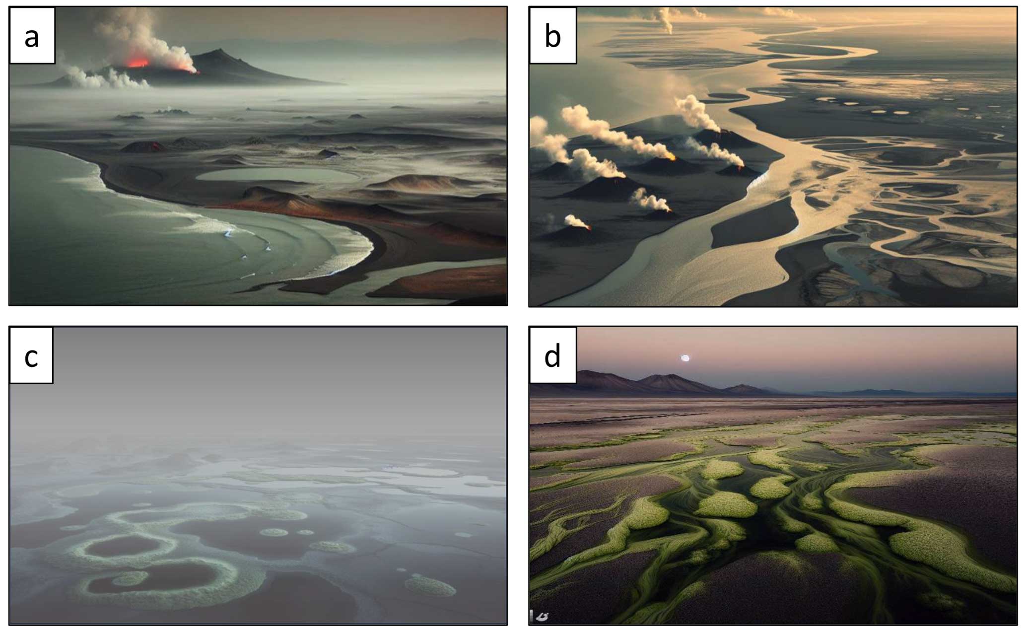
Figure 1AI-generated visualizations (Image Creator from © Microsoft Designer, formerly Bing Image Creator) showing surface environments of the Paleoarchean, inspired by outcrop exposures from the Moodies and Onverwacht groups of the Barberton Greenstone Belt (BGB). BASE drilling had the objective to assess these settings and constraining the environments of early life. Text prompts to the software read as follows: (a) “An almost flat foggy dark landscape with a grey pale-orange sky, pale green sea, a sandy tidal coastline, one volcano, red lava and steam, a tidal estuary and the moonrise. photorealistic style”; (b) “Lava plain eruption fog coastline dark no volcanoes”; and (c, d) “A sandy tidal flat without mountains with hot springs and pale green microbial mats. Dark; low moon”.
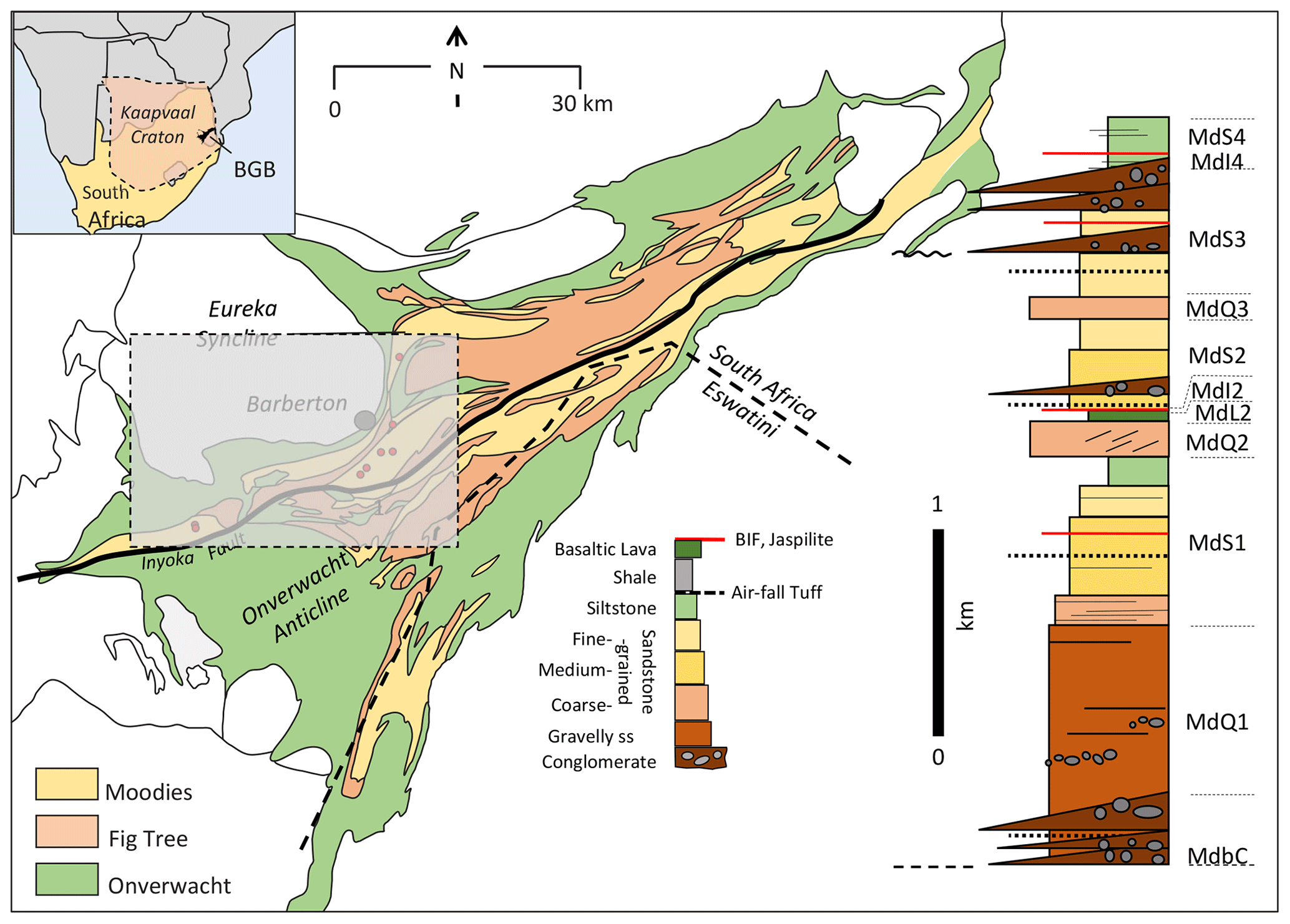
Figure 2Generalized geologic map of the BGB. The inset shows the location in southern Africa. The stratigraphic column to the right measures ca. 3.7 km in thickness and represents first-order lithology of the Moodies Group strata north of the Inyoka Fault. The area shown in Fig. 2 is outlined by the grey-dashed rectangle.
BASE (Barberton Archean Surface Environments) set out to produce a comprehensive data set of unweathered continuous cores from marine–terrestrial transitional strata from one of the world's oldest, well-preserved Paleoarchean units, the Moodies Group of the Barberton Greenstone Belt. The Barberton Greenstone Belt (BGB; Viljoen and Viljoen, 1969a, b, c; Anhaeusser, 1984; de Wit et al., 1992; Lowe et al., 1999; Lowe and Byerly, 2007; Anhaeusser, 2014) (Figs. 2, 3) of South Africa and Eswatini represents one of the two best-preserved records of the early Earth's surface environments, the other being the greenstone belts of Western Australia's East Pilbara Terrane. Strata of the BGB, ca. 3.57 to ca. 3.21 Ga in age, offer excellent conditions to reconstruct Paleoarchean (> 3.2 Ga) tectonic processes and surface environments.
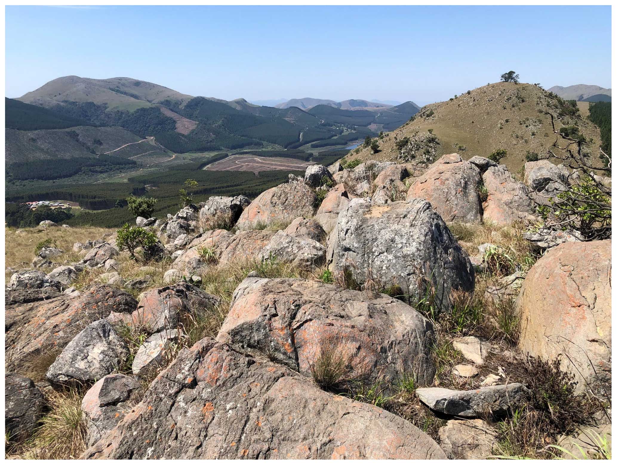
Figure 3Scenery of the central Barberton Greenstone Belt; the view is along the strike to the northeast. The region is partially covered by pine and eucalyptus plantations, interspersed by rocky and grassy hills which in part serve as natural fire breaks.
Because the stratigraphically coherent, mappable strata of the BGB exposed in good to excellent outcrops have been studied by numerous industry and government surveys and academic Honor's, MSc, and PhD theses, its rocks permit a deep understanding of local and regional stratigraphy. This, in turn, allows insights into Archean surface dynamics, e.g., weathering and erosion, tides, atmospheric composition and climate, the record of meteorite impacts, the early biosphere, and tectonic drivers.
1.2 Composition, stratigraphy, structure, and metamorphism of the Moodies Group
The Moodies Group (ca. 3223 ± 1 to 3219 ± 9 Ma; Anhaeusser, 1976, 1984, 2014; Eriksson, 1979; Eriksson et al., 2006; Heubeck, 2022; Heubeck et al., 2013; Heubeck, 2019; Heubeck et al., 2022b, and many others) is the uppermost stratigraphic unit of the BGB. It crops out over ca. 110 km length and 40 km width in the Barberton–Makhonjwa Mountains range with up to 1700 m relief. Strata reach up to ∼ 3.7 km in thickness and are dominated by quartzose sandstones but locally also include thick sequences of siltstones and conglomerates. Shales, banded-iron formations (BIFs), and volcanic units are uncommon. Strata were probably deposited within only ∼ 1 to 14 Myr (Heubeck et al., 2013; Heubeck et al., 2022b). They thus constitute a worldwide unique, very-high-resolution record of Paleoarchean surface processes, perhaps approximately comparable in overall temporal resolution to many Holocene geologic records.
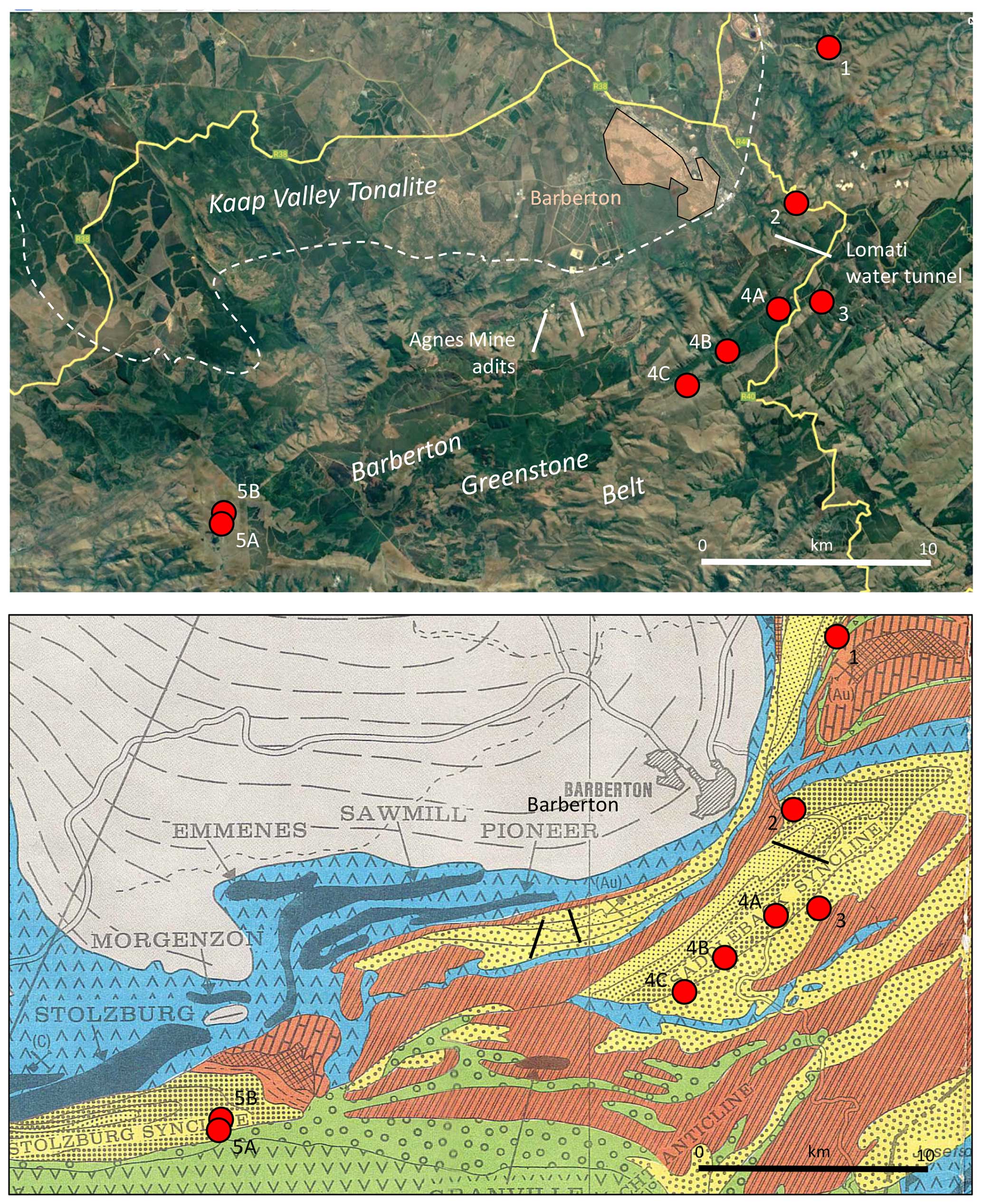
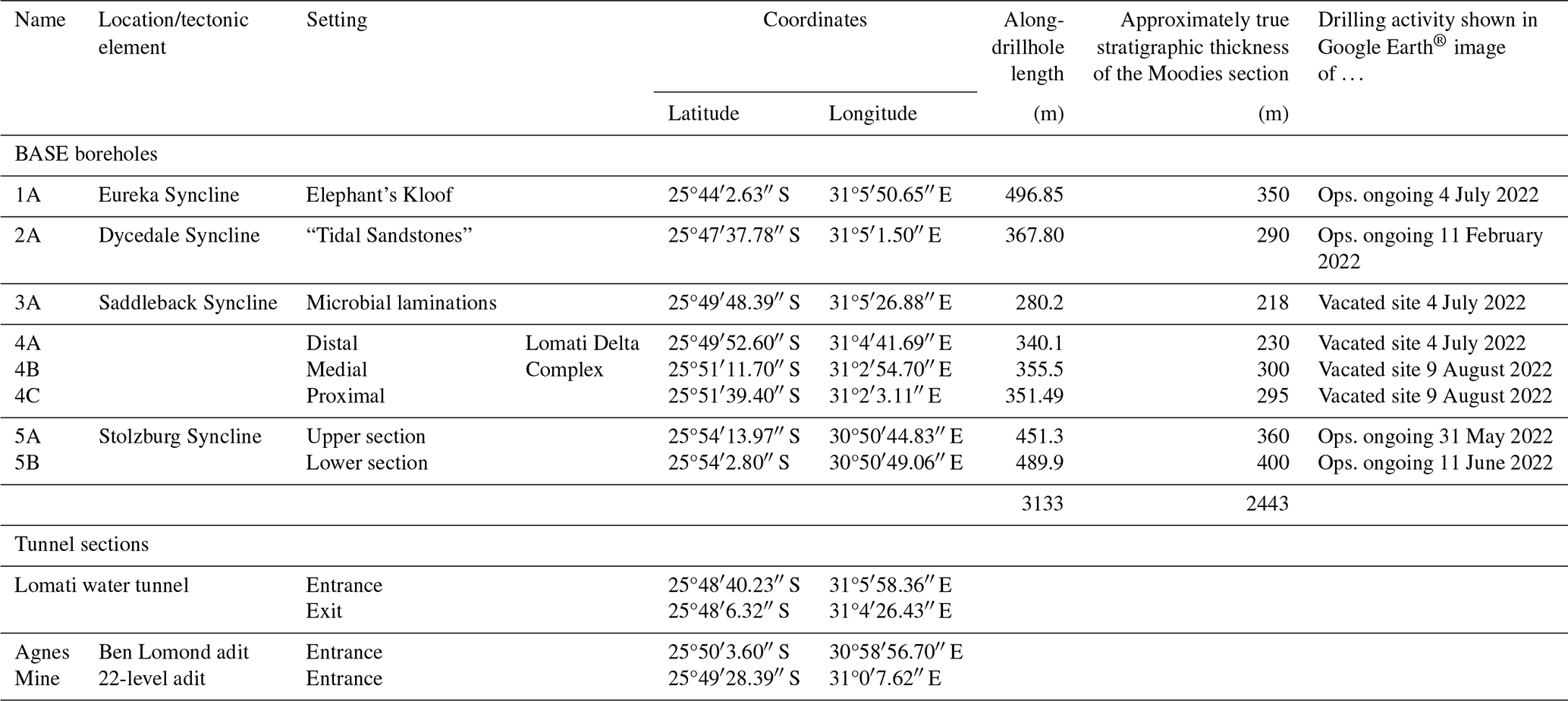
Figure 4Satellite image (© Google Earth) and geologic map (Anhaeusser et al., 1981) of the northern–central Barberton Greenstone Belt, showing the drillsite locations. All sites except Site 5A and Site 5B lie within about 12 km from Barberton. See the text for site descriptions.
All strata of the BGB, including those of the underlying Fig Tree and Onverwacht groups, are tightly folded and cut by major faults. The metamorphic grade is typically lower-greenschist facies (Toulkeridis et al., 1998; Tice et al., 2004). Maximum paleotemperatures from Raman spectroscopy of organic material reach ca. 320 to 380 °C. Widespread early-diagenetic silicification preserved microtextures and macrotextures in many locations, virtually without strain. Most Moodies strata are preserved in subvertically dipping or overturned limbs of regional-scale (up to 15 km long, up to 5 km wide) synclines (Figs. 2, 4; Heubeck and Lowe, 1994b; Lowe et al., 2012). Regional geologic mapping at the 1 : 25 000 scale has covered the central BGB (e.g., Lowe et al., 2012); numerous unpublished geologic maps (e.g., Gribnitz et al., 1961; Herget, 1964; Viljoen, 1963; Büttner, 1983; Paris, 1984; Daneel, 1987; Hose, 1990; Heubeck, 1994; Stutenbecker, 2014) provide details for areas of special interest. A fully representative Moodies stratigraphy exists only north of the greenstone-belt-axial Inyoka Fault because strata south of that fault are thinner and mostly experienced a higher degree of hydrothermal alteration (Reimann et al., 2021). All BASE drill sites are located north of the Inyoka Fault (Fig. 2).
Most outcrops in the BGB, despite appearing fresh, have been affected by surficial oxidative weathering, the effects of surface- or near-surface biologic activity (e.g., by endolithic bacteria), and/or near-surface oxic (groundwater) alteration. Even seemingly fresh sample locations, usually limited to steep cliffs and isolated exposures along streambeds, have been subjected to oxidative alteration. Previous drilling showed that weathering extends up to ∼ 20 m depth. Analyzing short (and usually stratigraphically poorly located) underground drill core provided by producing gold mines along the northern margin of the BGB has occasionally been successful (Hessler et al., 2004; Hessler and Lowe, 2006; Javaux et al., 2010; Nwaila and Frimmel, 2019), but advanced and high-resolution geochemical research on mine material is commonly compromised by poor geographic and stratigraphic constraints and carries the risk of local hydrothermal alteration or contamination by drilling fluids (Toulkeridis et al., 2015).
Analytical work in Moodies strata over the past 20 years, based on detailed field studies, has identified numerous geological features related to processes of the Archean biosphere, geosphere, atmosphere, and hydrosphere. These include extensive microbial mats in tidal and fluvial facies, concretions and biogenic reaction products in paleosols, weathering rinds, putative eolian strata, prodeltaic banded-iron formations, exquisitely preserved microfossils, and detailed reconstructions of shoreline and deltaic processes (Heubeck and Lowe, 1994a, b; Hessler and Lowe, 2006; Noffke et al., 2006; Javaux et al., 2010; Simpson et al., 2012; Heubeck et al., 2013, 2016, 2022b; Homann et al., 2015, 2016, 2018; Nabhan et al., 2016a, b; Nakajima et al., 2016; Stutenbecker et al., 2019; Janse van Rensburg et al., 2021; Eulenfeld and Heubeck, 2023; Heubeck et al., 2023; see Heubeck, 2019, for a review). Because of the straightforward lithostratigraphic correlation possible in Moodies strata north of the Inyoka Fault between terrestrial, transitional, and marine Moodies strata, physical, chemical, and biologic processes can be traced well beyond the marine record that usually obscures atmospheric processes.
The drillsite selection was based on previous detailed geological mapping by Heubeck and his students. Existing regional geophysical data (gravity and magnetics; Burley et al., 1970; Darracott, 1975; de Beer et al., 1988; de Beer and Stettler, 2009; Kütter et al., 2016) are handicapped by low resolution because the area has a mountainous topography, subvertically dipping strata, strongly varying unit thicknesses and lithologies, and diagenetic alteration fronts. Aerial and ground magnetic surveys had been scheduled for the five drill sites of the BARB International Continental Scientific Drilling Program (ICDP) project conducted in 2011 (Nick Arndt et al.: Peering into the Cradle of Life: Scientific Drilling in the Barberton Greenstone Belt, South Africa, ICDP Proposal, unpublished, 2009) but were never implemented because geological characterization proved sufficient. Geophysical data will nevertheless be crucial for future strategic projects intending to constrain the large-scale (e.g., shallow or deep, symmetric or asymmetric) structure of the BGB and to delineate major structural breaks at depth.
The aims of BASE were to study Archean surface environments which were crucial to forming the foundation of subsequent evolutionary, sedimentary, and tectonic processes. Major targets of investigations were
-
conformable terrestrial–marine transitions for environmental proxies;
-
diagnostic lithologies (such as various paleosols, nearshore BIFs, evaporites, and basaltic lavas) for their environmental significance;
-
the compositional, facies, and morphological variability of thick and laterally extensive microbial mats; and
-
sedimentary and mineralogical responses to surface variables, such as tides, climate, potential meteorite impacts, and radiation.
Principal questions included the following.
-
What were the ecology, 3-D morphology, and metabolism(s) of abundant (oxygenic photosynthetic?) microbial mats preserved in minimally compacted tidal-facies sandstones? Are these properties recorded in their C-isotope microstratigraphy? What were the preservation pathways, origins of early-diagenetic chert, and degrees of thermal overprint? Can we constrain net O2 production rates and the early N cycle?
-
What is the (cyclo)stratigraphic and microfossil record of fine-grained marine and prodelta sediments? What is the origin of its clay minerals? How do coastal BIFs and jaspilites relate to nearby tidal microbial mats? What does the paleomagnetic record imply about the nature and strength of the Paleoarchean geomagnetic field?
-
What global surface conditions can be inferred? What was the redox state (sulfate, redox-sensitive metal isotopes), temperature and composition of ocean water, of early-diagenetic fluids, and of the atmosphere?
-
What can we infer about the role and significance of terrestrial weathering from proxies of physical and geochemical weathering, the composition of variable paleosols, the architecture of eolian strata, and the traces of evaporites and microbial metabolism(s) in terrestrial sediment?
Site selection
Site selection took place during an ICDP-funded field workshop from 5 to 10 October 2017 outside Barberton which was attended by 48 scientists from 11 countries and 10 local stakeholders. Sites had to (1) provide information that could not be obtained from surface outcrops (contacts, unweathered material, facies transitions); (2) record environmental and geochemical processes related to surface conditions of the Archaean Earth through key sedimentary and geochemical proxies; (3) be chosen on the basis of significant prior field studies and laboratory work; (4) minimize structural complexity and avoid zones of known hydrothermal alteration; and (5) allow technically feasible drilling at economically reasonable costs.
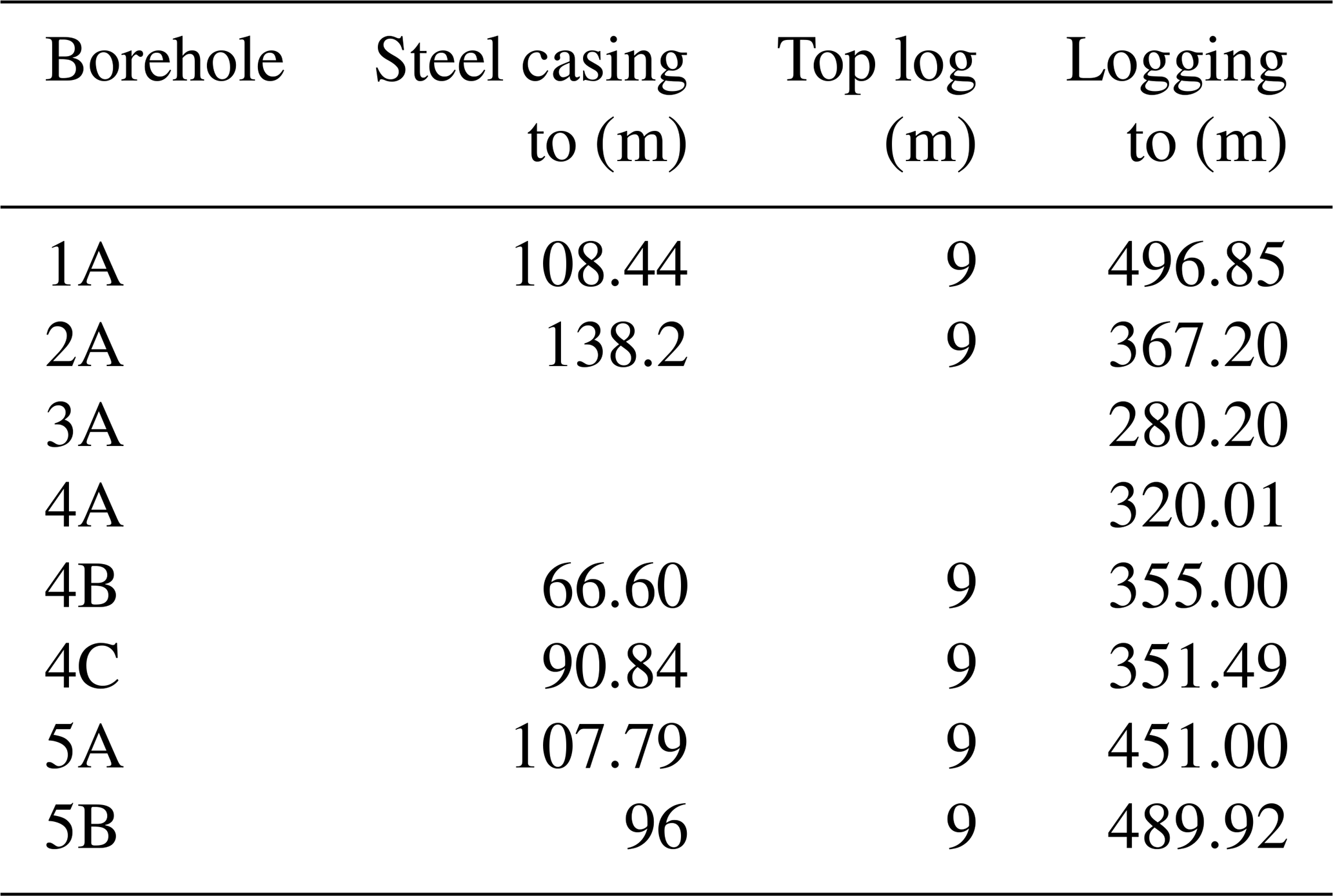
The full ICDP proposal included detailed site characterization which spelled out borehole-specific scientific issues, specific targets, and logistical aspects, along with geologic strip maps and predicted geologic profiles along the drill paths. All boreholes were oriented perpendicular to the strike of bedding, drilled at an inclination of 45° from the horizontal and against the dip of bedding in order to maximize the stratigraphic thickness intersected by the borehole. Drilling in overturned sections was stratigraphically base-up, progressing from older into younger strata. Because the central objective of the drilling program was to obtain a continuous and unweathered core (rather than the identification of facies from diagnostic sedimentary structures, better done on outcrop strata), drilling the bulk of the sections was done at a comparatively thin core diameter (PQ3 = 83 mm diameter core with a 122.3 mm diameter hole).

The five stratigraphic sections selected for drilling are all located within a ca. 30 by 20 km area close to Barberton (Fig. 4; Tables 1, 2) and can be stratigraphically correlated (Fig. 5).

Figure 5Schematic stratigraphic columns of the Moodies Group, showing the architecture of the Moodies Group and correlation of the sections (modified after Heubeck et al., 2016).
4.1 Permitting and stakeholder buy-in
Christoph Heubeck started contacting and briefing local stakeholders (World Heritage Site administration, mining companies, local and regional government, and local associations) in 2015 and 2016. The briefing was to ensure that these entities were aware first-hand and early of the scientific and non-commercial objectives of the proposed drilling program. Stakeholders were invited to and attended the Barberton workshop in 2017. While funding was organized from 2018 through 2021, the coordinator obtained formal letters of approval from relevant property holders and letters of support from professional societies and government agencies. Astrid Christianson at Barberton Community Tourism led a “grassroots” movement in Barberton by keeping municipality and district officials informed. Christoph Heubeck held (usually while conducting yearly field work) public evening talks to the Barberton Mountain Land branch of the Geological Society of South Africa, chaired by Chris Rippon. Drilling was originally planned to begin in winter 2020 to take advantage of the climate, but obtaining landowner approval for drilling proved to be more time-consuming than anticipated. Nic Beukes at the Centre of Excellence for Integrated Mineral and Energy Resource Analysis (CIMERA) in Johannesburg published a drilling tender, “Scope of Drilling Services Required”, in June 2021. Bids were received in July, and a selection was made by a committee in August 2021.
Nic Beukes obtained documents certifying the non-commercial, tax-free status of the project from the South African government and set up the accounting infrastructure at the CIMERA office at the Department of Geology, University of Johannesburg. He also lobbied in Pretoria to have South Africa rejoin the ICDP.
On 7 and 8 April 2021, approximately half a year prior to the scheduled start-up, Nic Beukes and Christoph Heubeck briefed all stakeholders on the objectives and structure of the drilling program, followed by a field inspection of all eight proposed drill sites (Table 1). This also served to clarify practical questions of access, security, clearing of trees, fencing, water supply, location of the field office, and crisis protocols.
The Barberton region has had a long history of exploration for (and mining of) gold from the hydrothermal mineralization in deep-reaching subvertical ductile–brittle shear zones, mostly along the northern margin of the greenstone belt. The mines make up the economic backbone of the town's economy. Many residents are thus familiar with drilling as part of gold exploration. For these reasons, the scientific, non-commercial, curiosity-driven nature of this project had to be made widely known, an unfamiliar concept for many. Because seven of the eight BASE boreholes were located within the newly declared Barberton Makhonjwa World Heritage Site, it was also essential to communicate that this project was linked to the objectives and philosophy of the World Heritage Site. The Education–Outreach–Publicity (EOP) component of BASE was large and is spelled out in detail in the operational report (Heubeck et al., 2024a). The drilling and scientific crews devoted considerable resources to this aspect, including a permanent legacy in the form of a new room added to the Barberton regional museum after the end of operations.
4.2 Site inspections
Site 1 was located on an active mine property with more than 100 years of continuous operations involving heavy moving equipment. Site 2A was in a sandy flood retention depression immediately next to a parking lot adjacent to the paved R40 road. Sites 3A, 4A, 4B, and 4C were on or next to forest roads in commercial pine and eucalyptus plantations. Sites 5A and 5B were in grassland near an abandoned homestead (Fig. 6).
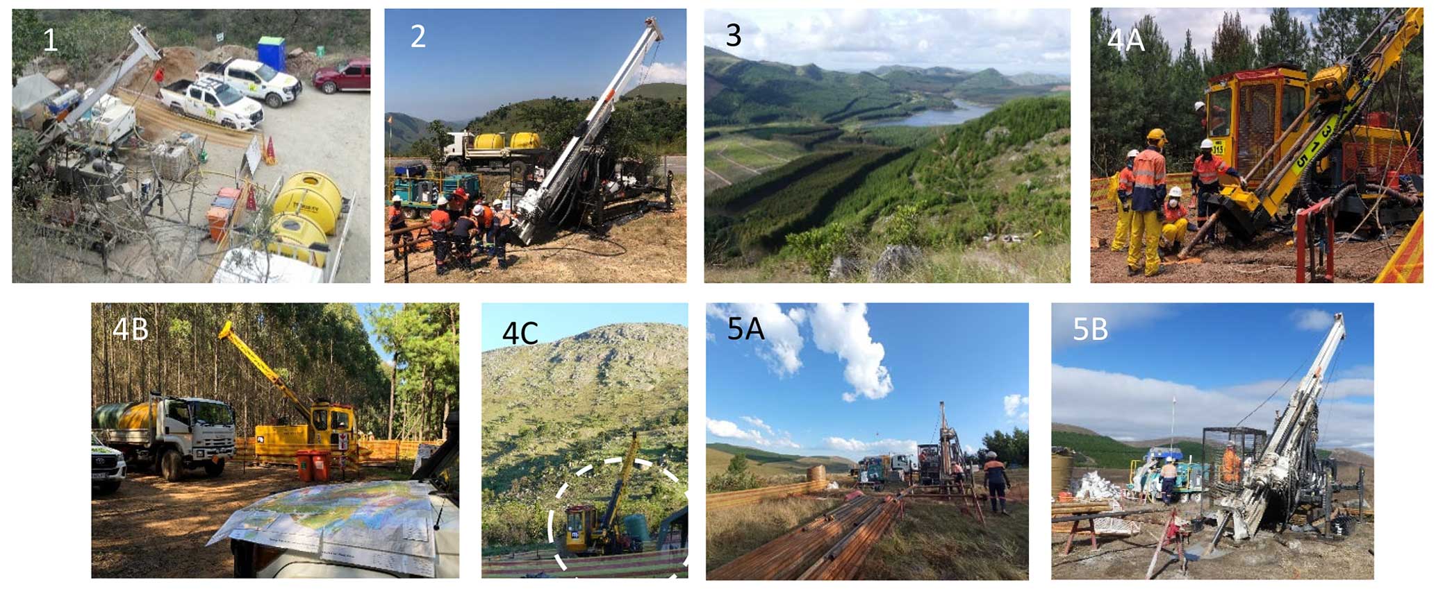
Figure 6Locations of drill sites (numbered photographs). Site 1 is located in the hairpin turn of a mining road, Site 2 next to a parking lot of the paved R40 road. Sites 3, 4A, 4B, and 4C are located within commercial plantations, Sites 5A and 5B on open grassland.
The Ecological Control Officer (ECO) conducted a baseline environmental survey for each site, inspected sites using a previously agreed-upon checklist, inducted drilling staff, visited the sites during drilling operations to conduct audits, conducted site visits to clear any remaining issues after completion of the rehabilitation program, and wrote final reports on all the sites. (Site 1 did not receive a final report because its location in a hairpin of a mining road made any changes moot.) Each site was handed back following a final joint inspection by a drilling contractor's representative, the ECO, and the landowner's representative.
4.3 Preparation of core processing and local infrastructure
Nic Beukes, Christoph Heubeck, and Astrid Christianson started to actively look for a site to process the core in March 2021. The BIAS (Barberton Iron And Steel Inc.) Hall, a large former industrial hall in downtown Barberton, caught our attention. The owner, the Department of Arts, Sports and Culture of Mpumalanga Province, granted free use of about one-third of the underused central segment of the hall for core processing. The hall turned out to be an excellent location for core processing and outreach.
Christoph Heubeck arrived about a month prior to the start of drilling to set up accommodation and the processing center and to speak personally with landowners. Water, electricity, Internet, and site security were quickly installed in September and October 2021. Nic Beukes arranged for a core rock saw and associated equipment (tables, a steel cabinet, field chairs, etc.) to be delivered from UJ stores in September 2021. The front half of our space was set up as an informative geological exhibition (Fig. 10).
4.4 Initial mobilization, water, accommodation, site preparation, and crew
The drilling contractor initially assigned two track-mounted drill rigs (MDX 315 from 15 November 2021, MDX 318 from 26 November 2021) to the task. They were delivered by flatbed truck to an offloading site as close as possible to the drill site and then usually driven under its own power to the drill site along forest roads, up to a distance of a few kilometers. That drill site had been set up a few days before (flagging, limits, safe area, parking, toilets, staffing board identifying responsibilities and contact information, tent; Fig. 7). Upon arrival of the rig at the site, the geologists marked the precise drilling direction.
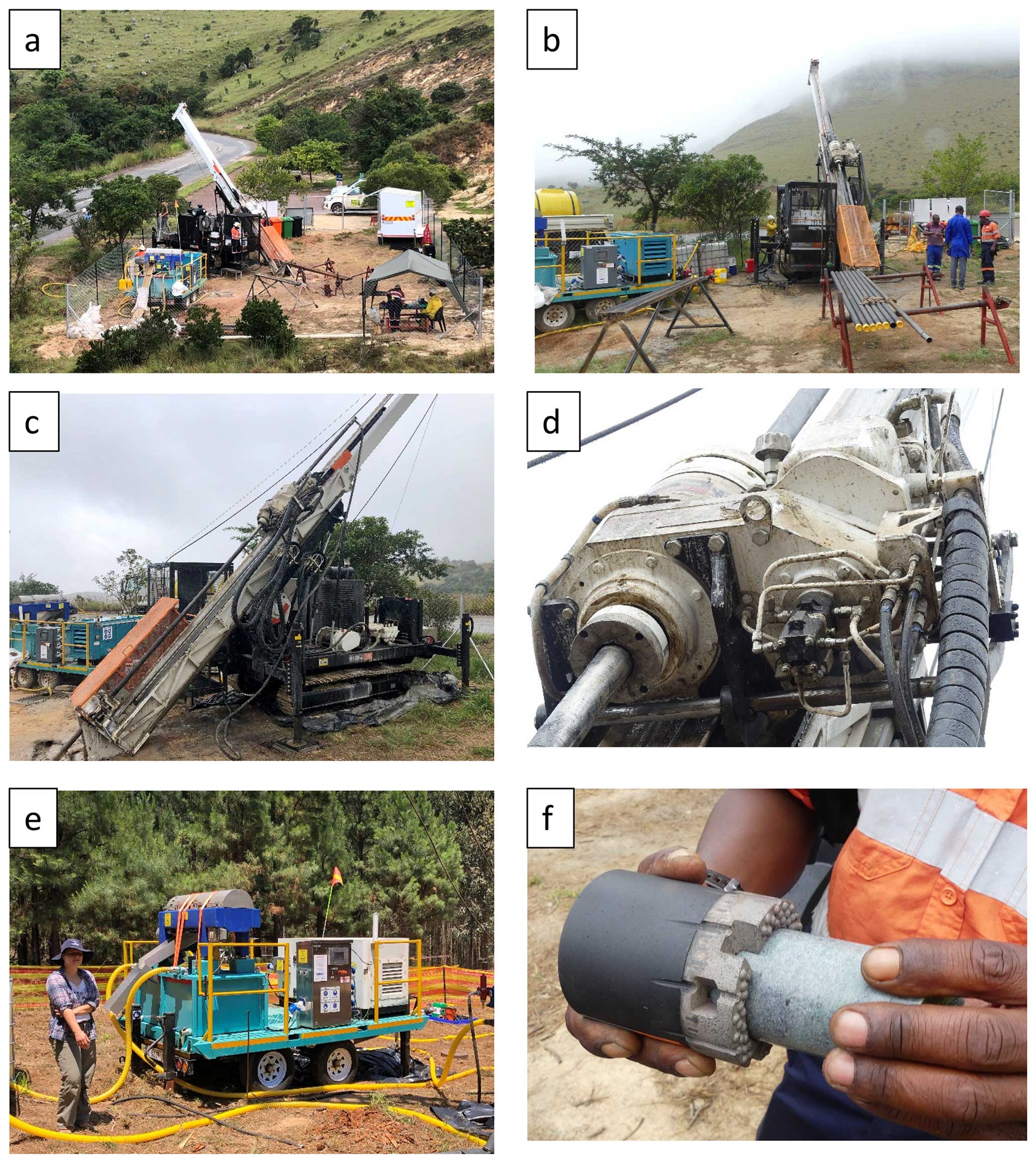
Figure 7Drilling setup at Site 2. (a) Overview of the site: from left, bagged sludge, trailer-mounted Solid Removal Unit (SRU), drill rig MDX317, and the tressels and workbench for the drill pipes, tented work area, and storage trailer. The entire site is fenced. (b) Site overview. (c) Track-mounted drill rig. (d) “Top drive”. (e) SRU. (f) Rotary drill bit with a piece of core.
A compact, trailer-mounted Solid Removal Unit (SRU) was installed at the site to process the drilling mud (Fig. 7e). The SRU centrifuged the sludge-like cuttings, which were bagged and removed as solids. They were never studied and were considered of no use to the project.
The contractor supplied a water truck capable of carrying 5 t of water. Each borehole had an assigned water extraction point, typically a 15 to 30 min drive away. Water consumption was far higher than anticipated due to the numerous fractures encountered, making more water runs necessary. The roads, softened by the unusually long and intense rainy season of 2021/2022, were occasionally too slippery to safely drive, causing additional delays.
The on-site drilling site manager, together with his rig supervisors, actively searched for crew accommodation close to the drill sites. SAPPI kindly made some of their forestry brick houses available. At these sites, the contractor also parked one or two short containers to store tools, trays, electrical equipment, and occasionally cores.
Each site was cleared of stumps and flammable vegetation. The site was leveled and delimited with flagging tape; parking, safe area, smoking area, and work area were marked and the equipment placed and connected. Signs were installed, a sump was dug, and the toilet was installed. Fifty-five-gallon drums with secure, clamped lids and oil-absorbent pads were put ready for oil or solvent spill clean-up. All drums and barrels were placed in a tray. The SRU was installed and hooked up to the generator.
Each rig was headed by a site supervisor and had a crew of five with specific functions (operator, rig assistant, scribe, assistant, safety representative, first aider, snake handler; Figs. 6–8). Operations, particularly core handling on site, were done exclusively by the drilling crew; visitors stayed outside the fenced perimeter. The conspicuous Site 2, next to the paved road R40 and only a few kilometers from Barberton, was fenced with a construction-site-quality fence by a local contractor and guarded overnight by security (Fig. 7a).
5.1 Coring plan, drilling schedule, and progress
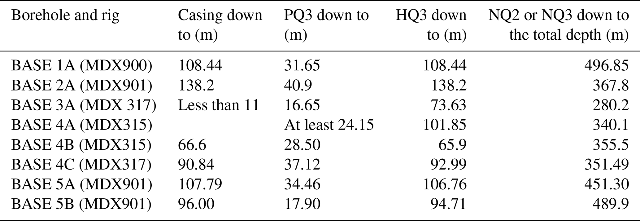
BASE boreholes were drilled using water-based hydrocarbon-free drilling mud. Drilling at each site started with PQ3 core size (83 mm core and 122.6 mm hole diameter) to allow installation of surface casing for groundwater protection. Once the weathered zone had been drilled through, the casing was set, typically between 60 and 100 m depth. Drilling continued from there for some depth on HQ3 (63.5 mm core and 96 mm hole diameter) before switching to NQ3 (47.6 mm core and 75.7 mm hole diameter) to improve drilling rates. The contractor's drilling operations manager decided the depth at which the drill pipe diameter was changed (Table 3).
The variable core diameters PQ3, HQ3, and NQ3 corresponded to core trays with four, five, and six grooves, respectively, each 1 m long. While trays with four PQ-diameter cores had to be carried by two persons, the large majority of core trays handled during processing could be readily handled by a single person because they contained only six half NQ diameter cores. This significantly eased the workflow.
The core was drilled with conventional diamond-impregnated bits, giving a core diameter which would fit into wireline inner tubes (the wireline diamond drilling method). The core is extracted by sending a wire cable down through the rod string with a spear-shaped overshot device at the end. This device would clip itself over the swivel head assembly, essentially a spike at the top of the core barrel. This action disengages the latches of the inner barrel assembly from the outer barrel and the drill pipe, freeing the inner tube with the core inside. Thus, the core barrel could be rapidly winched up to the surface. Only when the bit needed to be replaced was the entire rod string brought to the surface (“tripped”).
The initial drilling progress of ca. 5 to 8 m d−1 was far slower than the contractor had predicted, so that the contractor assigned a third, new drill rig (MDX 317) on 3 February 2022. These measures and continuous optimization in the drilling parameters significantly improved the core recovery and drilling rate. However, logistical problems with moving the rigs between locations due to the low availability of flatbed trucks, washed-out tricky roads, and lack of an adequate water supply, together with the very rainy summer of early 2022, caused additional delays. Drilling ended on 26 July 2022, with a total of 3135 m drilled and 2903 m of core recovered. All scientific objectives of the project were achieved; all boreholes had reached their planned total depths.
Moving rigs between sites from the end of drilling to collaring at a new site took approximately 10 d, including weekends. This included pulling the drilling assembly, flushing the hole, filling the hole with clean water, conducting geophysical logging, extracting the surface casing, driving the rig on its own tracks to a location where a flatbed truck could load the rig, transferring it to an offloading point, driving it on its own power to the new site, setting it up there, and properly orienting the rig.
5.2 On-site core handling
The 3 m long core barrel was laid on tressels and the drill bit screwed off (Fig. 8). The barrel was opened at its lower end and its upper end hooked to a cable which was slowly raised using the winch, causing the core to slide out of the core barrel under its own weight. The core, usually in several pieces and caught by two helpers, slid into a 3 m long V-shaped angle iron laid on the grooved tressel. All the core pieces were carefully moved together. The full length of the core was accurately measured with a steel tape. This length is the “core recovery” (as opposed to the drilled depth, the length of which is called the “advance”). Once the core barrel had been emptied, the core was washed and transferred to a plastic core tray, taking care to maintain the right order and correct orientation of each piece. If the last piece was too long to fit in the row, it was broken with a hammer tap. The driller's depth for each run was demarcated by a plastic depth-marker block. The driller recorded the end-of-run depth, drilling advance, and core recovery on this plastic block and included these numbers in the daily drilling report.
Core was recovered each time the core barrel was full, if the bit had worn out, or if the water channels in the bit had become blocked. The depths were always calculated on a run-by-run basis. The core depth was calculated by the “stick-up” procedure. The data for this calculation were recorded for every run, whether it was a full or partial core barrel. The latter would apply if, for example, the drilling had to be prematurely stopped because of a bit failure or water blockage.
Accurate depth measurements were recorded by the rig supervisor in his daily report sheet by adding the lengths of all rods, couplings, core barrels, shells, and crowns in the hole and subtracting the length of the rod string protruding from the hole and above a base reference plate or mark. This system worked well.
A drilling rig produced between three and six core trays per day, amounting to between 12 and 36 m of core. Because friable cores were particularly susceptible to breaking by vibration during transport, core trays had to be tightly stacked, covered by a lid, and securely strapped down in the vehicle. The driver had to drive carefully and take care to avoid the many potholes.
5.3 Rock quality
The quality of the drilled cores varied more than anticipated for several reasons: (1) the weathering zone was thicker than predicted, causing the rock to be clayey and friable; (2) the degree of natural fracturing was higher than predicted; (3) deep oxidation along fractures and faults reduced rock strengths, even at depth; (4) the drill crews were inexperienced with this type of rock; and (5) the first cores, already affected by faults or hairline fractures, were transported over potholed dirt roads and were not fully secured. This caused some additional breakage. As a result, a substantial number of drill cores arrived broken. Such core had to be time-consumingly rearranged, taped, and marked. The rock quality index (RQI) was entered into the database to describe an aspect of rock quality.
5.4 Activities after reaching the total depth; logging
Downhole geophysical logging was done by Wireline Africa Inc. A wireline unit logged each cleaned and fluid-filled borehole, usually the day after the rig had pulled the drill string (Fig. 9a, b). Logging usually took 2 d. The final few meters of casing were left in the hole, and the annulus was sealed using a viscous bentonite clay mixed with cement. The borehole was then covered by an oval steel cap with the borehole name (Fig. 9c, d) which was welded on in June and July 2022. These caps were mounted a few decimeters below ground level to be completely unobtrusive. At an inspection in March 2023, no caps or signs of drilling were visible.
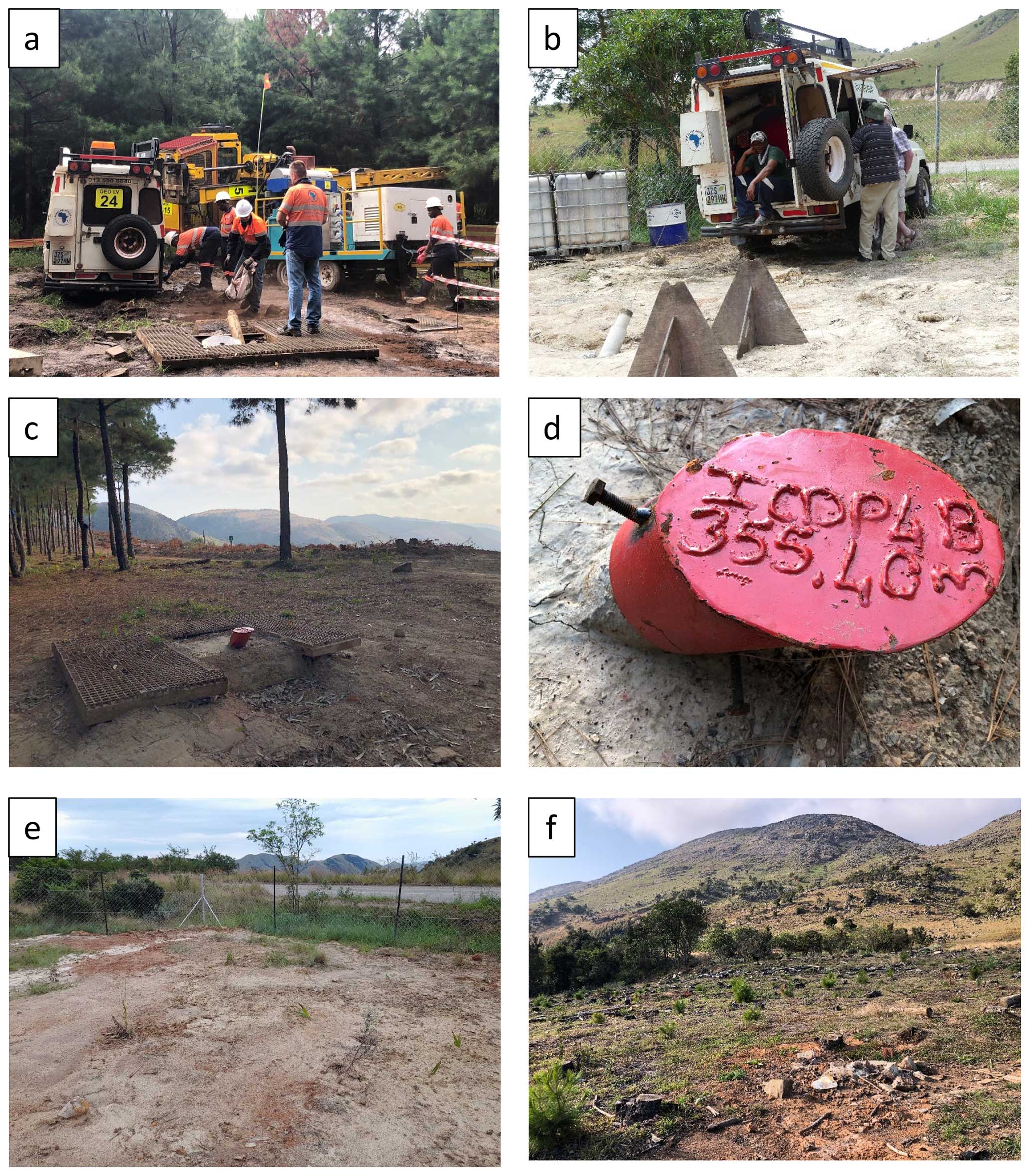
Figure 9Post-drilling site operations. (a, b) Logging. (c, d) Site 4B with the cap welded on; the steel grating is yet to be removed. (e) Site 2 with the equipment removed; the site still needs to be raked and the fence removed. (f) Site 4C rehabilitated.
After departure of the drilling rig and loading of the remaining site equipment, the ground was cleaned and raked (Fig. 9e, f). Minor spills were taken care of by absorption material.
6.1 Core handling workflow
We had set up a core processing workflow in BIAS Hall by stations, arranged clockwise. Each station had at least one principal attendant, a working area, and a waiting area (Fig. 10a, b). The regular crew consisted of five scientists and three operators (Fig. 11).
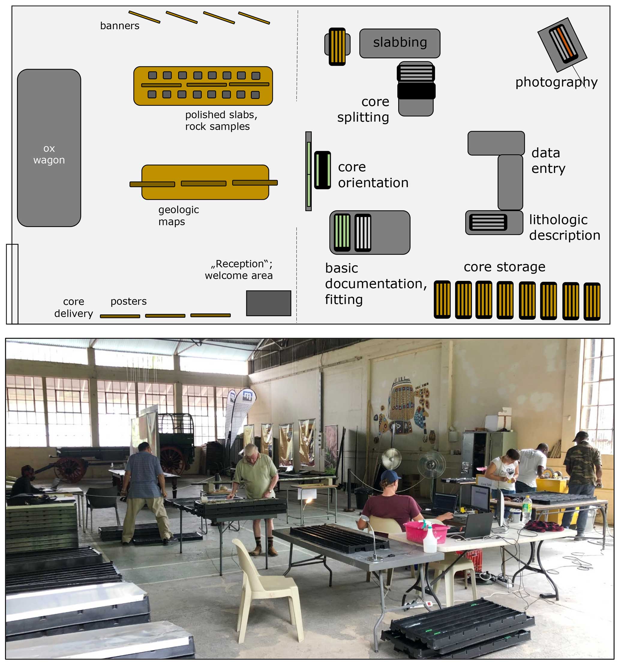
Figure 10Workflow of core processing in BIAS Hall. The “reception desk” is visible to the left, staffed by Phumelele Mashele. The exhibition area and the museum's ox wagon are visible in the background. Chris Rippon, with his back to the camera, is working on core orientation, Rod Tucker on basic documentation and fitting. Derick Dludlu and Musa Mavimbela (far right) are slabbing core at the yellow core saw. Dora Paprika is in front of them, slabbing and labeling the core. The photography stand is out of view to the right. Ryan Tucker is entering data into the mDIS. The lithology description table in the foreground is usually occupied by Christoph Heubeck.
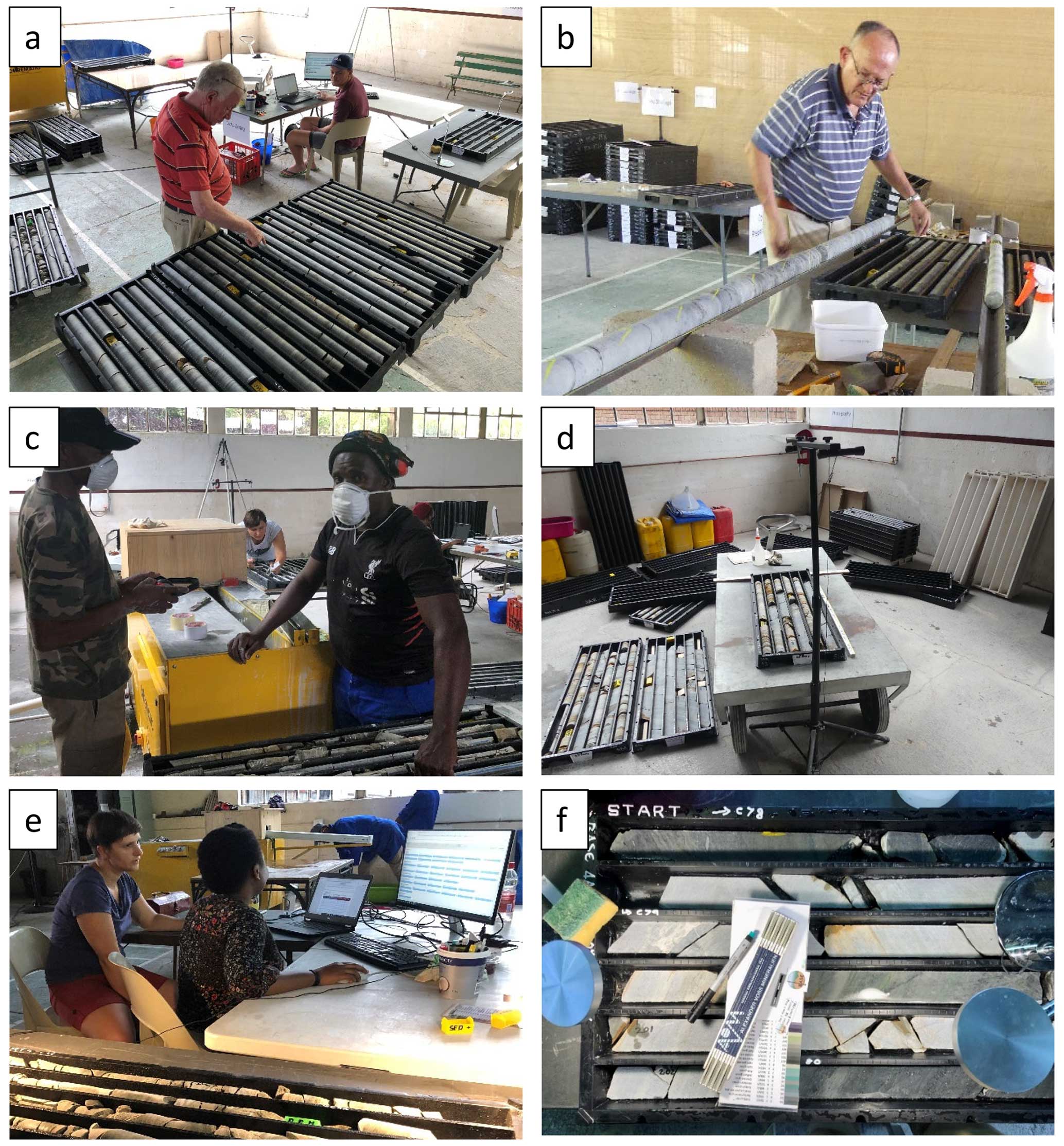
Figure 11Stations of core processing in BIAS Hall: (a) re-packing; (b) orientation; (c) slabbing and splitting; (d) photography; (e) data entry; (f) lithological description and close-up photography.
6.2 Reception, repacking, labeling, mobile Drilling Information System (mDIS) entry, and photography
After offloading from the vehicle, core trays were briefly inspected for completeness and order and stacked by drill site. Sections and individual core pieces were then moved up to the last (usually partially empty) core tray of the previous day. Repacking was done to create a continuum and to avoid having long empty rows in core trays. The black plastic core trays were neatly labeled using a white marker (box numbers, core run numbers, “START”, arrows).
Basic core and section data, e.g., I lengths of each core, their sections, and their number of pieces were entered into the ICDP's mDIS, a database system for capturing and curating basic data generated during the project's operational phase (Fig. 11a). Notably, the mDIS is not based on absolute depth values (which can change during a project's lifetime due to adjustments) but on “core number” – the “section number of the core in the core tray” and “number of a piece of core within a section”. Only then are core sections measured and labeled with lengths; the system automatically adds all section lengths to arrive at dynamic depth values. Several report forms allow data output in tabular, graphic, or digital formats and printing of QR code labels for sampling.
Immediately after repacking, the full core trays were photographed dry and wet to record presence, core continuity, and rock quality. The existence of these “book-in” photos proved helpful later when core segments disintegrated, were occasionally mishandled, or were misplaced during processing.
The photography station was located on a trolley next to a lifting frame which had been fabricated from a tripod and a horizontal outlier, the end of which held a smartphone at a fixed location and height (Fig. 11d). The trolley could easily be reoriented to optimize illumination. The core and tray were wiped clean, and a data bar showing the hole number, scale, and reference color bar was placed below the core tray.
6.3 Orientation
After returning from book-in photography, core pieces were taken from their tray and placed on a 4 m long V-shaped angle iron which had been set on nudged bricks between two tables. The core was rotated and moved together for a best fit between pieces (Fig. 11b). We oriented core by hand based on the angle at which the regional bedding inclination (known from outcrops) intersected the borehole, which was inclined at 45° below the horizontal. Chris Rippon oriented all core segments on the angle iron such that the bedding lowpoint faced downhole. Where the bedding was poorly distinguishable, estimates of proper fits were made from the end pieces of previous core pieces. Where core was badly broken, pieces were taped together. Once oriented, a yellow “cut line” was drawn on top of the horizontally resting core using a 1 m steel ruler. This defined the left and right halves of the core. Yellow arrow marks () were drawn on the top of the core to indicate the direction to the drill rig. Parallel red and blue lines were drawn on the left and right halves. Full meter numbers were marked on the outside of the core in black. The core was returned to its tray and transferred to the core saw waiting area.
6.4 Slabbing, tray labeling, separation of archive and working halves, and repeat photography
The core saw operators took a marked core segment from its tray, shortened it if necessary with a hammer to fit in the 30 cm long slotted cradle, and placed the core such that the yellow cut line faced upward. The tray was automatically drawn into the (housed) saw blade by a toothed pulley (Fig. 11c). An operator retrieved the slabbed core in its cradle on the other end of the saw blade housing and returned both halves, still placed next to each other, into the core tray. A self-made sump with a pool pump, bought from a local hardware store, circulated water which was laced with a diamond saw cutting-fluid additive.
Once core from a tray had been completely slabbed, it was placed on a large table next to an empty core tray. A helper carefully duplicated all markers from the original core tray to the other tray using a white permanent marker and added a “W” (working) and an “A” (archive), respectively, to the core tray number. Usually, the left half of the split core and any core pieces too broken to be moved remained in the original tray (now labeled “A”: archive). The right half of the split core was transferred to the new core tray (labeled “W”), which became the working half destined for shipping to Germany. At this point, both trays also received handwritten labels on the front and depth information on the side. Finally, and prior to photography, the black full meter markings from the outside of the core were duplicated on the slabbed core faces.
Both the archive and working halves and their trays with the data bar were cleaned and photographed again wet and dry (Fig. 11d). Then, the tray with the working half moved to the storage section, the archive half into the lithology waiting area.
6.5 Geological core description and close-up photography
For its initial geological description, a core tray was placed on a table, illuminated by two high-powered LED desktop lamps; the core was sprayed with water. A 90° seating arrangement between the describing geologist and the data entry operator turned out to be most effective at transmitting the information while the very noisy diamond saw was running (Fig. 11e).
Core description used the ICDP's mDIS. Information was entered in two categories: lithofacies and special features. The lithofacies terminology included lithologic units (e.g., sandstones, interbedded sandstone-shale couplets, conglomerates) combined with specific subsets of sedimentary structures (laminated, cross-bedded, with microbial mats, mudchip-bearing, grain size trends, etc.). We attempted to transfer these terms between boreholes but found that differences in primary depositional facies, degree of weathering and fracturing, cementation, and hydrothermal alteration were large enough to change lithofacies appearances significantly, making new definitions a common necessity. This approach reduced comparability between borehole lithologies but allowed detailed recording of subtle lithologic and textural changes. If workload and core variability allowed, we identified all lithofacies units > 2 cm in thickness. They differed from each other by lithofacies, contact type, grain size, sorting, and/or code from the Munsell rock color chart. Typical units, however, were 7 to 12 cm thick; unusually thick units reached up to 40 cm.
The category “Special Features” included non-pervasive primary sedimentary features of a lithofacies such as isolated clasts of various types and sedimentary structures (e.g., mud cracks, mud clasts, rhythmic bedding, shale coatings, load structures, fluid-escape structures, cross-bedding, erosional scours, slump folds, microbial mats, concretions). Post-depositional features in this category recorded slump folds, fractures, faults, veins, and (pyrite) mineralization which were not or insufficiently included in the definition of the lithofacies nomenclature (e.g., lithofacies: cross-bedded medium-grained sandstone; special feature: quartz-veined). Dora Paprika, our principal data manager, oversaw the database and kept digital order.
Many close-up photographs of the freshly slabbed and sprayed core on the lithology description desk were taken (Fig. 11f). Each photograph included a small handwritten label stating the borehole, core, section, piece, arrow pointing in the stratigraphic younging direction, and depth; the stated depth on that label was always the measured depth which was marked in handwriting on the core. It constituted the depth of the label, not of the feature. The text of the label was always oriented so as to face stratigraphically upward. These close-up photographs proved to be useful in subsequent core description.
6.6 Archiving, preparation for shipping, and shipping
Once cores had completely dried again, trays were stacked about 20 trays high in separate stacks (working, archive). We checked whether labeling was complete. Inexpensive pallets were ordered locally. Trays fit snugly on top of each other such that they immobilized cores. Only the topmost trays received a lid. Tight steel band strapping prevented the jostling of trays during transport.
A total of 29 pallets, each with two stacks of about 12 core trays each, were shipped to the CGS's National Core Repository in Donkerhoek in August 2022. This archive is the legislated custodian of all geoscience data in South Africa. It provides accessible, safe storage for the core and is a resource for future research.
Twenty-eight pallets from the boreholes loaded with 503 core trays plus one pallet with boxed samples from the tunnels left Barberton on 30 September en route to Germany and arrived at the Berlin Core Repository of the Bundesanstalt für Geowissenschaften and Rohstoffe (BGR), a federal agency, on 30 November 2022.
The working core is currently stored at the Nationales Bohrkernlager für kontinentale Forschungsbohrungen, Wilhelmstr. 25–30, 13593 Berlin (Spandau), Germany.
The samples from the probed tunnel sections were shipped to Jena and processed there. Chips and thin sections are archived in the departmental archive, care of Christoph Heubeck.
7.1 General remarks
The drilling campaign drilled a total of 3135 m, recovering 2903 m of core and yielding a recovery rate of 93 % (Figs. 12–20). Lost core material consisted of sections in the weathering zone which were not cored (5–70 m thick) and core broken due to oxidative weathering or due to extensive fracturing at depth.
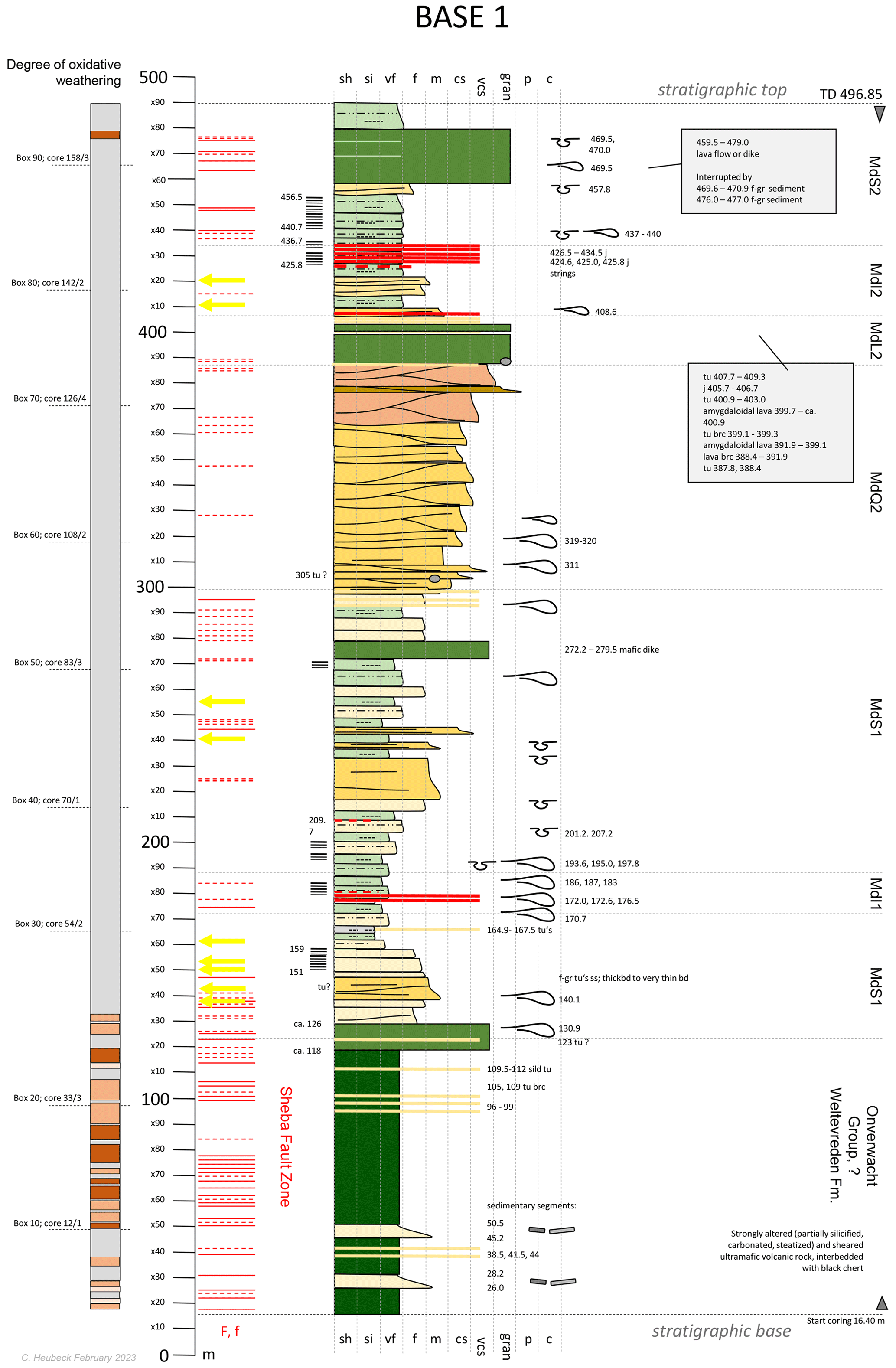
Figure 12BASE 1A drilled 295° from true north and base-up through the eastern, west-facing limb of the Eureka Syncline on the grounds of Fairview Mine. The borehole spudded in the Sheba Fault Zone at 25°44′2.48′′ S, 31°5′51.08′′ E and was drilled from 16 May through 26 July 2022.
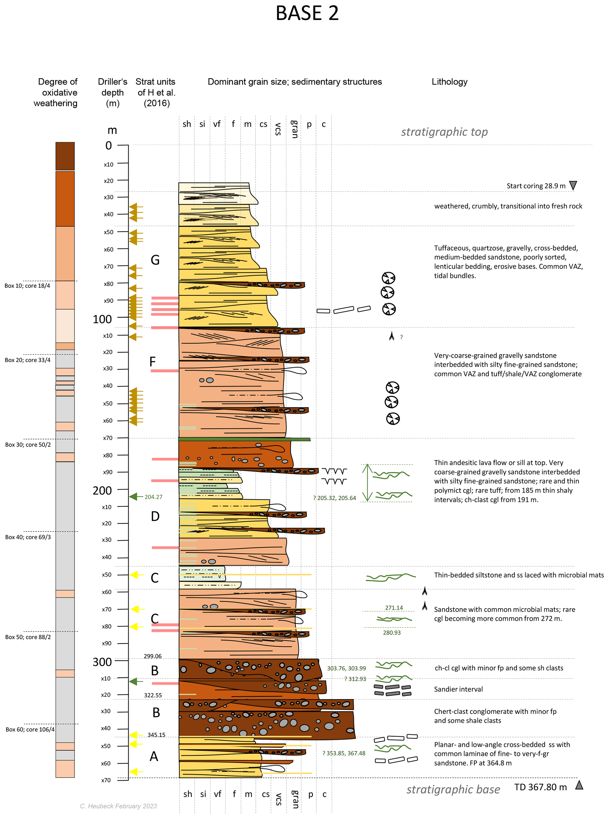
Figure 13BASE 2A drilled top-down, 313° from true north on the southeast-dipping limb of the Dycedale Syncline. The borehole spudded just north of the R40 Geotrail “Tidal Sandstone” parking lot at −25.793817° S, 31.083763° E and was drilled from 3 February through 15 March 2022.
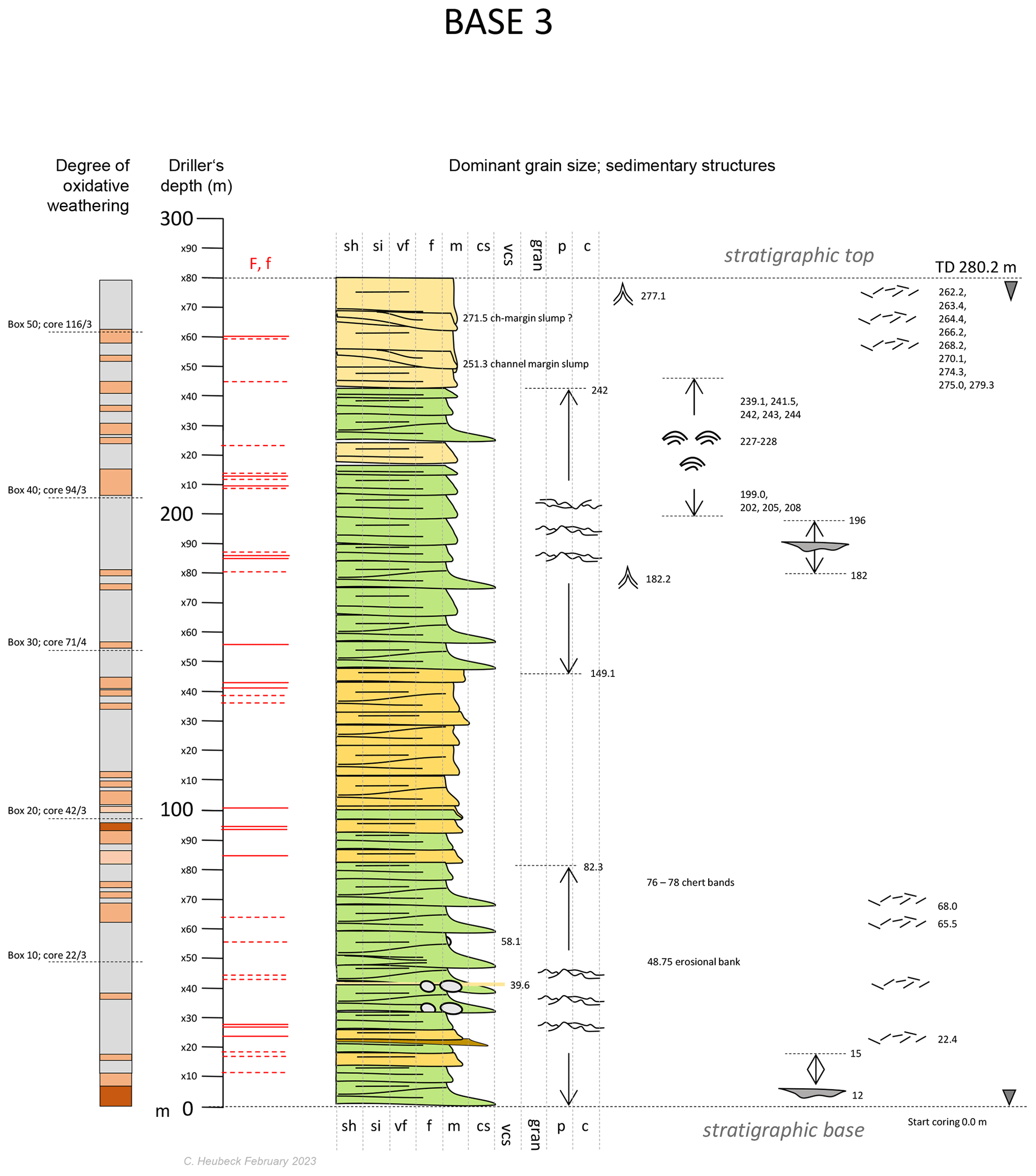
Figure 14BASE 3A drilled 319° from true north and base-up on the south-dipping southern limb of the NE–SW-trending Saddleback Syncline. The borehole spudded at 25°49′48.39′′ S, 31°5′26.88′′ E and was drilled from 25 November 2021 through 26 January 2022.
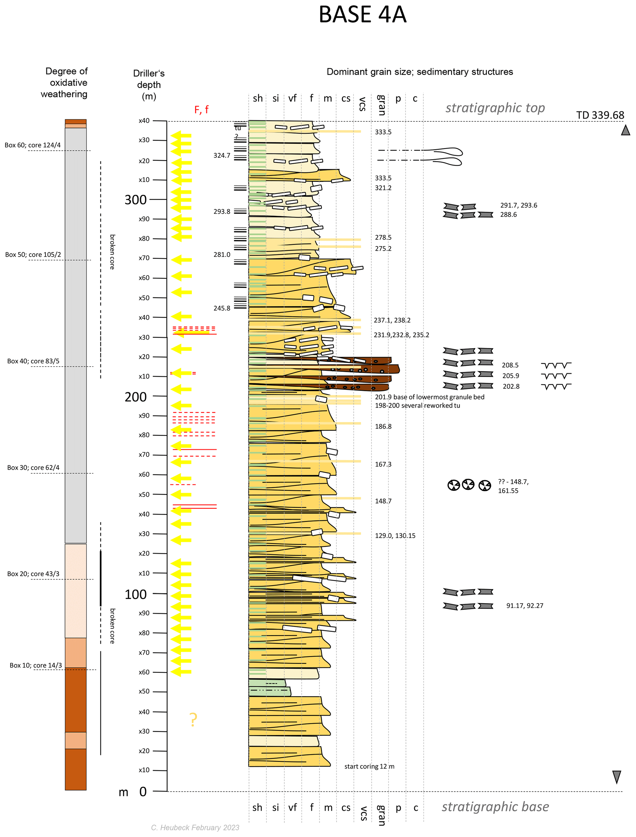
Figure 15BASE 4A drilled toward 319° from true north and base-up through the overturned southern limb of the Saddleback Syncline. The borehole spudded at 25°44′2.48′′ S, 31°5′51.08′′ E and was drilled from 17 November 2021 through 26 January 2022.
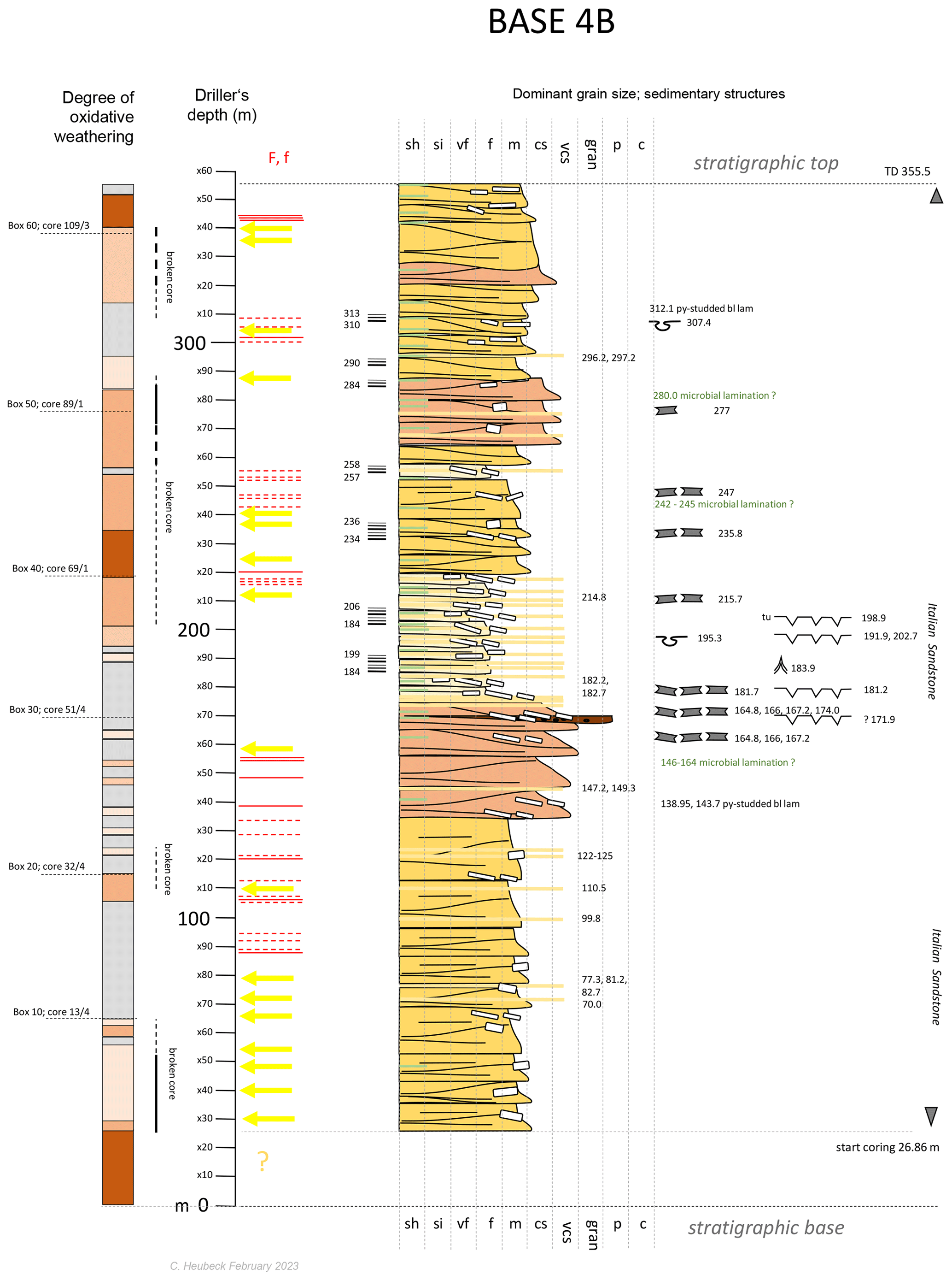
Figure 16BASE 4B drilled toward 336° from true north and base-up through the overturned southern limb of the Saddleback Syncline. The borehole spudded at 25°51′11.77′′ S, 31°2′54.81′′ E and was drilled from 9 February through 23 March 2022.
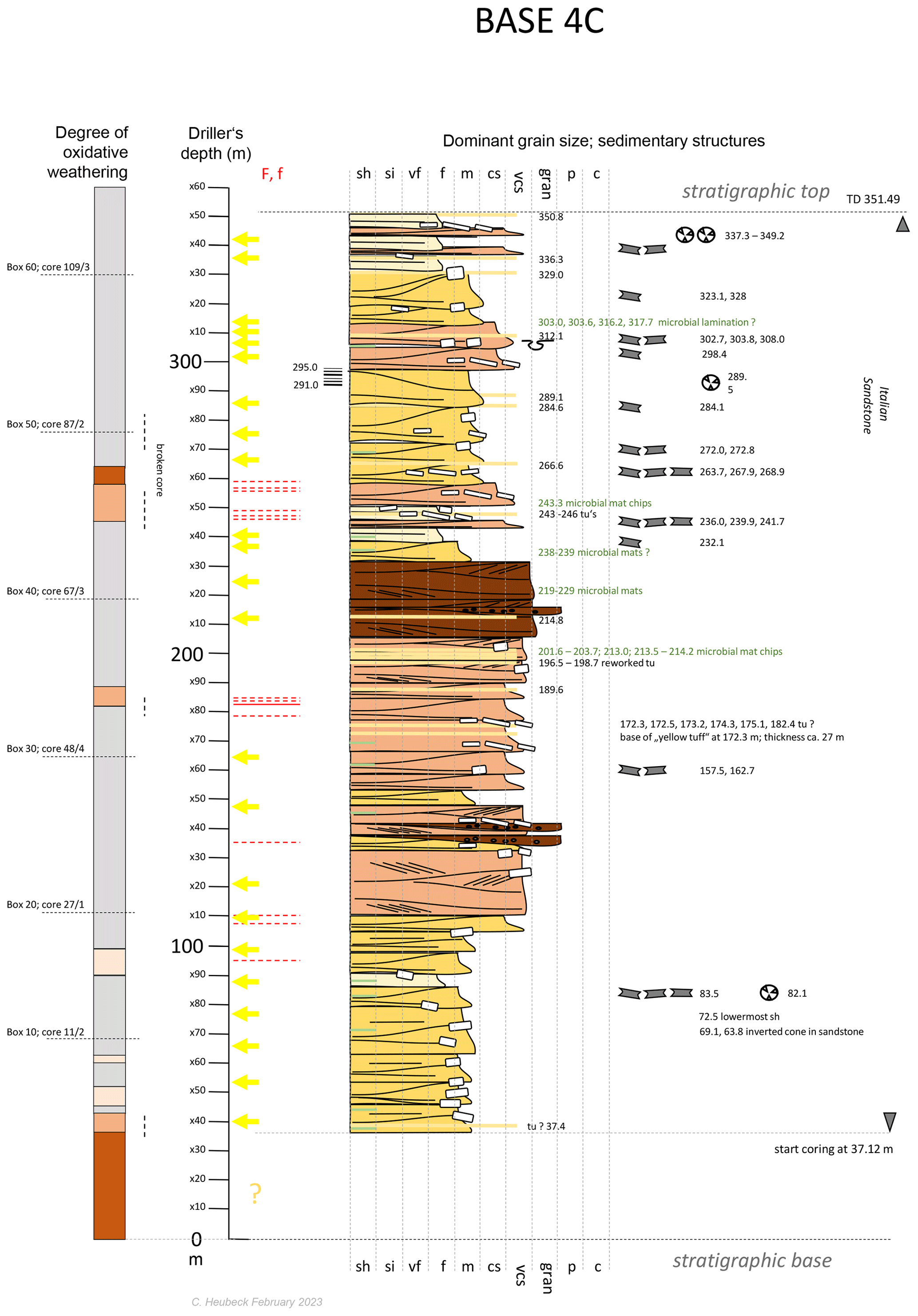
Figure 17BASE 4C drilled toward 336° from true north and base-up through the overturned southern limb of the Saddleback Syncline. The borehole spudded at 25°51′39.38′′ S, 31°2′3.41′′ E and was drilled from 11 February through 22 April 2022.
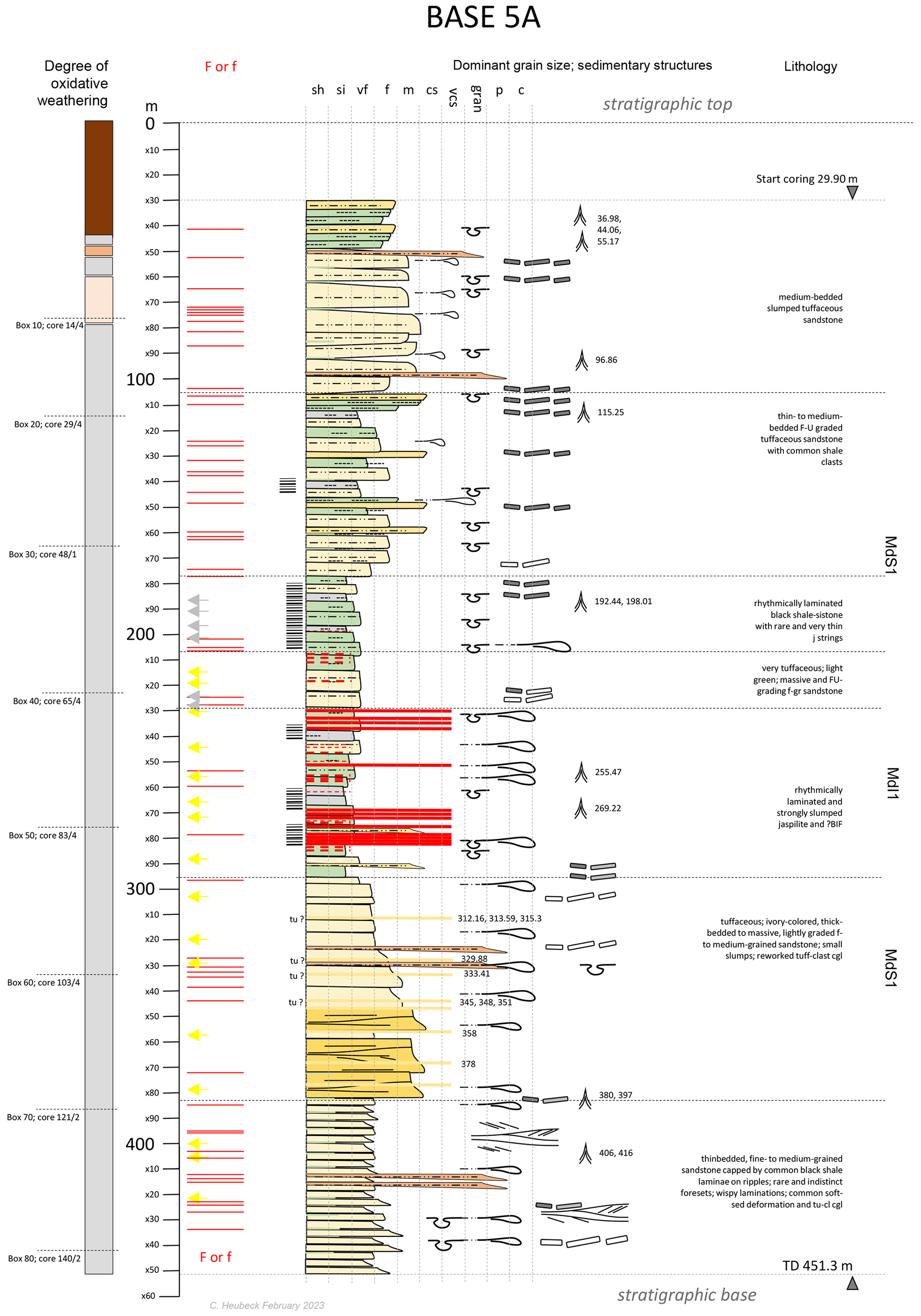
Figure 18BASE 5A drilled northward (009°) and top-down on the south-dipping northern limb of the E–W-trending Stolzburg Syncline. The borehole spudded at 25°54′13.32′′ S, 30°50′44.68′′ E and was drilled from 5 April through 18 May 2022.
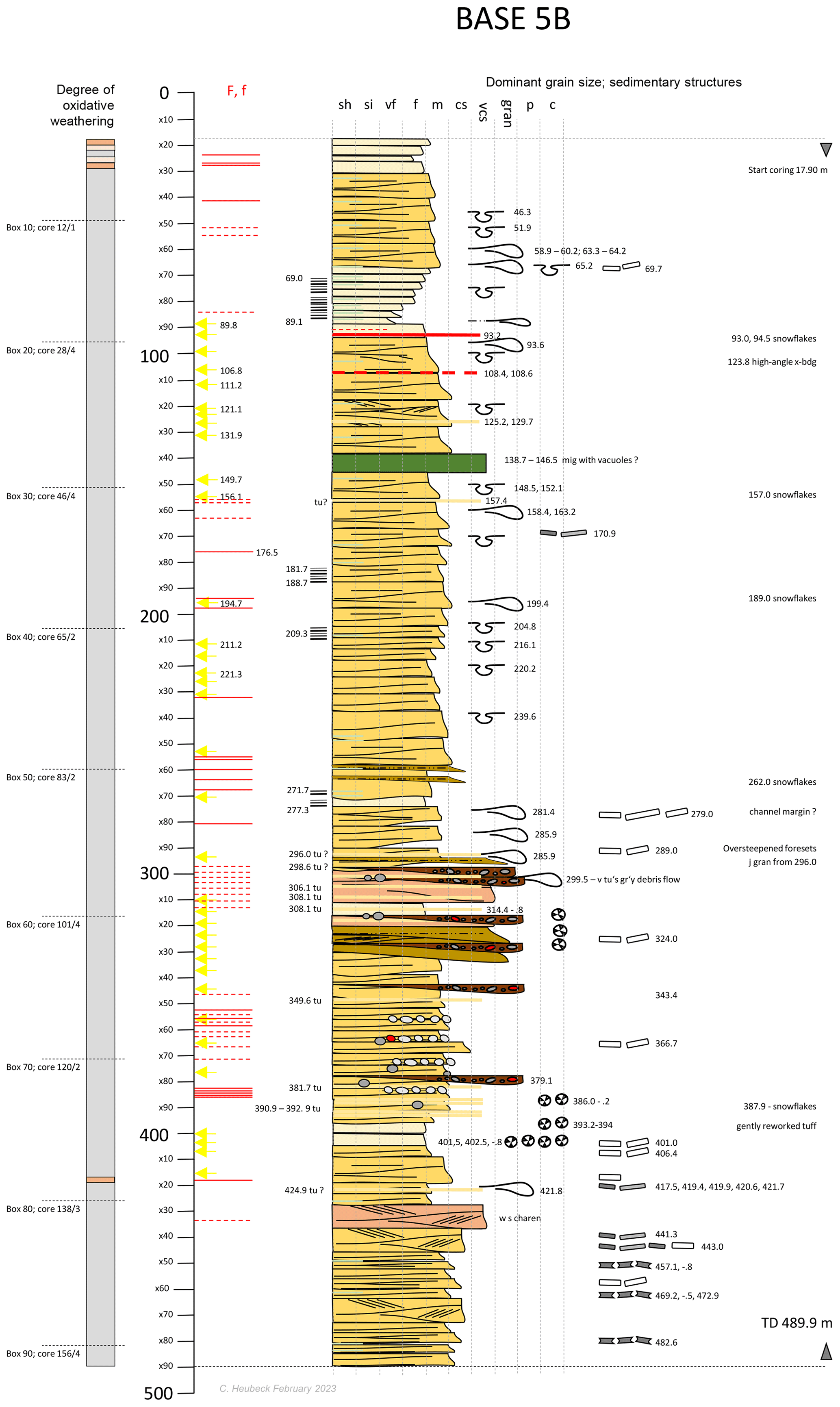
Figure 19BASE 5B drilled northward (013°) and top-down on the south-dipping northern limb of the E–W-trending Stolzburg Syncline. The borehole spudded at 25°54′2.80′′ S, 30°50′49.06′′ E and was drilled from 3 June through 17 July 2022.
The coring program encountered several surprises.
-
Unexposed strata overlying and underlying the weathering-resistant Lomati Delta Complex of the Saddleback Syncline in BASE 4A, BASE 4B, and BASE 4C did not consist of (deep-water) shale as predicted, but of friable, cross-bedded tuffaceous sandstones. This will require a reassessment of facies.
-
Virtually all boreholes encountered a high degree of fractured rock, resulting in excessive water consumption; oxidation along fractures was encountered up to 250 m depth.
-
The jaspilite unit MdI1 in the Stolzburg Syncline was found to be significantly thicker at depth than mapped at the surface (Luber, 2014) because finely interbedded shale-jaspilite was found to overlay and underlay the silica-rich central section.
-
BASE 2A encountered a thick association of cobble conglomerates interbedded with and reworking carbonaceous microbial mats, confirming the interpretations from nearby roadside outcrops (Heubeck et al., 2016) and supporting previous claims of continental, not entirely marine sedimentation.
-
BASE 3A, drilling a sandy tidal-flat facies (Homann et al., 2015), encountered repetitively stacked, ca. −20–90 cm thick, fining-upward genetic units. They consisted of microbial-chip conglomerate at the erosive base, overlain by massive sandstone, overlain by horizontally stratified and faintly microbially laminated sandstone, and capped by fully developed “crinkly” microbially laminated sandstone.
-
Virtually all boreholes encountered some felsic volcanic tuff (Heubeck et al., 2013, 2022b), but most are very thin and consisted of off-white fine-grained ash (not accretionary lapilli); most were slightly to fully reworked.
The preliminary stratigraphic columns of Figs. 12–20 provide a framework for lithologic and stratigraphic research. Fault zones, tuffs or tuffaceous horizons, and segments of abundant microbial mats or of well-developed laminations are marked. The locations of symbols representing sedimentary structures are approximate. On each log, a thin stratigraphic column qualitatively illustrates rock quality, thus indicating the extent of weathering near the surface and along fracture or fault zone networks.
7.2 Brief description of each borehole
Drill site BASE 1A was located in Elephant's Kloof valley on the grounds of Fairview Mine, ca. 10 km northeast of Barberton (25°44′2.63′′ S, 31°5′50.65′′ E). The borehole probed the overturned (inner) limb of the arcuate Eureka Syncline of the northern–central BGB. The drill site had to be moved from its originally planned location along a mine road due to space constraints to a stratigraphically lower position in a wide turnout of a hairpin turn. The hole was collared in altered schistose ultramafic rocks of the Weltevreden Formation of the Onverwacht Group in an anticlinal shear zone (locally known as the Zwartkoppie horizon of the Sheba Fault Zone). BASE 1A drilled, after having reached the faulted base of the Moodies Group at ca. 126 m depth, stratigraphically up-section. Drilling started on 19 May and ended on 27 July 2022, for a total depth of 496.85 m. The true stratigraphic thickness of cored Moodies strata is approximately 350 m.
This section targeted thick fine-grained siliciclastic strata of MdS1 and MdS2 in deep-water facies (delta slope turbidites of MdS1 and MdS2, offshore jaspilites and BIFs of MdI1 and MdI2). These units are also intermittently exposed in the Clutha Creek drainage ca. 4 km to the north (Christoph Heubeck, unpublished field notes) and along the slopes and ridges paralleling Elephant's Kloof valley. A second target was the progradational coarsening-upward or shallowing-upward sandstone complex of MdQ2, abruptly overlain by the regional Moodies basaltic lava (MdL2) and in turn overlain by jaspilites of unit MdI2 and fine-grained deep-water strata of MdS2. All targets were reached. The mine geologists examined all cores before they left Fairview Mine.
BASE 2A (25°47′37.78′′ S, 31°5′1.50′′ E) was located ca. 5 km from Barberton next to a parking lot of a geoscience stop (“Tidal Sandstones”) along the paved R40 route. This road, the “Geotrail”, winds its way across the central BGB from Barberton to the Josefsdal–Bulembu border post with Eswatini. The borehole targeted a retrogradational (deepening- and fining-upward) fluvial–coastal–estuarine section partially exposed on the northern, south-dipping limb of the Dycedale Syncline, described by Homann et al. (2018) and Heubeck et al. (2016). This site has spectacular outcrops in deeply eroded (“badland”-type) friable tuffaceous sandstones next to the parking lot on grassland slopes adjacent to the drill site and in good but weathered roadside outcrops north of the drill site; neither of these allows geochemical sampling. The borehole spudded on 3 February and reached total depth on 15 March 2022. It was drilled using a tracked rig on its first deployment and drilled for 367.80 m top-down. The true stratigraphic thickness of cored Moodies strata is approximately 290 m. This section was of great interest to the paleoenvironment, sedimentary, and life groups: from base to top, the units included fluvial sandstones with several intervals of microbial mats in channelized conglomerates (“life on land”; weathering rinds on clasts), coastal (lagoonal, sabkha) sandstones with abundant, partially rock-forming vadose-zone sulfate concretions (now largely silicified), interrupted by at least one Aridisol (terrestrial weathering) with teepee structures and a single andesitic lava flow (weathering intensity). These units are overlain by thick estuary sandstones (tidal dynamics) with significant tuffaceous contributions. Because key marker units known from outcrop (the top of the thick cobble conglomerate and the 1 m thick andesitic lava) were encountered ca. 40 m earlier than anticipated from the extrapolation of the surface dip angle, the post-drill cross section shows numerous out-of-syncline accommodation thrust faults. At least one such low-angle thrust fault is prominently visible in roadside outcrop.
BASE 2A was the most conspicuous and visited site of the drilling campaign; these aspects are described below.
BASE 3A (25°49′48.39′′ S, 31°5′26.88′′ E) was located on the north-facing rocky slope in the central Saddleback Syncline, stratigraphically at the top of unit MdQ1. The borehole had originally been planned ca. 200 m further uphill (further down-section), approximately on top of the ridge, but had to move downslope (up-section) to the wide dead end of a forest road on a steep rocky slope to occupy a suitable drilling location. From this “platform”, the rig drilled a 45° inclined borehole in young pine growth in the downslope direction. It spudded on 25 November 2021 and reached a total depth of 280.2 m on 26 January 2022, after having drilled base-to-top (up-section) through a thick low-relief tidal platform with abundant signs of microbial life. The true stratigraphic thickness of cored Moodies strata is approximately 218 m. The primary objective was to investigate stratigraphic patterns (rhythmicity, stacking) of microbial mats and their sandy host rock, to obtain continuous sections of microbial-mat-bearing sandstones and to investigate a thick tidal channel and a ca. 30 m thick unit of abundant calcareous “minimounds” resembling small stromatolites within the kerogenous-laminae-laced tidal sandstones (Heubeck et al., 2023).
All these objectives were reached. The borehole initially cored slightly gravelly sandstone of a coastal-plain facies (ca. 0–50 m) and then reached a sandstone unit (ca. 50–100 m) of numerous, stacked, ca. 0.2–0.7 m thick, fining-upward units consisting of (base-up) erosionally based microbial-chip conglomerate, massive sandstone, flat microbial mats, and tufted microbial mats. A cross-bedded sandstone unit ca. 50 m thick (100–149 m drilled depth) may represent an estuarine channel. The “minimound” unit, mapped in the eucalyptus plantation at the base of the slope, was encountered at ca. 199–239 m depth. The borehole surprised by its numerous fractures, many of them lined with oxidative halos.
Of all the BASE sites, this core offers the most detailed insight into how early life handled the challenges of exposure, tides, and abrasion. It is unique worldwide. This section is of central interest to the scientists interested in early life and paleoenvironmental conditions.
The three boreholes of Site BASE 4 (A, B, C) investigated the Lomati Delta Complex (LDC), a wedge-shaped coarse-clastic body extending over ca. 8 km strike length in the central Saddleback Syncline, by drilling one borehole each in its distal (BASE 4A), medial (BASE 4B), and proximal (BASE 4C) facies. The proximal part of this wedge, ca. 300 m thick, is well exposed as a prominent ridge in grasslands southwest of SAPPI plantations; the medial (ca. 150 m thick) and distal (ca. 12 m thick) segments are poorly exposed in extensive, mature pine and eucalyptus plantations occupying the wide Lomati Valley. The region is easily accessible by the Ameide Road, a major forestry road along the valley axis. The wedge, interpreted as an estuarine delta complex and named the LDC, was studied stratigraphically, sedimentologically, and petrographically by Laura Stutenbecker for her MSc (2014); the results were published in Stutenbecker et al. (2019). Microbial mats had been mapped in the distal and proximal outcrop sections, making this site an ideal candidate for investigating microbial life in a terrestrial–marine transition zone. The microbial mats in the distal location drilled by BASE 4A are probably erroneously identified in outcrop, but microbial mats were newly documented in BASE 4B and overlying outcrop. Their occurrence in the proximal outcrops was confirmed by BASE 4C. Approximately stratigraphically midway in the wedge-shaped units, a distinct thick yellow tuff provides a sound stratigraphic marker. Sedimentary structures (mud cracks, mudchip conglomerates, cross-bedding, mud coating on ripples, fluid-escape structures, etc.) abound in outcrop. Overlying and underlying unexposed and weathering-susceptible strata had been assumed to be shaly and to represent deep-water deposits, analogous to stratigraphically equivalent units in the Stolzburg and Eureka synclines. Preliminary assessment of the core, however, suggests that these strata represent highly tuffaceous, poorly cemented sandstones in estuarine facies. All three boreholes were drilled stratigraphically upwards (northwards to northwestwards) but physically downwards and at an angle of 45° through the overturned, ca. 70–75° southward-dipping, northward-younging strata on the > 3 km thick overturned limb of the Saddleback Syncline (Heubeck and Lowe, 1994a). Drilling in the fractured, tuffaceous, medium- to coarse-grained tuffaceous sandstones was accompanied by frequent loss of circulation. As a result, drilling parameters were occasionally not optimally adjusted. Long sections of the recovered core, particularly in the friable sandstones, show densely spaced drilling-induced stress fractures.
The three boreholes at Site 4 were expected to provide firm proximal-to-distal and marine-to-terrestrial correlations through a highly dynamic but systematic stratigraphic sequence of units to address the questions of microbial life in the transition zone (exposure to the atmosphere, radiation, resilience, metabolism) and basin dynamics (subsidence, sedimentation rates, tides, currents, paleogeography).
BASE 4A (25°49′52.60′′ S, 31°4′41.69′′ E) was the first borehole of the BASE drilling campaign. The rig arrived on site on 15 November 2021, and the borehole spudded 2 d later and reached a total depth of 340.1 m on 26 January 2022. The true stratigraphic thickness of cored Moodies strata is approximately 230 m. The rig had to overcome several difficulties: (1) the rig crew was initially inexperienced with the rock types and the operating parameters required to obtain high-quality core in friable sandstones; (2) the thickness of the fully weathered soil zone, assumed to be minor, was ca. 62 m thick; unweathered core was not reached until 125 m depth (ca. 90 m vertical depth); and (3) the summer rainy season was particularly intense. The borehole initially penetrated a seemingly monotonous sequence of medium-grained, tuffaceous, horizontal- and cross-bedded friable tuffaceous sandstones with thin shale coatings, carrying rare angular shale mud chips and common white tuff clasts and interbedded with numerous centimeter-thin (largely aqueously reworked) air-fall tuff beds. The distal equivalent of the LDC was encountered between 201.9 and ca. 219 m drilled depth. It is represented by a spectacular repetitive sequence of very-high-energy coarse-granule sandstone interbedded with shale–clast conglomerates and some (in-place) mud-cracked shale beds. In places (e.g., ca. 88–305 m), green shale laminae, white tuff clasts, and red jaspilite sand grains result in a colorful sandstone. Rhythmically bedded sandstone–(green) shale couplets on bedding planes and foresets are common.
BASE 4B (25°51′11.70′′ S, 31°2′54.70′′ E) was set up at the junction of several secondary forest roads just upslope of (and stratigraphically below) a prominent forested ridge, ca. 1670 m downdip from BASE 4C and ca. 3820 m updip from BASE 4A. Drilling started on 9 February 2022 and ended at 355.5 m depth on 23 March 2022. The true stratigraphic thickness of cored Moodies strata in the borehole is approximately 300 m. Drilling progress was good through evenly firm rock at ca. 10 to 15 m d−1. The borehole started coring after leaving the zone of profound weathering at 27 m. It penetrated a lithologically similar sequence to BASE 4A. The high-energy, very-coarse-grained and mudchip-carrying units extended over ca. 150 m thickness (ca. 135–284 m), with several indications of (reworked?) microbial laminations. A highly tuffaceous unit, approximately midway in the target unit, occurred between 175 and 219 m depth. Rhythmic (tidal?) bedding was commonly encountered. The quality of the core was affected by extensive oxidative alteration and fracturing between 188 and 288 m and from 315 to 350 m depth. The reasons for this alteration at significant vertical depth are unknown; possibly, these are expressions of a wide alteration zone associated with a brittle shear zone along Lomati Valley, of vertical fractures extending to this depth, or of a hydrothermal halo surrounding a porphyritic mafic dike mapped ca. 50 m beyond the location of the end of the borehole in an unusual, approximately bedding-parallel orientation. Also, the core shows several zones of an unusual, evenly dark-grey discoloration (e.g., 151–176 m).
The drill site for BASE 4C (25°51′39.40′′ S, 31°2′3.11′′ E) was originally intended to be located in grasslands just outside (southwest of) the SAPPI plantation in order to obtain the best possible correlation with well-exposed sandstone ridges of the proximal-facies LDC; however, the site was moved a few tens of meters to the northeast to be located just within SAPPI property on recently harvested pine plantation land. This was decided to keep environmental disturbance to a minimum and to avoid the necessity of negotiations with the owner MTPA, a provincial state agency. The plantation stands on the ridge in that section had been recently harvested, so that rock exposures were excellent and ubiquitous. Drilling took place from 11 February through 22 April 2022 and reached 351.49 m depth. The true stratigraphic thickness of cored Moodies strata is approximately 295 m. The rock quality was generally good. The base of the LDC was reached at ca. 105 m; its top is gradational fining-upward and was not encountered in the core. Key correlative units are as follows: (1) base of yellow tuff, ca. 25 m thick, at ca. 172 m; (2) microbial mats, ca. 10 m thick, ca. 5 m above the top of the yellow tuff; (3) base of the mud-crack-bearing unit, ca. 10–30 m above the top of microbial mats. Concretions were recorded between 337 and 349 m.
Site BASE 5 (A, B) cored top-down a ca. 860 m thick section; this required two offset boreholes in which the bottom of BASE 5A correlated with the top of BASE 5B. It targeted a conformable deepening-upward (transgressive) sequence top in the eastern Stolzburg Syncline from a fluvial–evaporitic floodplain at the stratigraphic base to a prodelta facies at the stratigraphic top (Luber, 2014). The site was chosen to be located approximately midway between a major, obliquely crosscutting dolerite dike to the west and the tight curvature encountered in the fold hinge of the Stolzburg Syncline in the east; it also attempted to avoid mapped faults of minor offset and relied on good but weathered and intermittent surface outcrop for stratigraphic and structural control. The true stratigraphic thickness of cored Moodies strata, combined from both boreholes, is approximately 740 m. The stratigraphic base of BASE 5A overlaps the cored stratigraphic top of BASE 5B by about 20 m (cf. Fig. 28).
BASE 5A (25°54′13.97′′ S, 30°50′44.83′′ E) spudded on 5 April 2022 and reached its TD of 451.3 m on 18 May. It started coring at 30 m depth. Basal strata probably overlap with those at the top of BASE 5B by about 20 m and represent rhythmically bedded tuffaceous and shaly (green) fine-grained sandstones with common slump, dewatering, and load structures. This is indicative of high rates of deposition, largely below wave base (451–385 m) in a distal delta mouth bar and upper-prodelta setting. A minor sandy delta lobe was intersected between ca. 385 m (base) and 320 m (top). Lower-slope prodelta sedimentation style dominates the remaining, overlying section (ca. 320–30 m core depth). Spectacular intervals of rhythmically bedded (e.g., 180–206 m) and slumped, micro-laminated BIF, jaspilite, and shale occur between 230 and 290 m. The ferruginous section, stratigraphically known as MdI1, was significantly thicker than predicted from its surface exposure of 10 to 15 m; it correlates lithostratigraphically with a jaspilitic interval mapped as MdI1 near 180 m depth in BASE 1A, more than 31 km to the northeast. The interval 175–295 m (MdS1) probably represents the finest-grained, deepest-water, most distal facies encountered during the BASE drilling program, alongside a similarly fine-grained section in BASE 1A at 160–270 m depth. The true stratigraphic thickness of cored Moodies strata in BASE 5A was approximately 360 m.
BASE 5B (25°54′2.80′′ S, 30°50′49.06′′ E) started drilling on 3 June 2022 and terminated at 489.9 m depth on 17 July 2022. Coring started at 17.9 m depth. The section (base to top) begins in tuffaceous, cross-bedded, slightly gravelly floodplain sandstones with common early-diagenetic silicified sulfate concretions (ca. 500–350 m depth), probably representing vadose-zone diagenesis of sulfate-bearing tuffaceous sediments. They contain evidence of microbial sulfate reduction (“life on land”, Nabhan et al., 2016b). This zone is overlain by coarse-sandy and gravelly shoreline-facies sandstones, ca. 350 to 300 m, possibly interrupted by lagoonal sediments consisting of reworked tuffaceous (lapilli) siltstones (ca. 315–306 m). Overlying thick, green, monotonous medium-grained tuffaceous sandstones with common load structures may represent shoreline and upper delta mouth bar facies with extensive reworking, slumps, load structures, and shale-free foresets (ca. 306–100 m), gradually grading into finer-grained sandstones with some rhythmically bedded segments (150–18 m). Thin shaly jaspilites were encountered at 108 and 93 m depth, the latter reworked as chip clasts. Microbial mat sandstones were not encountered in either core. The section is generally rich in tuffaceous material. The true stratigraphic thickness of cored Moodies strata was approximately 400 m.
7.3 The tunnel sections
Three tunnels which traverse relevant Moodies strata in the central BGB at approximately right angles to strike were made accessible for sampling. They were (1) the Lomati water tunnel below Saddleback Hill of the Saddleback Syncline, ca. 2 km south of Barberton (van Wyk, 1985); and (2) the Ben Lomond (a.k.a. Princeton) and 22-level adits of Agnes Mine in the Moodies Hills Block, ca. 8 km west of Barberton. The data obtained from those tunnels add significantly to the stratigraphic extent of unweathered Moodies samples and can easily be integrated into BASE data. We include a basic description of this data set in the operational report. A more detailed description was the topic of two BSc theses completed in 2023 at the University of Jena under the supervision of Christoph Heubeck (Seifert, 2023; Bender, 2023). Visual inspection and point counting of medium-grained sandstones show that samples from all three tunnels are fresher than virtually all surface outcrop samples above the tunnels. Samples were relabeled, photographed, packed, and shipped to the Department of Geosciences, FSU Jena.
7.4 Description of BASE basic data sets
7.4.1 Data sets originating from drilling operations
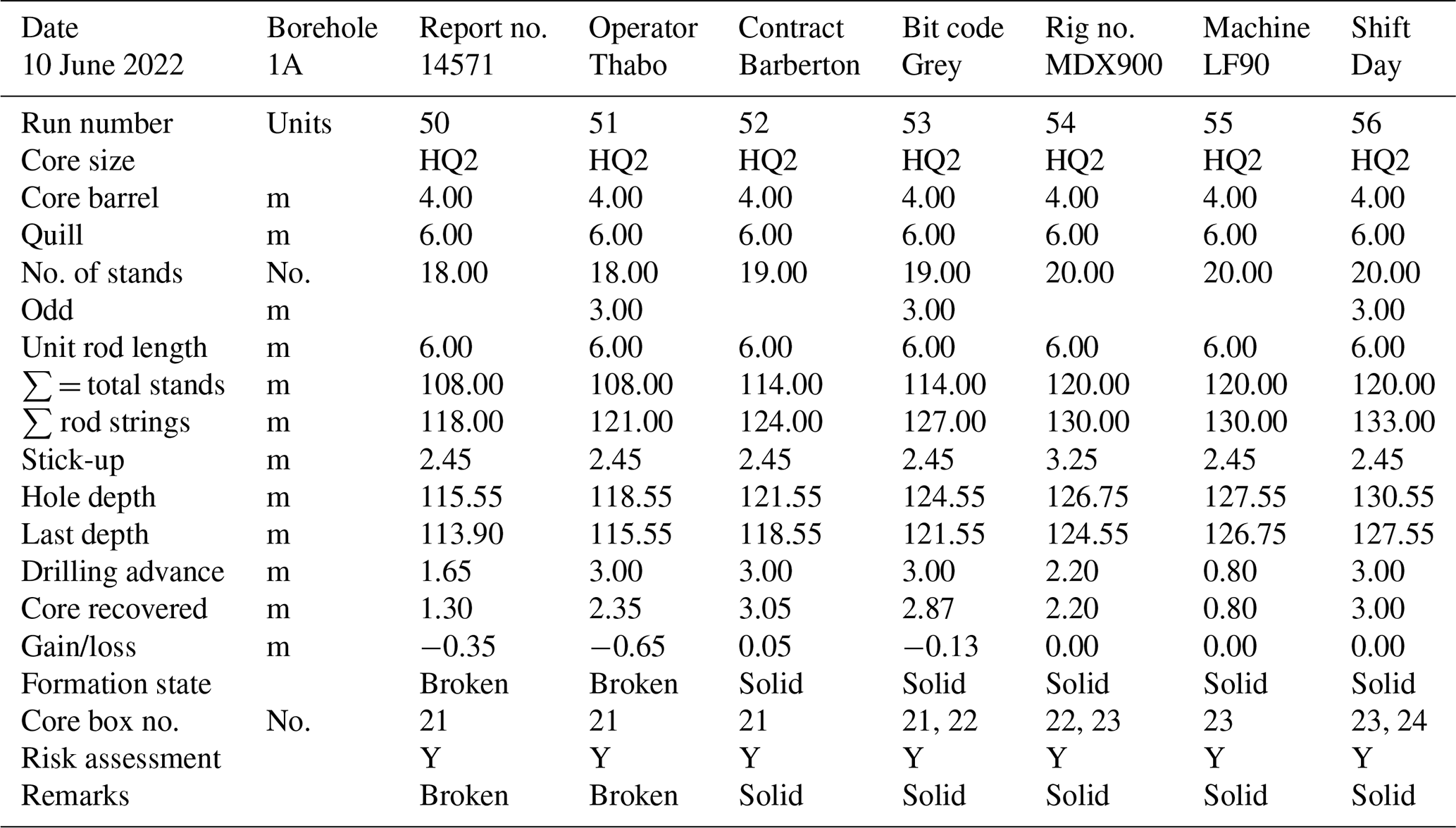
Table 4 shows an example of the daily Driller's Report.
7.4.2 Data sets based on the drill core
All basic data sets generated during drilling up to the end of the second sampling workshop in March 2024 are compiled, described, and curated following ICDP conventions (operational report in Heubeck et al., 2024a; data sets in Heubeck et al., 2024b; explanatory remarks to the data sets in Heubeck et al., 2024c). The basic data sets are available at https://doi.org/10.5880/ICDP.5069.001 (Heubeck et al., 2024b). International Generic Sample Numbers (IGSNs) were assigned to all the holes, cores, sections, and samples and will be registered. After the expiry of the moratorium on 15 September 2025, 2 years after the end of the first sampling workshop, all the data sets and IGSNs will become publicly available.
Photography
BASE photographs are organized by borehole and then by core tray. All full (unslabbed) cores in their trays were photographed in wet and dry states unless the core was too crumbly. Similarly, all working halves and archive halves of the slabbed core were photographed wet and dry, with a few exceptions. Each photograph also shows a data bar at its base (Fig. 21).
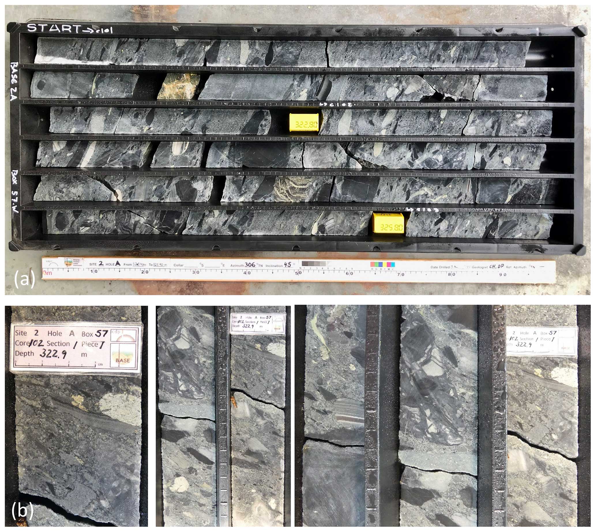
Figure 21Examples of core photographs. (a) Slabbed and wet core of box 57 of borehole BASE 2A, showing ca. 2.5 m of core 101, all 3 m of core 102, and 0.4 m of core 103. The stratigraphic top is to the upper left. The data bar provides information about the depth, date, and staff. (b) Examples of handheld close-up photographs of the same core tray, showing textures of the cobble conglomerate and composition of individual clasts, mostly latite (“feldspar porphyries”) and chert.
At the Spandau core facility, most core trays (containing five core sections of approximately 1 m each) of BASE 5A, BASE 2A, and BASE 3A were scanned using a DMT core scanner to preserve their sedimentary textures in detail. This generated high-resolution (11 000 × 4000 px; ca. 160 MB) images, which allows 1 : 1-scale printouts of the images without pixelation.
Lithology and structures: conventions, depth, and lithologic description
Core naming conventions followed ICDP protocol (Expedition – Site-Hole – Core – Section – Split – Lithology/Facies Units/Special Geol. Features/Sample).
| Expedition | Project name, expedition no. | BASE, 5069 |
| Site | One or more boreholes in a specific area | 4 |
| Hole | Borehole number | A, B, C |
| Run | Drilling run number | Run with the core barrel |
| Core | A single piece of drill core retrieved from the | |
| run (up to 3 m length) | ||
| Section | A row of core in a core tray or box (up to 1 m | |
| length) | ||
| Split | A: archive half (to Pretoria) | |
| W: working half (to Berlin) | ||
| Advance | Run start less run end (hole depths) | |
| Recovery | Length of core recovered in a run | |
| Gain/loss | Advance − recovery | |
| Depth | Drill hole depth below the reference base plate | |
All depths represent handwritten marked depths (by the Onsite Geoscience Team) on the core, not the drillers' depths marked on the yellow or green plastic blocks. These drillers' depths usually only deviate by centimeters to several decimeters from measured and marked core depths. We used and accepted drillers depths, however, where there was core loss or bad ground. We found that the drillers' depth and the measured depth were balanced within a few decimeters at the end of each borehole, after 280 to 498 m of drilling. Lithologic descriptions were entered into the mDIS using the predefined sets of labels described above.
7.4.3 Data sets based on downhole logging
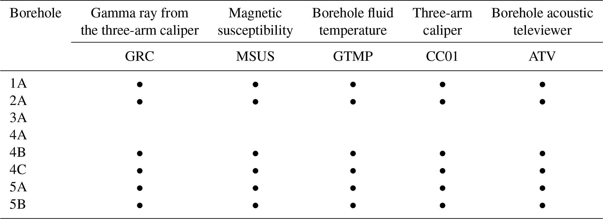
All boreholes were geophysically surveyed (log depth, true depth, hole tilt and azimuth, axial and polar coordinates) to check for agreement with planned azimuth and inclination. We initially intended to do most geophysical logging (GR, magnetic susceptibility) on the core and thus did not log the first two boreholes BASE 4A and BASE 3A, except for surveying. We soon realized, however, that this approach was erroneous because the fractured and broken core in core trays would have made laboratory logging difficult or impossible. All subsequent boreholes (BASE 1A, BASE 2A, BASE 4B, BASE 4C, BASE 5A, BASE 5B) were therefore logged with GR, magnetic susceptibility, temperature, caliper, and a borehole acoustic televiewer (ATV) (Tables 5, 6). ATV logging provided continuous, high-resolution ultrasound images of the borehole wall for detection and characterization of fracture-network and geologic characterization. Porosity and resistivity logs were not run because they did not contribute recognizably to the objectives of the drilling campaign. The geophysical contractor, Wireline Africa, provided log data in raw and processed format.
7.4.4 Geochemical reference data set
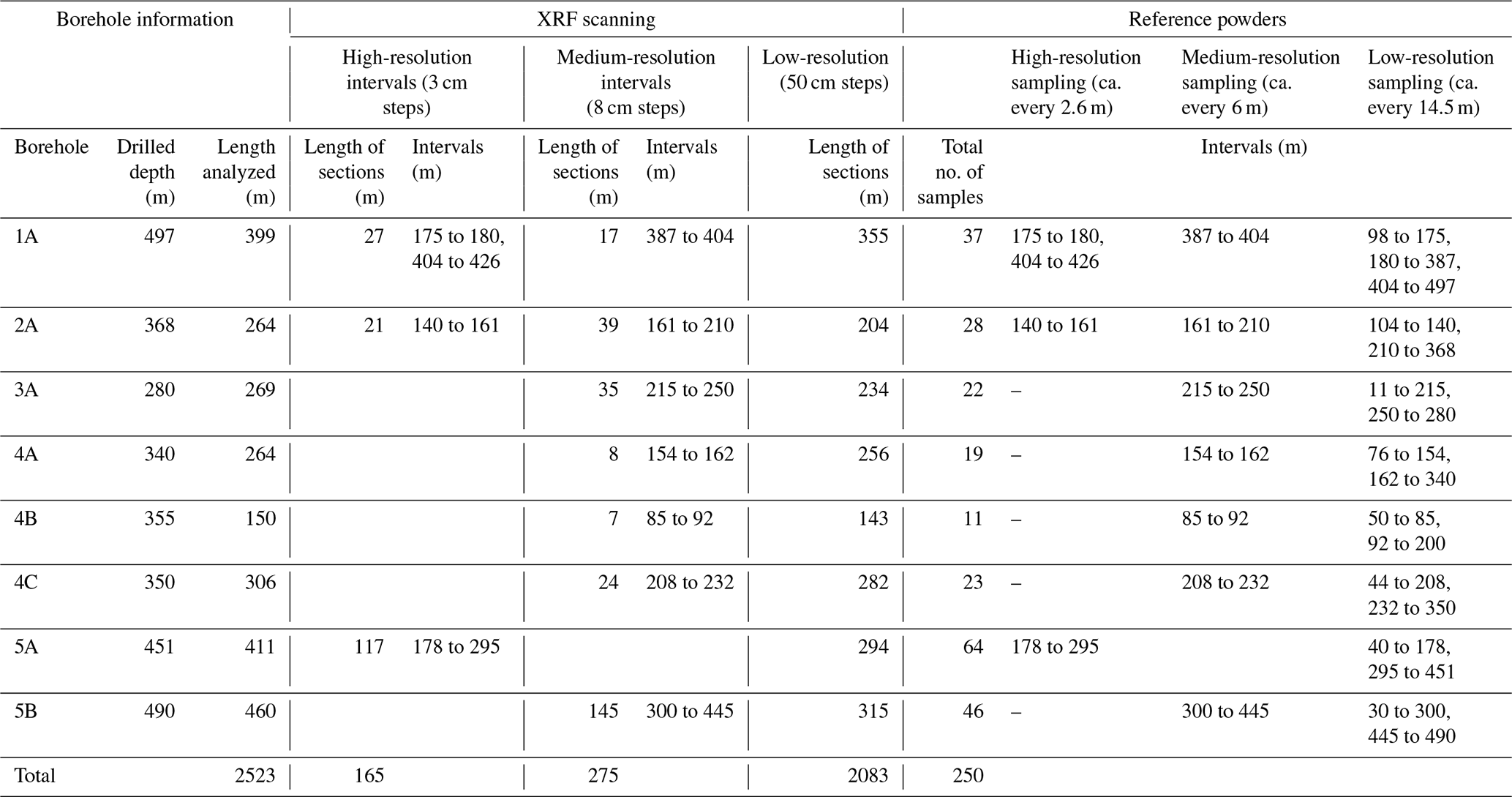
All working halves were sampled in January and February 2023 at the BGR core repository in Berlin, Germany, to construct a combined geochemical reference data set composed of major elements, trace elements, and mineralogy using X-ray fluorescence (XRF) scanning (Spandau, Brest), XRF bulk rock fusion disk analysis (Utrecht), and X-ray diffraction (XRD) on pressed powder pellets (Paris), respectively (Table 7).
Table 7Locations of the samples and intervals taken for the geochemical reference data set.
A brief description of each method follows.
-
All cores were scanned using the Avaatech core scanner at the BGR core repository in Spandau. This instrument records characteristic X-ray spectra of a ca. 1 cm2 sized area for elemental composition. Core samples were therefore selected about 1 m apart (i.e., about one sample per core box groove or approximately five samples per tray) and sequentially arranged in the instrument tray. In regions of medium interest, scanning was done in steps of 5 to 10 cm and, in the zones of highest interest, in steps as low as 3 cm. Measurements took about 6 weeks of full-time work. Table 7 shows the chosen intervals of high, normal, and low sampling density.
-
At the same facility, core was (destructively) sampled for powdering and bulk rock geochemical analysis. Segments ca. 10 cm long were selected approximately every 5 m (i.e., approximately one sample per core box) and slabbed in half, cutting parallel to the core long axis using a core saw. The unused half of the slab (a quarter core) was returned to the core tray. Selected samples were crushed and powdered by two technicians at Brest in April 2023. Because the powders were more voluminous than anticipated, aliquots of the reference set and some remaining rock chips from the saw cut are available upon request from Stefan Lalonde (Brest) and Paul Mason (Utrecht). Amandine Migeon processed the pressed powders for high-precision whole-rock trace-element analysis by high-resolution inductively coupled plasma mass spectrometry (HR-ICP-MS).
-
Whole-rock powders were analyzed at Utrecht University for major elements by XRF. Wavelength-dispersive XRF measurements for major elements were carried out sequentially using a Thermo Scientific ARL Perform'X 4200W. Loss on ignition (LOI) was measured by thermogravimetric analysis at 1000 °C. Fusion beads were prepared using 0.6 g sample and 6 g flux consisting of 66 % lithium tetraborate, 34 % lithium metaborate, and 0.5 % lithium iodide.
-
Stefan Lalonde wrote MATLAB code to plot large numbers of core-scan XRF data points usable for custom plots, e.g., for choosing a core interval to plot geochemical profiles as high-quality Adobe Illustrator-editable PDF files.
-
Powders were analyzed for quantitative mineralogy by X-ray diffraction at the Museum d'Histoire Naturelle in Paris in May and June 2023.
7.4.5 Borehole and wellsite documentation
Pre- and post-drill geologic cross sections
Detailed geologic maps of the regions around the drill site had provided the basis for predictive cross sections which were updated and annotated as drilling progressed. Their principal purpose was to check the progress in reaching borehole objectives by correlating the stratigraphic sequence encountered in the borehole with surface geology. Once total depth was reached, final cross sections were prepared (Figs. 22–28).
The final borehole sections generally differ from the predictive boreholes by showing (usually unexpectedly thick) weathering zones and much greater stratigraphic detail. They do not contain major inconsistencies, except at BASE 2A, where the top of the conglomerate was encountered about 30 m earlier than predicted from outcrop data. This offset was interpreted in the BASE 2A post-drill cross section by postulating a series of nearly horizontal, out-of-syncline accommodation faults, each with a minor offset. At least one such fault is well documented in roadside outcrop north of the drill site (cf. Heubeck et al., 2016; their Fig. 7).
Stratigraphic logs
The overview lithostratigraphic logs (Figs. 12–20) are based on the evaluation of core tray and close-up photographs. The scale of each log is such that the entire log occupies a single A3-sized printed page; the vertical resolution is thus approximately 2 m. Thinner units are not or only selectively represented. Because five of the eight BASE boreholes were drilled stratigraphically upwards (base to top), the depth scale increases upwards on these logs, so that the stratigraphic column can be displayed in the correct (youngest unit on top) orientation.
Hyperspectral data set
The three-camera hyperspectral scanner at the Donkerhoek National Core Storage Facility was used to image the complete core in 2023. The RGB camera provides natural color images at high spatial resolution, while the spectral cameras provide mineralogical information in the visible near-infrared (VNIR), shortwave infrared (SWIR), and longwave infrared (LWIR) electromagnetic spectra. We are currently trying to make this data set accessible from the BASE ICDP webpage.
7.4.6 Subsequent analyses
A first sampling workshop was conducted at the BGR core repository facilities in Berlin–Spandau from 11 to 14 September 2023; it was attended by 41 scientists. Ample space and favorable weather allowed us to lay out all 503 core boxes in the spacious parking lot. This made for efficient and convenient sampling on the following days. About 1100 samples were taken. Documentation for internal use was placed on the BASE ICDP webpages. For each sample an IGSN was automatically generated in the mDIS and also printed on the sample label. All IGSNs for holes, cores, splits, and samples will be registered and publicly available after the moratorium period has ended.
The project ended slightly under budget because the education–outreach–publicity activities had been lower than estimated and because no borehole had drilled beyond 500 m. Drilling took about 9 instead of the estimated 6 months because of frequent rig breakdowns in the first 6 weeks of operations and weather-related delays during an unusually wet summer rainy season. The primary objective, to obtain a significant length of continuous and unweathered core through sections of siliciclastic sedimentary facies changes and pertaining to the surface conditions of early Earth, was fully reached. Surficial weathering reached deeper, and fracturing of the rock was higher than predicted. Initial inspection of core and logs does not show evidence of major deviations from predictions but rather confirms and clarifies several assumptions. The project had a high and lasting societal impact.
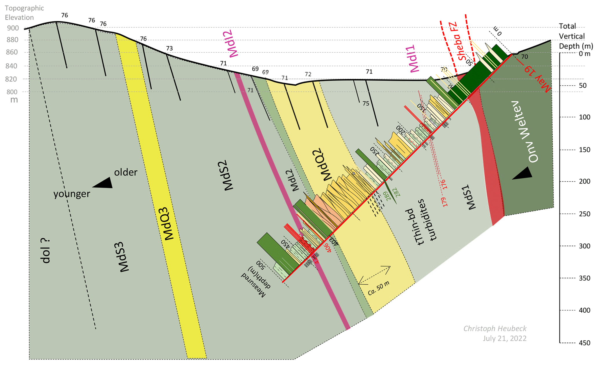
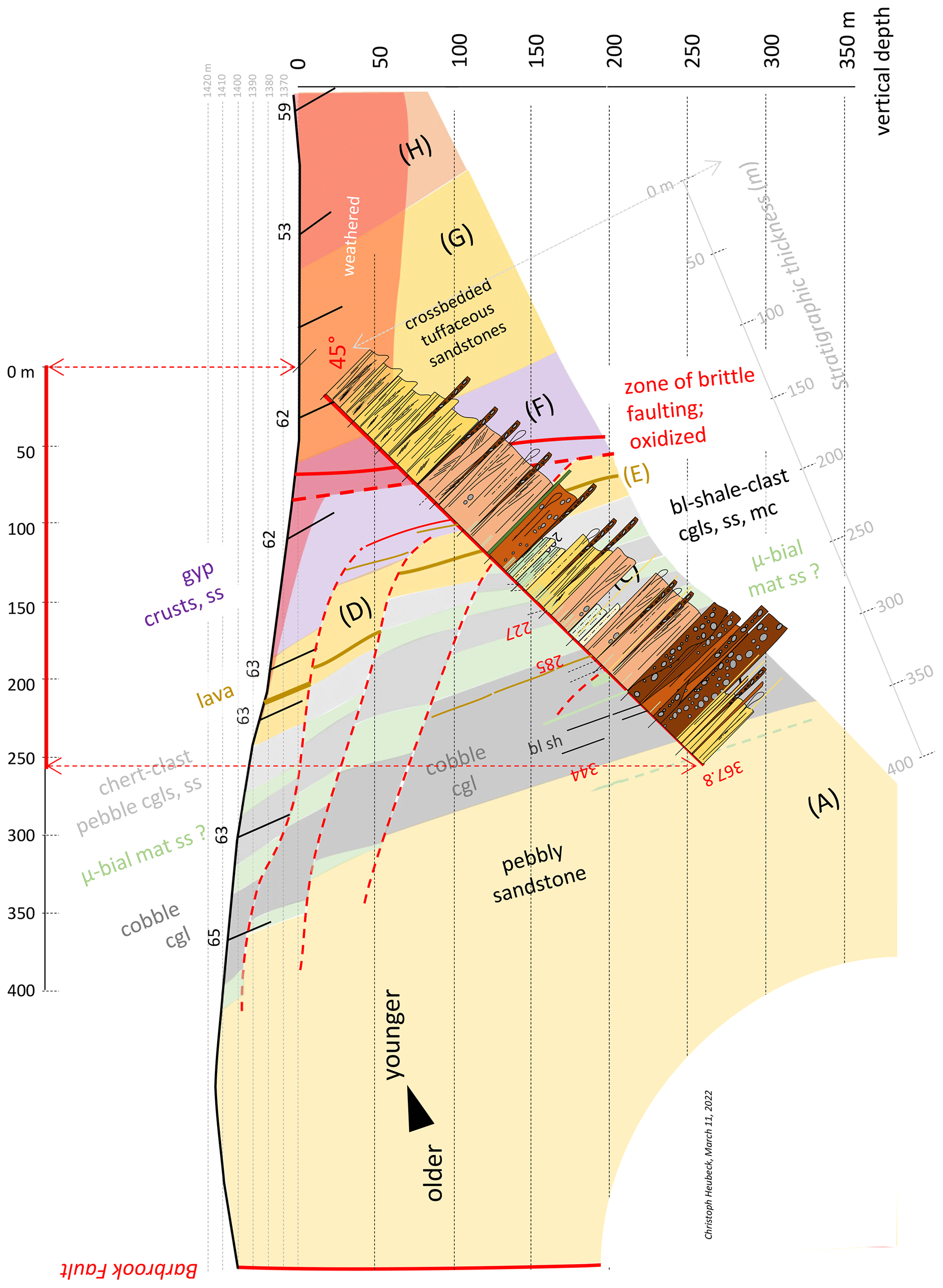
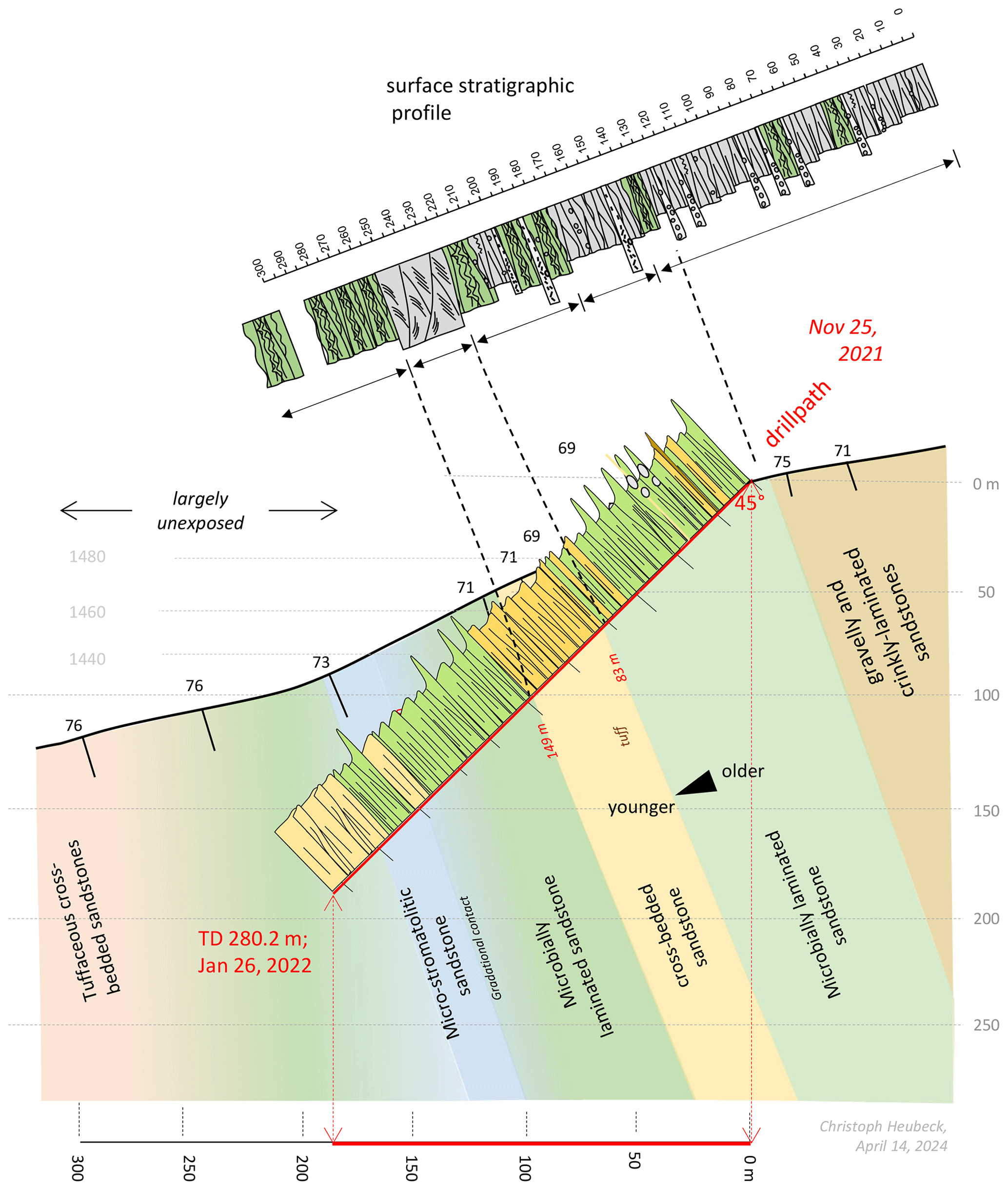
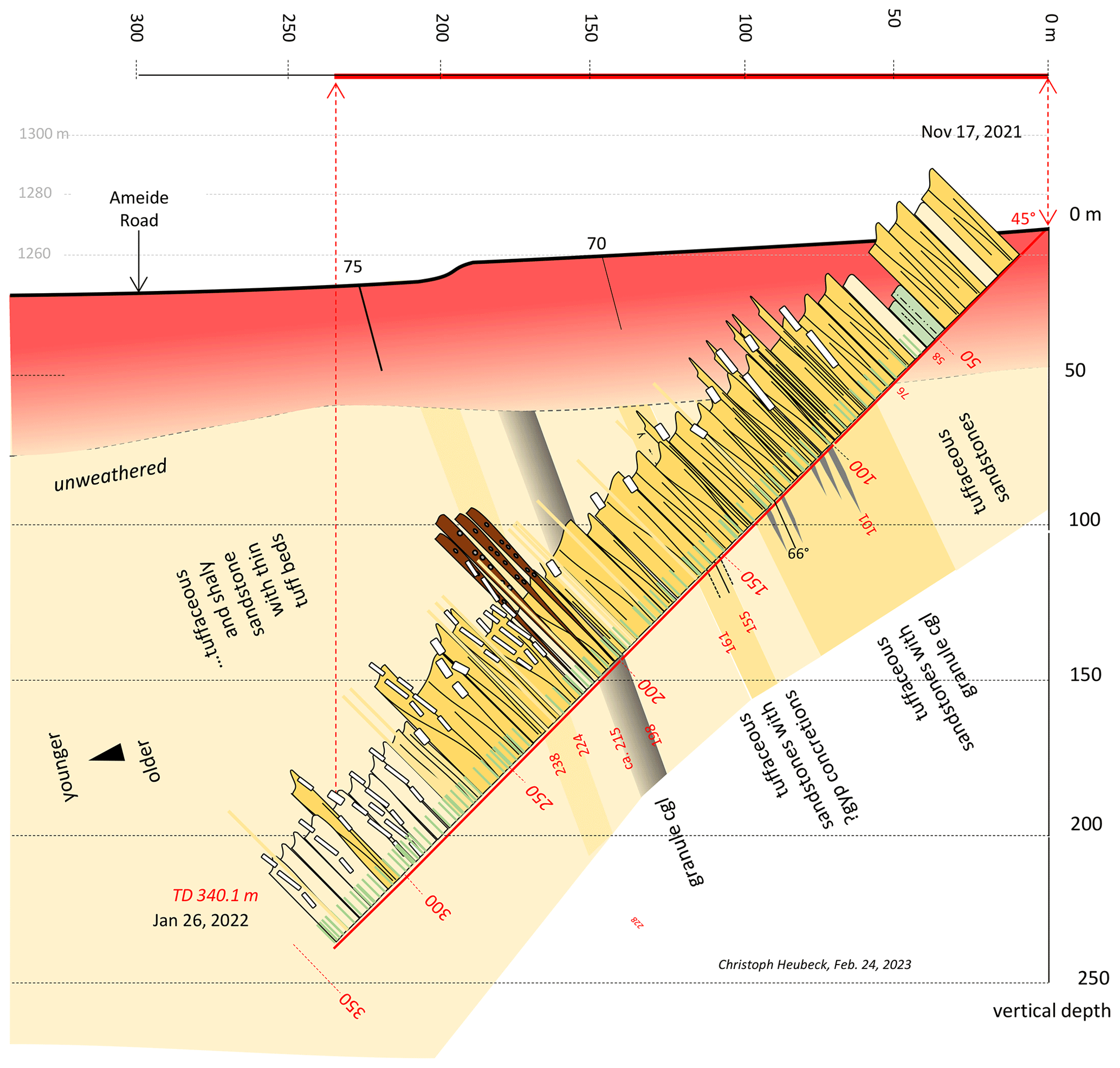
Figure 25Post-drill geological cross section of Site 4A (distal Lomati Delta Complex, Saddleback Syncline).
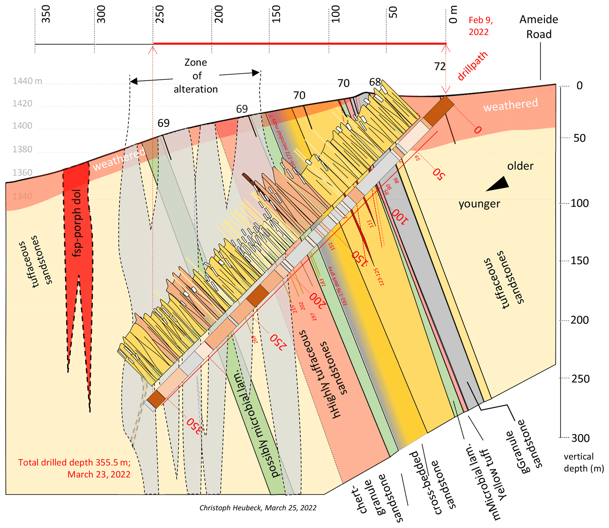
Figure 26Post-drill geological cross section of Site 4B (medial Lomati Delta Complex, Saddleback Syncline).
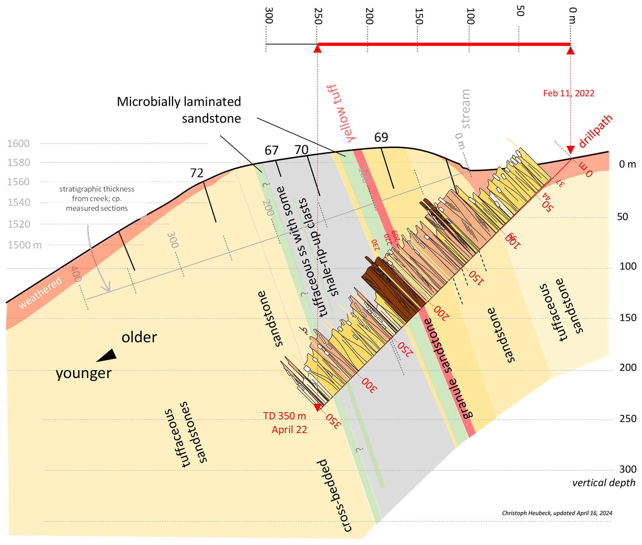
Figure 27Post-drill geological cross section of Site 4C (proximal Lomati Delta Complex, Saddleback Syncline).

| AI | Artificial intelligence |
| BARB | Barberton Drilling Project |
| BASE | Barberton Archean Surface Environments |
| BGB | Barberton Greenstone Belt |
| BIAS | Barberton Iron and Steel |
| BIF | Banded-iron formation |
| CGS | Council for Geoscience (South Africa's national geologic survey) |
| CIMERA | Centre of Excellence for Integrated Mineral and Energy Resource Analysis |
| DSI-NRF | Department of Science and Innovation, National Research Foundation |
| ECO | Ecological Control Officer |
| EOP | Education–outreach–publicity |
| FSU Jena | Friedrich-Schiller-Universität Jena |
| GR | Gamma ray |
| GSSA | Geological Society of South Africa |
| HSE | Health, safety, and environment |
| ICDP | International Continental Scientific Drilling Program |
| IGSN | International Generic Sample Number |
| KLCBT | Kruger Lowveld Chamber of Business and Tourism |
| LDC | Lomati Delta Complex |
| MTPA | Mpumalanga Tourism and Parks Agency |
| mDIS | mobile Drilling Information System |
| PI | Principal investigator |
| ROP | Rate of penetration |
| SRU | Solid Removal Unit |
| TUT | Tshwane University of Technology |
| UJ | University of Johannesburg |
The DALL-E generative AI software, incorporated into Microsoft's Bing Internet browser (https://www.bing.com/images/create, Microsoft Inc, 2023a) or accessible through https://openai.com/index/dall-e-2/ (Microsoft Inc, 2023b), was used to generate the images of Fig. 1. This Scientific Report refers to Heubeck et al. (2024a, b, c). The data set is available at https://doi.org/10.5880/ICDP.5069.001 (Heubeck et al., 2024b).
The authors are either members of the BASE Science Management Board or contributed substantially to core processing during drilling operations. CH conceptualized the drilling program, supervised operations, wrote the original draft, and visualized the results. CH, NB, EJJ, TK, PaM, and MT acquired funds. MH, CH, EJJ, TK, SL, PaM, and MT contributed investigation methods and concepts. NB, CH, and AC contributed resources. NB was the project's administrative leader, assisted by PhM, CH, MdK, and AC. MdK, VN, PaM, MT, EJJ, MH, CH, and CK reviewed and edited the manuscript, and CH and CK curated and validated voluminous data. CH, PhM, DP, CR, RoT, RyT, and VN processed the core.
The contact author has declared that none of the authors has any competing interests.
Publisher’s note: Copernicus Publications remains neutral with regard to jurisdictional claims made in the text, published maps, institutional affiliations, or any other geographical representation in this paper. While Copernicus Publications makes every effort to include appropriate place names, the final responsibility lies with the authors.
We enthusiastically thank the ICDP Operations Support Group for continued help and advice through speedy advice, software and infrastructure over many years. The project would have been impossible to run without the legal, administrative, and financial guidance and activities of CIMERA (South Africa’s consortium for research drilling) and its staff, led by its former chair, the late Nic Beukes. We thank the University of Johannesburg for logistic support. The Council for Geoscience, South Africa, provided in-kind support by hyperspectral imaging. The goodwill and permits by the authorities of Barberton, Mbombela Municipality, Mpumalanga Province, the WHS administration, and the local development company BATOBIC are gratefully acknowledged. Landowners, including the Mountainland Trust, SAPPI, Barberton Mines, and the Vos Brothers are thanked for allowing access to and drilling on their private land. Many members of the Barberton community, including schools, businesses, and private citizens, provided excellent and timely services, volunteered their services, and were gracious and interested hosts. We thank the drilling contractor and its team for its dedication in the face of adversity. The BIAS Hall, owned by the Mpumalanga Province Department of Arts, Sports, and Culture and administered by the Barberton Regional Museum, was a perfect location to combine core processing with outreach activities. Staff of the Barberton Community Tourism office helped and advised in many day-to-day questions. Astrid Christianson provided professional community hospitality and made sure that all of us found in Barberton a “home from home”. A full list of the BASE staff is available in the operational report (Heubeck et al., 2024a).
This research was financially supported by the ICDP (03_2019 BASE), the NASA Exobiology program (grant no. 80NSSC21K0443 to Mike M. Tice), the Deutsche Forschungsgemeinschaft (He2418/25-1 to Christoph Heubeck), the National Research Foundation of South Africa to Nic Beukes, the Japan Society for the Promotion of Science (KAKENHI grant no. 20H00184 to Tsubasa Otake and co-PIs), the Fonds National de la Recherche Scientifique (FNRS) de la Fédération Wallonie-Bruxelles, Belgium (FNRS PDR T.0137.20 to Emmanuelle Javaux), the Dutch Research Council NOW (Open Competition Domain Science – XS to Paul Mason), by Desiree Roerdink through the University of Bergen, Norway (SPIRE 2020), funding from Roger Fu through the Harvard University Origins of Life Initiative, and from Johanna Marin-Carbonne through a Université de Lausanne starting grant. A detailed listing of funding sources and amounts can be found in the Operational Report (Heubeck et al., 2024a).
This paper was edited by Nadine Hallmann and reviewed by Gary Byerly and Brian Pratt.
Anhaeusser, C. R.: The geology of the Sheba Hills area of the Barberton Mountain Land, South Africa, with particular reference to the Eureka Syncline, Transactions of the Geological Society of South Africa, 79, 253–280, 1976.
Anhaeusser, C. R.: Structural elements of Archaean granite-greenstone terranes as exemplified by the Barberton Mountain Land, southern Africa, in: Precambrian Tectonics Illustrated, edited by: Kröner, A. and Greiling, R., Schweizerbart, Stuttgart, 57–78, 1984.
Anhaeusser, C. R.: Archaean greenstone belts and associated granitic rocks – A review, J. Afr. Earth Sci., 100, 684–732, 2014.
Anhaeusser, C. R., Robb, L. J., and Viljoen, M. J.: Provisional geological map of the Barberton greenstone belt and surrounding granitic terrane, eastern Transvaal and Swaziland scale 1 : 250 000, Geological Society of South Africa, https://doi.org/10.1016/j.jafrearsci.2014.07.019, 1981.
Bender, J.: Stratigraphie und Petrographie der Moodies-Gruppe in der Saddleback Synklinale, Barberton Grünsteingürtel, BSc thesis, Friedrich-Schiller-Universität Jena, 51 pp., 2023.
Bläsing, S.: Petrography and sedimentology of selected sandstones of the westernmost Dycedale Syncline, Barberton Greenstone Belt, South Africa, B.Sc.-Thesis, Freie Universität Berlin, 38 p., 2015.
Burley, A. J., Evans, R. B., Gillingham, J. M., and Masson Smith, D.: Gravity anomalies in Swaziland, Bulletin of the Geological Survey of Swaziland, 7, 4–16, 1970.
Büttner, W.: Geologische und geochemische Untersuchungen zur Genese der Msauli-Asbest-Lagerstätte, Barberton Greenstone Belt, Südafrika, PhD thesis, Universität zu Köln (Germany), 245 pp., 1983.
Daneel, G. J.: The Structural Controls of Gold Mineralization in the Moodies Hills which surround the Agnes Gold Mine, Barberton Greenstone Belt, MSc thesis, University of Natal, Durban, 129 pp., 1987.
Darracott, B. W.: The interpretation of the gravity-anomaly over the Barberton Mountain Land, South Africa, Transactions of the Geological Society of South Africa, 78, 123–128, 1975.
de Beer, J. and Stettler, E.: Geophysics and the deep structure of the Barberton Belt: a review, European Association of Geoscientists & Engineers Earthdoc online database, 11th SAGA Biennial Technical Meeting and Exhibition, Royal Swazi Spa, Ezulwini, Swaziland, 16–18 September 2009, 2–6, https://doi.org/10.3997/2214-4609-pdb.241.debeer_paper1, 2009.
de Beer, J. H., Stettler, E. H., du Plessis, J. G., and Blume, J.: The deep structure of the Barberton Greenstone Belt, S. Afr. J. Geol., 91, 184–197, 1988.
de Wit, M. J., de Ronde, C. E., Tredoux, M., Roering, C., Hart, R. J., Armstrong, R. A., Green, R. W. E., Peberdy, E., and Hart, R. A.: Formation of an Archaean continent, Nature, 357, 553–565, 1992.
Engelhardt, J. F.: Constraints from high-resolution zircon geochronology on age and provenance of the Archean Moodies Group, Barberton Greenstone Belt, South Africa, M.Sc.-Thesis, Freie Universität Berlin, 82 pp., 2012.
Eriksson, K. A.: Marginal marine depositional processes from the Archaean Moodies Group, Barberton Mountain Land, South Africa: Evidence and significance, Precambrian Res., 8, 153–182, 1979.
Eriksson, K. A., Simpson, E. L., and Mueller, W.: An unusual fluvial to tidal transition in the meso-Archaean Moodies Group, South Africa: A response to high tidal range and active tectonics, Sediment. Geol., 190, 13–24, 2006.
Eulenfeld, T. and Heubeck, C.: Constraints on Moon's orbit 3.2 billion years ago from tidal bundle data, J. Geophys. Res.-Planet., 128, e2022JE007466, https://doi.org/10.1029/2022JE007466, 2023.
Gribnitz, K. H.: Notes on the Barberton Goldfield, in: The Geology of Some Ore Deposits in Southern Africa, edited by: Haughton, S. H., vol. II, Geol. Soc., South Africa, 77–90, 1964.
Grund, M.: Stratigraphy and structural geology of the westernmost Dycedale Syncline (Moodies Group, Barberton Greenstone Belt, South Africa, B.Sc.-Thesis, Freie Universität Berlin, 33 pp., 2015.
Herget, G.: Beitrag zur Tektonik archaischer Sedimente im Barberton Bergland (Transvaal-Südafrika, Geol. Rundsch., 55, 775–786, 1966.
Hessler, A. M. and Lowe, D. R.: Weathering and sediment generation in the Archaean: An integrated study of the evolution of siliciclastic sedimentary rocks of the 3.2 Ga Moodies Group, Barberton Greenstone Belt, South Africa, Precambrian Res,, 151, 185–210, 2006.
Hessler, A. M., Lowe, D. R., Jones, R. L., and Bird, D. K.: A lower limit for atmospheric carbon dioxide levels 3.2 billion years ago, Nature, 428, 736–738, 2004.
Heubeck, C.: Geology of the Archean Moodies Group, central Barberton Greenstone Belt, South Africa, PhD thesis, Stanford University, USA, 557 pp., 1994.
Heubeck, C.: The Moodies Group – A high-resolution archive of Archaean surface and basin-forming processes, in: The Archaean Geology of the Kaapvaal Craton, Southern Africa, edited by: Kröner, A. and Hofmann, A., Springer (Regional Geology Reviews), 203–241, https://doi.org/10.1007/978-3-319-78652-0_6, 2019.
Heubeck, C.: In welchen Umgebungen und unter welchen Bedingungen entwickelte sich Leben auf der frühen Erde?, GMit (Geowissenschaftliche Mitteilungen), June 2022, 22–23, 2022.
Heubeck, C. and Lowe, D. R.: Depositional and Tectonic Setting of the Archean Moodies Group, Barberton Greenstone Belt, South Africa, Precambrian Res., 68, 257–290, 1994a.
Heubeck, C. and Lowe, D. R.: Late Syndepositional Deformation and Detachment Tectonics in the Barberton Greenstone Belt, South Africa, Tectonics, 13, 1514–1536, 1994b.
Heubeck, C., Engelhardt, J., Byerly, G. R., Zeh, A., Sell, B., Luber, T., and Lowe, D. R.: Timing of deposition and deformation of the Moodies Group (Barberton Greenstone Belt, South Africa): Very-high-resolution of Archaean surface processes, Precambrian Res., 231, 236–262, 2013.
Heubeck, C., Bläsing, S., Drabon, N., Grund, M., Homann, M., and Nabhan, S.: Geological constraints on Archean (3.22 Ga) coastal-zone processes from the Dycedale Syncline, Barberton Greenstone Belt, S. Afr. J. Geol., 119, 495–518, 2016.
Heubeck, C., Beukes, N., and the BASE Onsite Geoscience Team: ICDP research drilling in the Moodies Group of the Barberton Greenstone Belt is underway, Geol. Soc. South Africa Bulletin, March 2022, 18–21, 2022a.
Heubeck, C., Drabon, N., Byerly, G., Leisgang, I., Linnemann, U., Lowe, D. R., Merz, R., Gonzalez-Pinzon, A., Thomsen, T., Zeh, A., Rojas Agramonte, Y., and Kröner, A.: Constraints by detrital zircons on the provenance of the Archean Moodies Group, Barberton Greenstone Belt, South Africa and Eswatini, Am. J. Sci., 322, 65–107, https://doi.org/10.2475/02.2022.01, 2022b.
Heubeck, C., Reimann, S., and Homann, M.: Stromatolite-like Structures Within Microbially Laminated Sandstones of the Paleoarchean Moodies Group, Barberton Greenstone Belt, South Africa, Astrobiology, 23, 926–935, https://doi.org/10.1089/ast.2023.0014, 2023.
Heubeck, C., Beukes, N., Homann, M., Javaux, E. J., Kakegawa, T., Lalonde, S., Mason, P., Tice, M. M., Mashele, P., Paprika, D., Rippon, C., Tucker, R., Tucker, R., Ndazamo, V., Christianson, A., and Kunkel, C.: Operational Report about drilling in the Moodies Group of the Barberton Greenstone Belt, BASE – Barberton Archean Surface Environments, GFZ German Research Centre for Geoscience, https://doi.org/10.48440/ICDP.5069.001, 2024a.
Heubeck, C., Beukes, N., Homann, M., Javaux, E. J., Kakegawa, T., Lalonde, S., Mason, P., Tice, M. M., Mashele, P., Paprika, D., Rippon, C., Tucker, R., Tucker, R., Ndazamo, V., Christianson, A., and Kunkel, C.: Operational Dataset about drilling in the Moodies Group of the Barberton Greenstone Belt (BASE – Barberton Archean Surface Environments), GFZ Data Services [data set], https://doi.org/10.5880/ICDP.5069.001, 2024b.
Heubeck, C., Beukes, N., Homann, M., Javaux, E. J., Kakegawa, T., Lalonde, S., Mason, P., Tice, M. M., Mashele, P., Paprika, D., Rippon, C., Tucker, R., Tucker, R., Ndazamo, V., Christianson, A., and Kunkel, C.: Explanatory Remarks on the Operational Dataset about Drilling in the Moodies Group of the Barberton Greenstone Belt, BASE – Barberton Archean Surface Environments, GFZ German Research Centre for Geoscience, https://doi.org/10.48440/ICDP.5069.002, 2024c.
Homann, M.: Depositional setting and metabolism of microbial mats in the Archean Moodies Group, Barberton Greenstone Belt, South Africa, Ph.D.-Thesis, Freie Universität Berlin, 105 pp., 2016.
Homann, M., Heubeck, C., Airo, A., and Tice, M. M.: Morphological adaptations of 3.22 Ga-old microbial communities to Archean coastal habitats (Moodies Group, Barberton Greenstone Belt, South Africa), Precambrian Res., 266, 47–64, 2015.
Homann, M., Heubeck, C., Bontognali, T. R. R., Bouvier, A.-S., Baumgartner, L. P., and Airo, A.: Evidence for cavity-dwelling microbial life in 3.22 Ga tidal deposits, Geology, 44, 51–54, 2016.
Homann, M., Sansjofre, P., Van Zuilen, M., Heubeck, C., Gong, J., Killingsworth, B., Foster, I. S., Airo, A., Van Kranendonk, M. J., Ader, M., and Lalonde, S. V.: Microbial life and biogeochemical cycling on land 3220 million years ago, Nat. Geosci., 11, 665–671, 2018.
Hose, L. D.: The Geology and Stratigraphic Evolution of the North-Central Part of the Barberton Greenstone Belt, South Africa, PhD thesis, Louisiana State University, 382 pp., https://doi.org/10.31390/gradschool_disstheses.4922, 1990.
Janse van Rensburg, D., Heubeck, C., and Reimann, S.: Volcanoes in the estuaries: Insights into earth's oldest (3.22 Ga) terrestrial microbial habitats, Moodies Group, Barberton Greenstone Belt, Precambrian Res., 365, 106325, https://doi.org/10.1016/j.precamres.2021.106325, 2021.
Javaux, E. J., Marshall, C. P., and Bekker, A.: Organic-walled microfossils in 3.2-billion-year-old shallow-marine siliciclastic deposits, Nature, 463, 709–840, 2010.
Kütter, S., Weckmann, U., and de Wit, M. J.: A deep electrical conductivity structure of the southern Barberton Greenstone Belt, South Africa, derived from magnetotelluric measurements, S. Afr. J. Geol., 119, 273–290, 2016.
Lippold, W.: Geological map of the upper Moodies Group, Saddleback Syncline, Barberton Greenstone Belt, South Africa, Project Report, unpublished, Freie Universität Berlin, 2011.
Lowe, D. R. and Byerly, G. R.: An overview of the geology of the Barberton Greenstone Belt and vicinity: Implications for early crustal development, in: Earth's Oldest Rocks, edited by: van Kranendonk, M. J., Smithies, R. H., and Bennett, V. H., Elsevier, Developments in Precambrian Geology, 15, 481–526, https://doi.org/10.1016/s0166-2635(07)15053-2, 2007.
Lowe, D. R., Byerly, G. R., and Heubeck, C.: Structural divisions and development of the west-central part of the Barberton Greenstone Belt, in: Geologic Evolution of the Barberton Greenstone Belt, South Africa, edited by: Lowe, D. R. and Byerly, G. R., Geological Society of America Special Paper, 329, 37–82, https://doi.org/10.1130/0-8137-2329-9.37, 1999.
Lowe, D. R., Byerly, G. R., and Heubeck, C.: Geologic map of the west-central Barberton Greenstone Belt, South Africa, scale 1 : 25 000, Geological Society of America, Map and Chart Series, No. 103, 2012.
Luber, T.: Archaean Geology of the east-central Stolzburg Syncline, Barberton Greenstone Belt, South Africa, MSc thesis, Freie Universität Berlin, 2014.
MacAlauy, D.: Lithologic-structural sketch drawings of the Lomati Water tunnel walls, unpublished, Scanned, obtainable through C. Heubeck, 1987.
Microsoft Inc: Bing Internet Web browser, https://www.bing.com/images/create, last access: 23 November 2023a.
Microsoft Inc: DALL⋅E 2, https://openai.com/index/dall-e-2, last access: 23 November 2023b.
Nabhan, S., Wiedenbeck, M., Milke, R., and Heubeck, C.: Biogenic overgrowth on detrital pyrite in 3.2 Ga Archean paleosols, Geology, 44, 763–766, 2016a.
Nabhan, S., Luber, T., Scheffler, F., and Heubeck, C.: Climatic and geochemical implications of Archean pedogenic gypsum in the Moodies Group (∼ 3.2 Ga), Barberton Greenstone Belt, South Africa, Precambrian Res., 275, 119–134, 2016b.
Nakajima, R., Ohmoto, Y., Otake, T., Kakegawa, T., and Sato, T.: Biosignatures recorded in geochemical correlations between organic matter and Fe-bearing minerals in 3.2 Ga banded iron formations, Barberton Greenstone Belt, South Africa, Goldschmidt Conference 2016, 26 June–1 July, 2016 Geochemical Society (GS) and the European Association of Geochemistry (EAG), Yokohama, Japan, Abstract Volume, 2217, 2016.
Noffke, N., Eriksson, K. A., Hazen, R. M., and Simpson, E. L.: A new window into Early Archaean life: Microbial mats in Earth's oldest siliciclastic tidal deposits (3.2 Ga Moodies Group, South Africa), Geology, 34, 253–256, 2006.
Nwaila, G. and Frimmel, H.: Highly siderophile elements in Archaean and Palaeoproterozoic marine shales of the Kaapvaal Craton, South Africa, Miner. Petrol., 113, 307–327, https://doi.org/10.1007/s00710-018-0650-3, 2019.
Ohnemüller, F.: Implications of below-wavebase sedimentation in the Moodies Group, Barberton Greenstone Belt, South Africa, M.Sc.-Thesis (unpublished), Freie Universität Berlin, 2010.
Paris, I. A.: The geology of the farms Josefsdal, Dunbar and part of Diepgezet in the Barberton greenstone belt, PhD thesis, University of the Witwatersrand, Johannesburg, 258 pp., 1984.
Reimann, S., Heubeck, C., Janse van Rensburg, D. J., Fugmann, P., Serre, S. H., Thomsen, T. B., and Zametzer, A.: Syndepositional hydrothermalism selectively preserves records of one of the earliest benthic ecosystems, Moodies Group (3.22 Ga), Barberton Greenstone Belt, South Africa, S. Afr. J. Geol., 124, 253–278, 2021.
Seifert, F.: Oberflächen- zu Untertagekorrelation der archaischen Moodies-Gruppe, Moodies Hills Block, Barberton Grünsteingürtel, BSc thesis, Friedrich-Schiller-Universität Jena, 26 pp., 2023.
Simpson, E. L., Eriksson, K. A., and Mueller, W.: 3.2 Ga eolian deposits from the Moodies Group, Barberton Greenstone Belt, South Africa: Implications for the origin of first-cycle quartz sandstones, Precambrian Res., 214/215, 185–191, 2012.
Stutenbecker, L.: Sedimentology, petrography and provenance of the “Lomati Quartzite”: Implications for syntectonic Moodies Group sedimentation, Barberton Greenstone Belt, South Africa, MSc thesis, Freie Universität Berlin, 70 pp., 2014.
Stutenbecker, L., Heubeck, C., and Zeh, A.: The Lomati Delta Complex: A prograding tidal delta in the Archean Moodies Group, Barberton Greenstone Belt, S. Afr. J. Geol., 122, 17–38, https://doi.org/10.25131/sajg.122.0002, 2019.
Tice, M. M., Bostick, B. C., and Lowe, D. R.: Thermal history of the 3.5–3.2 Ga Onverwacht and Fig Tree Groups, Barberton greenstone belt, South Africa, inferred by Raman microspectroscopy of carbonaceous material, Geology, 32, 37–40, 2004.
Toulkeridis, T., Goldstein, S. L., Clauer, N., Kröner, A., Todt, W., and Schidlowski, M.: Sm–Nd, Rb–Sr and Pb–Pb dating of silicic carbonates from the early Archaean Barberton Greenstone Belt, South Africa: Evidence for post-depositional isotopic resetting at low temperature, Precambrian Res., 92, 129–144, 1998.
Toulkeridis, T., Clauer, N., Kröner, A., and Todt, W.: A Mineralogical, Chemical and Isotopic Investigation of Shales from the Barberton Greenstone Belt, South Africa, To Constrain Source Materials and Post-Deposition Evolution, S. Afr. J. Geol., 118, 389–410, 2015.
van Wyk, B. C.: Lomati Tunnel. Geotechnical investigation for the Barberton Town Council, Volume 1: Report; cross sections, unpublished, 86 pp., 1985.
Viljoen, M. J.: The geology of the Lily Syncline and portion of the Eureka Syncline between the Consort Mine and Joe's Luck Siding, Barberton Mountain Land, MSc thesis, University of the Witwatersrand, Johannesburg, South Africa, 1963.
Viljoen, M. J. and Viljoen, R. P.: An introduction to the geology of the Barberton granite-greenstone terrain, Special Publication, Geological Society of South Africa, 2, 9–28, 1969a.
Viljoen, M. J. and Viljoen, R. P.: The geology and geochemistry of the lower ultramafic unit of the Onverwacht Group and a proposed new class of igneous rocks, Special Publication, Geological Society of South Africa, 2, 55–85, 1969b.
Viljoen, R. P. and Viljoen, M. J.: The geological and geochemical significance of the upper formations of the Onverwacht Group, Special Publication, Geological Society of South Africa, 2, 113–151, 1969c.
- Abstract
- Introduction and geologic setting
- Scientific objectives
- Drilling strategy
- Technical operations
- Coring and downhole logging
- Scientific operations
- Basic data and preliminary scientific results
- Conclusions
- Appendix A: Glossary
- Code and data availability
- Author contributions
- Competing interests
- Disclaimer
- Acknowledgements
- Financial support
- Review statement
- References