the Creative Commons Attribution 4.0 License.
the Creative Commons Attribution 4.0 License.
 | 02 Apr 2024
ICDP workshop on the Lake Victoria Drilling Project (LVDP): scientific drilling of the world's largest tropical lake
Daniel J. Peppe
Lake Victoria, which is bordered by Uganda, Tanzania, Kenya, and has a catchment that extends to Rwanda and Burundi, is home to the largest human population surrounding any lake in the world and provides critical resources across eastern Africa. Lake Victoria is also the world's largest tropical lake by surface area, but it is relatively shallow and without a major inlet, making it very sensitive to changes in climate, and especially hydroclimate. Furthermore, its size creates abundant habitats for aquatic fauna, including the iconic hyper-diverse cichlids, and serves as a major geographic barrier to terrestrial fauna across equatorial Africa. Given Lake Victoria's importance to the eastern African region, its sensitivity to climate, and its influences on terrestrial and aquatic faunal evolution and dispersal, it is vital to understand the connection between the lake and regional climate and how the lake size, shape, and depth have changed through its depositional history. This information can only be ascertained by collecting a complete archive of Lake Victoria's sedimentary record. To evaluate the Lake Victoria basin as a potential drilling target, ∼ 50 scientists from 10 countries met in Dar es Salaam, Tanzania, in July 2022 for the International Continental Scientific Drilling Program (ICDP)-sponsored Lake Victoria Drilling Project (LVDP) workshop. Discussions of the main scientific objectives for a future drilling project included (1) recovering the Pleistocene and Holocene sedimentary records of Lake Victoria that document the dynamic nature of the lake, including multiple lacustrine and paleosol sequences; (2) establishing the chronology of recovered sediments, including using extensive tephra fingerprinting and other techniques from deposits in the region; (3) reconstructing past climate, environment, lacustrine conditions, and aquatic fauna, using an integrated multi-proxy approach, combined with climate and hydrologic modeling; and (4) connecting new records with existing sedimentary snapshots and fossils exposed in deposits around the lake, tying archaeological, paleontological, sedimentological, tectonic, and volcanic findings to new drilling results. The LVDP provides an innovative way to address critical geological, paleontological, climatological, and evolutionary biological questions about Quaternary to modern landscapes and ecosystems in eastern Africa. Importantly, this project affords an excellent opportunity to help develop conservation and management strategies for regional responses to current and future changes in climate, land use, fisheries, and resiliency of at-risk communities in equatorial Africa.
- Article
(4144 KB) - Full-text XML
- BibTeX
- EndNote


Lake Victoria (Uganda, Tanzania, Kenya, Rwanda, and Burundi) is the world's largest tropical lake by surface area (∼ 68 000 km2; Awange et al., 2019) and home to the largest human population around any lake in the world (Fig. 1). In addition to its critical importance for human life and livelihood, the lake's size also acts as a significant barrier to the dispersal of terrestrial fauna across the landscape, and it represents the boundary of several biogeographic zones (e.g., Kingdon et al., 2013). Lake Victoria is also home to a large array of haplochromine cichlid fish, whose diversity, origins, and endemism are the focus of continued significant research (e.g., Seehausen, 1996; Meier et al., 2017; Muschick et al., 2018; Verheyen et al., 2003). Lake Victoria is an extremely sensitive archive of past hydroclimate variability (e.g., Vanderkelen et al., 2018; Beverly et al., 2020; Ogondo et al., 2022). It completely desiccated at least once in the Late Pleistocene (e.g., Johnson et al., 1996) and has likely desiccated and refilled multiple times since it formed (e.g., Scholz et al., 1998). These fluctuations in lake size provided a powerful, dynamic mechanism that forced major changes in human populations and ecosystems around the lake, including range expansion, contraction, and fragmentation of the region's biota, all key drivers of macroevolutionary change (e.g., Tryon and Faith, 2013; Tryon et al., 2015; Faith et al., 2013, 2014, 2016). These processes contributed to the dispersal of early populations of Homo sapiens across Africa and the formation and subsequent extinction of diverse large herbivore communities that once roamed an extended Serengeti-like ecosystem. Despite transformative work based on piston cores of the past < 15 000 years (e.g., Johnson et al., 1996; Stager et al., 2002), the complete Quaternary sequence has yet to be collected.
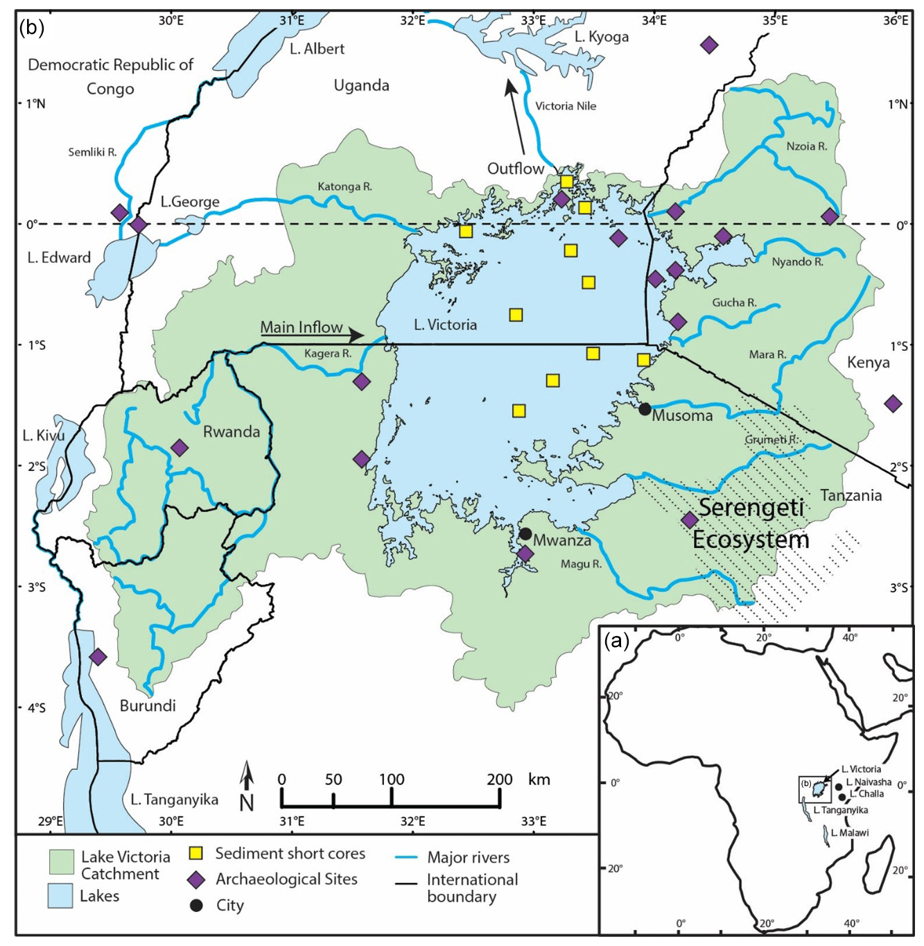
Figure 1Map of equatorial eastern Africa with the modern extent of Lake Victoria (modified after Beverly et al., 2020, and Tryon et al., 2015). Yellow squares denote previously collected short lake sediment core locations, and purple diamonds mark archaeological sites. See Tryon et al. (2015) for additional site details.
Initial conversations about integrating the rich lacustrine record within the lake with the geological, archaeological, paleontological, and paleoecological data from adjacent terrestrial deposits that formed under conditions substantially more arid than present began in 2015 at a meeting sponsored by Harvard University and organized by Christian Tryon. These initial conversations discussed the possibility of collecting new cores from Lake Victoria that spanned the entire sedimentary history of the lake to bridge the terrestrial and lacustrine records. The Lake Victoria Drilling Project (LVDP) began to take shape as discussions continued amongst the group and with project partner Tanzania Fisheries Research Institute (TAFIRI) and their Director General Ismael Kimirei. Prior to the LVDP workshop in 2022, meetings were also held with members of the LVDP team and faculty at the University of Dar es Salaam (UDSM), including Emmanual Kazimoto, Charles Kasanzu, and Fred Mkuyi, specifically to discuss potential areas of collaboration and needs of both the LVDP and UDSM.
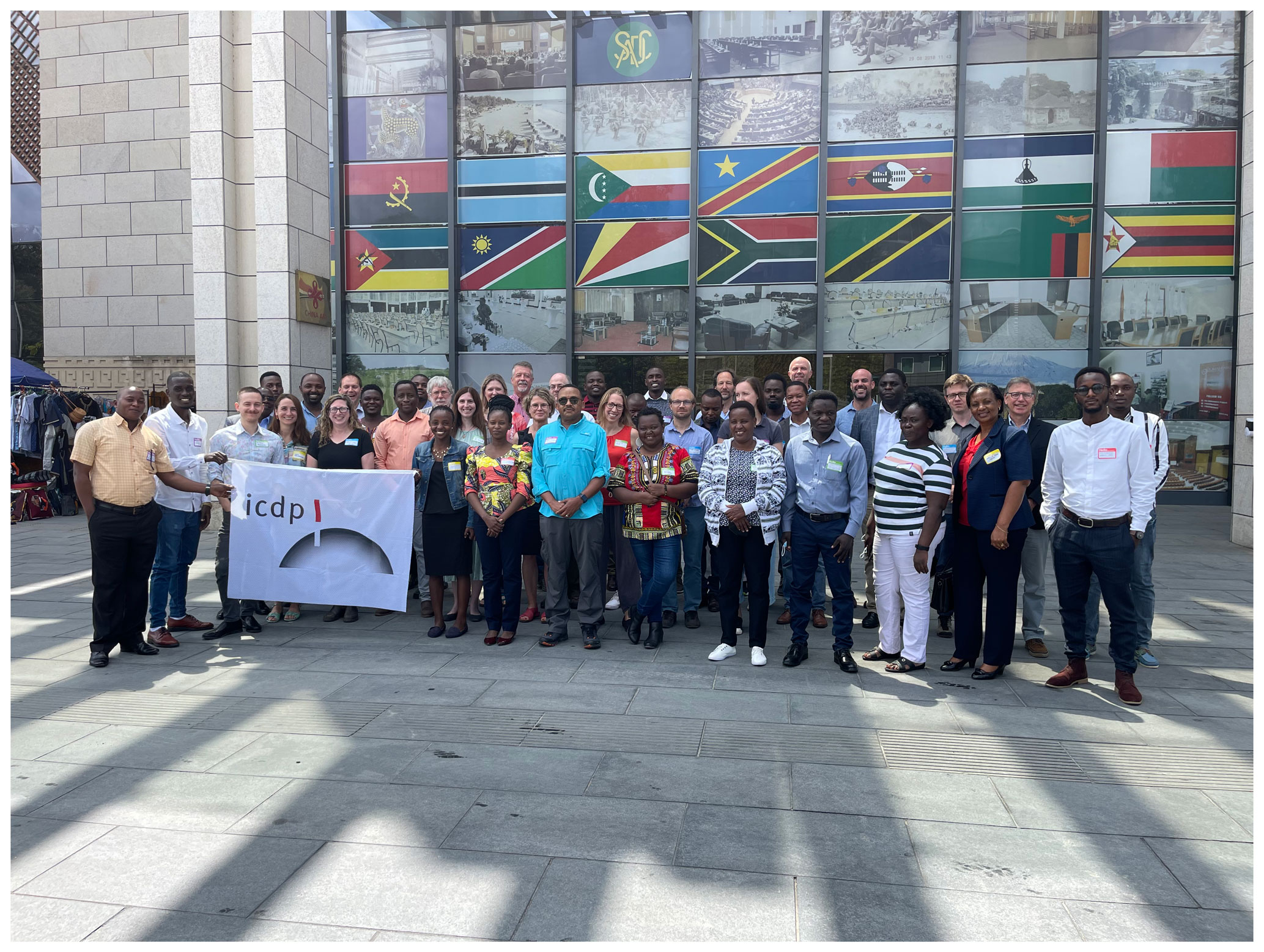
Figure 2Group photo of LVDP workshop participants at the Julius Nyerere International Convention Centre in Dar es Salaam, Tanzania.
These conversations, early small workshops, and conference presentations culminated in an integrated, multidisciplinary ICDP-supported LVDP workshop in Dar es Salaam, Tanzania, from 25–27 July 2022. The LVDP workshop was attended by ∼ 50 scientists from 10 countries (Fig. 2). African interest in the project was high, with ∼ 60 % of the attendance by African scientists and students from countries including Tanzania, Kenya, South Africa, and Burundi. The workshop focused on the current state of knowledge of the region and future opportunities that would be driven by deep scientific drilling. Workshop participants defined the key scientific questions to be answered by scientific drilling in Lake Victoria and outlined the necessary methodologies for success in those scientific goals; identified education, outreach, community engagement, and partnership-building goals for the project; and discussed logistical considerations, including site selection targets and permitting.
Lake Victoria straddles the Equator and occupies a broad topographic depression near the center of the eastern African plateau between the eastern and western branches of the East African Rift System (EARS) (Fig. 1). Most of the lake is surrounded by Archaean crust, except for the Winam Gulf in the northeastern corner where faulted Neogene and Quaternary alkali volcanic and sedimentary units dominate the terrain. During the Middle Pleistocene, continued uplift of the western branch of the EARS caused west-flowing regional drainage across the pre-rifted landscape to reverse, resulting in back-ponding and the formation of the precursor to Lake Victoria (Bishop and Trendall, 1966). Continued uplift of the western branch of the EARS has caused the center of the Lake Victoria basin to continually shift eastward since its formation. As a result of this uplift and tilting, the lake's early depositional history is exposed along its modern western margin. Lake Victoria has been interpreted to have formed ∼ 400 000 years ago. The current age estimates for the onset of Lake Victoria deposition are based on archaeological sites found within interstratified volcanic, fluvial, and lacustrine deposits in the Kagera River valley west of the lake (Bishop and Posnansky, 1960; Bishop, 1969; Temple and Doornkamp, 1970); Middle Pleistocene-aged lacustrine strata preserved above the eastern side of the modern lake near the Kavirondo Gulf (Kent, 1942); and extrapolations of sedimentation rates from the latest Pleistocene and Holocene portion of the lacustrine record to the entire lake sequence (Johnson et al., 1996).
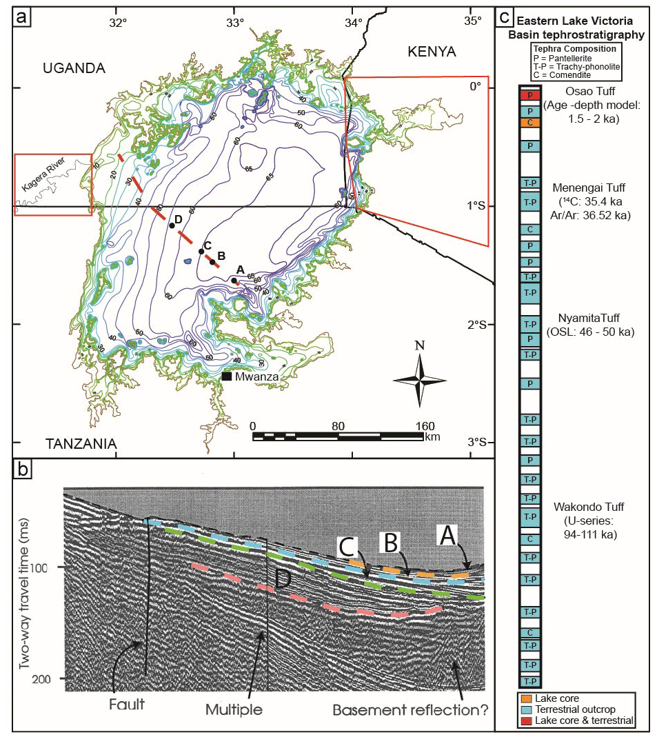
Figure 3(a) Bathymetric map of Lake Victoria with four lacustrine units, labeled A–D, that overlie the Miocene or older basement unit shown in panel (b). Red squares in Uganda and Kenya indicate location of prior terrestrial outcrop research. Dashed red line in the lake represents the seismic survey line shown in panel (b). Bathymetric lines indicate 10 m increments. (b) Seismic reflection profile from the 1995 IDEAL expedition of Lake Victoria (Johnson et al., 1996), with units described in panel (a). (c) Regional tephrostratigraphy generated from terrestrial outcrops and from IDEAL lake cores. Modified from Blegen et al. (2021).
Due to the nature of its formation and subsequent lake basin evolution, Lake Victoria is quite shallow, with a mean depth of ∼ 40 m and a maximum depth of ≤ 70 m (Johnson et al., 1996) (Fig. 3). The combination of an extremely large surface area relative to depth, and the connection between the lake, evaporation, and rainfall, makes the lake highly sensitive to hydroclimate variability. Today, rainfall in the Lake Victoria basin is distributed bimodally, with boreal spring “long rains” and boreal fall “short rains” (Herrmann and Mohr, 2011; Yang et al., 2015). Although the bimodal patterns of rainfall across eastern Africa are commonly linked to seasonal shifts of the Intertropical Convergence Zone (ITCZ), a recognizable ITCZ does not extend across eastern Africa (Nicholson, 2016; Vizy and Cook, 2020). Instead, precipitation in the Lake Victoria basin is created by complex interactions that include sea surface temperatures (SSTs), large-scale circulation, orographic effects, and regional-scale land–lake circulation (e.g., Ogallo and Janowiak, 1988; Mutai and Ward, 2000; Thiery et al., 2014). A significant portion of the water input into Lake Victoria (50 %–80 % of total input) comes from precipitation falling directly over the lake rather than from drainage running into the lake from the catchment area (Flohn and Burkhardt, 1985; Yin and Nicholson, 2002; Tate et al., 2004). Evaporation, while important for the lake's water balance, has low variability in modern Lake Victoria, and hence variations in lake levels are primarily controlled by changes in rainfall (Yin and Nicholson, 2002; Smith and Semazzi, 2014; Beverly et al., 2020).
However, in the past, changes in solar forcing and temperature in the Lake Victoria basin likely considerably effected evaporation, which could have caused changes in lake level (Beverly et al., 2020). Further, studies have linked climate conditions in the Lake Victoria region during parts of the Holocene and latest Pleistocene to teleconnections with the Pacific and Atlantic oceans (e.g., Atlantic Meridional Overturning Circulation (AMOC) and El Niño–Southern Oscillation (ENSO)) and high-latitude processes (e.g., Berke et al., 2012; Stager et al., 2011). The connection between regional climate and evaporation and rainfall on Lake Victoria makes the lake highly sensitive to climate forcing factors such as insolation, SSTs, and atmospheric greenhouse gas levels. This in turn means that intervals when the lake is significantly different in size have profound effects on regional climate, which causes major, nonlinear, and abrupt increases and reductions in lake size (e.g., Beverly et al., 2020). Further, in contrast to the long, narrow, and deep rift lakes with large border faults forming half-grabens (Malawi (750 m), Tanganyika (1500 m), and Turkana (110 m)), Lake Victoria's shallow depth (∼ 70 m) and large surface area likely result in very different catchment processes (e.g., Beverly et al., 2020) and responses to climate change than the large and deep rift lakes.
The long-core recovery proposed by the LVDP builds upon that of the International Decade of East African Lakes (IDEAL) that began in the 1990s (Johnson, 1991; Cohen et al., 2000). Several piston and gravity cores were recovered in 1995–1996 as part of the IDEAL program (Fig. 1). These cores penetrated 9 m of lacustrine sediment and were stopped by a paleosol dated at ∼ 15 ka (Johnson et al., 1996), due to limitations of the coring techniques at the time. Seismic reflection profiles obtained during the same expeditions revealed that the paleosol extends across the entire lake basin (Fig. 3b), indicating complete desiccation of the lake prior to 15 ka, perhaps during the Last Glacial Maximum (LGM) and extending through Heinrich event 1 (Johnson et al., 1996; Scholz et al., 1998; Talbot and Laerdal, 2000; Stager et al., 2002), when much of Africa experienced relatively cool, arid conditions (e.g., Otto-Bliesner et al., 2014). Existing seismic data reveal at least three more basin-wide paleosols (Fig. 3b). Although paleosols represent unconformities in the lacustrine deposits, which result in gaps in the lake record, they can be correlated and extended to terrestrial outcrops to provide a basin-wide reconstruction of past climates and environments during intervals when the lake was desiccated or considerably smaller than today and lacustrine sedimentation rates were low or erosion occurred (Fig. 3c). Unlike work conducted by the IDEAL project, drilling techniques that are now available to the LVDP are able to penetrate paleosol surfaces and thus not limited by the known lithology, which will help enable the recovery of Lake Victoria's entire sedimentary sequence. Utilizing the paleosols within the lacustrine sequence and correlating them to terrestrial deposits will make it possible to understand the powerful role of periodic desiccation and allow us to fully reconstruct the depositional and climate history of the lake and surrounding region and the impacts on faunal, including human, dispersal and evolution.
Application of drilling methods to recover sediments below the uppermost paleosol will provide the long-term record needed to uncover patterns key to understanding the timing, tempo, and causes of major fluctuations in Lake Victoria's extent throughout the Pleistocene; will clarify its relationship to the evolution of the region's flora and fauna; and will provide a key equatorial record of late Quaternary climate change. These data will in turn refine our ability to forecast future declines in lake level, which could be catastrophic to human populations in the region (e.g., Beverly et al., 2020; Olaka et al., 2019; Broecker et al., 1998; Milly, 1999). Past interglacials including MIS 5 (130 to 82 ka), MIS 9 (337 to 300 ka) and MIS 11 (424 to 374 ka) are of much scientific interest as they provide insights into the processes and mechanisms of climate change under conditions of elevated warmth. Drilling Lake Victoria will provide new high-resolution records that we hypothesize formed during interglacials from the continental tropics where few such records presently exist. These data will refine our ability to project future major shifts in lake level.
The LVDP workshop began with opening remarks and introductions, particularly focused on the history of the LVDP and the goal to recover the complete Lake Victoria sedimentary record (currently estimated to cover 400 ka–present, at ∼ 60 m length, based on modern sedimentation rates) and the work and operations of ICDP and the Continental Scientific Drilling (CSD) facilities at the University of Minnesota and project partners at the University of Dar es Salaam (UDSM) and TAFIRI. Following brief introductions from the other participants, the rest of the morning and early afternoon of the first workshop day was spent with brief presentations on the modern climatology of the region; a summary of past Victoria coring efforts and seismic surveys; the modern limnology; the hydrology and water balance; the perspective from current terrestrial fieldwork around the lake; chronology and volcanics; the paleoclimatology of the region; and likely synergies, such as with the National Museums of Kenya and the ongoing Olduvai Gorge Coring Project (OGCP).
We ended the first day of the workshop with small group discussions on the strengths of Lake Victoria as a site for future scientific deep drilling. Addressing what makes Lake Victoria a unique drill site, groups highlighted the following items in their presentations:
- i.
There is extensive, ongoing research on and understanding of paleosols and sediments present in outcrops around the lake. There is a unique opportunity at Lake Victoria for the integration of lacustrine and terrestrial records from the basin because these records can be directly linked by shared tephra deposits (Fig. 3).
- ii.
Well-studied terrestrial paleoanthropology/paleontology can be precisely tied to lake extent and environmental change. Lake level fluctuations also appear to be an important mechanism that drove the within-African dispersal of early populations of H. sapiens (Tryon et al., 2015). In this case, the paleosols developed on the lacustrine record are not viewed as “gaps” in more continuous data; instead they provide the means to quantify the climate of the region, including the degree of aridity that allowed them to form (e.g., Beverly et al., 2017), and provide a link between archaeological evidence for human behavior and sedimentary evidence for environmental change.
- iii.
Lake Victoria is an excellent location to understand floral and faunal evolution with respect to intervals of lake drying and expansion (including the endemic freshwater fish, cichlids). Particularly important to understand are the periods of lake desiccation and their impact on evolutionary history of the region's flora and fauna, including the central African rainforest and Serengeti ecosystems. Repeated intervals of lake desiccation and expansion likely played an important role in the speciation and adaptive radiation of endemic lake cichlids that dominate the aquatic food web in modern Lake Victoria and are central to debates on tempo and mode in evolution (e.g., Danley et al., 2012; Meier et al., 2017; Verheyen et al., 2003; Muschick et al., 2018).
- iv.
The broad, shallow nature of the lake and large surface area to catchment size compared to other African “Great Lakes” provide the potential to better understand the patterns and drivers of drying, critical for this water source and the millions of people that currently depend on it. Understanding the pattern and drivers of paleosol development is important not just for past responses but also for future projections and water scarcity risks (e.g., Beverly et al., 2020; Olaka et al., 2019). As the largest lake by surface area in Africa, millions of people are dependent on the lake water for life and livelihood.
- v.
Lake Victoria, as a large lake situated at the Equator, is an important place to study high- vs. low-latitude climate forcings. The unique location of Lake Victoria at the Equator, and relatively simple tectonic history that led to the formation of the lake compared to nearby rift lakes (e.g., Renaut and Owen, 2023), suggests that reconstruction of climate over glacial–interglacial cycles may be important to help us examine the relationship between orbital forcing, ice sheet extent, and more regional tropical patterns of climate variability (e.g., Stager et al., 2011). Additionally, how the changing spatial extent and inflows/outflows of Lake Victoria, the source of the White Nile, and the connection to the climate of the Mediterranean region have developed over these time intervals is unknown.
The second day of the workshop focused on breakout discussions by scientific working groups, beginning with a first set of sessions on key scientific questions that could be tackled with scientific drilling at Lake Victoria and a second session that focused on methods necessary to address key questions. These discussions included what additional science activities prior to drilling are needed to best position the LVDP team for success, what the requirements for on-site science activities and drill site locations are, and what other constraints on drilling operations are. Breakout groups consisted of (1) education/outreach/community engagement; (2) geochronology; (3) regional geology and geophysics; (4) paleoclimate/paleoenvironment/biogeochemistry; and (5) paleoecology to modern ecology/paleontology/evolutionary biology/paleoanthropology. Participants were encouraged to mix between groups based on their interests and expertise. Discussions culminated in presentations to all participants and aggregating themes across groups in order to shape our future drilling approach and make sure the widest set of scientific objectives could be met. The following is a summary of the key discussion points about LVDP opportunities from each breakout group.
4.1 Education, outreach, and community engagement
At some point during the workshop, all participants contributed to the education, outreach, and community engagement group, highlighting the central importance these connections and activities have to the entire LVDP. The group discussed what the LVDP could do to support local groups and stakeholders, the project's strengths, what the LVDP could bring to these partnerships, and how we would assess the success of these efforts. Leadership from TAFIRI and UDSM, as well as collaborators from Kenya Marine and Fisheries Research Institute (KMFRI), Tanzania Water Board, and other local agencies, provided critical insights into both the needs and interests of local groups and stakeholders, as well as how best to engage with these communities and assess the project's success in those endeavors. At the broadest scale, this would involve interaction with local stakeholders including managing agencies on the lake, universities, primary/secondary school children, and local communities before, during, and after drilling. Communication of the goals of the project to local communities would help with sustained community support and could involve climate change and longevity of water and fish resources. This is especially critical on Lake Victoria to prevent any loss of livelihood associated with fishing. Communication could be facilitated through fisheries agencies, such as with partners like TAFIRI, but the group discussed the possibility of primary and secondary school students as ambassadors to local community and families. Engagement with primary and secondary school students could come in the form of LVDP-sponsored activities, including citizen science activities that could include data collection following training, debates, or fun competitions (songs or other artistic endeavors). The group also discussed the forms that capacity building associated with the LVDP could take, including but not limited to on-the-ground training programs, visiting researcher and staff exchange, access to equipment to enhance scientific independence, and proposals with local universities to develop collaborative research around themes of joint interest.
4.2 Geochronology
The geochronology breakout group discussed the methodologies and necessary sampling considerations to provide the best possible framework for sediment recovered. A multi-technique approach to chronology for LVDP materials is best, likely occurring at multiple stages in the project. This is particularly important because the Lake Victoria record will sample both intervals of lacustrine sedimentation and paleosols, which likely represent depositional hiatuses in the lacustrine record. Ideally, chronological work begins with an overview of the recovered materials and working alongside sedimentologists to assess changes downcore. Redox changes are important to consider, as they may impact the utility of some proxies, such as 10Be. Additionally, some of the techniques require early core access, so that samples can be taken on relatively undisturbed materials (e.g., luminescence). Further, tephra techniques tie into advances in regional geology and the understanding of volcanic depositional history of the region and how those compositions evolved through time. Tephra techniques will also be a critical tool to link the lake record, and potentially the paleosols within the cores, to terrestrial deposits surrounding the lake. Primary techniques, considered so because of the age range and substrates, include luminescence dating, such as optically stimulated luminescence (OSL), quartz, < 100 ka) and post-infrared–infrared-stimulated luminescence (pIR-IRSL; feldspar, > 100 ka), 14C (< 50 ka), tephra, for correlation of outcrop to lake and dating via fingerprinting and 40Ar = 39Ar (if enough material is available, > 400 ka), and paleomagnetism (polarity stratigraphy and potentially paleomagnetic reversal, relative paleointensity, paleomagnetic secular variations). Secondary techniques, where suitable material may exist, could include 10Be decay, amino acid racemization on small samples, U-series dating on potential carbonates, and orbital tuning. Correlation between existing outcrop, piston core data (Fig. 3c), and newly generated LVDP geochronology may be possible, which would help strengthen the integration between the extensive past work in the region and new LVDP materials recovered.
4.3 Regional geology and geophysics
The regional geology and geophysics group focused on how the LVDP could help resolve long-standing questions about basin formation, sedimentation, tectonics, and volcanism in the region. From both the recovery of sediment cores, as well as interrogation of new and legacy geophysical data of the lake, the LVDP will address questions about how much sediment is present in the basin, the provenance of that sediment, and how this input has changed through time. The region is relatively tectonically quiescent compared to elsewhere in the rift system, and prior geophysical surveys found laterally continuous sediments (Fig. 3b) (Johnson et al., 1996; Scholz et al., 1998). The project could assess if recovered cores capture a record of seismicity and, with a better understanding of the tectono-sedimentary history of Lake Victoria, the possibility of rapidly shifting depocenters. The LVDP data would provide an opportunity to determine marginal uplift rates and the possibility to develop a detailed history of changing inflows and outflows to the lake and determine how those changes have impacted lake stratigraphy. Ultimately, we would incorporate the existing drainage networks with the history of rift shoulder uplift and seismic stratigraphic sequence and facies architecture to aid in our understanding of hydroclimate evolution of Lake Victoria. Results from the geophysical surveys and cores would be integrated with outcrop data from around the lake to better understand the regional geology and depositional history of the lake both when it was and was not present.
4.4 Paleoclimate, paleoenvironment, and biogeochemistry
This breakout group focused on how the LVDP would contribute to our understanding of paleoclimate and paleoenvironmental change in the region and associated biogeochemical changes within the lake that may be linked to terrestrial and atmospheric variability. Specifically, we would examine the drivers of climate change, looking at the role of high-latitude processes, such as ice sheet expansion or deglacial melting, in atmospheric circulation vs. low-latitude drivers, such as Indian or Atlantic Ocean changes in sea surface temperature. The lake is a sensitive recorder of desiccation and refilling, as interpreted from outcrop and existing geophysical survey data. Desiccation events are likely represented by paleosols within the lake record, which can potentially be correlated to terrestrial outcrops surrounding the modern lake. One of the major outstanding questions about the paleoclimate and paleoenvironmental history is as follows: what controlled these desiccation events? Whether each drying of the lake was due to the same driver or different regional and/or global climate drivers, the potential role that basinal tilting played, and whether desiccation and refilling events occur with some repeating cyclicity, will be investigated. Lake Victoria's connection to the Nile would allow us to compare a history of lake level changes with Nile runoff and, ultimately, changes around the Mediterranean Sea. Correlations between the lake cores and terrestrial deposits in the region would provide critical insights into the connection between lake level change and regional climate. Proxy reconstructions from a complete sedimentary record recovered from Lake Victoria would allow us to address questions of similarity to records elsewhere in Africa and provide an invaluable means of creating a high-resolution regional picture of climate and environmental change. This, in turn, would be used to better frame the extensive archaeological record around the region.
4.5 Paleoecology to modern ecology, paleontology, and evolutionary biology
The modern to paleoecological systems group focused on how to best integrate our understanding of modern Lake Victoria and surrounding basins with reconstructions of aquatic flora and fauna from various paleoproxies. Ideally, this would involve examining the connection between modern aquatic communities and ancient communities by trophic levels, evolutionary lineages, and understanding extinction of modern aquatic taxa. As part of the modern conditions informing the past, the group discussed how to leverage LVDP to advance existing and establish new regional modern observational studies and build partnerships with the agencies studying the lake and associated systems. The group discussed how the LVDP could examine questions of the evolution and rates (protracted vs. punctuated) of changes in fish populations (both native cichlids in the lake and introduced Nile perch, depending on core material recovered) and impacts of the changing environment and climate on these populations through time. Questions related to the causes and possible recurrence of shifting algae and other microbiota through time could be addressed, such as the shift in dominant phytoplankton and possible connection to changing fish populations. Understanding the hydrological connection to other lakes and rivers across the region, and how and when drainage changes may have occurred, will allow us to examine questions surrounding the impact of migration corridors for both aquatic and terrestrial fauna.
The final day of the workshop focused on discussions about logistics and site selection to meet the goal of recovering the complete sedimentary record of Lake Victoria), including recovering sediments and paleosols below those recovered in 1995 (> 15 ka, ∼ 6 m) (Johnson et al., 1996). Based on modern sedimentation rate estimates, the complete record is estimated to span ∼ 400 kyr and be ∼ 60 m in length. Existing seismic data, which are currently being reprocessed using modern techniques, and newly acquired high-resolution seismic data will need to be leveraged to determine the optimal drill sites. Based on existing data, the group determined that drilling in one geographic location would likely recover the lake's complete record. Further, the group advised that the site be chosen based on a combination of the longest possible sedimentary record and the least disturbed uppermost section (from sedimentary gas accumulation), while considering access to the site and onshore mobilization.
Site selection discussions at the time of the LVDP workshop were based on geophysical surveys from the 1980s and 1990s (Fig. 3b). The NSF-funded 1995 IDEAL expedition collected nearly 2000 km of seismic reflection profiles using a 16.4 cc (1 in.3) airgun (Scholz et al., 1998). Additionally, profiles were gathered from the 1985 Project PROBE survey, which collected multichannel seismic reflection data using a 2300 cc (140 in.3) seismic source (e.g., Rach and Rosendahl, 1989). However, coincident with the start of the LVDP workshop, a new, high-resolution geophysical survey of Lake Victoria was funded in 2022 by the National Science Foundation (NSF) and led by Christopher Scholz and in partnership with TAFIRI, in order to examine more of the lake's depositional history and optimize drilling locations. The survey, following meetings with TAFIRI scientists including Mary Kishe (Director of Research and Coordination) and Baraka Sekadende (Centre Director, Mwanza), was completed in Tanzanian waters (e.g., areas south of 1° S latitude) in January 2023 and used CHIRP (Compressed High Intensity Radiated Pulse) seismic reflection using an Edgetech 3200 XS profiler and SB-0512 towfish system. The modern CHIRP high-resolution profiles are coincident with the legacy 1995 and 1985 multichannel seismic data acquired using an airgun source. This reprocessed legacy multichannel data and new CHIRP data will be integrated to assess the fine-scale structural and stratigraphic framework across the basin and select the optimal site for drilling. Processing of data will continue through 2023, providing a better understanding of the sedimentary package and site selection by the end of the year. Additionally, an environmental impact assessment and sensitization campaigns around local communities, particularly with regards to any possible short-term fishery disruptions, need to occur early in project development.
Discussions by multidisciplinary scientists and regional stakeholders showed that broad interest and significance in the LVDP focused around (1) lacustrine basin formation and development, (2) tropical climate and environmental change over multiple glacial–interglacial cycles, (3) climate linkages to lake desiccation events, (4) diversification and evolution of aquatic fauna responding to lake dynamics and climate change, (5) climate and environmental pressures associated with lake extent driving dispersal of early human and animal populations, and (6) savanna ecosystem changes and their biogeographic implications. The LVDP offers this unique combination of research opportunities while also being highly complementary to lake drilling efforts elsewhere in eastern Africa. The LVDP team researchers (see below), made up of those attending the ICDP workshop July 2022, who have contributed to the LVDP since its earliest development, and those who have expressed an interest in the science and operations at Lake Victoria, will continue conversations and planning for the next steps of this project.
No data sets were used in this article.
Patrick Andrews (University of Texas, Austin, USA), Simon Armitage (Royal Holloway University of London, UK), Catherine Beck (Hamilton College, USA), Melissa A. Berke (University of Notre Dame, USA), Emily Beverly (University of Houston, USA), Cécile Blanchet (GFZ Potsdam, Germany), Simon Brassell (Indiana University Bloomington/Stone Age Institute, USA), Mariam Bundala (University of Dar es Salaam, Tanzania/University of Calgary, Canada), Kat Cantner (University of Minnesota/CSD Facility, USA), Isla Castañeda (University of Massachusetts Amherst, USA), Leon Clarke (Manchester Metropolitan University, UK), Kerry Cook (University of Texas, Austin, USA), Sara Emanuel (University of Dar es Salaam, Tanzania), John Tyler Faith (Natural History Museum of Utah/University of Utah, USA), Karen Fontijn (Université Libre de Bruxelles, Belgium), Martin Grosjean (University of Bern, Switzerland), Thomas Johnson (University of Massachusetts Amherst, USA), Claudia Johnson (Indiana University Bloomington, USA), Edmund Kajuni (Tanzania Fisheries Research Institute, Tanzania), Tumaini Kamulali (University of Arizona, USA/Tanzania Fisheries Research Institute, Tanzania), Charles Kasanzu (University of Dar es Salaam, Tanzania), Benedicto Kashindye (Tanzania Fisheries Research Institute, Tanzania), Emmanuel Kazimoto (University of Dar es Salaam, Tanzania), Jackson Kimambo (Wits University, South Africa), Ismael Kimirei (Tanzania Fisheries Research Institute, Tanzania), Rahab Kinyanjui (National Museums of Kenya, KE), Emmanuel Kisendi (Ministry of Water, Tanzania), Mary Kishe (Tanzania Fisheries Research Institute, Tanzania), Emily Kiswaka (University of Dar es Salaam, Tanzania), Sifan A. Koriche (Baylor University, USA), Christine Lane (University of Cambridge, UK), Muyo Machaule (University of Dar Es Salaam, Tanzania), Patrick Machumu (Tanzania Mining Commission, Tanzania), Stephen Peter Magohe (University of Dar es Salaam, Tanzania/University of Calgary, Canada), Marta Marchegiano (Vrije Universiteit Brussels, Belgium/University of Granada, ESP), Mbushi Charles Mbushi (University of Dodoma, Tanzania), Dhelda Mfanga (University of Dar es Salaam, Tanzania), Fred Mkuyi (University of Dar es Salaam, Tanzania), Elisante Mshiu (University of Dar es Salaam, Tanzania), Veronica Muiruri (National Museums of Kenya, KE), Moritz Muschick (University of Bern, Switzerland), Amy Myrbo (Amiable Consulting, USA), Hillary Mwongyera (University of Kansas, USA), Erick Ngaratoki (University of Dodoma, Tanzania), Elizabeth Niespolo (Princeton University, USA), Lambert Niyoyitungiye (University of Burundi, Burundi), Hope Yisi Mofor Njakoi (Tanzania Geological Society, Tanzania), Jackson Njau (Indiana University Bloomington/Stone Age Institute, USA), Anders Noren (University of Minnesota/CSD Facility, USA), Julian Ogondo (Maseno University, KE), Daniel Olago (University of Nairobi, KE), Lekeni Olle Moita (Syracuse University, USA), Collins Ongore (Kenya Marine and Fisheries Research Institute, KE/St Andrews University, UK), Daniel J. Peppe (Baylor University, USA), Simona Pierdominici (GFZ Potsdam, Germany), Nathan Rabideaux (Rutgers University Newark, USA), Violka Radmacher (Polish Academy of Sciences, Poland), Adam Renatus (Lake Victoria Basin Water Board, Tanzania), Mohamed Said (School of Mines and Geosciences, Tanzania), Salome Sharon (Tanzania Fisheries Research Institute, Tanzania), Kathy Schick (Indiana University Bloomington/Stone Age Institute, USA), Chris Scholz (Syracuse University, USA), Antje Schwalb (TU Braunschweig, Germany), Ole Seehausen (EAWAG, Switzerland), Baraka Sekadende (Tanzania Fisheries Research Institute, Tanzania), Mark Sier (CENIEH, Spain), Majura Sonogo (University of Dar es Salaam, Tanzania), Charlotte Spencer-Jones (Durham University, UK), Ian Stanistreet (University of Liverpool, UK/Stone Age Institute, USA), Harald Stollhofen (Friedrich-Alexander University Erlangen Nürnberg, Germany/Stone Age Institute, USA), Nicholas Toth (Indiana University Bloomington/Stone Age Institute, USA), Christian Tryon (University of Connecticut, USA), Edward Vizy (University of Texas, Austin, USA), Hendrik Vogel (University of Bern, Switzerland), Christian Zeeden (Leibniz Institute for Applied Geophysics, Germany), and Boyang Zhao (Brown University, USA).
MAB and DJP wrote the manuscript. All members of the LVDP team read the paper, provided feedback, and approved the final version.
The contact author has declared that none of the authors has any competing interests.
Publisher’s note: Copernicus Publications remains neutral with regard to jurisdictional claims made in the text, published maps, institutional affiliations, or any other geographical representation in this paper. While Copernicus Publications makes every effort to include appropriate place names, the final responsibility lies with the authors.
We would like to thank the Tanzania Fisheries Research Institute and the University of Dar es Salaam for logistical assistance in Tanzania; recommendations for the workshop location; and engaged participation and collaboration before, during, and after the workshop.
The workshop was supported by the International Continental Scientific Drilling Program.
This paper was edited by Tomoaki Morishita and reviewed by two anonymous referees.
Awange, J. L., Saleem, A., Sukhadiya, R. M., Ouma, Y. O., and Kexiang, H.: Physical dynamics of Lake Victoria over the past 34 years (1984–2018): Is the lake dying?, Sci. Total Environ., 658, 199–218, https://doi.org/10.1016/j.scitotenv.2018.12.051, 2019.
Berke, M. A., Johnson, T. C., Werne, J. P. Grice, K., Schouten, S., and Sinninghe Damsté, J. S.: Molecular records of climate variability and vegetation response since the Late Pleistocene in the Lake Victoria basin, East Africa, Quat. Sci. Rev., 55, 59–74, https://doi.org/10.1016/j.quascirev.2012.08.014, 2012.
Beverly, E. J., Peppe, D. J., Driese, S. G., Blegen, N., Faith, J. T., Tryon, C. A., and Stinchcomb, G. E.: Reconstruction of Late Pleistocene paleoenvironments using bulk geochemistry of paleosols from the Lake Victoria region, Front. Earth Sci., 5, https://doi.org/10.3389/feart.2017.00093, 2017.
Beverly, E. J., White, J. D., Peppe, D. J., Faith, J. T., Blegen, N., and Tryon, C. A.: Rapid Pleistocene desiccation and the future of Africa's Lake Victoria, Earth Planet. Sc. Lett., 530, 115883, https://doi.org/10.1016/j.epsl.2019.115883, 2020.
Bishop, W. W.: Pleistocene stratigraphy in Uganda, Geo. Survey of Uganda Mem. X, 1969.
Bishop, W. W. and Posnansky, M.: Pleistocene environments and early man in Uganda, Uganda J., 24, 44–61, 1960.
Bishop, W. W. and Trendall, A. F.: Erosion surfaces, tectonics, and volcanic activity in Uganda, Quart. J. Geo. Soc. Lon., 122, 385–420, 1966.
Blegen, N., Faith, J. T., and Peppe, D. J.: Tephrostratigraphy of the eastern Lake Victoria Basin including the Nyanza Rift, Kenya: building a stratigraphic and chronological framework for modern human evolution, Quaternary Sci. Rev., 256, 106823, https://doi.org/10.1016/j.quascirev.2021.106823, 2021.
Broecker, W. S., Peteet, D., Hajdas, I., Lin, J., and Clark, E.: Antiphasing between rainfall in Africa's Rift Valley and North America's Great Basin, Quaternary Res., 50, 12–20, https://doi.org/10.1006/qres.1998.1973, 1998.
Cohen, A. S., Scholz, C. A., and Johnson, T. C.: The International Decade of East African Lakes (IDEAL) drilling initiative for the African great lakes, J. Paleolim., 24, 231–235, https://doi.org/10.1023/A:1008158902422, 2000.
Danley, P. D., Husemann, M., Ding, B., Dipietro, L. M., Beverly, E. J., and Peppe, D. J.: The impact of the geologic history and paleoclimate on the diversification of East African cichlids, Int. J. Evo. Bio., 2012, 574851, https://doi.org/10.1155/2012/574851, 2012.
Faith, J. T., Tryon, C. A., Peppe, D. J., and Fox, D. L.: The fossil history of Grévy's zebra (Equus grevyi) in equatorial East Africa, J. Biog., 40, 359–369, https://doi.org/10.1111/j.1365-2699.2012.02796.x, 2013.
Faith, J. T., Tryon, C. A., Peppe, D. J., Beverly, E. J., and Blegen, N.: Biogeographic and Evolutionary Implications of an Extinct Late Pleistocene Impala from the Lake Victoria Basin, Kenya, J. Mamm. Evol., 21, 213–222, https://doi.org/10.1007/s10914-013-9238-1, 2014.
Faith, J. T., Tryon, C. A., and Peppe, D. J.: Environmental change, ungulate biogeography, and their implications for early human dispersals in equatorial East Africa, in: Africa from MIS 6-2: Population Dynamics and Paleoenvironments, edited by: Jones, S. C. and Stewart, B. A., Springer, Dordrecht, 233–245, https://doi.org/10.1007/978-94-017-7520-5_13, 2016.
Flohn, H. and Burkhardt, T.: Nile runoff at Aswan and Lake Victoria: a case of a discontinuous climate time series, Zeits. Gletsch. Glaz., 21, 125–130, 1985.
Herrmann, S. M. and Mohr, K. I.: A continental-scale classification of rainfall seasonality regimes in Africa based on gridded precipitation and land surface temperature products, J. Appl. Meteorol. Clim., 50, 2504–2513, https://doi.org/10.1175/JAMC-D-11-024.1, 2011.
Johnson, T. C.: International Decade of East African Lakes, Eos T. Am. Geophys. Un., 72, 258–259, https://doi.org/10.1029/90EO00198, 1991.
Johnson, T. C., Scholz, C. A., Talbot, M. R., Kelts, K., Ricketts, R. D., Ngobi, G., Beuning, K., Ssemmanda, I., and McGill, J. W.: Late Pleistocene desiccation of Lake Victoria and rapid evolution of cichlid fishes, Science, 273, 1091–1093, https://doi.org/10.1126/science.273.5278.1091, 1996.
Kent, P. E.: The country round the Kavirondo Gulf of Victoria Nyanza, Geog. J., 100, 22–31, https://doi.org/10.2307/1789231, 1942.
Kingdon, J., Happold, D., Butynski, T., Hoffman, M., and Kalina, J.: Mammals of Africa (Vol. I–VI), Bloomsbury Publishing, London, ISBN 9781408189962, 2013.
Meier, J. I., Marques, D. A., Mwaiko, S., Wagner, C. E., Excoffier, L., and Seehausen, O.: Ancient hybridization fuels rapid cichlid fish adaptive radiations, Nat. Commun., 8, 14363, https://doi.org/10.1038/ncomms14363, 2017.
Milly, P. C. D.: Comment on “Antiphasing between Rainfall in Africa's Rift Valley and North America's Great Basin”, Quaternay Res., 51, 104–107, https://doi.org/10.1006/qres.1998.2011, 1999.
Muschick, M., Russell, J. M., Jemmi, E., Walker, J., Stewart, K. M., Murray, A. M., Dubois, N., Stager, J. C., Johnson, T. C., and Seehausen, O.: Arrival order and release from competition does not explain why haplochromine cichlids radiated in Lake Victoria, Philos. T. Roy. Soc. B., 285, ISSN 1471-2954, https://doi.org/10.1098/rspb.2018.0462, 2018.
Mutai, C. C. and Ward, M. N.: East African rainfall and the tropical circulation/convection on intraseasonal to interannual timescales, J. Climate, 13, 3915–3939, https://doi.org/10.1175/1520-0442(2000)013<3915:EARATT>2.0.CO;2, 2000.
Nicholson, S. E.: The Turkana low-level jet: mean climatology and association with regional aridity, Int. J. Climatol., 36, 2598–2614, https://doi.org/10.1002/joc.4515, 2016.
Ogallo, L. J. and Janowiak, J. E.: Teleconnection between seasonal rainfall over East Africa and global sea surface temperature anomalies, J. Meteorol. Soc. Jpn. Ser. II, 66, 807–822, https://doi.org/10.2151/jmsj1965.66.6_807, 1988.
Ogondo, J., Oindo, B., Olago, D. O., and Woodborne, S.: Bulk sediment geochemistry, a proxy palaeowater quality indicator of the Mid-Late Pleistocene beaches of Rusinga-Mfangano Islands, Lake Victoria, Kenya, Maseno Uni. Jour., 1, 65–81, https://www.maseno.ac.ke/sites/default/files/2022-05/MASENO UNIVERSITY JOURNAL Volume 1-2022-18-Apr-2022-Collins-Final.pdf (last access: August 2023), 2022.
Olaka, L. A., Ogutu, J. O., Said, M. Y., and Oludhe, C.: Projected Climatic and Hydrologic Changes to Lake Victoria Basin Rivers under Three RCP Emission Scenarios for 2015–2100 and Impacts on the Water Sector, Water, 11, 1449, https://doi.org/10.3390/w11071449, 2019.
Otto-Bliesner, B. L., Russell, J. M., Clark, P. U., Liu, Z., Overpeck, J. T., Konecky, B., deMenocal, P., Nicholson, S. E., He, F., and Lu, Z.: Coherent changes of southeastern equatorial and northern African rainfall during the last deglaciation, Science 346, 1223-1227, https://doi.org/10.1126/science.1259531, 2014.
Rach, N. M. and Rosendahl, B. R.: Tectonic controls on the Speke Gulf, J. Afr. Ear. Sci. (and the Middle East), 8, 471–488, https://doi.org/10.1016/S0899-5362(89)80040-5, 1989.
Renaut, R. W. and Owen, R. B.: Lake Victoria Basin, in: The Kenya Rift Lakes: Modern and Ancient: Limnology and Limnogeology of Tropical Lakes in a Continental Rift, Springer Berlin Heidelberg, Berlin, Heidelberg, 883–905, ISBN 3-642-25054-8, 2023.
Scholz, C. A., Johnson, T. C., Cattaneo, P., Malinga, H., and Shana, S.: Environmental Change and Response in East African Lakes, edited by: Lehman, J. T., Springer, 47–58, https://doi.org/10.1007/978-94-017-1437-2, 1998.
Seehausen, O.: Lake Victoria Rock Cichlids: taxonomy, ecology, and distribution, Verduijn Cichlids, Zevenhuizen, the Netherlands, ISBN 9789080018167, 1996.
Smith, K. A. and Semazzi, F. H. M.: The role of dominant modes of precipitation variability over Eastern Africa in modulating the hydrology of Lake Victoria, Adv. Meteorol., 2014, 516762, https://doi.org/10.1155/2014/516762, 2014.
Stager, J. C., Mayewski, P. A., and Meeker, L. D.: Cooling cycles, Heinrich event 1, and the desiccation of Lake Victoria, Palaeogeogr. Palaeocl., 183, 169–178, https://doi.org/10.1016/S0031-0182(01)00468-0, 2002.
Stager, J. C., Ryves, D. B., Chase, B. M., and Pausata, F. S. R.: Catastrophic Drought in the Afro-Asian Monsoon Region During Heinrich Event 1, Science, 331, 1299–1302, https://doi.org/10.1126/science.1198322, 2011.
Talbot, M. R. and Laerdal, T.: The Late Pleistocene-Holocene paleolimnology of Lake Victoria, East Africa, based upon elemental and isotopic analyses of sedimentary organic matter, J. Paleolimnol., 23, 141–164, https://doi.org/10.1023/A:1008029400463, 2000.
Tate, E., Sutcliffe, J., Conway, D., and Farquharson, F.: Water balance of Lake Victoria: Update to 2000 and climate change modeling to 2100, Hydrolog. Sci. J., 49, 563–574, https://doi.org/10.1623/hysj.49.4.563.54422, 2004.
Temple, P. H. and Doornkamp, J. C.: Influences controlling lacustrine overlap along the north-western margins of Lake Victoria, Z. Geomorphol., 14, 301–317, 1970.
Thiery, W., Martynov, A., Darchambeau, F., Descy, J.-P., Plisnier, P.-D., Sushama, L., and van Lipzig, N. P. M.: Understanding the performance of the FLake model over two African Great Lakes, Geosci. Model Dev., 7, 317–337, https://doi.org/10.5194/gmd-7-317-2014, 2014.
Tryon, C. A. and Faith, J. T.: Variability in the Middle Stone Age of Eastern Africa, Curr. Anthropol., 54, S234–S254, https://doi.org/10.1086/673752, 2013.
Tryon, C. A., Faith, J. T., Peppe, D. J., Beverly, E. J., Blegen, N., Blumenthal, S. A., Chritz, K. L., Driese, S. G., Patterson, D., and Sharp, W. D.: The Pleistocene prehistory of the Lake Victoria basin, Quatern. Int., 404, 100–114, https://doi.org/10.1016/j.quaint.2015.11.073, 2015.
Vanderkelen, I., van Lipzig, N. P. M., and Thiery, W.: Modelling the water balance of Lake Victoria (East Africa) – Part 2: Future projections, Hydrol. Earth Syst. Sci., 22, 5527–5549, https://doi.org/10.5194/hess-22-5527-2018, 2018.
Verheyen, E., Salzburger, W., Snoeks, J., and Meyer, A.: Origin of the Superflock of Cichlid Fishes from Lake Victoria, East Africa, Science, 300, 325–329, https://doi.org/10.1126/science.1080699, 2003.
Vizy, E. K. and Cook, K. H.: Interannual variability of East African rainfall: Role of seasonal transitions of the low-level cross-equatorial flow, Clim. Dynam., 54, 4563–4587, https://doi.org/10.1007/s00382-020-05244-z, 2020.
Yang, W., Seager, R., Cane, M. A., and Lyon, B.: The annual cycle of East African precipitation, J. Climate, 28, 2385–2404, https://doi.org/10.1175/JCLI-D-14-00484.1, 2015.
Yin, X. and Nicholson, S. E.: Interpreting annual rainfall from the levels of Lake Victoria, J. Hydrometeorol., 3, 406–416, https://doi.org/10.1175/1525-7541(2002)003<0406:IARFTL>2.0.CO;2, 2002.
- Abstract
- Introduction
- Current knowledge and drilling rationale
- Workshop structure and discussions
- LVDP workshop breakout groups
- Logistics
- Workshop conclusions and next steps
- Data availability
- Team list
- Author contributions
- Competing interests
- Disclaimer
- Acknowledgements
- Financial support
- Review statement
- References