the Creative Commons Attribution 4.0 License.
the Creative Commons Attribution 4.0 License.
 | 17 Jun 2024
ICDP workshop on the Deep Drilling in the Turkana Basin project: exploring the link between environmental factors and hominin evolution over the past 4 Myr
Melissa Berke
Craig S. Feibel
Verena Foerster
Lydia Olaka
Helen M. Roberts
Christopher A. Scholz
Kat Cantner
Anders Noren
Geoffery Mibei Kiptoo
James Muirhead
Scientific drill cores provide unique windows into the processes of the past and present. In the dynamic tectonic, environmental, climatic, and ecological setting that is eastern Africa, records recovered through scientific drilling enable us to look at change through time in unprecedented ways. Cores from the East African Rift System can provide valuable information about the context in which hominins have evolved in one of the key regions of hominin evolution over the past 4 Myr. The Deep Drilling in the Turkana Basin (DDTB) project seeks to explore the impact of several types of evolution (tectonic, climatic, biological) on ecosystems and environments. This includes addressing questions regarding the region's complex and interrelated rifting and magmatic history, as well as understanding processes of sedimentation and associated hydrothermal systems within the East African Rift System. We seek to determine the relative impacts of tectonic and climatic evolution on eastern African ecosystems. We ask the follow questions: what role (if any) did climate change play in the evolution of hominins? How can our understanding of past environmental change guide our planning for a future shaped by anthropogenic climate change?
To organize the scientific community's goals for deep coring in the Turkana Basin, we hosted a 4 d ICDP supported workshop in Nairobi, Kenya, in July 2022. The team focused on how a 4 Myr sedimentary core from the Turkana Basin will uniquely address key scientific research objectives related to basin evolution, paleoclimate, paleoenvironment, and modern resources. Participants also discussed how DDTB could collaborate with community partners in the Turkana Basin, particularly around the themes of access to water and education. The team concluded that collecting the proposed Pliocene to modern record is best accomplished through a two-phase drilling project with a land-based transect of four cores spanning the interval from 4 Ma to the Middle–Late Pleistocene (< 0.7 Ma) and a lake-based core targeting the interval from ∼ 1 Ma to present. The second phase, while logistically more challenging due to the lack of drilling infrastructure currently on Lake Turkana, would revolutionize our understanding of a significant interval in the evolution and migration of Homo sapiens for a time period not currently accessible from the Kenyan part of the Turkana Basin. Collectively, the DDTB project will provide exceptional tectonic and climatic data directly associated with one of the world's richest hominin fossil localities.
- Article
(5068 KB) - Full-text XML
- BibTeX
- EndNote


Questions of who we are, where we came from, and why we are the way we are as a species are among the most fundamental of scientific enquiries. Eastern Africa is crucial for understanding the story of hominin evolution and dispersal due to the richness and extent of the archaeological and fossil records. The Turkana Basin, located in the East African Rift System (EARS) (Fig. 1), is of particular significance with more than 500 hominin fossil discoveries from the region (Wood and Leakey, 2011). Hominin evolution and dispersal has taken place against a backdrop of dramatic changes in the Earth's climate (e.g., Bergström et al., 2021; Mounier and Mirazón Lahr, 2019), resulting in major changes to the environment in which our human ancestors were living. Links between environmental change and human evolution have long been hypothesized (e.g., Vrba et al., 1989), including specific climatic shifts and key events in human evolution, such as early human speciation patterns, brain expansion, and species dispersal (e.g., Shultz and Maslin, 2013), and major revolutions in tool making technology (e.g., deMenocal, 2011; Potts et al., 2020). However the relationship between paleoclimate, paleoenvironment, and hominin evolution and dispersal remains unclear and is a matter of ongoing debate (e.g., Faith et al., 2021). Furthermore, in settings such as the EARS, tectonic influences exert a confounding influence on the record of environmental change. The major factor impeding the exploration of links between the changing environment due to climate and tectonic influences and the existing record of hominin evolution and dispersal is the lack of continuous, high-resolution sedimentary records documenting the changing environment over long timescales, commensurate with those relevant to hominin evolution (Cohen et al., 2022; Russell et al., 2012). Through the proposed Deep Drilling in the Turkana Basin (DDTB) project, we seek to build upon the promising advances made in the past decade by other eastern African continental deep drilling projects with the ambitious goal of recovering a composite core record from 4 Ma to present for the Turkana Basin without temporal gaps. The proposed core record would address major research questions including how tectonic extension in the East African Rift System has shaped the environment and climate of the region through time, the effects of cyclical climatic changes on the environment, and how the evolution of hominins and the ecosystems surrounding them has been shaped by climatic and tectonic drivers.
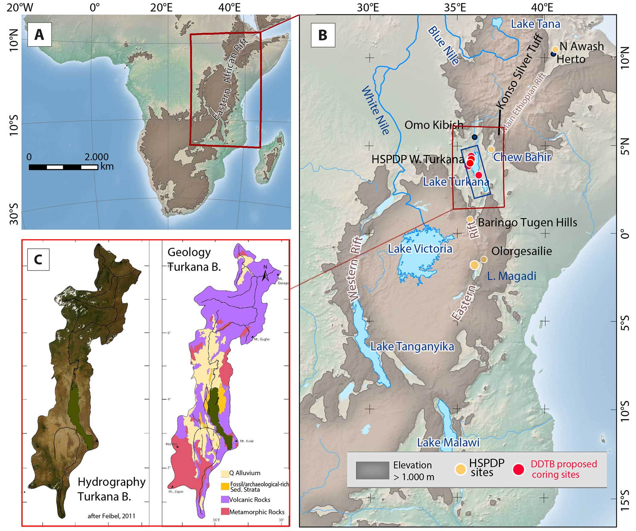
Figure 1Map of the Turkana Basin (TB) and its location. (a) Rift systems and highland areas in excess of 1000 m elevation. (b) East African Rift System with major lakes, key archaeological sites, and former HSPDP coring sites discussed in the text. The proposed DDTB drilling sites are marked with red circles. The blue box marks the Turkana region for which seismic reflection profile tracklines are available (Fig. 3). (c) The modern Lake Turkana catchment with hydrography and simplified geology (modified after Feibel, 2011).
The primary research goals of the project are as follows:
-
To establish a continuous high-resolution record of climate and environmental variability for the past 4 Myr in the Turkana Basin. This will allow direct comparison with trends and events recorded in the rich paleontological and archaeological record recovered from the basin.
-
To investigate linkages between tectonic evolution and magmatic development in the basin. A better understanding of the tectono-magmatic evolution in Turkana will have broad implications for our understanding of this continental rift setting.
-
To chronicle long-term evolution of the Turkana hydrographic system. This has critical implications for water development issues in the present and for the development of the Turkana hydrologic network in the past.
-
To expand our understanding of geothermal systems within the basin. This is a key area for potential development in the basin and is of significance to understanding thermal signatures in the rock and fossil record.
-
To track the dynamics of ecological systems within both lacustrine and terrestrial communities in Turkana. This will help better understand current responses to environmental change, human resource demands, and the broader pattern of long-term response to environmental drivers.
1.1 Tectonic evolution
Extensional tectonic processes in the Turkana Basin play a key role in driving the local topographic variations that affect the distribution of the surface and subsurface hydrology and associated ecosystems in the region. In addition to addressing questions of our own origins in the context of a changing climate, a long core retrieved from the Turkana Basin would give unique insight into the complex tectonic development, fault geometries, and hydrothermal systems within the EARS. Extension in the Turkana Basin is linked to NW–SE-trending Mesozoic–Paleogene rifts overprinted by the younger Oligocene–Miocene to Recent N–S-trending EARS (Boone et al., 2018a). Thermochronology studies in the region provide evidence for tectonic activity in the Turkana Basin that predates all other sectors of the EARS (Reeves et al., 1987; Foster and Gleadow, 1996; Torres Acosta et al., 2015; Boone et al., 2018a, b), with early volcanism dated at 39.2 Ma prior to the ∼ 31 Ma Ethiopia flood basalt eruptions (Rooney, 2017). Today the Turkana Basin continues to experience rifting (Knappe et al., 2020) and is a classic example of extension in a magma-rich setting, where magmatic activity has been essential in promoting and modulating continental extension and crustal thinning (Muirhead et al., 2022; Rooney et al., 2022). Border faults segment the rift into a series of linked half-graben basins, each ∼ 30–50 km long (Dunkelman et al., 1989). Deep sedimentary sections observed in multichannel seismic (MCS) reflection data thicken towards the border faults, and shallow Late Quaternary sediments thicken towards recently developed axial magmatic segments in the center of rift (Muirhead et al., 2022), indicating ongoing syn-rift sedimentation (Fig. 1).
The Turkana region is a tectonic anomaly within the EARS overall, in that it is a broadly rifted zone that has experienced complex episodes of rifting and magmatism spanning more than 30 Myr (Baker and Wohlenberg, 1971; Cerling and Powers, 1977; Morley et al., 1992, 1999; Haileab et al., 2004; Furman et al., 2004, 2006; Rooney, 2017). Unlike most sectors of the EARS, it is underlain by thin crust and shallow Moho and presumably high heat flow (Wheidon et al., 1994), which makes it an active target for geothermal exploration (Dunkley et al., 1993). Whereas faults elsewhere in the EARS are generally steep and planar, older basins in Turkana (e.g., the Lokichar Basin) display evidence of listric and potentially detachment faulting in places (Morley et al., 1999). The length scales of proposed rift segments are also generally shorter than other areas in the EARS (Ebinger et al., 1999), possibly reflecting the comparatively thinner, warmer crust in the region (Rosendahl et al., 1992). Finally, models for mature continental rifts in the eastern branch (e.g., Ethiopia) suggest that rifting initiates on border faults, but later migrates to intra-rift structures with time (Corti, 2009; Ebinger and Casey, 2001; Keranen et al., 2004; Nutz et al., 2020). This standard model of rift evolution, however, does not apparently apply to older (> 10 Ma) rift segments in Turkana, which also lack evidence for persistent axial magmatism (e.g., Lokichar and Kerio basin segments; Morley, 2020).
However, recent investigations into fault behavior in the South Turkana Basin reveal evidence for strain focusing into intra-rift fault populations in association with developing axial magmatism beginning in the Middle to Late Pleistocene, consistent with volcano–tectonic patterns observed across the eastern branch generally (Muirhead et al., 2016; Rooney, 2020; Muirhead et al., 2022; Rooney et al., 2022). Although these observations suggest that magmatism has played a critical role in driving the distribution of faulting and development of rift topography in the Turkana Basin in the Late Quaternary, the majority of earlier tectonic activity recorded in Lake Turkana (i.e., prior to 20 ka) is poorly resolved (Morrissey and Scholz, 2014; Muirhead et al., 2022), due in part to the absence of samples of the deep sedimentary section below the lake. Though reflection seismic data reveal that the history and tectonic evolution of continental rifting is likely contained within the stratigraphic sequences of the Turkana Basin (e.g., Dunkelman et al., 1989; Morley et al., 1999; Muirhead et al., 2022), analysis of drill cores, in conjunction with seismic stratigraphic analyses, will enhance and refine our understanding of the tectonic history of this rift system over the last ∼ 4 Myr.
1.2 Water and ecological resources
The story of water as a resource in the past and present is at the heart of the Turkana Basin record. The lake has varied in size throughout its existence, regulated by tectonics, volcanism, and climate change, which in turn combine to shape the hydrology and ecosystem functions through time. Modern Lake Turkana is the world's largest desert lake (Ojwang et al., 2016). While the water is not potable for humans (Avery and Eng, 2012; Ojwang et al., 2016) due to a high pH (8.6–9.5) and salinity (ca. 3500 µS cm−1), the health of this water body is essential to the ecosystems services that sustain humans today in the region. In particular, the fisheries industry has become a significant source of food and revenue for the region (Gownaris et al., 2015, and references therein). While traditionally the indigenous people have been pastoralists (Leslie and Fry, 1989), beginning in 1961 and continuing today, Lake Turkana supports a large fishing industry born out of a need to diversify the local economy (Avery, 2010; Bayley, 1982). Overfishing and fishing of juveniles have already stressed key fish species, reducing their resiliency and making populations more vulnerable to the impacts of climate change and human disturbance, particularly in crucial breeding grounds such as Ferguson's Gulf (Hopson, 1982; Avery, 2010; Gownaris et al., 2015). Data on the fish stocks in Lake Turkana are sparse, given the size of the lake and the scant resources available for monitoring efforts (Obiero et al., 2022). Coupling decreasing lake levels with already stressed ecosystems could decimate the fish populations many of the local communities have come to rely upon for food and income (Velpuri et al., 2012; Beck et al., 2021).
A better baseline assessment of how ecosystems have responded to changes in water and sediment input through time is necessary to assess and predict how Lake Turkana will respond to future changes in fluvial input and climate shifts. This information would help inform policy makers and draw attention to the serious issues facing the lake system today. By comparing proxy records of lake conditions, particularly ostracod assemblages, from pre- and post-onset of industrial-scale fishing in 1961 and the Gibe Dam Project construction in 1998, it is possible to evaluate the lake's response to both natural and anthropogenic changes (Beck et al., 2021). Our paleo-baseline from the proposed coring activity would help quantify the hydrological budget to better constrain the role of climate change vulnerability and dry–wet oscillations on human-scale ecosystems through time. Sub-Saharan Africa is one of the most vulnerable regions to future climate change, with widespread and until now uncertain impacts on African environments and society, as predicted by the IPCC reports (IPCC, 2014). The “deep time” perspective allows significant opportunities to test the sensitivity of systems to lake level variability.
Groundwater resources are important in this arid to semi-arid landscape. Groundwater in some regions of the Turkana Basin has been mapped through subsurface geophysics (Gramling, 2013; Nyaberi et al., 2019) but has not yet yielded the much anticipated fresh water resources as the quality does not meet the health guidelines (Rusiniak et al., 2021; Mbugua et al., 2022). In addition, the quality of shallow groundwater in areas of settlement is impacted by anthropogenic contamination (Tanui et al., 2020). Understanding of the groundwater system in the Turkana Basin is complicated by the fact that the tectonic, environmental, and volcanic processes have created discontinuous and heterogeneous aquifers (Olaka et al., 2022). This necessitates using multiple techniques (geophysical, geochemical, and geological) to determine the factors that control groundwater quality, quantity and dynamics. Our project has the potential to contribute to a comprehensive analytical approach which will not only ensure location and sustainable management of groundwater resources for the different needs (domestic, agriculture, industrial) but also help inform the hydrogeological recharge models related to hydrothermal systems, thereby supporting the exploration of geothermal resources.
Deep drilling in the Turkana Basin will provide the archives essential for constraining regional climate controls and hydrological responses, linking the dynamics of faunal/floral communities and cultural development with environmental parameters and spanning the entire range of hominin evolution from ∼ 4 Ma to present, covering the full diversity of hominin/human technological (i.e., stone tool) development. A Turkana record of the past also could help the regional and global communities prepare for the challenges that lie ahead in a future dramatically shaped by unprecedented climate change.
1.3 Geothermal resources
The intricate interplay of volcanism and tectonism in the EARS provides a suitable environment for high heat flow and fault-controlled deep fluid circulation. This is the main reason that the EARS is associated with abundant geothermal resources. Because of the early (39.2 Ma; Rooney, 2017) volcanism and the rifting that followed, the Turkana Basin is a key geothermal resource area of interest in Kenya. Five Quaternary volcanic centers occur in Turkana, including the Korath range; the North Island, Central Island, and South Islands; and the Barrier complex (Bloomer et al., 1989). The Barrier volcanic center is of particular interest to geothermal exploration due to its location and numerous geothermal manifestations including altered ground, fumaroles, caldera structures, and recent volcanic eruptions (Njau et al., 2020).
Exploration of geothermal potential is actively ongoing in the Turkana Basin as Olsuswa Energy owns the geothermal exploration license in the Barrier and has begun surface exploration in the area. The present scientific deep drilling project would be of immense importance to geothermal exploration in the area in several ways. The drill cores obtained will provide high-resolution stratigraphic information of the Turkana Basin, including micro- and macro-subsurface structures. This will guide the development of a quality geothermal drilling prognosis and a better understanding of subsurface permeability through structural analysis from direct core information. The resulting boreholes could also provide important information for calculation of geothermal gradient building on the earlier regional data by Wheildon et al. (1994). In addition, water samples from the drill wells would be key in fluid chemical characterization, geothermometry, and possibly age information, further assisting in understanding the geothermal reservoirs and the areas geothermal conceptual models and hence facilitating geothermal exploration programs. Furthermore, understanding the regional structural and volcanic history is significant as the Turkana Basin is potentially the only region within the Kenya Rift where extensive basalt flows occur, and thus it could provide opportunities in other energy and environmental projects like carbon storage research. As a result, there is a natural linkage between potential scientific drilling and geothermal resource development in the Turkana Basin.
The goal of obtaining a long core record linked closely to human origins in Turkana has deep roots, beginning with a US National Science Foundation (NSF) workshop in 1978 (Lewin, 1981). More recently, a continental drilling workshop held in 2011 prioritized drilling of Lake Turkana as one of the most important future targets for addressing outstanding scientific questions in eastern Africa (Russell et al., 2012). The report from this 2011 workshop concluded that future deep drilling of Turkana would integrate well with the then-planned (now successfully executed) Hominin Sites and Paleolake Drilling Project (HSPDP), which cored a short window of the Early Pleistocene lacustrine-dominated sequence in West Turkana (WTK13) (Fig. 1). In April 2018 a workshop supported by the NSF-funded Research Coordination Network (RCN) EarthRates outlined objectives for the next phase of scientific drilling and coring in the Turkana Basin. The goal of the 2018 workshop was to define potential coring targets in the Turkana Basin of interest to the broader scientific community that could contribute to the next decade of scientific discovery about the paleoclimatic and paleoenvironmental context in which our ancestors evolved. The workshop attendees consisted of 12 scientists from the USA (9 participants) and Kenya (3 participants), and an additional 13 participants joined the live stream of the workshop over the 2 workshop days. The group quickly coalesced around the idea of prioritizing recovery of the entire Plio-Pleistocene record in the Turkana Basin. The rationale for this is that the richness of the Turkana Basin fossil record provides the unique opportunity to study the paleoclimatic and paleoenvironmental context surrounding continuous occupation by hominin groups. This has implications for both physical and cultural evolution. Whilst outcrops expose short windows into the archives of the past, they are complicated by their limited temporal range for any given location and obscured through modern soil processes. Only deep drilling can capture the entire, and minimally altered, sedimentary sequence describing the climate and environmental conditions throughout the last 4 Myr of hominin evolution, migration and dispersal.
Data from existing Turkana Basin sediment cores are narrowly focused in terms of temporal scope, coming from three sources (Fig. 2):
-
The Hominin Sites and Paleolakes Drilling Project (HSPDP) drilled a 216 m record from West Turkana (WTK13), recovering an interval from 1.9–1.4 Ma (Cohen et al., 2016; Sier et al., 2017; Lupien et al., 2018, 2020). The cores showed a progression from a deep basin to a lake margin to a delta plain (Beck, 2015). The WTK core provided an unparalleled view of deposition on a dynamic lake margin, enhancing the community's understanding of the scale of hydrologic variability (Beck et al., 2017; Feibel et al., 2017), its impact on hominin evolution (Campisano et al., 2017), and the implications of climate versus tectonic evolution for rift basins (Lupien et al., 2018). There is also thought to be a connection of lake level and enhanced/weakened Indian Ocean monsoon variability. Lupien et al. (2018) found fairly stable hydroclimate conditions responding to changes in insolation using leaf wax δD values during the Early Pleistocene, through previously described fluctuations in lake level at Lake Turkana (e.g., Lepre et al., 2007; Morrissey and Scholz, 2014). Ultimately, the impact of this 500 000-year core record has been significant, despite its limited duration, highlighting the immense potential and feasibility of additional scientific drilling in the Turkana Basin.
-
A series of terminal Pleistocene and Holocene-aged cores have been collected from modern Lake Turkana (Halfman et al., 1994; Johnson and Malala, 2009; Morrissey and Scholz, 2014; Morrissey et al., 2018). Much past work has focused on trying to connect climate conditions to lake level. While today it is a closed basin lake, during wetter times, including the African Humid Period (Owen et al., 1982; Junginger and Trauth, 2013; Morrissey and Scholz, 2014), the lake likely overflowed at times to the Indian Ocean (> 1.9 Ma; Feibel, 1994; Bruhn et al., 2011) and subsequently into the Nile drainage basin (latest Pleistocene; Johnson and Malala, 2009). Late Pleistocene and Holocene sedimentary reconstructions also show a temperature response to the end of the African Humid Period, linked to local insolation changes (Berke et al., 2012; Morrissey et al., 2018). Seismic reflection data suggest that there may have been multiple episodes of lake level draw-down and desiccation in the Quaternary (Dunkelman et al., 1989; Morrissey and Scholz, 2014; Hargrave et al., 2014), perhaps similar to Pleistocene low lake stages in other parts of Africa (e.g., Cohen et al., 2007; Scholz et al., 2007). The timing of these low stages and any relationship to those major climate episodes identified elsewhere in eastern Africa are however unknown.
-
Finally, active oil exploration has led to the drilling of numerous deep wells in the Turkana Basin. However, the target of these wells was Miocene- to Oligocene-aged sediments, and for cost reasons, these wells were not cored, so only cuttings exist. However, in 2021, team member Isaiah Nengo (deceased) facilitated a non-disclosure agreement, allowing the DDTB team access to the extensive seismic data collected between 2011 and 2014 across the basin (Fig. 3).
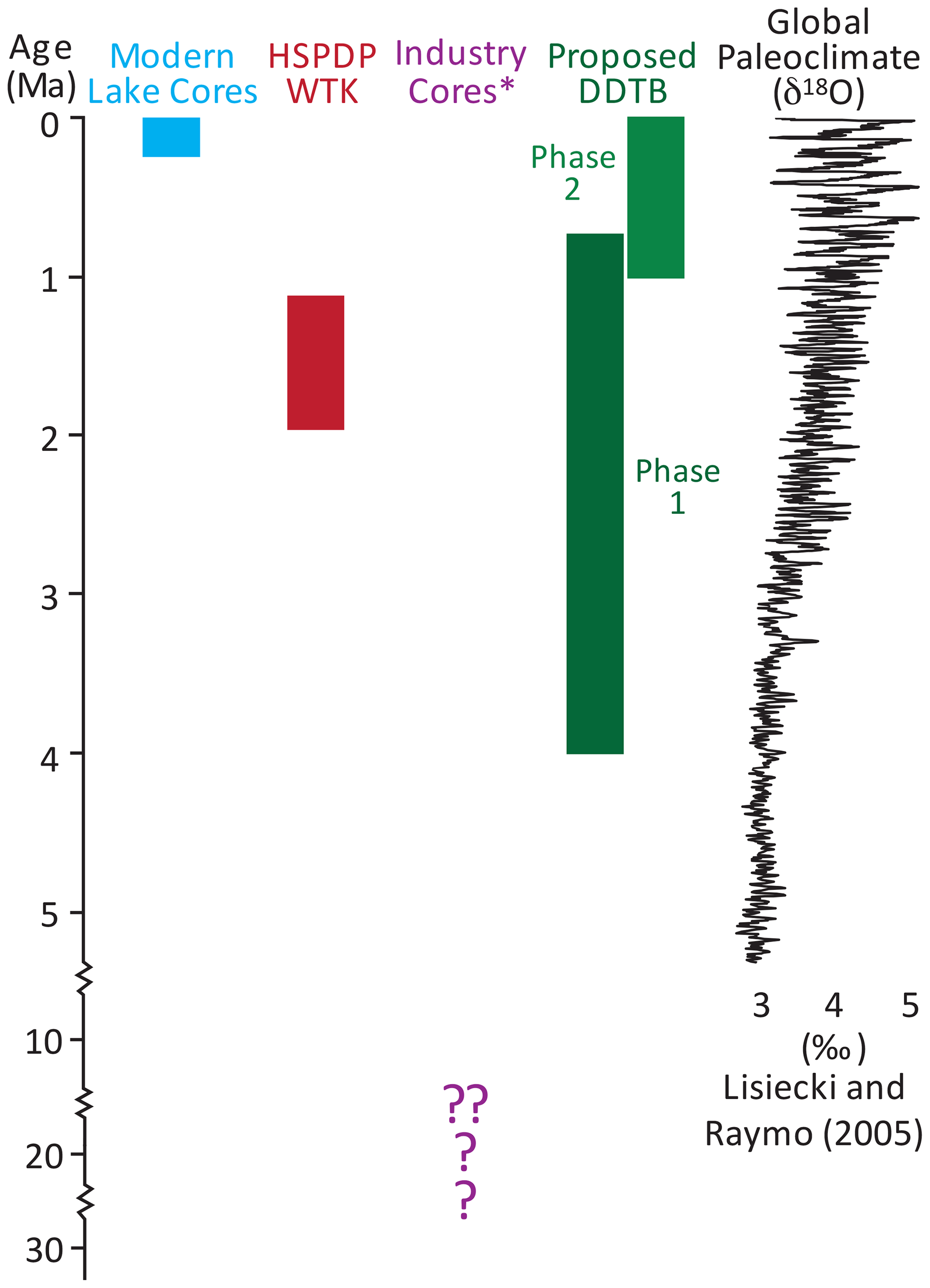
Figure 2Summary of time periods covered by existing cores from the Turkana Basin and those spanned by the proposed DDTB record plotted with the global paleoclimate benthic stack (Lisiecki and Raymo, 2005). The proposed DDTB record will fill significant gaps in the understanding of the continental paleoclimate response to global forcing in the Turkana Basin. ∗ Note that industry data are predominantly cuttings, not continuous core.
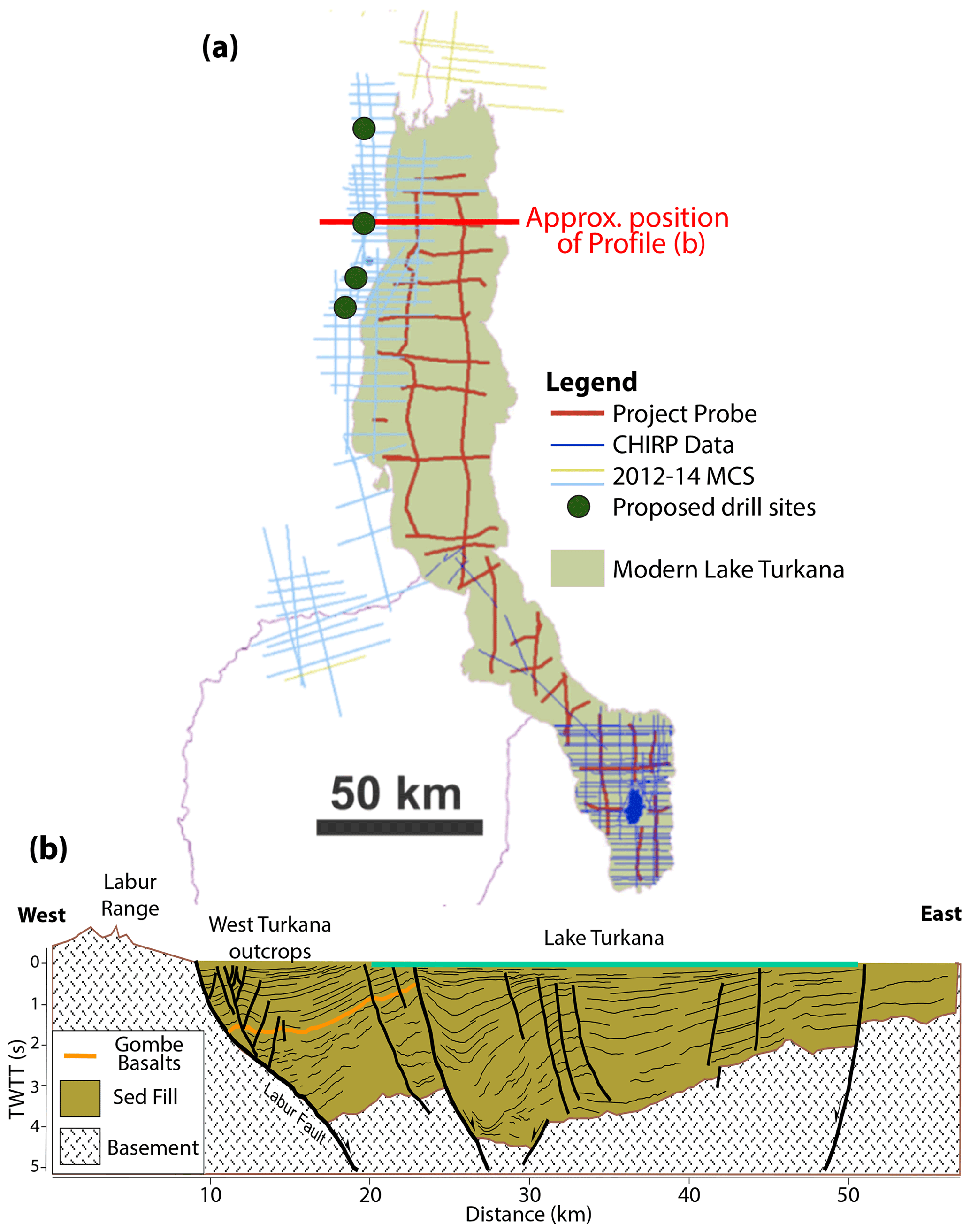
Figure 3(a) Outline of Lake Turkana with locations of available seismic reflection tracklines. Red lines denote legacy offshore multichannel seismic reflection profiles collected in 1984 by Project PROBE of Duke University. Dark-blue lines indicate high-resolution CHIRP seismic reflection profiles acquired by Syracuse University in 2009–2011. Light-blue lines are commercial seismic profiles acquired during hydrocarbon exploration in the Turkana Rift and include land, transition-zone, and offshore reflection data. (b) Interpreted seismic profile across the basin. Profile redrawn and simplified from Nutz et al. (2022). The targeted sequence for onshore drilling will exploit the West Turkana outcrop belt, with staggered holes extending down to ca. 4 Ma (Gombe Basalts).
Ultimately, only by returning to Turkana through the proposed Deep Drilling in the Turkana Basin project can the record of climate and landscape evolution be fully resolved (Fig. 2). By targeting a continuous 4 Myr of sediment, this project will enable us to minimize the complicating factors of both spatial variability and modification by modern soil forming processes inherent in using outcrops to reconstruct change through time.
For more than half a century the Turkana Basin has been central to our understanding of hominin evolution and cultural development in eastern Africa (Isaac and Isaac, 1997; Roche et al., 2004; Wood and Leakey, 2011). The extremely rich fossil assemblages spanning the Plio-Pleistocene include the earliest australopithecines from around 4 Ma; early examples of the Paranthropus lineage from ca. 2.5 Ma; and a diverse assemblage of early Homo fossils beginning prior to 2 Ma, including the nearly complete skeleton of Homo erectus, the Turkana Boy at 1.4 Ma. These hominin specimens are complemented by a suite of archaeological assemblages ranging from the earliest known stone tools at Lomekwi (3.3 Ma; Harmand et al., 2015); early Acheulean at Kokiselei (1.7 Ma; Lepre et al., 2011); and a wide variety of lithic traditions from Koobi Fora, the lower Omo Valley, and West Turkana. This unsurpassed record of early human development is associated with a huge collection of fossils representing the savanna community in the basin throughout the Plio-Pleistocene (Bobe, 2011). The entire record has been contextualized by complex sedimentary records from extensive outcrops (Brown and Feibel, 1991; Harris et al., 1988) and the limited coring efforts to date. Capping off the unique nature of the Turkana Basin record, the Plio-Pleistocene sequence is punctuated by abundant widespread tephra markers which can be geochemically correlated and many of which have associated radiometric dates (Brown et al., 2006). Thus the legacy of crucial discoveries in hominin evolution can be directly and precisely integrated with a high-resolution continuous core record and all of the signals of climatic drivers, tectonic effects, and landscape evolution we can extract from that sediment archive.
We convened a series of three events to solicit input on defining scientific priorities and strategies from the broader scientific community. With the repercussions of COVID still making travel complicated, particularly from certain countries/regions, and seeking to be as inclusive as possible even beyond those impacted by COVID restrictions, we opted to bracket our in-person workshop with online meetings. The online meetings enabled all interested applicants to initiate potential key discussions before the meeting, revise central themes right after the meeting, and also to incorporate team members who could not attend in-person, thereby expanding the participation base for DDTB.
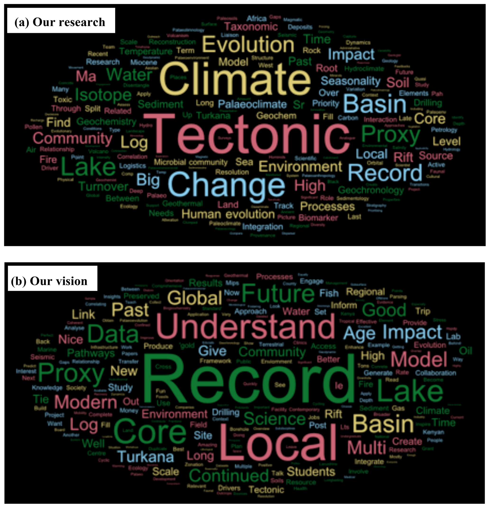
Figure 4Word clouds reflecting (a) the broad variety of scientific topics and expertise in the community represented during the ICDP workshop and (b) the aims of participants along the five key topics in the project applied to DDTB, namely (i) basin evolution; (ii) paleoclimate; (iii) paleoenvironment; (iv) modern systems; and (v) outreach, capacity building and education.
The in-person International Continental Scientific Drilling Program (ICDP) workshop was held in Nairobi, Kenya, between 11–14 July 2022. It was attended by 38 participants from nine countries, representing 30 institutions/organizations (universities, government agencies, and private sector, etc.) and the broad variety of research foci in the community (outlined in Fig. 4a). Of this group, 52 % of the participants were women, and 32 % were Kenyan. We discussed the unique opportunities for cutting-edge science offered by a long, continuous sedimentary core from Turkana Basin and developed hypotheses that can be advanced and tested only through long scientific drill cores. These hypotheses focus primarily on the ICDP theme of environmental change, but the community also engaged in discussion of georesources, specifically potable water, fisheries, and geothermal energy. Logistics and potential drill sites were discussed, as were technical requirements and strategies to prepare for full drilling and scientific funding proposals. The first day of the workshop began with presentations on the evolution of the paleoenvironment, paleoclimate, tectonics, and hominins as recorded in the Turkana Basin. The modern limnology and its relationship to ecosystems were also discussed. From there, we tasked participants with “dreaming big” (“our vision” in Fig. 4b) through a series of breakout activities to imagine what the ideal project and collaboration structure would look like from both a science and outreach perspective in order to make sure all perspectives and approaches were heard at this stage. This culminated in collecting feedback and compiling that feedback into clusters centered around emerging themes, both in terms of scientific goals but also broader impacts and project team structure (Fig. 4). The five major topics addressed by DDTB and worked on by breakout groups during the workshop were (i) basin evolution; (ii) paleoclimate; (iii) paleoenvironment; (iv) modern systems; and (v) outreach, capacity building and education. These thematic topics and the research questions that could be addressed through the strategic acquisition of deep scientific drill cores from Turkana Basin are discussed further in the following sections.
The in-person workshop in Nairobi also included an excursion to the National Museums of Kenya where we saw and learned more about the significant paleoanthropological finds that originated from the Turkana Basin. As centering the theme of environmental change around the rich hominin fossil record and associated ecosystems from the Turkana Basin is one of the unique elements of DDTB, seeing the actual fossils helped the team more fully develop the linkages between the disciplines of paleoanthropology and the geosciences.
4.1 Drilling plan
The goal of DDTB is to drill a continuous, high-resolution sedimentary record from the Pliocene to present (4–0 Ma) through strata of the Omo Group (Plio-Pleistocene) and Turkana Group (Late Quaternary). Sediment accumulation rates in the basin are spatially variable but average 15 cm kyr−1, up to 100 cm kyr−1, in thickened sequences on shore (Feibel, 1988) and more than 1 m kyr−1 in offshore Late Quaternary cores (Morrissey and Scholz, 2014). We will target the thicker packages as interpreted from seismic data, while avoiding settings prone to discontinuities and sedimentary gaps. Based on comparative composite sections from outcrop (Feibel, 2011) and the newly acquired industry seismic reflection data (Fig. 3), a ∼ 1500 m composite core length is required to recover this interval. From our DDTB scientific workshop, we developed a two-phase drilling plan to recover the sedimentary record from 4 Ma to present from the Turkana Basin. Phase 1 of DDTB is focused on the time interval from 4 to < 0.7 Ma from an on-land offset drilling transect of cores along the northwestern edge of modern Lake Turkana (Fig. 1). This transect will sample the full sedimentary section of the Turkana Basin and enable the team to apply a multi-proxy approach to reconstructing the paleoenvironment, paleovegetation, and paleoclimate during a period of great diversity in hominins. Because much of this interval is also exposed in weathered outcrops which yield fossils and archaeology, we will be able to directly tie the proposed high-resolution proxy records in with known paleoanthropological sites. This will be achieved through a sequence of four single- or double-cored ∼ 400 m holes, positioned youngest to oldest from north to south (Fig. 1b). This transect will enable the project to recover this interval most cost-effectively by minimizing operational costs, as smaller rigs, shallower boreholes, and industry-standard coring tools will allow recovery of a complete sequence in offset locations. The project will leverage the experience from HSPDP in 2013 (Cohen et al., 2016) to design a drilling program with significantly improved likelihood of success. This approach avoids major cost increases associated with the engineering and operational requirements to drill fewer, deeper boreholes and the potential for compromised core datasets due to high geothermal gradients in this region. Long seismic reflection survey lines along structural strike provide the basis for determining the depth needed at each location to yield the overlap in core sequences for correlation and integration. The team will leverage the well-documented tephrostratigraphic record from Turkana (Brown and McDougall, 2011) and multi-proxy core scanning data to correlate this transect of cores into a synthetic record that ties tightly with the archaeological and paleoanthropological record from the Turkana Basin.
Phase 2 of DDTB targets the most recent ∼ 1 Myr of sediment from a core drilled in modern Lake Turkana that extends to the present day (Fig. 1b) and provides a ∼ 300 kyr overlap with the land based record from Phase I of DDTB to ensure a continuous record when the drill cores from both phases are combined. This record will provide a hitherto unseen look into the Turkana Basin during the interval of time from ∼ 700–20 kyr which is rarely exposed in outcrops from the Kenyan sedimentary record (McDougall et al., 2008; Manthi et al., 2018). We know very little about what the Turkana Basin looked like (including fundamental questions like whether a lake was present) for this key corridor of hominin migration and the evolution of Homo sapiens (Cohen et al., 2022; Foerster et al., 2022). A record of the past million years from Turkana will also create opportunities to incorporate this critical region into broader Afro-Syrian Rift synthesis, leveraging a wealth of data from other completed and planned ICDP projects. Phase 2 will be accomplished through drilling at one or more sites double- or triple-cored to ∼ 400–500 m sediment depth, positioned in the Central Basin of Lake Turkana in 20–60 m water depth, using drilling tools and protocols proven in numerous past ICDP lake drilling campaigns. Both legacy and new seismic reflection data from industry, including continuous onshore-offshore lines (Fig. 3), confirm the continuity of subsurface units and provide confidence that the stratigraphy can be correlated between these locations to allow a complete sequence to be developed most effectively through an offset drilling program.
4.2 Scientific agenda
Continental drilling for core retrieval is essential in the Turkana Basin in order to advance the state of the science, particularly to constrain the paleoenvironmental and paleoclimatic context in which our hominin ancestors survived and thrived. But a composite deep drill core located in Turkana Basin would also give insight into other key topics identified by the PI team and workshop participants, including basin evolution, tectonics, and magmatism. Through the proposed drilling plan, we seek to pursue a series of research topics and hypotheses related to the thematic breakout groups formed through the online and in-person meetings. A summary of the key take-home messages from these workshop discussions is summarized in the sections that follow.
4.2.1 Basin evolution
The basin evolution breakout group focused on how DDTB could contribute to constraining the interplay between tectonics, magmatism, and climate in continental rift systems. The Turkana Basin, with its magmatically active system and early onset of rifting, is an ideal location to integrate studies of eruptive history with sedimentary and structural archives of basin evolution. Recent modeling and field studies reveal that surface processes, including erosion and sediment and water column loading, can impact rates and styles of extensional deformation in rifts, as well as magma body inflation and deflation (Albino et al., 2010; Sternai, 2020; Egger et al., 2021; Xue et al., 2023). Utilizing only shallow sedimentary cores, critical feedbacks between the magmatic, tectonic, hydrologic, and sedimentary systems have been revealed on 1000- to 10 000-year timescales (Muirhead and Scholz, 2017); however, a rich (> 1 Myr) and first-of-its-kind history of the feedbacks between these key processes operating at continental rifts can only be obtained through a deep drilling project. Key to this story would be compiling data from both Phase 1 and Phase 2 of this project as both offer unique but independent opportunities to synthesize the proposed DDTB record with existing structural data. To achieve these objectives, the project would undertake facies analysis and provenance studies, which could be used to reconstruct basin extension, paleoenvironment evolution, and eruptive history. Results from the core would be spatially integrated using core–seismic outcrop integration, which can allow reconstruction of the temporal history of fault slip through careful mapping of displaced seismic horizons of known age (e.g., Wright et al., 2023). By comparing the interpreted fault slip history with the ∼ 4 Myr chronology of volcanism and lake-level change revealed by the deep drilling record, we can explore how climate-driven hydrological changes in the region have influenced the structural development of the basin. Ultimately, this would enable DDTB to constrain the critical feedbacks between the tectonic, magmatic, climatic, and hydrologic processes that have driven the Plio-Pleistocene evolution of ecosystems in the Turkana Basin.
4.2.2 Paleoclimate
The paleoclimate breakout group focused on the potential scientific advances that could be achieved from a 4 Myr record from the Turkana Basin. Much of our current understanding of eastern African climate for this time comes from outcrops, providing snapshots of climate variability, and nearby marine sediment cores (deMenocal, 1995). While marine drill cores are more continuous, questions remain about how well these distal archives actually reconstruct conditions in continental settings (Cohen et al., 2016). Continuous Pliocene to present records of proxy-derived paleoclimate from eastern Africa would be the first of their kind, with resolution and continuity currently unavailable from a single region in Africa. The ability to reconstruct the regional climate for the last 4 Myr would allow us to better frame the environmental changes underway both across the landscape and within the lake itself. These records of climate variability, obtained directly for the region where the fossil record is one of the richest, would also provide context for hominin evolution. This new record would provide a continental signal of tropical climate variability from northern hemispheric eastern Africa. The proposed DDTB record could be directly compared to marine records (e.g., Castañeda et al., 2016; Taylor et al., 2021), existing southern hemispheric continental paleoclimate records spanning the last ∼ 1.4 Ma (e.g., Lake Malawi; Scholz et al., 2007; Lyons et al., 2015; Johnson et al., 2016), and/or other southern hemispheric continental records proposed to ICDP (e.g., ∼ 10 Ma to modern from Lake Tanganyika; Russell et al., 2020). We will examine spatiotemporal coherence of eastern and southern African climate change through quantitative comparisons of the Turkana Basin drill cores with these other records. New sedimentary records produced through deep-drilling will span important Plio-Pleistocene global climate changes and allow us to examine how these events shaped the paleoenvironment. By examining the amount and degree of climatic variability in the region and how sensitive the Turkana Basin is to global climate events including glaciation, circulation changes, and oceanic gateway changes in a high CO2 world, we can provide important Pliocene climate model constraints.
4.2.3 Paleoenvironment and impacts of paleoecology
An understanding of eastern African paleoenvironmental changes during the last 4 Myr would enable the scientific community to tackle key questions on the ecological structure through time, including the tempo and mode of change. The breakout group on paleoenvironments emphasized that this would be crucial to finally understand more about eastern African habitat transformations and how these might have been associated with the rate of evolutionary change. The unique location of Lake Turkana within the EARS would facilitate parsing the impacts of tectonic versus climatic drivers and extend the knowledge on the role that basin evolution might have played in reaching milestones in faunal evolution. Environmental reconstruction could be achieved through a multi-proxy approach including but not limited to diatoms, invertebrate fossils (ostracods, molluscs, etc.), pollen, phytoliths, paleosol-based proxies, and organic compound-specific stable isotope records, all of which have comparable records both from HSPDP and outcrop-based studies (Brown and Feibel, 1991). Although numerous significant fragments of this story are available (e.g., Yost et al., 2021), the discontinuity of these records in space and time complicates the ability to parse the impacts of climate from those of tectonic drivers on paleoenvironments and their associated ecosystems. Those gaps could finally be filled by the DDTB record, and, moreover, a continuous paleoenvironmental record from the Turkana Basin would offer the unique opportunity to directly tie in with the robust paleontological, paleoanthropological, and archaeological record in the Turkana Basin. It also creates opportunities to compare with other basins across the African continent, leveraging the work from other ICDP projects, both completed (e.g., Lake Bosumtwi (Koeberl et al., 2005), Lake Malawi (Scholz et al., 2011), and HSPDP (Cohen et al., 2016)) and proposed (e.g., Lake Tanganyika (Russell et al., 2020), Lake Victoria (Berke et al., 2024), and Afar Dallol Drilling (Foubert et al., 2021)).
4.2.4 Modern systems
The modern lake systems' breakout group focused on the activities and changes that have recently occurred in Lake Turkana driven by anthropogenic activities on the lake and its catchments and by natural climate variability. The group recognized that a robust understanding of the modern lake system is key to understanding responses in paleo-proxy records. The modern lake is experiencing pressure from the catchment that directly impacts the hydrochemistry and water influx. This transboundary lake has its main source of inflow coming from the Ethiopian highlands via the Omo River, and thus activities such as the recent construction of hydroelectric dams (e.g., Gibe Dam series) on the Omo River perturb the annual cycle of sediments and nutrient input into the lake and flood regimes. There are a number of data gaps and unknowns within the modern systems that need monitoring, including in situ lake level and evaporation monitoring, river level and physicochemical parameter monitoring, groundwater monitoring, and monitoring of the climatic parameters (winds, solar insolation, rainfall, humidity) at different elevation within the catchments. The team is actively working to address these gaps by working in close conjunction with local partners including colleagues at the Kenyan Marine and Fisheries Research Institution, Earth Observation Systems (satellites), and accessing wind data from The Trans-African Hydro-Meteorological Observatory (van de Giesen et al., 2014). Collaboration with colleagues focused on the fact that the modern system serves two significant purposes. The first is leveraging this partnership to advance our mutual research interests. The second, extremely significant, opportunity here is to collaborate to successfully design and implement Phase 2 of the DDTB. We continue to work on integrating modern climate, hydrology, and limnological data in ways that inform the reconstruction of the past climates, environments, and ecosystems, as well as the resource focus of this project.
4.2.5 Outreach, capacity building, and education
The workshop was structured to maximize input from all participants, regardless of their area of expertise, career stage, or role on the team. In this way all participant perspectives were heard, and their feedback was documented. Centering our working groups around emerging themes co-created with the workshop participants cultivated new interpersonal connections that resulted in a sense of shared responsibility toward broader impacts. This intentionality opened the door for discussions around the societal impact of coring and drilling work such as the critical role of water in community social structure.
With this foundation, ongoing development of strategies for outreach, education, and capacity building has been facilitated by the US Continental Scientific Drilling Facility's Science and Outreach Coordinator, Kat Cantner, with community partners through the Turkana Basin Institute, Kenya. Access to water is essential for drilling operations. There is also a direct connection between water access and girls' education since girls are responsible for transporting water to the household. Girls are prevented from attending school if water is not readily available since they must spend many hours supplying the home. Stigma around menstruation and lack of universal support for women's education are also a challenge in local communities. Based on assessment of need and interest through partnership with the Turkana Basin Institute, we proposed funding outreach to communities regarding the value of girls' education, providing sanitary products for girls (where not already covered by national programs) and sponsoring local students. The project team will co-create science content and educational activities for the Turkana Basin Institute's student science clubs and will also generate age-appropriate material for primary-, secondary-, and university-age learners to increase awareness of geoscience career opportunities and build capacity for a stronger geoscience workforce. The international drilling campaign and subsequent research also offer opportunities to support future capacity building, particularly for Kenyan students. The implementation of well-established concepts like international summer school provides unique synergies and networking opportunities for both experienced scientists involved and future generations of scientists and students (e.g., Wiersberg et al., 2021). The involvement of international experts with a range of expertise around scientific drilling, being both on-site for several weeks and/or in close dialogue with cooperating institutions (e.g., universities, national museum, industry), also offers a unique opportunity for interdisciplinary knowledge transfer and hands-on experience across disciplines and national borders.
Based on the need to expand understanding of the tectonic, climatic, and biologic evolution in eastern Africa and the opportunities to leverage collaboration between research and industry (fisheries and geothermal), we recommend a two-phase drilling campaign to recover a continuous sedimentary record from the Turkana Basin extending from 4 Ma to present. We propose that Phase 1 will recover an on-shore transect of cores along the northwestern margin of Lake Turkana spanning the interval from 4 to 0.7 Ma, expanding upon the success for the WTK13 drill core drilled as part of HSPDP. Phase 2 of the DDTB project will focus on the record from 1 Ma to modern, and targeting the Central Basin of Lake Turkana. DDTB will leverage existing outcrop research from the Turkana Basin and regional lacustrine cores. When combined, the two phases of this unprecedented record will enable researchers to parse the relative impacts of tectonics, volcanism, and climate on biological and ecological evolution, including the physical and cultural origins of our own ancestors.
No datasets were used in this article.
In addition to the named co-authors on this paper, the following individuals make up the Deep Drilling in the Turkana Basin (DDTB) project team through their participation in the meetings that shaped this project. This team contributed to the ideas presented in this workshop report: Meshack Owira Amimo (Water Resources Authority, Nairobi, Kenya), Omondi Everlyne Apondi (University of Albany, Albany, NY, USA), Christopher Campisano (Arizona State University, Tempe, AZ, USA), Patrick Gathogo (Stony Brook University, Stony Brook, NY, USA), John Greenlee (Syracuse University, Syracuse, NY, USA), Sonia Harmand (CRNS, Paris, France), Annett Junginger (University of Tübingen, Tübingen, Germany), Benjamin Keenan (McGill University, Montreal, Canada), James Last Keyombe (Kenya Marine and Fisheries Institute, Kisumu, Kenya), Rahab Kinyanjui (National Museums of Kenya, Nairobi, Kenya; Max Planck Institute for Geoanthropology, Jena, Germany), Simon Kübler (Ludwig Maximilian University Munich, Munich, Germany), Rachel Lupien (Aarhus University, Aarhus, Denmark), John Malala (Kenya Marine and Fisheries Institute, Kalokol, Kenya), Fredrick Kyalo Manthi (National Museums of Kenya, Nairobi, Kenya), Marta Marchegiano (University of Granada, Granada, Spain), Inka Meyer (Ghent University, Ghent, Belgium), Veronica Muiruri (National Museums of Kenya, Nairobi, Kenya), Dennis Njagi (Dedan Kimathi University, Nyeri, Kenya), Julian Ogondo (Maseno University, Kisumu, Kenya), Samson Omondi (Water Resources Authority, Nairobi, Kenya), Ayan Hassan Omar (National Oil Corporation of Kenya, Nairobi, Kenya), Christina Omuombo (University of Nairobi and Technical University of Kenya, Nairobi, Kenya), Simona Pierdominici (GFZ-Potsdam, Potsdam, Germany), Robert Raynolds (Denver Natural History Museum, Denver, CO, USA), Carolina Rosca (Andalusian Institute of Earth Sciences (IACT – CSIC), Granada, Spain), Christian Rowan (Lamont-Doherty Earth Observatory, Palisades, NY, USA), Sara Shedroff (University of Massachussetts, Amherst, MA, USA), Andrew Steen (University of Tennessee, Knoxville, TN, USA), Jeroen van der Lubbe (Vrije Universiteit Amsterdam, Amsterdam, the Netherlands), Thomas Wiersberg (ICDP, Potsdam, Germany), Marcella Winget (Hamilton College, Clinton, NY, USA), and Christian Zeeden (Leibniz Institute for Applied Geophysics, Hanover, Germany).
CCB, MB, KC, CSF, VF, AN, LO, HMR, and CAS organized the workshop and co-facilitated it. CCB was lead author for the workshop report with significant contributions from co-authors MB, KC, CSF, VF, GMK, JM, AN, LO, HMR, and CAS. The content of this report was generated by the whole DDTB project team and participants from two online meets which complemented the in-person workshop.
The contact author has declared that none of the authors has any competing interests.
Publisher’s note: Copernicus Publications remains neutral with regard to jurisdictional claims made in the text, published maps, institutional affiliations, or any other geographical representation in this paper. While Copernicus Publications makes every effort to include appropriate place names, the final responsibility lies with the authors.
We recognize the collaboration of the Geothermal Development Company (GDC) and the National Museums of Kenya during the workshop. We acknowledge the contributions from the National Oil Corporation of Kenya; the Turkana Basin Institute; Africa Oil; and the late Isaiah Nengo (Turkana Basin Institute, Kenya, and Stony Brook University, USA), who facilitated the transfer of industry seismic data that support the site selection. Thanks are expressed to Christian Rowan (Lamont-Doherty Earth Observatory, USA) for his efforts on seismic interpretation and site selection.
This research has been supported by the NSF-funded Research Coordination Network EarthRates (which funded the initial 2017 planning workshop leading to the creation of DDTB) and the International Continental Scientific Drilling Program (ICDP) which funded the 2022 workshop in Nairobi.
This paper was edited by Ulrich Harms and reviewed by Thomas Wagner and one anonymous referee.
Albino, F., Pinel, V., and Sigmundsson, F.: Influence of surface load variations on eruption likelihood: application to two Icelandic subglacial volcanoes, Grímsvötn and Katla, Geophys. J. Int., 181, 1510–1524, https://doi.org/10.1111/j.1365-246X.2010.04603.x, 2010.
Avery, S.: Hydrological impacts of Ethiopia's Omo Basin on Kenya's Lake Turkana water levels & fisheries, African Development Bank Group, https://www.afdb.org/fileadmin/uploads/afdb/Documents/Compliance-Review/REPORT_NOV_2010_S_AVERY_TURKANA_Small_file.pdf (last access: 5 December 2023), 2010.
Avery, S. and Eng, C.: Lake Turkana & the Lower Omo: hydrological impacts of major dam and irrigation developments, African Studies Centre, the University of Oxford, 2012.
Baker, B. H. and Wohlenberg, J.: Structure and evolution of the Kenya rift valley, Nature, 229, 538–542, https://doi.org/10.1038/229538a0, 1971.
Bayley, P. B.: The Commercial Fishery of Lake Turkana, in: Report on the Findings of the Lake Turkana Project, 1972–75, edited by: Hopson, A. J., 2, 351–554, 1982.
Beck, C. C.: The terrestrial climate record from the Turkana Basin, Kenya: a multiproxy approach, PhD dissertation, Rutgers University, USA, 170 pp., https://doi.org/10.7282/T3ZS2ZGB, 2015.
Beck, C. C., Feibel, C. S., Lupien, R., Yost, C. L., Rucina, S., Russell, J. M., Deino, A., Sier, M., Cohen, A. S., and Campisano, C. J.: Paleoenvironmental change as seen from a multiproxy perspective in the West Turkana Kaitio core (WTK13), Kenya, AGU Annual Meeting, 11–15 December 2017, New Orleans, LA, USA, https://agu.confex.com/agu/fm17/meetingapp.cgi/Paper/292581 (last access: 5 December 2023), 2017.
Beck, C. C., Feibel, C. S., Mortlock, R. A., Quinn, R. L., and Wright, J. D.: Little Ice Age to modern lake-level fluctuations from Ferguson's Gulf, Lake Turkana, Kenya, based on sedimentology and ostracod assemblages, Quaternary Res., 101, 129–142, https://doi.org/10.1017/qua.2020.105, 2021.
Bergström, A., Stringer, C., Hajdinjak, M., Scerri, E. M. L., and Skoglund, P.: Origins of modern human ancestry, Nature 590, 229–237, https://doi.org/10.1038/s41586-021-03244-5, 2021.
Berke, M. A., Johnson, T. C., Werne, J. P., Grice, K., Schouten, S., and Damsté, J. S. S.: Molecular records of climate variability and vegetation response since the Late Pleistocene in the Lake Victoria basin, East Africa, Quaternary Sci. Rev., 55, 59–74, https://doi.org/10.1016/j.quascirev.2012.08.014, 2012.
Berke, M. A., Peppe, D. J., and the LVDP team: ICDP workshop on the Lake Victoria Drilling Project (LVDP): scientific drilling of the world's largest tropical lake, Sci. Dril., 33, 21–31, https://doi.org/10.5194/sd-33-21-2024, 2024.
Bloomer, S. H., Curtis, P. C., and Karson, J. A.: Geochemical variation of Quaternary basaltic volcanics in the Turkana Rift, northern Kenya, J. Afr. Earth Sci., 8, 511–532, 1989.
Bobe, R.: Fossil mammals and paleoenvironments in the Omo-Turkana Basin, Evol. Anthropol., 20, 254–263, https://doi.org/10.1002/evan.20330, 2011.
Boone, S. C., Seiler, C., Kohn, B. P., Gleadow, A. J. W., Foster, D. A., and Chung, L.: Influence of Rift Superposition on Lithospheric Response to East African Rift System Extension: Lapur Range, Turkana, Kenya, Tectonics, 37, 182–207, https://doi.org/10.1002/2017TC004575, 2018a.
Boone, S. C., Kohn, B. P., Gleadow, A. J., Morley, C. K., Seiler, C., Foster, D. A., and Chung, L.: Tectono-thermal evolution of a long-lived segment of the East African Rift System: Thermochronological insights from the North Lokichar Basin, Turkana, Kenya, Tectonophysics, 744, 23–46, https://doi.org/10.1016/j.tecto.2018.06.010, 2018b.
Brown, F. H. and Feibel, C. S.: Stratigraphy, depositional environments and paleogeography of the Koobi Fora Formation, in: Koobi Fora Research Project, Volume 3. Stratigraphy, artiodactyls and paleoenvironments, edited by: Harris, J. M., Clarendon Press, Oxford, UK, 1–30, https://doi.org/10.1093/oso/9780198573999.003.0001, 1991.
Brown, F. H. and McDougall, I.: Geochronology of the Turkana depression of northern Kenya and southern Ethiopia, Evol. Anthropol., 20, 217–227, https://doi.org/10.1002/evan.20318, 2011.
Brown, F. H., Haileab, B., and McDougall, I.: Sequence of tuffs between the KBS Tuff and the Chari Tuff in the Turkana Basin, Kenya and Ethiopia, J. Geol. Soc. Lond., 163, 185–204, https://doi.org/10.1144/0016-764904-165, 2006.
Bruhn, R. L., Brown, F. H., Gathogo, P. N., and Haileab, B.: Pliocene volcano-tectonics and paleogeography of the Turkana Basin, Kenya and Ethiopia, J. Afr. Earth Sci., 59, 295–312, https://doi.org/10.1016/j.jafrearsci.2010.12.002, 2011.
Campisano, C. J., Cohen, A. S., Arrowsmith, J. R., Asrat, A., Behrensmeyer, A. K., Brown, E. T., Deino, A. L., Deocampo, D. M., Feibel, C. S., Kingston, J. D., Lamb, H. F., Lowenstein, T. K., Noren, A., Olago, D. O., Owen, R. B., Pelletier, J. D., Potts, R., Reed, K. E., Renaut, R. W., Russell, J. M., Russell, J. L., Schäbitz, F., Stone, J. R., Trauth, M. H., and Wynn, J. G.: The Hominin Sites and Paleolakes Drilling Project: high-resolution paleoclimate records from the East African Rift System and their implications for understanding the environmental context of hominin evolution, PaleoAnthropology, 2017, 1–43, https://doi.org/10.4207/PA.2017.ART104, 2017.
Castañeda, I. S., Caley, T., Dupont, L., Kim, J. H., Malaizé, B., and Schouten, S.: Middle to Late Pleistocene vegetation and climate change in subtropical southern East Africa, Earth Planet. Sci. Lett., 450, 306-316, https://doi.org/10.1016/j.epsl.2016.06.049, 2016.
Cerling, T. E. and Powers, D. W.: Paleorifting between the Gregory and Ethiopian rifts, Geology, 5, 441–444, https://doi.org/10.1130/0091-7613(1977)5<441:PBTGAE>2.0.CO;2,1977.
Cohen, A., Campisano, C., Arrowsmith, R., Asrat, A., Behrensmeyer, A. K., Deino, A., Feibel, C., Hill, A., Johnson, R., Kingston, J., Lamb, H., Lowenstein, T., Noren, A., Olago, D., Owen, R. B., Potts, R., Reed, K., Renaut, R., Schäbitz, F., Tiercelin, J.-J., Trauth, M. H., Wynn, J., Ivory, S., Brady, K., O'Grady, R., Rodysill, J., Githiri, J., Russell, J., Foerster, V., Dommain, R., Rucina, S., Deocampo, D., Russell, J., Billingsley, A., Beck, C., Dorenbeck, G., Dullo, L., Feary, D., Garello, D., Gromig, R., Johnson, T., Junginger, A., Karanja, M., Kimburi, E., Mbuthia, A., McCartney, T., McNulty, E., Muiruri, V., Nambiro, E., Negash, E. W., Njagi, D., Wilson, J. N., Rabideaux, N., Raub, T., Sier, M. J., Smith, P., Urban, J., Warren, M., Yadeta, M., Yost, C., and Zinaye, B.: The Hominin Sites and Paleolakes Drilling Project: inferring the environmental context of human evolution from eastern African rift lake deposits, Sci. Dril., 21, 1–16, https://doi.org/10.5194/sd-21-1-2016, 2016.
Cohen, A. S., Stone, J., Beuning, K., Park, L., Reinthal, P., Dettman, D., Scholz, C. A., Johnson, T., King, J. W., Talbot, M., Brown, E., and Ivory, S.: Ecological Consequences of Early Late-Pleistocene Megadroughts in Tropical Africa, P. Natl. Acad. Sci. USA, 104, 16422–16427, https://doi.org/10.1073/pnas.0703873104, 2007.
Cohen, A. S., Campisano, C. J., Arrowsmith, J. R., Asrat, A., Beck, C. C., Behrensmeyer, A. K., Deino, A.L., Feibel, C.S., Foerster, V., Kingston, J. D., Lamb, H. F., LOwenstein, T. K., Lupien, R. L., Muiruri, V., Olago, D. O., Owen, R. B., Potts, R., Russel, J. M., Schaebitz, F., Stone, J. R., Trauth, M. H., and Yost, C. L.: Reconstructing the Environmental Context of Human Origins in Eastern Africa Through Scientific Drilling, Annu. Rev. Earth Pl. Sc., 50, 451–476, https://doi.org/10.1146/annurev-earth-031920-081947, 2022.
Corti, G.: Continental rift evolution: from rift initiation to incipient break-up in the Main Ethiopian Rift, East Africa, Earth-Sci. Rev., 96, 1–53, https://doi.org/10.1016/j.earscirev.2009.06.005, 2009.
deMenocal, P. B.: Plio-Pleistocene African Climate, Science, 270, 53–59, https://doi.org/10.1126/science.270.5233.53, 1995.
deMenocal, P. B.: Climate and human evolution, Science, 331, 540–542, https://doi.org/10.1126/science.1190683, 2011.
Dunkelman, T. J., Rosendahl, B. R., and Karson, J. A.: Structure and stratigraphy of the Turkana rift from seismic reflection data, J. Afr. Earth Sci., 8, 489–510, https://doi.org/10.1016/S0899-5362(89)80041-7, 1989.
Dunkley, P. N., Smith, M., Allen, D. J., and Darling, W. G.: The geothermal activity of the northern sector of the Kenya Rift Valley, British Geological Survey, Research Report no. SC/93/1, 185, https://nora.nerc.ac.uk/id/eprint/507920 (last access: 15 December 2023), 1993.
Ebinger, C. J. and Casey, M.: Continental breakup in magmatic provinces: An Ethiopian example, Geology, 29, 527–530, https://doi.org/10.1130/0091-7613(2001)029<0527:CBIMPA>2.0.CO;2, 2001.
Ebinger, C. J., Jackson, J. A., Foster, A. N., and Hayward, N. J.: Extensional basin geometry and the elastic lithosphere, Philos. T. Roy. Soc. A, 357, 741–765, https://doi.org/10.1098/rsta.1999.0351, 1999.
Egger, A. E., Ibarra, D. E., Weldon, R., Langridge, R. M., Marion, B., and Hall, J.: Influence of pluvial lake cycles on earthquake recurrence in the northwestern Basin and Range, USA, in: From Saline to Freshwater: The Diversity of Western Lakes in Space and Time, edited by: Starratt, S. W. and, Rosen, M. R., Geol. Soc America Special Paper 536, https://doi.org/10.1130/2018.2536(07), 2021.
Faith, J. T., Du, A., Behrensmeyer, A. K., Davies, B., Patterson, D. B., Rowan, J., and Wood, B.: Rethinking the ecological drivers of hominin evolution, Trends Ecol. Evol., 36, 797–807, https://doi.org/10.1016/j.tree.2021.04.011, 2021.
Feibel, C. S.: Paleoenvironments of the Koobi Fora Formation, Turkana Basin, northern Kenya, PhD dissertation, University of Utah, USA, 330 pp., 1988.
Feibel, C. S.: Freshwater stingrays from the Plio-Pleistocene of the Turkana Basin, Kenya and Ethiopia, Lethaia, 26, 359–366, https://doi.org/10.1111/j.1502-3931.1993.tb01542.x, 1994.
Feibel, C. S.: A geological history of the Turkana Basin, Evol. Anthropol., 20, 206–216, https://doi.org/10.1002/evan.20331, 2011.
Feibel, C. S., Beck, C. C., Lupien, R., Russell, J. M., Deino, A., Sier, M. J., Campisano, C., and Cohen, A. S.: Environmental dynamics on an Early Pleistocene lake margin: the WTK13 core at Kaitio, West Turkana, Kenya, Geological Society of America, Abstracts with Programs, Volume 49, No. 6,https://gsa.confex.com/gsa/2017AM/webprogram/Paper303947.html (last access: 5 December 2023), 2017.
Foerster, V., Asrat, A., Bronk Ramsey, C., Brown, E. T., Chapot, M. S., Deino, A., Duesing, W., Grove, M., Hahn, A., Junginger, A., Kaboth-Bahr, S., Lane, C. S., Opitz, S., Noren, A., Roberts, H. M., Stockhecke, M., Tiedemann, R., Vidal, C. M., Vogelsang, R., Cohen, A. S., Lamb, H. F., Schaebitz, F., and Trauth, M. H.: Pleistocene climate variability in eastern Africa influenced hominin evolution, Nat. Geosci., 15, 805–811, https://doi.org/10.1038/s41561-022-01032-y, 2022.
Foster, D. A. and Gleadow, A. J.: Structural framework and denudation history of the flanks of the Kenya and Anza Rifts, East Africa, Tectonics, 15, 258–271, https://doi.org/10.1029/95TC02744, 1996.
Foubert, A., Kidane, T., Keir, D., Atnafu, B., and ADD-ON Team, T. I.: Afar Dallol Drilling – ONset of sedimentary processes in an active rift basin (ADD-ON): Scientific drilling targets in the Afar (Ethiopia), EGU General Assembly 2021, online, 19–30 Apr 2021, EGU21-14486, https://doi.org/10.5194/egusphere-egu21-14486, 2021.
Furman, T., Bryce, J. G., Karson, J., and Iotti, A.: East African Rift System (EARS) plume structure: insights from Quaternary mafic lavas of Turkana, Kenya, J. Petrol., 45, 1069–1088, https://doi.org/10.1093/petrology/egh004, 2004.
Furman, T., Kaleta, K. M., Bryce, J. G., and Hanan, B. B.: Tertiary Mafic Lavas of Turkana, Kenya: Constraints on East African Plume Structure and the Occurrence of High-μ Volcanism in Africa, J. Petrol., 47, 1221–1244, https://doi.org/10.1093/petrology/egl009, 2006.
Gownaris, N. J., Pikitch, E. K., Ojwang, W. O., Michener, R., and Kaufman, L.: Predicting species' vulnerability in a massively perturbed system: the fishes of Lake Turkana, Kenya, PLoS One, 10, 1–24, https://doi.org/10.1371/journal.pone.0127027, 2015.
Gramling, C.: Kenyan find heralds new era in water prospecting, Science, 341, 1327, https://doi.org/10.1126/science.341.6152.1327, 2013.
Haileab, B., Brown, F. H., McDougall, I., and Gathogo, P. N.: Gombe Group basalts and initiation of Pliocene deposition in the Turkana depression, northern Kenya and southern Ethiopia, Geol. Mag., 141, 41–53, https://doi.org/10.1017/S001675680300815X, 2004.
Halfman, J. D., Johnson, T. C., and Finney, B. P.: New AMS dates, stratigraphic correlations and decadal climatic cycles for the past 4 Ka at Lake Turkana, Kenya, Palaeogeogr. Palaeocl. Palaeoecol, 111, 83–98, https://doi.org/10.1016/0031-0182(94)90349-2, 1994.
Hargrave, J. E., Hicks, M. K., and Scholz, C. A.: Lacustrine Carbonates From Lake Turkana, Kenya: A Depositional Model of Carbonates in an Extensional Basin, J. Sediment. Res., 84, 224–237, https://doi.org/10.2110/jsr.2014.22, 2014.
Harmand, S., Lewis, J. E., Feibel, C. S., Lepre, C. J., Prat, S., Lenoble, A., Boes, X., Quinn, R. L., Brenet, M., Arroyo, A., Taylor, N., Clement, S., Daver, G., Brugal, J. P., Leakey, L., Mortlock, R. A., Wright, J. D., Lokorodi, S., Kirwa, C., Kent, D. V., and Roche, H.: 3.3-million-year-old stone tools from Lomekwi 3, West Turkana, Kenya, Nature, 521, 310–315, https://doi.org/10.1038/nature14464, 2015.
Harris, J. M., Brown, F. H., and Leakey, M. G.: Geology and paleontology of Plio-Pleistocene localities west of Lake Turkana, Kenya, Contributions in Science, 399, 1–128, 1988.
Hopson, A. J. (Ed.): Lake Turkana: a report on the findings of the Lake Turkana Project 1972–1975, Overseas Development Administration, https://doi.org/10.5962/bhl.title.137758, 1982.
IPCC: Mitigation of climate change: Contribution of Working Group III to the Fifth Assessment Report of the Intergovernmental Panel on Climate Change, edited by: Edenhofer, O., Pichs-Madruga, R., Sokona, Y., Minx, J. C., Farahani, E., Kadner, S., Seyboth, K., Adler, A., Baun, I., Brunner, S., Eickemeier, P., Kriemann, B., Savolainen, P., Schlömer, S., von Stechow, C., Zwickel, T., and Working Group III Technical Support Unit, Cambridge University Press, ISBN 978-1-107-05821-7, p. 1454, 2014.
Isaac, G. L. and Isaac, B. (Eds.): Koobi Fora Research Project, Volume 5, Plio-Pleistocene archaeology, Oxford University Press, Oxford, ISBN 978-0198575017, 596 pp., 1997.
Johnson, T. C. and Malala, J. O.: Lake Turkana and Its Link to the Nile, in: The Nile, edited by: Dumont, H. J., Springer, Dordrecht, Monog. Biol., 89, 287–304, https://doi.org/10.1007/978-1-4020-9726-3_15, 2009.
Johnson, T. C., Werne, J. P., Brown, E. T., Abbott, M., Berke, M., Steinman, B. A., Halbur, J., Contreras, S., Grosshuesch, S., Deino, A., Scholz, C. A., Lyons, R. P., Schouten, S., and Sinninghe Damsté, J. S.: A progressively wetter climate in southern East Africa over the past 1.3 million years, Nature, 537, 20–224, https://doi.org/10.1038/nature19065, 2016.
Junginger, A. and Trauth, M. H.: Hydrological constraints of paleo-Lake Suguta in the Northern Kenya Rift during the African humid period (15–5 ka BP), Global Planet. Change, 111, 174–188, https://doi.org/10.1016/j.gloplacha.2013.09.005, 2013.
Keranen, K., Klemperer, S. L., Gloaguen, R., and Group, E. W.: Three-dimensional seismic imaging of a protoridge axis in the Main Ethiopian rift, Geology, 32, 949–952, https://doi.org/10.1130/G20737.1, 2004.
Knappe, E., Bendick, R., Ebinger, C., Birhanu, Y., Lewi, E., Floyd, M., King, R., Kanji, G., Mariita, N., Temtime, T., Waktola, B., Deresse, B., Musila, M., Kanoti, J., and Perry, M.: Accommodation of East African Rifting across the Turkana Depression, J. Geophys. Res.-Sol. Ea., 125, e2019JB018469, https://doi.org/10.1029/2019JB018469, 2020.
Koeberl, C., Peck, J., King, J., Milkereit, B., Overpeck, O., and Scholz, C.: The ICDP Lake Bosumtwi Drilling Project: A First Report, Sci. Dril., 1, 23–27, https://doi.org/10.2204/iodp.sd.1.04.2005, 2005.
Lepre, C. J., Quinn, R. L., Joordens, J. C., Swisher III, C. C., and Feibel, C. S.: Plio-Pleistocene facies environments from the KBS Member, Koobi Fora Formation: implications for climate controls on the development of lake-margin hominin habitats in the northeast Turkana Basin (northwest Kenya), J. Hum. Evol., 53, 504–514, https://doi.org/10.1016/j.jhevol.2007.01.015, 2007.
Lepre, C. J., Roche, H., Kent, D. V., Harmand, S., Quinn, R. L., Brugal, J. P., Texier, P. J., Lenoble, A., and Feibel, C. S.: An earlier origin for the Acheulian, Nature, 477, 82–85, https://doi.org/10.1038/nature10372, 2011.
Leslie, P. W. and Fry, P. H.: Extreme seasonality of births among nomadic Turkana pastoralists, Am. J. Phys. Anthropol., 79, 103–115, https://doi.org/10.1002/ajpa.1330790111, 1989.
Lewin, R.: Lake bottoms linked with human origins, Science, 211, 564–566, 1981.
Lisiecki, L. E. and Raymo, M. E.: A Pliocene-Pleistocene stack of 57 globally distributed benthic δ18O records, Paleoceanography, 20, PA1003, https://doi.org/10.1029/2005PA001164, 2005.
Lupien, R. L., Russell, J. M., Feibel, C., Beck, C., Castaneda, I., Deino, A., and Cohen, A. S.: A leaf wax biomarker record of early Pleistocene rainfall from West Turkana, Kenya, Quaternary Sci. Rev., 186, 225–235, https://doi.org/10.1016/j.quascirev.2018.03.012, 2018.
Lupien, R. L., Russell, J. M., Grove, M., Beck, C. C., Feibel, C. S., and Cohen, A. S.: Abrupt climate change and its influences on hominin evolution during the early Pleistocene in the Turkana Basin, Kenya, Quaternary Sci. Rev., 245, 106531, https://doi.org/10.1016/j.quascirev.2020.106531, 2020.
Lyons, R. P., Scholz, C. A., Cohen, A. S., King, J. W., Brown, E. T., Ivory, S. J., Johnson, T. C., Deino, A. L., Reinthal, P. N., McGlue, M. M., and Blome, M. W.: Continuous 1.3-million-year record of East African hydroclimate, and implications for patterns of evolution and biodiversity, P. Natl. Acad. Sci. USA, 112, 15568–15573, https://doi.org/10.1073/pnas.1512864112, 2015.
Manthi, F. K., Brown, F. H., Plavcan, M. J., and Werdelin, L.: Gigantic lion, Panthera leo, from the Pleistocene of Natodomeri, eastern Africa, J. Paleontol., 92, 305–312, https://doi.org/10.1017/jpa.2017.68, 2018.
Mbugua, D., Makokha, M. K., and Shisanya, C. A.: Assessment of physicochemical properties of groundwater near oil well pads in Lokichar Basin, Turkana County, Kenya, Open Access Library Journal, 9, 1–17, https://doi.org/10.4236/oalib.1108487, 2022.
McDougall, I., Brown, F. H., and Fleagle, J. G.: Sapropels and the age of hominins Omo I and II, Kibish, Ethiopia, J. Hum. Evol., 55, 409–420, https://doi.org/10.1016/j.jhevol.2008.05.012, 2008.
Morley, C. K.: Early syn-rift igneous dike patterns, northern Kenya Rift (Turkana, Kenya): Implications for local and regional stresses, tectonics, and magma-structure interactions, Geosphere, 16, 890–918, https://doi.org/10.1130/GES02107.1, 2020.
Morley, C. K., Wescott, W. A., Stone, D. M., Harper, R. M., Wigger, S. T., and Karanja, F. M.: Tectonic evolution of the northern Kenyan Rift, J. Geol. Soc. Lond., 149, 333–348, https://doi.org/10.1144/gsjgs.149.3.0333, 1992.
Morley, C. K., Wescott, W. A., Stone, D. M., Harper, R. M., Wigger, S. T., Day, R. A., and Karanja, F. M.: Geology and geophysics of the Western Turkana Basins, Kenya, in: Geoscience of rift systems: evolution of East Africa, edited by: Morley, C. K., American Association of Petroleum Geologists Studies in Geology, 44, 19–54, https://doi.org/10.1306/St44623C2, 1999.
Morrissey, A. and Scholz, C. A.: Paleohydrology of Lake Turkana and its influence on the Nile River system, Palaeogeogr. Palaeocl., 403, 88–100, https://doi.org/10.1016/j.palaeo.2014.03.029, 2014.
Morrissey, A., Scholz, C. A., and Russell, J. R.: Late-Quaternary TEX86 paleotemperatures from the world's largest desert lake, Lake Turkana, Kenya, J. Paleolimnol., 59, 103–117, https://doi.org/10.1007/s10933-016-9939-6, 2018.
Mounier, A. and Mirazón Lahr, M.: Deciphering African late middle Pleistocene hominin diversity and the origin of our species, Nat. Commun., 10, 3406, https://doi.org/10.1038/s41467-019-11213-w, 2019.
Muirhead, J. D. and Scholz, C. A.: The temporal and spatial distribution of upper crustal faulting and magmatism in the south Lake Turkana rift, East Africa, in: American Geophysical Union Fall Meeting, 11–15 December 2017, New Orleans LA, USA, T51B-0447, https://agu.confex.com/agu/fm17/meetingapp.cgi/Paper/242875 (last access: 5 December 2023), 2017.
Muirhead, J. D., Kattenhorn, S. A., Lee, H., Mana, S., Turrin, B. D., Fischer, T. P., Kianji, G., Dindi, E., and Stamps, D. S.: Evolution of upper crustal faulting assisted by magmatic volatile release during early-stage continental rift development in the East African Rift, Geosphere, 12, 1670–1700, https://doi.org/10.1130/GES01375.1, 2016.
Muirhead, J. D., Scholz, C. A., and Rooney, T. O.: Transition to magma-driven rifting in the South Turkana Basin, Kenya: Part 1, J. Geol. Soc. Lond., 179, 159, https://doi.org/10.1144/jgs2021-159, 2022.
Njau, K., Kimani, F., and Wambugu, J.: Geothermal Exploration of the Barrier Volcanic Complex, Kenya, Proceedings, 8th African Rift Geothermal Conference, 2–8 November 2020, Nairobi, Kenya, 2020.
Nutz, A., Schuster, M., Barboni, D., Gassier, G., Van Bocxlaer, B., Robin, C., Ragon, T., Ghienne, J. F., and Rubino, J. L.: Plio-Pleistocene sedimentation in West Turkana (Turkana Depression, Kenya, East African Rift System): Paleolake fluctuations, paleolandscapes and controlling factors, Earth-Sci. Rev., 211, 103415, https://doi.org/10.1016/j.earscirev.2020.103415, 2020.
Nutz, A., Ragon, T., and Schuster, M.: Cenozoic tectono-sedimentary evolution of the northern Turkana Depression (East African Rift System) and its significance for continental rifts, Earth Planet. Sci. Lett., 81, 299–311, https://doi.org/10.1016/j.epsl.2021.117285, 2022.
Nyaberi, D. M., Basweti, E., Barongo, J. O., Ogendi, G. M., and Kariuki, P. C.: Mapping of Groundwater through the Integration of Remote Sensing and Vertical Electrical Sounding in ASALs: A Case Study of Turkana South Sub-County, Kenya, Journal of Geoscience and Environment Protection, 7, 229–243, https://doi.org/10.4236/gep.2019.711017, 2019.
Obiero, K., Wakjira, M., Gownaris, N., Malala, J., Keyombe, J. L., Ajode, M. Z., Smith, S., Lawrence, T., Ogello, E., Getahun, A., and Kolding, J.: Lake Turkana: Status, challenges, and opportunities for collaborative research, J. Great Lakes Res., 46, 102120, https://doi.org/10.1016/j.jglr.2022.10.007, 2022.
Ojwang, W., Obiero, K. O., Donde, O. O., Gownaris, N. J., Pikitch, E. K., Omondi, R., Agembe, S., Malala, J., and Avery, S. T.: Lake Turkana: World's Largest Permanent Desert Lake (Kenya), in: The Wetland Book, edited by: Finlayson, C., Milton, G., Prentice, R. and Davidson, N., Springer, Dordrecht, https://doi.org/10.1007/978-94-007-6173-5_254-1, 2016.
Olaka, L. A., Kasemann, S. A., Sültenfuß, J., Wilke, F. D. H., Olago, D. O., Mulch, A., and Musolff, A.: Tectonic control of groundwater recharge and flow in faulted volcanic aquifers, Water Resour. Res., 58, e2022WR032016, https://doi.org/10.1029/2022WR032016, 2022.
Owen, R. B., Barthelme, J. W., Renaut, R. W., and Vincens, A.: Palaeolimnology and archaeology of Holocene deposits north-east of Lake Turkana, Kenya, Nature, 298, 523–529, https://doi.org/10.1038/298523a0, 1982.
Potts, R., Dommain, R., Moerman, J. W., Behrensmeyer, A. K., Deino, A. L., Riedl, S., Beverly, E. J., Brown, E. T., Deocampo, D., Kinyanjui, R., Lupien, R., Owen, R. B., Rabideaux, N., Russell, J. M., Stockhecke, M., deMenocal, P., Faith, J. T., Garcin, Y., Noren, A., Scott, J. J., Western, D., Bright, J., Clark, J. B., Cohen, A. S., Keller, C. B., King, J., Levin, N. E., Brady, S. K., Muiruri, V., Renaut, R. W., Rucina, S. M., and Uno, K.: Increased ecological resource variability during a critical transition in hominin evolution, Science Advances, 6, 8975, https://doi.org/10.1126/sciadv.abc8975, 2020.
Reeves, C. V., Karanja, F. M., and MacLeod, I. N.: Geophysical evidence for a failed Jurassic rift and triple junction in Kenya, Earth Planet. Sci. Lett., 81, 299–311, https://doi.org/10.1016/0012-821X(87)90166-X, 1987.
Roche, H., Brugal, J.-P., Delagnes, A., Feibel, C., Harmand, S., Kibunjia, M., Prat, S., and Texier, P. -J.: Plio-Pleistocene archaeological sites in the Nachukui Formation, West Turkana, Kenya: synthetic results 1997–2001, C. R. Palevol., 2, 663–673, https://doi.org/10.1016/j.crpv.2003.06.001, 2004.
Rooney, T. O.: The Cenozoic magmatism of East-Africa: Part I – Flood basalts and pulsed magmatism, Lithos, 286–287, 264–301, https://doi.org/10.1016/j.lithos.2017.05.014, 2017.
Rooney, T. O.: The Cenozoic magmatism of East Africa: part V – magma sources and processes in the East African Rift, Lithos, 360, 105296, https://doi.org/10.1016/j.lithos.2019.105296, 2020.
Rooney, T. O., Wallace, P. J., Muirhead, J. D., Chiasera, B., Steiner, R. A., Girard, G., and Karson, J. A.: Transition to magma-driven rifting in the South Turkana Basin, Kenya: Part 2, J. Geol. Soc., 179, 160, https://doi.org/10.1144/jgs2021-160, 2022.
Rosendahl, B. R., Kilembe, E., and Kaczmarick, K.: Comparison of the Tanganyika, Malawi, Rukwa and Turkana Rift zones from analyses of seismic reflection data, Tectonophysics, 213, 235–256, https://doi.org/10.1016/0040-1951(92)90261-4, 1992.
Rusiniak, P., Sekuła, K., Sracek, O., and Stopa, P.: Fluoride ions in groundwater of the Turkana County, Kenya, East Africa, Acta Geochim., 40, 945–960, https://doi.org/10.1007/s11631-021-00481-3, 2021.
Russell, J. M., Cohen, A. S., Johnson, T. C., and Scholz, C. A.: Scientific Drilling in the East African Rift Lakes: A Strategic Planning Workshop, Sci. Dril., 14, 49–54, https://doi.org/10.2204/iodp.sd.14.08.2012, 2012.
Russell, J. M., Barker, P., Cohen, A., Ivory, S., Kimirei, I., Lane, C., Leng, M., Maganza, N., McGlue, M., Msaky, E., Noren, A., Park Boush, L., Salzburger, W., Scholz, C., Tiedemann, R., Nuru, S., and the Lake Tanganyika Scientific Drilling Project (TSDP) Consortium: ICDP workshop on the Lake Tanganyika Scientific Drilling Project: a late Miocene–present record of climate, rifting, and ecosystem evolution from the world's oldest tropical lake, Sci. Dril., 27, 53–60, https://doi.org/10.5194/sd-27-53-2020, 2020.
Scholz, C. A., Johnson, T. C., Cohen, A. S., King, J. W., Peck, J., Overpeck, J. T., Talbot, M. R., Brown, E. T., Kalindekafe, L., Amoako, P. Y. O, Lyons, R. P., Shanahan, T. M., Castaneda, I. S., Heil, C. W., Forman, S. L., McHargue, L. R., Beuning, K. R., Gomez, J., and Pierson, J.: East African megadroughts between 135–75 kyr ago and bearing on early-modern human origins, P. Natl. Acad. Sci. USA, 104, 16416–16421, https://doi.org/10.1073/pnas.0703874104, 2007.
Scholz, C. A., Cohen, A. S., Johnson, T. C., King, J., Talbot, M. R., and Brown, E. T.: Scientific drilling in the Great Rift Valley: The 2005 Lake Malawi Scientific Drilling Project – An overview of the past 145 000 years of climate variability in Southern Hemisphere East Africa, Palaeogeogr. Palaeocl., 303, 3–19, https://doi.org/10.1016/j.palaeo.2010.10.030, 2011.
Shultz, S. and Maslin, M.: Early Human Speciation, Brain Expansion and Dispersal Influenced by African Climate Pulses, PLoS One, 8, e76750, https://doi.org/10.1371/journal.pone.0076750, 2013.
Sier, M. J., Langereis, C. G., Dupont-Nivet, G., Feibel, C. S., Joordens, J. C. A., van der Lubbe, J. H. J. L., Beck, C. C., Olago, D., and Cohen, A.: The top of the Olduvai Subchron in a high-resolution magnetostratigraphy from the West Turkana core WTK13, hominin sites and Paleolakes Drilling Project (HSPDP), Quat. Geochronol., 42, 117–129, https://doi.org/10.1016/j.quageo.2017.08.004, 2017.
Sternai, P.: Surface processes forcing on extensional rock melting, Sci. Rep., 10, 1, 7711, https://doi.org/10.1038/s41598-020-63920-w, 2020.
Tanui, F., Olago, D., Dulo, S., Ouma, G., and Kuria, Z.: Hydrogeochemistry of a strategic alluvial aquifer system in a semi-arid setting and its implications for potable urban water supply: The Lodwar Alluvial Aquifer System (LAAS), Groundwater for Sustainable Development, 11, 100451, https://doi.org/10.1016/j.gsd.2020.100451, 2020.
Taylor, A. K., Berke, M. A., Castañeda, I. S., Koutsodendris, A., Campos, H., Hall, I. R., Hemming, S. R., LeVay, L. J., Sierra, A. C., O'Connor, K., and Expedition 361 Scientists: Plio-Pleistocene continental hydroclimate and Indian ocean sea surface temperatures at the southeast African margin, Paleoceanography and Paleoclimatology, 36, e2020PA004186, https://doi.org/10.1029/2020PA004186, 2021.
Torres Acosta, V., Bande, A., Sobel, E. R., Parra, M., Schildgen, T. F., Stuart, F., and Strecker, M. R.: Cenozoic extension in the Kenya Rift from low-temperature thermochronology: Links to diachronous spatiotemporal evolution of rifting in East Africa, Tectonics, 34, 2367–2386, https://doi.org/10.1002/2015TC003949, 2015.
van de Giesen, N., Hut, R., and Slker, J.: The Trans-African Hydro-Meteorological Observatory (TAHMO), WIREs Water, 1, 341–348, https://doi.org/10.1002/wat2.1034, 2014.
Velpuri, N. M., Senay, G. B., and Asante, K. O.: A multi-source satellite data approach for modelling Lake Turkana water level: calibration and validation using satellite altimetry data, Hydrol. Earth Syst. Sci., 16, 1–18, https://doi.org/10.5194/hess-16-1-2012, 2012.
Vrba, E. S., Denton, G. H., and Prentice, M. L.: Climatic influences on early hominid behavior, Ossa, 14, 127–156, 1989.
Wheildon, J., Morgan, P., Williamson, K. H., Evans, T. R., and Swanberg, C. A.: Component parts of the World Heat Flow Data Collection, PANGAEA, https://doi.org/10.1594/PANGAEA.806192, 1994.
Wiersberg, T., Zens, J., Kück, J., Pierdominici, S., and Conze, R.: Training, Outreach, and ICDP Support, 5th, ICDP Primer – Planning, Managing, and Executing Continental Scientific Drilling Projects, edited by: Harms, U., GFZ German Research Centre for Geosciences, https://doi.org/10.48440/icdp.2021.001, 2021.
Wood, B. and Leakey, M.: The Omo-Turkana Basin fossil hominins and their contribution to our understanding of human evolution in Africa, Evol. Anthropol., 20, 264–292, https://doi.org/10.1002/evan.20335, 2011.
Wright, L. J. M., Scholz, C. A., Muirhead, J. D., and Shillington, D. J.: Heterogeneous Strain Distribution in the Malawi (Nyasa) Rift, East Africa: Implications for Rifting in Magma-Poor, Multi-Segment Rift Systems, Tectonics, 42, e2022TC007486, https://doi.org/10.1029/2022tc007486, 2023.
Xue, L., Muirhead, J. D., Moucha, R., Wright, L. J. M., and Scholz, C. A.: The Impact of Climate-Driven Lake Level Changes on Mantle Melting in Continental Rifts, Geophys. Res. Lett., 50, e2023GL103905, https://doi.org/10.1029/2023gl103905, 2023.
Yost, C. L., Lupien, R. L., Beck, C., Feibel, C. S., Archer, S. R., and Cohen, A. S.: Orbital influence on precipitation, fire, and grass community composition from 1.87 to 1.38 Ma in the Turkana Basin, Kenya, Front. Earth Sci., 9, 568646, https://doi.org/10.3389/feart.2021.568646, 2021.
- Abstract
- Introduction
- Rationale for drilling
- Turkana Basin: an unparalleled link to paleoanthropology and humans
- Workshop structure and findings
- Conclusions and recommendations
- Data availability
- Team list
- Author contributions
- Competing interests
- Disclaimer
- Acknowledgements
- Financial support
- Review statement
- References