the Creative Commons Attribution 4.0 License.
the Creative Commons Attribution 4.0 License.
 | 03 Nov 2025
The RISeR cores: unexpected and extensive Middle Pleistocene terrestrial stratigraphy in the southern North Sea
Amy M. McGuire
Víctor Cartelle
Graham Rush
Freek S. Busschers
Kim M. Cohen
David M. Hodgson
Natasha L. M. Barlow
The Rates of Interglacial Sea-level Change and Responses (RISeR) project, funded by the European Research Council, seeks to interrogate Earth system responses to Quaternary climate variability using sedimentary archives preserved in the southern North Sea. Fundamental to the project is the retrieval of five new marine cores, sited to intersect sediments associated with Middle and Late Pleistocene formations identified through earlier regional stratigraphic research and detailed seismic information acquired at the Hollandse Kust Zuid (HKZ) offshore wind farm in the Dutch North Sea (Southern Bight). Drilling of the five cores was carried out in July 2020 using Fugro's geotechnical drilling vessel, MV Normand Flower. The new cores total ca. 62 m of retrieved sediment, reaching a maximum drill depth of 54.3 m below the lowest astronomical tide. Here, we present the lithostratigraphy of the RISeR cores and combine this new sedimentary dataset with high-resolution seismic reflection data. This reveals the preserved Middle and Late Pleistocene stratigraphy of the HKZ wind farm to be predominantly terrestrial and partly coastal and shallow marine.
- Article
(5296 KB) - Full-text XML
- BibTeX
- EndNote


The North Sea basin contains a thick Quaternary (2.58 Ma to present) sedimentary sequence, with deposits up to 1.2 km thick in the central basin (Lamb et al., 2018). The stratigraphy records a spatially and temporally variable sediment supply from surrounding land areas in response to glacial–interglacial climate variability and relative sea-level change (Van Heteren et al., 2014; Ottesen et al., 2018; Lamb et al., 2018). Early Quaternary sediment infill in the northern North Sea depocentre was sourced from the Scandinavian ice sheet and major European rivers, with morphological evidence suggesting further input from large glaciogenic debris flows derived from Norway (King et al., 1998; Ottesen et al., 2014). The southern and central North Sea depocentres, the focus of our drilling, were infilled by fluvio-deltaic and prodeltaic shelf sediments delivered from the east and south east (Kuhlmann and Wong, 2008; Ottesen et al., 2014; Lamb et al., 2018). Basin-wide seismic mapping shows that, by ca. 1.6 Ma (e.g. Ottesen et al., 2018), there was substantial infilling of the central and southern North Sea depocentres by the prograding delta of the Baltic (Eridanos) River System. By the Middle Pleistocene Transition (ca. 1.2–0.7 Ma), the southern North Sea was largely infilled, although the dominant sediment source area had shifted to the Rhine-Meuse and UK river systems (Kuhlmann and Wong, 2008; Ottesen et al., 2018; Busschers et al., 2025). Shallow water depths following infilling mean that, from the Middle Pleistocene (0.77 Ma) to the present, the southern North Sea has experienced dramatic cycles of landscape change (Busschers et al., 2025).
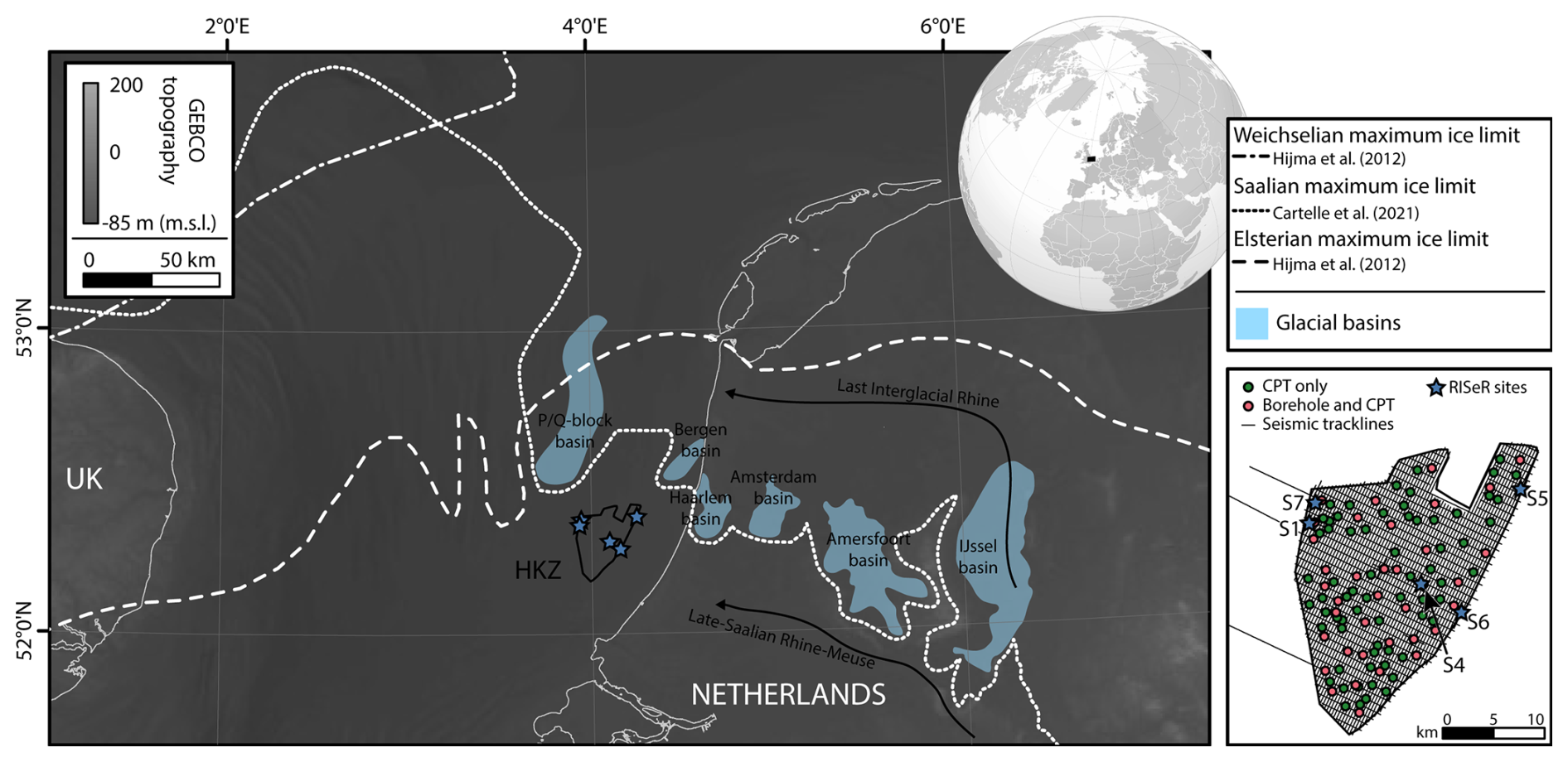
Figure 1Map showing the location of the HKZ wind farm in the southern North Sea, alongside the offshore maximum ice sheet extension for the Weichselian (Marine Isotope Stage (MIS) 2), late Saalian (MIS 6; Drenthe substage), and Elsterian (MIS 12 and/or 10). Glaciations are displayed with onshore and offshore features after Cartelle et al. (2021). Modern bathymetry and topography are from GEBCO (https://www.gebco.net, last access: 1 May 2024). The inset map shows seismic track lines (multi-channel sparker data) within the HKZ wind farm and the location of boreholes and cone penetration test (CPT) sites.
The southern North Sea basin lies at, or beyond, the limit of the major advances of the Eurasian Ice Sheet during the last 500 000 years (Fig. 1). Three main episodes of glacial advance, regionally termed in northwestern Europe as the Elsterian (≈ marine isotope stage (MIS) 12), Saalian (≈ MIS 6), and Weichselian (≈ MIS 2), are widely recognized in the stratigraphy of the region (e.g. Ehlers and Gibbard, 2004; Busschers et al., 2008; Lauer and Weiss, 2018; Gandy et al., 2021, Fig. 1). Overprinting evidence of these three major glacial advances are deposits associated with smaller Middle and Late Pleistocene North Sea glaciations, which have been identified through improved geophysical and sedimentary data, particularly in the central North Sea (Beets et al., 2005; Graham et al., 2011; Phillips et al., 2017; Ottesen et al., 2018). During sea-level lowstands associated with periods of cool climate and expanded terrestrial ice masses, the exposed terrestrial landscape south of the ice margins provided an important corridor for human migration (Preece, 1995; Hijma et al., 2012; Cohen et al., 2012; Gaffney et al., 2024). During periods of ice sheet retreat, resultant relative sea-level rise transformed the southern North Sea into a proximal coastal environment and, subsequently, a shallow marine environment (e.g. Hijma et al., 2012; Eaton et al., 2020; Cameron et al., 1992; Zagwijn, 1973). In addition to recording complex patterns of ice advance and retreat and associated changes in relative sea level, the shallow subsurface of the southern North Sea basin also records a history of dynamic fluvial networks during the Late Quaternary. In particular, the evolution of the major river systems in NW Europe, such as the Rhine–Meuse and the Thames, deposited a patchwork of fluvial and estuarine sediments in the basin (Peeters et al., 2015; Gibbard and Cohen, 2015).
The Quaternary stratigraphy of the southern North Sea therefore records a complex interplay of Earth system responses, capturing glacial isostatic loading and unloading, barystatic sea-level rise due to the melting of far-field ice sheets (e.g. Laurentide, Antarctica), and a variable sediment supply (glacial, fluvial, and marine) and load (e.g. Long et al., 2015; Bradley et al., 2023; Busschers et al., 2007, 2008; Peeters et al., 2016). However, much of our understanding of Quaternary landscape change in the southern North Sea prior to the Holocene is based upon spatially restrictive snapshots from limited boreholes and/or discrete geophysical datasets. The highly heterogeneous Quaternary sediments that fill the southern North Sea basin provide the foundations for a rapidly growing offshore wind industry. Therefore, understanding the evolution of the subsurface is not only an academic exercise, but also provides critical input into the development of ground models and the assessment of geohazards for offshore wind (Velenturf et al., 2021). New high-resolution and high-density subsurface geophysical datasets from offshore wind farm site investigations have led to a step change in the resolution of stratigraphic mapping, advancing our understanding of the genesis, preservation, and former landscape settings of the submerged Quaternary (e.g. Cotterill et al., 2017; Emery et al., 2019b, a; Eaton et al., 2020; Mellett et al., 2020; Cartelle et al., 2021; Waajen et al., 2024).
Piecing together these new localized reconstructions of submerged palaeolandscapes requires robust correlation, a major challenge in regions with dynamic sedimentary regimes. Basin-scale correlations are hindered by a lack of chronostratigraphic constraints, particularly in sediments which cannot be dated, as they sit beyond the limit of radiocarbon dating and calibration (> 50 ka; Reimer et al., 2020). To date, the primary chronological framework for the Quaternary southern North Sea is based on the pollen zonation schemes of the Netherlands (e.g. Zagwijn, 1961, 1973) and Britain (e.g. West, 1957; Turner and West, 1968). Correlation of the pollen record across the patchwork of fluvial and marine sediments that comprise the majority of the North Sea basin is hindered by variable pollen concentrations and reworking of Middle and Early Pleistocene taxa (Scourse et al., 1998; McGuire et al., 2024). Palaeomagnetic studies have also been used to date sequences, although such approaches are challenging in discontinuous records where the depositional regimes vary (e.g. Scheidt et al., 2015). There is a critical need to overcome these chronological challenges (McGuire et al., 2024), both to better understand regional and local sedimentary evolution in response to climate change and to test existing stratigraphic correlations across the basin, which in turn will help constrain rates of landscape response to climate and environmental forcings.
Here, we present five new cores from the Dutch sector of the southern North Sea, collected as part of the European Research Council-funded Rates of Interglacial Sea-level Change and Responses (RISeR) project, which provides an exciting opportunity for in-depth stratigraphic description of the shallow sediments (< 40 m) in the Hollandse Kust Zuid (HKZ) wind farm zone. We introduce the stratigraphy of the cores and place them in the context of seismic stratigraphic data acquired to support wind farm development in the region before outlining next steps to be undertaken in order to date the cores and situate them within a broader context of palaeoenvironmental change.
The HKZ offshore wind farm is located in the southern North Sea, ca. 18–36 km west of the Dutch coast (Fig. 1). The wind farm site has a maximum water depth of ca. 28 m and an area of ca. 225 km2. The area was targeted for core collection due to (1) its position south of Middle and Late Pleistocene ice sheet limits (Cartelle et al., 2021; Fig. 1), minimizing potential glacial erosion; (2) earlier work that suggested preservation of Middle and Late Pleistocene sediments in the area (Zagwijn, 1983; van Heteren, 2010); and (3) the wealth of high-resolution seismic reflection data recently collected as part of wind farm site surveys (Fugro, 2016). We developed an integrated dataset of geophysical and sedimentary data, including legacy seismic data (mainly regional seismic lines), boreholes recorded in the DINOloket database (https://www.dinoloket.nl/en, last access: 24 October 2025), and comprehensive surveys conducted by Fugro between 2016 and 2017 on behalf of the Netherlands Enterprise Agency (RVO) for detailed assessment of the location of potential coring locations. The newly collected wind farm survey data offered unprecedented insight into the sediments preserved in HKZ due to the much greater density and resolution relative to the legacy seismic data. The shallow subsurface of the HKZ wind farm was imaged using a subbottom profiler (SBP), a single-channel sparker (SCS), and a high-resolution multi-channel sparker (MCS), but mapping was mainly conducted using the SCS data. The SCS data were collected using a GSO 100-tip sparker operating at 200–300 J, with a frequency peak value of 825 Hz for the study site. Processing included band pass filtering (350–400 to 1200–1300 Hz), FK filtering, swell filtering, and time-to-depth conversion using a sound velocity of 1600 m s−1. Further detail on seismic imaging can be found in Cartelle et al. (2021). The geotechnical investigations in HKZ (Fugro, 2016) also provide sedimentological data from 35 new boreholes, a limited number of which were targeted for low-resolution pollen analysis (StrataData, 2017).
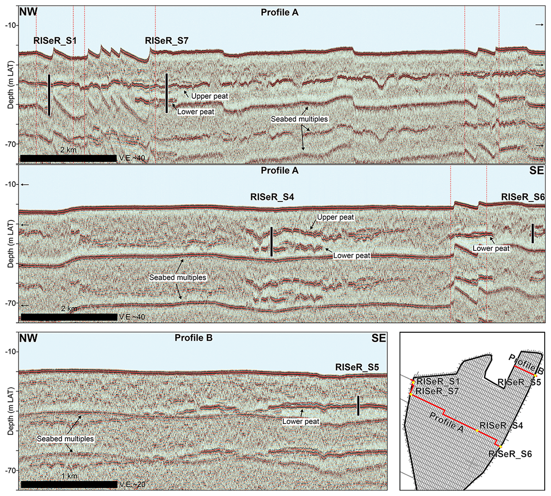
Figure 2Seismic profiles (single-channel sparker) throughout the study site. Profile A (upper two panels) is a composite of multiple seismic reflections from NW to SE across the locations of RISeR_S1, RISeR_S7, RISeR_S4, and RISeR_S6. High-amplitude reflectors correspond to peat deposits. The upper peat is continuous across most of the wind farm site. The lower peat appears scattered but is attributed to the same stratigraphic level. The dotted red lines indicate changes in the direction of the seismic profile. Profile B (lower panel) shows the location of RISeR_S5, which was drilled on the margin of a topographic depression displaying a continuous peat deposit at its base.
The selection of the five core sites was based on the identification of terrestrial peat surfaces in both the borehole and seismic reflection datasets (Fig. 2). These peat surfaces have a strong geophysical response and mark the presence of palaeo-land surfaces, which in turn increases the likelihood of collecting sediments from one or more glacial–interglacial cycles, providing evidence of subsequent marine transgression to understand landscape response to relative sea-level change. Our site selection aimed to maximize the vertical range in the elevation of the peat deposits and therefore the temporal range and vertical elevation of any marine transgression recorded in the cores. Sites were also selected to maximize the likelihood of recovering deposits from earlier Quaternary interglacials below the Holocene sediments. In particular, StrataData (2017) report radiocarbon dates and warm pollen assemblages (including Quercus, Corylus, and Carpinus) within the HKZ peat deposits, which they link to the Eemian pollen zones established by Zagwijn (1961). Broadly, two peat levels are identified in the HKZ seismic reflection data in the top 50 m: an upper high-amplitude reflection surface, continuous across most of the wind farm site, and a discontinuous lower peat surface tentatively attributed to a single stratigraphic level (Fig. 2).
Scientific drilling in heavily industrialized shallow seas requires careful negotiation to ensure research aims can be met whilst respecting the myriad competing interests which govern the seabed. In selecting the core sites, it was essential to consider the highly-concentrated infrastructure (e.g. cables, pipelines, offshore platforms), commercial activities (e.g. maintenance of infrastructure, sand extraction, navigation), and contacts (e.g. shipwrecks, acoustic or magnetic anomalies) within HKZ (Fig. 3). Detailed mapping of the site was therefore necessary to avoid obstacles or areas where drilling activities are not permitted and to minimize the risks associated with unexploded ordnance (many of which originated during the two 20th-century World Wars) on the seabed. To achieve this, our seismic mapping was supplemented by the data provided by the Netherlands Enterprise Agency (RVO; https://offshorewind.rvo.nl, last access: 24 September 2025), including the location of seabed cables and pipes, crashed aircraft, shipwrecks, and unclassified obstacles. The timing of the RISeR drilling was also constrained by industrial development. During 2020, final site investigations were conducted in HKZ, leaving a small window for drilling prior to wind turbine construction starting in July 2021. The wind farm was inaugurated in September 2023 and contains 139 turbines with the potential to produce 1.5 GW, sufficient to power 1.5 million households in the Netherlands. Since December 2023, it has been fully operational.
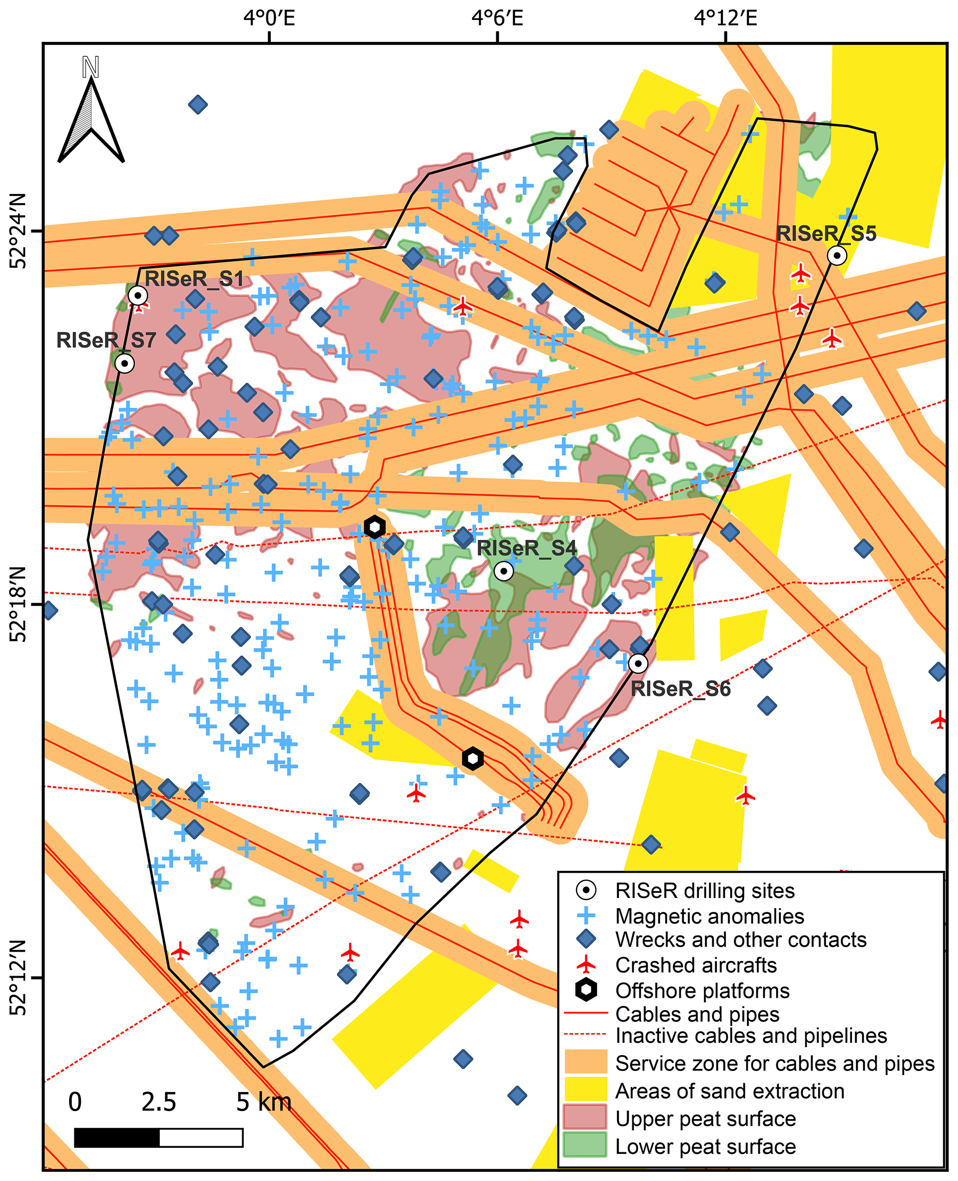
Figure 3Map displaying infrastructure (cables, pipelines, and platforms), sand extraction areas, shipwrecks and unknown contacts, crashed aircraft, and magnetic anomalies in the area of the HKZ wind farm (as provided by RVO, https://offshorewind.rvo.nl) that had to be considered for the selection of the drilling sites.
Five cores (Fig. 3; Table 1) were collected from the HKZ wind farm over 2 d (14 and 15 July 2020) using the geotechnical drilling vessel MV Normand Flower, navigated and positioned by Fugro. Due to the COVID-19 pandemic and operational restrictions, no scientists were on board, but regular remote communication was carried out. Surface positioning was undertaken using two StarPack global navigation satellite system (GNSS) receivers, with underwater positioning utilizing the Kongsberg Simrad HiPAP 500 ultra-short baseline (USBL) positioning system. All depth measurements were reduced to the lowest astronomical tide (LAT), using real-time GNSS tides. Multiple techniques were used to measure water depth at each sample location: echosounder, USBL depth, conductivity, temperature, depth probe, and drill string (Table 1). Positioning and peripheral navigational data (e.g. gyrocompass, USBL) were sent to the navigation computer, which calculated offset positions in the local geodesy and with respect to the European Terrestrial Reference System 1989 (ETRS89 UTM 31N). Open-hole drilling was performed to remove well-documented Holocene sands, with semi-continuous liner sampling from 10 m below the seabed (BSF) for RISeR_S1, RISeR_S4, RISeR_S5, and RISeR_S6 and from 12 m below the seabed for RISeR_S7. Shallow subsurface sediments from the seabed to the core top (10–12 m) were not logged or collected due to resource limitations. Drilling used thin-walled Shelby tubes with a diameter of 7.62 cm (3 in.) with top–bottom orientation marked on the liner and, where possible, material collected in the core-cutting shoe placed in sample bags without orientation.
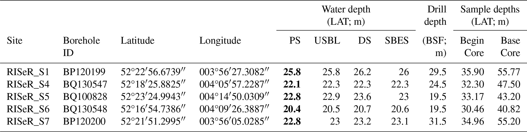
Table 1Location, water depth, and drilling depths at the RISeR drill sites, with drill core and sample recovery for each site. Water depths were derived by Fugro through multiple methods, including a portable depth sounder (PS), ultra-short baseline (USBL), drill string (DS), and single-beam echosounders (SBES). Note that upper metres directly below the seabed were not cored (see inset Fig. 4). Values in bold were used to determine the depth of the sites below LAT.
Following retrieval in 2020, the cores were transported to, and temporarily stored at, the British Ocean Sediment Core Research Facility (BOSCORF) at the National Oceanography Centre (Southampton, UK), where they were split and scanned non-destructively. At BOSCORF, the cores were split using the Geotek core splitter and subsequently imaged using Geotek MSCL-CIS (Core Imaging System) and the Geotek ScoutXcan X-Ray Imaging Scanner, which produced high-resolution 2D radiographic images and pseudo-3D laminographic images (McGuire et al., 2025). Results presented here focus on the detailed core logging undertaken at the University of Leeds, UK, which includes core lithology and colour (using a Munsell colour chart), and the identification of decalcified horizons (negatively testing for carbonate presence with 5 % dilute HCl) and pedogenetically carbonate-enriched levels bearing f CaCO3 nodules several millimetres in diameter. Since 2021, cores and subsamples have been in cold storage (3–5 °C) in the School of Earth and Environment at the University of Leeds, UK.
The five RISeR cores comprise a varied suite of sedimentary facies (Fig. 4), ranging from in situ peat deposits to well-sorted coarse-grained sands. Each core contains an upper and a lower peat unit, interspersed by semi-consolidated clays, silts, sands, and gravels (Fig. 4). Here, we broadly describe the key sedimentary facies within the cores, which we then integrate with the seismic reflection data in Sect. 6.
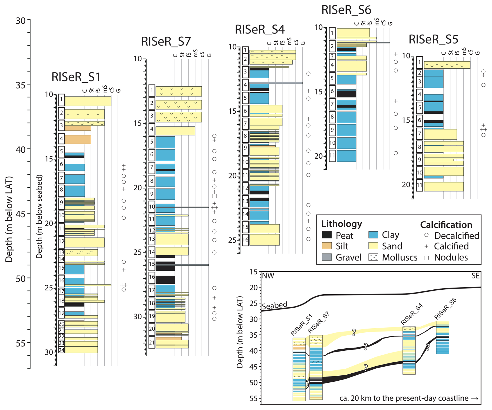
Figure 4Stratigraphic logs of the RISeR cores, with the inset diagram showing potential correlations between the facies based on visual logging of the cores and seismic data (excluding RISeR_S5, which does not lie along the same NW–SE transect).
The base of all cores (except RISeR_S6) primarily comprises sands, typically fine sands with medium-grained sands at the base of RISeR_S5. Overlying these sands and at the base of RISeR_S6, the sediments consist of silty clays with a gradual transition into organic-rich peat deposits. The sedimentology of these minerogenic units differs between the sites. For example, in RISeR_S1, sediments are unstructured up to ca. 53 m below LAT, where evidence of rooting is observed in the laminography, accompanied by a gradual transition to finer clays and silts with increased organic content up to the base of the lower peat unit. Given their sedimentary facies, including the presence of rooting features, decalcified top underlain by levels with calcareous nodules, steel-blueish hues, and a lack of sedimentary structure, these clay and silt intervals are interpreted as a first palaeosol.
In all five cores, the lowermost peat unit is primarily an in situ woody peat; however, the depth of the peat with respect to the seabed varies considerably. In RISeR_S1, the lower peat is < 0.3 m thick, 1 order of magnitude thinner than the ca. 3 m thick peat deposit in RISeR_S7. In RISeR_S7, an abrupt contact between the lower peat and the overlying fine sands suggests an erosional surface. A similarly abrupt contact marks the boundary between the lower peat and the overlying clay in RISeR_S1. There is no indication of erosion of the peat surface in RISeR_S4, RISeR_S6, and RISeR_S5, where the lower peat gradually transitions to overlying clays.
In RISeR_S1, RISeR_S7, and RISeR_S5, above the lower peat, the lithology comprises alternating sand and clay facies, terminating in an upper peat unit at ca. 40.5, 41.5, and 37 m below LAT, respectively (Fig. 4). Paleosol overprints are also present in the clay facies here. In RISeR_S6, there is an additional, third, organic unit. Sediments from 34.7 to 34.2 m below LAT comprise dark-grey clays with high organic content, featuring numerous lenses of organic material, most likely ex situ peat. The intermediate organic unit in RISeR_S6 is overlain by well-sorted very fine sands, consisting predominantly of quartz, which show distinct horizontal laminae up to ca. 32.6 m below LAT. In RISeR_S4, between the correlated lower and upper peats, there is an interval of interbedded, thin organic layers (typically < 0.05 m) with a high clay content in otherwise sandy sediments from 40 to 38 m below LAT. This is not interpreted as a terrestrial peat but rather a freshwater subaqueous channel-fill.
An upper peat layer is present in all cores, varying in depth and thickness. In RISeR_S1, the upper peat (base ca. 40.7 m below LAT) is 0.18 m thick and contains large woody fragments, often > 10 mm in diameter, and is overlain by a gradual transition to clays and interbedded clay-rich organics. In RISeR_S7, the upper peat is < 0.1 m thick with no visible macrofossils suggesting increased humification. In RISeR_S4, the upper peat (base ca. 35.5 m below LAT) is a ca. 0.2 m thick deposit, containing large (> 20 mm) wood fragments towards the top, transitioning into clays with large organic fragments. This is overlain by a gravel unit with occasional clasts > 30 mm in diameter supported by an organic-rich matrix. The upper peat in RISeR_S6 is ca. 0.12 m thick, and has an abrupt contact with the underlying clays at ca. 32.2 m below LAT. Overlying the RISeR_S6 upper peat unit, there is a gradational (ca. 0.1 m) transition into clays before an abrupt transition (erosional contact) into coarse sands interbedded with clay-rich organics. The upper peat in RISeR_S5 is a 0.22 m thick, well-humified deposit. The surface of the RISER_S5 peat is marked by a gradual transition into a minerogenic unit, laminated throughout with fine sands, clays, and silts.
In all cores, there is an upper minerogenic, dominantly sandy facies with an erosional basal contact. In RISeR_S1, RISeR_S4, RISeR_S5, and RISeR_S7, this upper facies consists primarily of coarse sands, with shell fragments throughout. In RISeR_S6, medium and fine sands dominate, which do not contain shell fragments.
The high-resolution seismic reflection data collected in HKZ for the offshore wind industry motivated the selection of the core locations (targeting locations with two peat-attributable reflections) but in turn also provide an opportunity to understand the lateral continuity and extent of encountered units and stratigraphic correlation (or lack thereof) between levels in the RISeR cores. Here, we present our initial results based on integrating the HKZ geophysical datasets with the RISeR cores.
Some of the sedimentary units present in the RISeR cores can be traced laterally in the seismic reflection data. For example, the surface of the upper peat can be mapped between RISeR_S1 and RISeR_S7 and between RISeR_S4 and RISeR_S6, although these sites are separated by a small channel form infill (Fig. 2). There is a large channel form incision between the east (where RISeR_S5 and RISeR_S6 are located) and the west (location of RISeR_S1 and RISeR_S7) of the HKZ wind farm, so, whilst it is likely that the two peats represent the same surface, it is not possible to confirm this by tracing the contact in seismic reflection data (i.e. other types of investigation are needed to test and develop core-to-core stratigraphic correlations). Each RISeR core contains an in situ lower peat unit; however, this peat unit is laterally discontinuous between each of the core sites in the seismic reflection data (Fig. 2). Due to the patchy distribution of the lower peat unit, we are reliant on facies association with the over-/underlying units, which, when integrated with the HKZ wind farm borehole logs (Fig. 1), can support the core-to-core correlation of the RISeR sites (Fig. 4). We note that these correlations should be tested and tuned with future laboratory analysis developing biostratigraphical and geochronological results.
Peat deposits provide useful horizons in seismic reflection data due to their unique seismic properties (e.g Eaton et al., 2024), which our results show are closely correlated with the units present in the cores (Figs. 2, 4). However, the vertical resolution of seismic reflection data, the complexities of resolving seismic facies that have quite similar reflectance properties (e.g. silts and clays), and the presence of sound-attenuating peat deposits mean that detailed comparison between the seismic and core stratigraphy should be undertaken with caution. For example, the multichannel sparker used in HKZ is limited to a vertical resolution of 50–100 cm, so any changes thinner than that will not be imaged, and thin layers driving marked changes in the acoustic properties may completely mask the dominant lithology. In general, the sedimentary intervals dominated by clay and silt deposits or interbedded clays and sands in the RISeR cores correspond to seismic facies characterized by continuous reflections of low amplitude and medium frequency and by a lateral continuity on the order of hundreds of metres to a few kilometres. Sediments at the base and top of the cores comprise fine to medium sands and generally feature as discontinuous reflections of higher amplitude. Seismic facies at depths that coincide with the base of the cores are highly disturbed by the acoustic attenuation caused by the peat deposits and the presence of the seabed multiple, hindering detailed analyses and evaluation of their lateral continuity. The sands at the top of the cores are always associated with channel-fills with erosive bases that are present throughout the entire wind farm site.
Overall, the RISeR cores confirm initial interpretations of the geophysical and geotechnical data, revealing variable depositional environments including buried land surfaces in the Quaternary southern North Sea. Whilst the in situ peat layers are unambiguously terrestrial, as are the paleosol levels developed in the clays immediately below, the sands and clays have a range of potential origins. For example, they may be fluvial deposits from the Rhine–Meuse (including floodplains and channel-fills) or record intertidal to shallow marine conditions (including those occurring in lower delta plains and lagoons), of which all environments have been present during the complex Quaternary history of the southern North Sea (Cohen et al., 2014, 2017). From the general lack of shells, open marine depositional environments do not appear to have been recorded in the interval the coring focused on. We note that the overlying sandy shell-bearing unit can be traditionally explained by alternating reworking open marine conditions (waves at high stand) and reworking fluvial conditions (channels at low stand) as envisaged for the last glacial cycles (e.g. Busschers et al., 2007; Hijma et al., 2012; Waajen et al., 2024). In contrast, the accommodation of alternating relatively thin sandy units and relatively thick silty clayey units with palaeosols and intercalated peats requires a different depositional model. That model likely includes fluvio-deltaic depositional cycles (coastal prisms in sequence stratigraphic terms), slow subsidence rates, and considerable passing of time to explain the stacking of terrestrial overprinted units without recording intercalated marine levels, yet preserving this succession 40–50 m depth below the present and last interglacial sea levels.
The presence of widespread in situ peat deposits, laterally traceable in seismic reflection data, allows the mapping of now-submerged terrestrial landscapes preserved in the shallow subsurface of the southern North Sea. As the preservation of glacial landforms in the region can provide insights into ice sheet dynamics during periods of ice sheet retreat (e.g. Cartelle et al., 2021), the geomorphological properties of drowned terrestrial landscapes can provide new insights into the environmental response of the North Sea to climatic and relative sea-level change (e.g. Emery et al., 2019a, 2020).
Our identification of peat deposits interbedded with palaeosol units is, to our knowledge, the first in this area of the southern North Sea and suggests sustained terrestrial deposition. The identification of terrestrial deposits suggests that the records postdate the Early Pleistocene filling of the southern North Sea basin (Hijma et al., 2012). We identify no clear evidence of marine inundation within the sedimentary stratigraphy. Therefore, we tentatively assign the RISeR core stratigraphy to a temporal window between 1.5 and 0.5 Ma, subsequent to the infilling of the southern North Sea basin but prior to marine inundation of the basin during the sea-level highstands of the Middle and Late Quaternary interglacials (Kuhlmann and Wong, 2008; Ottesen et al., 2014, 2018).
Our findings are a marked contrast to the Late Pleistocene (Eemian; ca. 129 000–116 000 ka BP) age assigned in initial offshore wind farm reports (StrataData, 2017), and ongoing work on the RISeR cores is underway to establish less tentative chronologies for the five cores. The work includes more detailed palynological analysis that will allow us to integrate our new cores within the Quaternary pollen chronostratigraphic framework of the Netherlands (Zagwijn, 1961, 1985). It is extended by experimental luminescence dating and palaeomagnetic investigation. Luminescence dating techniques have been used to great effect in onshore Middle and Late Pleistocene archives in the Netherlands (e.g. Busschers et al., 2007; Peeters et al., 2016), where suitable sediments are present. Palaeomagnetic correlation also forms the backbone of much of the existing North Sea chronostratigraphic framework, and detailed analyses have the potential to place the deposits before or after the Brunhes–Matuyama boundary at 0.774 Ma and thus the Early and Middle Pleistocene. Ultimately, these parallel investigations on the RISeR cores should cross-validate the age attribution and detailed correlations of levels between the RISeR cores (Fig. 4).
New chronologies will facilitate comparison with archives in the wider North Sea basin (see Thompson et al., 1992, and references therein) and development of a revised Quaternary chronostratigraphic framework for the southern North Sea. These advances can be utilized to transform the high-resolution seismic reflection data gathered in the North Sea so widely in the last decade (by the offshore wind industry) into 21st-century geological subsurface models for the North Sea floor. Using this framework will allow us to develop landscape-scale reconstructions of palaeoenvironmental change for interglacials of choice. Ultimately, we seek to both increase our understanding of Quaternary landscape and climatic change and, in doing so, support future offshore renewable energy development and internationally coordinated management of the seabed.
The lithological (lithogenetical) and basic lithostratigraphical interpretations of the RISeR cores as documented in this paper have been shared with TNO Geological Survey of the Netherlands (TNO-GSN) and in converted form will be made available as part of their public geological data portal (http://dinoloket.nl/en, last access: 24 October 2025) using the TNO-GSN IDs included in Table 1. Geophysical, geotechnical, and geological data associated with recent wind farm surveys are available online at https://offshorewind.rvo.nl. Core images and laminography are archived on the Zenodo repository and can be accessed at https://doi.org/10.5281/zenodo.15584040 (McGuire et al., 2025). As part of further work, more detailed chronostratigraphic interpretations are to follow in future publications (in preparation at time of completion of this paper).
AMM: methodology, investigation, writing (original draft and review and editing). VC: methodology, investigation, data curation, writing (original draft and review and editing). GR: investigation, writing (review and editing). FSB: methodology, writing (review and editing). KMC: methodology, writing (review and editing). DMH: writing (review and editing). NLMB: conceptualization, methodology, writing (original draft and review and editing), funding acquisition.
The contact author has declared that none of the authors has any competing interests.
Publisher's note: Copernicus Publications remains neutral with regard to jurisdictional claims made in the text, published maps, institutional affiliations, or any other geographical representation in this paper. While Copernicus Publications makes every effort to include appropriate place names, the final responsibility lies with the authors. Views expressed in the text are those of the authors and do not necessarily reflect the views of the publisher.
We thank Robert Powell, Davide Gamterini, and Sven Plasman of Fugro, along with the crew of the MV Normand Flower, for their support throughout the scientific drilling programme. We also thank the Netherlands Enterprise Agency (RVO), in particular Ruud de Bruijne, and Vattenfall for providing access to the HKZ site and for providing the seismic reflection data used in this study free of charge, licensed under Creative Commons 4.0 CC-BY-SA. We are grateful to Claire Mellett and Carol Cotterill for their advice when choosing core sites and sharing their expertise on the North Sea subsurface and to the excellent staff at BOSCORF for facilitating core transport, storage, and splitting. We thank Katrien Van Landeghem and one anonymous referee for their careful reading and comments on the originally submitted article.
This research has been supported by the European Research Council, H2020 European Research Council (grant no. 802281).
This paper was edited by Nadine Hallmann and reviewed by Katrien Van Landeghem and one anonymous referee.
Beets, D. J., Meijer, T., Beets, C. J., Cleveringa, P., Laban, C., and van der Spek, A. J.: Evidence for a Middle Pleistocene Glaciation of MIS 8 Age in the Southern North Sea, Quaternary International, 133–134, 7–19, https://doi.org/10.1016/j.quaint.2004.10.002, 2005. a
Bradley, S. L., Ely, J. C., Clark, C. D., Edwards, R. J., and Shennan, I.: Reconstruction of the Palaeo-Sea Level of Britain and Ireland Arising from Empirical Constraints of Ice Extent: Implications for Regional Sea Level Forecasts and North American Ice Sheet Volume, Journal of Quaternary Science, 38, 791–805, https://doi.org/10.1002/jqs.3523, 2023. a
Busschers, F., Kasse, C., Van Balen, R., Vandenberghe, J., Cohen, K., Weerts, H., Wallinga, J., Johns, C., Cleveringa, P., and Bunnik, F.: Late Pleistocene Evolution of the Rhine-Meuse System in the Southern North Sea Basin: Imprints of Climate Change, Sea-Level Oscillation and Glacio-Isostacy, Quaternary Science Reviews, 26, 3216–3248, https://doi.org/10.1016/j.quascirev.2007.07.013, 2007. a, b, c
Busschers, F. S., Van Balen, R. T., Cohen, K. M., Kasse, C., Weerts, H. J. T., Wallinga, J., and Bunnik, F. P. M.: Response of the Rhine–Meuse Fluvial System to Saalian Ice-sheet Dynamics, Boreas, 37, 377–398, https://doi.org/10.1111/j.1502-3885.2008.00025.x, 2008. a, b
Busschers, F. S., Cohen, K. M., Wesselingh, F., Schokker, J., Bakker, M. A. J., Van Balen, R., and Van Heteren, S.: Quaternary, in: Geology of the Netherlands, edited by: ten Veen, J., Vis, G.-J., and de Jager, Janand Wong, T., Amsterdam University Press, ISBN 978-94-6372-836-2, 2025. a, b
Cameron, T. D. J., Crosby, A., Balson, P. S., Jeffery, D. H., Lott, G. K., Bulat, J., and Harrison, D. J.: United Kingdom Offshore Regional Report: The Geology of the Southern North Sea, HMSO for the British Geological Survey, London, ISBN 0-11-884492-X, 1992. a
Cartelle, V., Barlow, N. L. M., Hodgson, D. M., Busschers, F. S., Cohen, K. M., Meijninger, B. M. L., and van Kesteren, W. P.: Sedimentary architecture and landforms of the late Saalian (MIS 6) ice sheet margin offshore of the Netherlands, Earth Surf. Dynam., 9, 1399–1421, https://doi.org/10.5194/esurf-9-1399-2021, 2021. a, b, c, d, e
Cohen, K., Gibbard, P., and Weerts, H.: North Sea Palaeogeographical Reconstructions for the Last 1 Ma, Netherlands Journal of Geosciences – Geologie en Mijnbouw, 93, 7–29, https://doi.org/10.1017/njg.2014.12, 2014. a
Cohen, K. M., MacDonald, K., Joordens, J. C., Roebroeks, W., and Gibbard, P. L.: The Earliest Occupation of North-West Europe: A Coastal Perspective, Quaternary International, 271, 70–83, https://doi.org/10.1016/j.quaint.2011.11.003, 2012. a
Cohen, K. M., Westley, K., Erkens, G., Hijma, M. P., and Weerts, H. J.: The North Sea, in: Submerged Landscapes of the European Continental Shelf, edited by: Flemming, N. C., Harff, J., Moura, D., Burgess, A., and Bailey, G. N., Wiley, 1st edn., 147–186, ISBN 978-1-118-92213-2, https://doi.org/10.1002/9781118927823.ch7, 2017. a
Cotterill, C. J., Phillips, E., James, L., Forsberg, C. F., Tjelta, T. I., Carter, G., and Dove, D.: The Evolution of the Dogger Bank, North Sea: A Complex History of Terrestrial, Glacial and Marine Environmental Change, Quaternary Science Reviews, 171, 136–153, https://doi.org/10.1016/j.quascirev.2017.07.006, 2017. a
Eaton, S., Barlow, N. L. M., Hodgson, D. M., Mellett, C. L., and Emery, A. R.: Landscape Evolution during Holocene Transgression of a Mid-Latitude Low-Relief Coastal Plain: The Southern North Sea, Earth Surface Processes and Landforms, 49, 3139–3157, https://doi.org/10.1002/esp.5880, 2024. a
Eaton, S. J., Hodgson, D. M., Barlow, N. L. M., Mortimer, E. E. J., and Mellett, C. L.: Palaeogeographical Changes in Response to Glacial–Interglacial Cycles, as Recorded in Middle and Late Pleistocene Seismic Stratigraphy, Southern North Sea, Journal of Quaternary Science, 35, 760–775, https://doi.org/10.1002/jqs.3230, 2020. a, b
Ehlers, J. and Gibbard, P. L. (Eds.): Quaternary Glaciations: Extent and Chronology, no. 2 in Developments in Quaternary Science, Elsevier, Amsterdam, San Diego, 1st edn., ISBN 978-0-444-51462-2, 2004. a
Emery, A. R., Hodgson, D. M., Barlow, N. L., Carrivick, J. L., Cotterill, C. J., Mellett, C. L., and Booth, A. D.: Topographic and Hydrodynamic Controls on Barrier Retreat and Preservation: An Example from Dogger Bank, North Sea, Marine Geology, 416, 105981, https://doi.org/10.1016/j.margeo.2019.105981, 2019a. a, b
Emery, A. R., Hodgson, D. M., Barlow, N. L., Carrivick, J. L., Cotterill, C. J., and Phillips, E.: Left High and Dry: Deglaciation of Dogger Bank, North Sea, Recorded in Proglacial Lake Evolution, Frontiers in Earth Science, 7, 1–27, https://doi.org/10.3389/feart.2019.00234, 2019b. a
Emery, A. R., Hodgson, D. M., Barlow, N. L. M., Carrivick, J. L., Cotterill, C. J., Richardson, J. C., Ivanovic, R. F., and Mellett, C. L.: Ice sheet and palaeoclimate controls on drainage network evolution: an example from Dogger Bank, North Sea, Earth Surf. Dynam., 8, 869–891, https://doi.org/10.5194/esurf-8-869-2020, 2020. a
Fugro: Geophysical Survey HKZ I to IV, Netherlands Enterprise Agency [data set], https://offshorewind.rvo.nl/soilzh (last access: 24 October 2021), 2016. a, b
Gaffney, V., Harding, R., Fitch, S., Walker, J., Boothby, V., and Fraser, A. I.: Winds of Change: Urgent Challenges and Emerging Opportunities in Submerged Prehistory, a Perspective from the North Sea, Heritage, 7, 1947–1968, https://doi.org/10.3390/heritage7040093, 2024. a
Gandy, N., Gregoire, L. J., Ely, J. C., Cornford, S. L., Clark, C. D., and Hodgson, D. M.: Collapse of the Last Eurasian Ice Sheet in the North Sea Modulated by Combined Processes of Ice Flow, Surface Melt, and Marine Ice Sheet Instabilities, Journal of Geophysical Research: Earth Surface, 126, e2020JF005755, https://doi.org/10.1029/2020JF005755, 2021. a
Gibbard, P. L. and Cohen, K. M.: Quaternary evolution of the North Sea and the English Channel, Proceedings of the Open University Geological Society, 1, 63–74, 2015. a
Graham, A. G., Stoker, M. S., Lonergan, L., Bradwell, T., and Stewart, M. A.: The Pleistocene Glaciations of the North Sea Basin, Developments in Quaternary Sciences, 15, 261–278, https://doi.org/10.1016/B978-0-444-53447-7.00021-0, 2011. a
Hijma, M. P., Cohen, K. M., Roebroeks, W., Westerhoff, W. E., and Busschers, F. S.: Pleistocene Rhine–Thames Landscapes: Geological Background for Hominin Occupation of the Southern North Sea Region, Journal of Quaternary Science, 27, 17–39, https://doi.org/10.1002/jqs.1549, 2012. a, b, c, d
King, E., Haflidason, H., Sejrup, H., and Løvlie, R.: Glacigenic Debris Flows on the North Sea Trough Mouth Fan during Ice Stream Maxima, Marine Geology, 152, 217–246, https://doi.org/10.1016/S0025-3227(98)00072-3, 1998. a
Kuhlmann, G. and Wong, T. E.: Pliocene Paleoenvironment Evolution as Interpreted from 3D-seismic Data in the Southern North Sea, Dutch Offshore Sector, Marine and Petroleum Geology, 25, 173–189, https://doi.org/10.1016/j.marpetgeo.2007.05.009, 2008. a, b, c
Lamb, R. M., Harding, R., Huuse, M., Stewart, M., and Brocklehurst, S. H.: The Early Quaternary North Sea Basin, Journal of the Geological Society, 175, 275–290, https://doi.org/10.1144/jgs2017-057, 2018. a, b, c
Lauer, T. and Weiss, M.: Timing of the Saalian- and Elsterian glacial cycles and the implications for Middle – Pleistocene hominin presence in central Europe, Scientific Reports, 8, 5111, https://doi.org/10.1038/s41598-018-23541-w, 2018. a
Long, A. J., Barlow, N. L. M., Busschers, F. S., Cohen, K. M., Gehrels, W. R., and Wake, L. M.: Near-Field Sea-Level Variability in Northwest Europe and Ice Sheet Stability during the Last Interglacial, Quaternary Science Reviews, 126, 26–40, https://doi.org/10.1016/j.quascirev.2015.08.021, 2015. a
McGuire, A., Cartelle, V., Rush, G., Busschers, F., Cohen, K., Hodgson, D., and Barlow, N.: The RISeR cores: core imaging and laminography, Zenodo [data set], https://doi.org/10.5281/zenodo.15584040, 2025. a, b
McGuire, A. M., Waajen, I. M., and Barlow, N. L.: Advancing Chronologies for Last Interglacial Sequences, Journal of Quaternary Science, https://doi.org/10.1002/jqs.3641, 2024. a, b
Mellett, C. L., Phillips, E., Lee, J. R., Cotterill, C. J., Tjelta, T. I., James, L., and Duffy, C.: Elsterian Ice-Sheet Retreat in the Southern North Sea: Antecedent Controls on Large-Scale Glaciotectonics and Subglacial Bed Conditions, Boreas. Münstersche Beiträge zur Archäologie, 49, 129–151, https://doi.org/10.1111/bor.12410, 2020. a
Ottesen, D., Dowdeswell, J. A., and Bugge, T.: Morphology, Sedimentary Infill and Depositional Environments of the Early Quaternary North Sea Basin (56°–62° N), Marine and Petroleum Geology, 56, 123–146, https://doi.org/10.1016/j.marpetgeo.2014.04.007, 2014. a, b, c
Ottesen, D., Batchelor, C. L., Dowdeswell, J. A., and Løseth, H.: Morphology and Pattern of Quaternary Sedimentation in the North Sea Basin (52–62° N), Marine and Petroleum Geology, 98, 836–859, https://doi.org/10.1016/j.marpetgeo.2018.08.022, 2018. a, b, c, d, e
Peeters, J., Busschers, F. S., and Stouthamer, E.: Fluvial Evolution of the Rhine during the Last Interglacial-Glacial Cycle in the Southern North Sea Basin: A Review and Look Forward, Quaternary International, 357, 176–188, https://doi.org/10.1016/j.quaint.2014.03.024, 2015. a
Peeters, J., Busschers, F. S., Stouthamer, E., Bosch, J. H. A., Van den Berg, M. W., Wallinga, J., Versendaal, A. J., Bunnik, F. P. M., and Middelkoop, H.: Sedimentary Architecture and Chronostratigraphy of a Late Quaternary Incised-Valley Fill: A Case Study of the Late Middle and Late Pleistocene Rhine System in the Netherlands, Quaternary Science Reviews, 131, 211–236, https://doi.org/10.1016/j.quascirev.2015.10.015, 2016. a, b
Phillips, E., Hodgson, D. M., and Emery, A. R.: The Quaternary Geology of the North Sea Basin, Journal of Quaternary Science, 32, 117–126, https://doi.org/10.1002/jqs.2932, 2017. a
Preece, R. C.: Introduction – Island Britain: A Quaternary Perspective, Geological Society, London, Special Publications, 96, 1–2, https://doi.org/10.1144/GSL.SP.1995.096.01.01, 1995. a
Reimer, P. J., Austin, W. E. N., Bard, E., Bayliss, A., Blackwell, P. G., Bronk Ramsey, C., Butzin, M., Cheng, H., Edwards, R. L., Friedrich, M., Grootes, P. M., Guilderson, T. P., Hajdas, I., Heaton, T. J., Hogg, A. G., Hughen, K. A., Kromer, B., Manning, S. W., Muscheler, R., Palmer, J. G., Pearson, C., Van Der Plicht, J., Reimer, R. W., Richards, D. A., Scott, E. M., Southon, J. R., Turney, C. S. M., Wacker, L., Adolphi, F., Büntgen, U., Capano, M., Fahrni, S. M., Fogtmann-Schulz, A., Friedrich, R., Köhler, P., Kudsk, S., Miyake, F., Olsen, J., Reinig, F., Sakamoto, M., Sookdeo, A., and Talamo, S.: The IntCal20 Northern Hemisphere Radiocarbon Age Calibration Curve (0–55 Cal kBP), Radiocarbon, 62, 725–757, https://doi.org/10.1017/RDC.2020.41, 2020. a
Scheidt, S., Hambach, U., and Rolf, C.: A Consistent Magnetic Polarity Stratigraphy of Late Neogene to Quaternary Fluvial Sediments from the Heidelberg Basin (Germany): A New Time Frame for the Plio–Pleistocene Palaeoclimatic Evolution of the Rhine Basin, Global and Planetary Change, 127, 103–116, https://doi.org/10.1016/j.gloplacha.2015.01.004, 2015. a
Scourse, J., Ansari, M., Wingfield, R., Harland, R., and Balson, P.: A Middle Pleistocene Shallow Marine Interglacial Sequence, Inner Silver Pit, Southern North Sea, Quaternary Science Reviews, 17, 871–900, https://doi.org/10.1016/S0277-3791(98)00023-7, 1998. a
StrataData: Geochronology of Boreholes from Hollandse Kust (Zuid) Wind Farm Zone, Dutch Sector, North Sea, Report No: 08/17 (Final Version), Tech. rep., StrataData, Ottershaw, 2017. a, b, c
Thompson, R., Cameron, T. D. J., Schwarz, C., Jensen, K. A., Maenhaut Lemberge, V. V., and Sha, L. P.: The Magnetic Properties of Quaternary and Tertiary Sediments in the Southern North Sea, Journal of Quaternary Science, 7, 319–334, https://doi.org/10.1002/jqs.3390070407, 1992. a
Turner, C. and West, R. G.: The subdivision and zonation of interglacial periods, E&G Quaternary Sci. J., 19, 93–101, https://doi.org/10.3285/eg.19.1.06, 1968. a
van Heteren, S.: We@Sea project 2005-005. Analysis of seabed and soil quality required for wind farms., Tech. Rep. Final Report, TNO-Geological Survey of the Netherlands, 2010. a
Van Heteren, S., Meekes, J. A., Bakker, M. A., Gaffney, V., Fitch, S., Gearey, B. R., and Paap, B. F.: Reconstructing North Sea Palaeolandscapes from 3D and High-Density 2D Seismic Data: An Overview, Geologie en Mijnbouw/Netherlands Journal of Geosciences, 93, 31–42, https://doi.org/10.1017/njg.2014.4, 2014. a
Velenturf, A. P. M., Emery, A. R., Hodgson, D. M., Barlow, N. L. M., Mohtaj Khorasani, A. M., Van Alstine, J., Peterson, E. L., Piazolo, S., and Thorp, M.: Geoscience Solutions for Sustainable Offshore Wind Development, Earth Science, Systems and Society, 1, 10042, https://doi.org/10.3389/esss.2021.10042, 2021. a
Waajen, I. M., Busschers, F. S., Donders, T. H., Van Heteren, S., Plets, R., Wallinga, J., Hennekam, R., Reichart, G.-J., Kinnaird, T., and Wagner-Cremer, F.: Late MIS5a in the Southern North Sea: New Chronostratigraphic Insights from the Brown Bank Formation, Journal of Quaternary Science, 39, 408–420, https://doi.org/10.1002/jqs.3592, 2024. a, b
West, R.: Interglacial Deposits at Bobbitshole, Ipswich, Philosophical Transactions of the Royal Society of London. Series B, Biological Sciences, 241, 1–31, https://doi.org/10.1098/rstb.1957.0006, 1957. a
Zagwijn, W. H.: Vegetation, Climate and Radiocarbon Datings in the Late Pleistocene of the Netherlands. Part 1: Eemian and Early Weichselian, Mededelingen van de Geologische Stichting (Nieuwe Serie), 15, 15–45, 1961. a, b, c
Zagwijn, W. H.: Pollenanalytic Studies of Holsteinian and Saalian Beds in the Northern Netherlands, Mededelingen Rijks Geologische Dienst (Nieuwe Serie), 24, 139–156, 1973. a, b
Zagwijn, W. H.: Sea-Level Changes in The Netherlands during the Eemian, Geologie en Mijnbouw, 62, 437–450, 1983. a
Zagwijn, W. H.: An Outline of the Quaternary Stratigraphy of the Netherlands, Geologie en Mijnbouw, 64, 17–24, 1985. a
- Abstract
- Introduction
- Site selection
- RISeR core retrieval
- RISeR core logging
- Sedimentary stratigraphy
- Geophysical and core data integration
- Conclusions and future directions
- Data availability
- Author contributions
- Competing interests
- Disclaimer
- Acknowledgements
- Financial support
- Review statement
- References