

the Creative Commons Attribution 4.0 License.
the Creative Commons Attribution 4.0 License.
 | 29 Oct 2026
Workshop report: Lake KINneret Drilling (KIND) – reconstructing Pliocene–Quaternary hydroclimate and seismic history of the Levant

Eshly Aizenshtat-Soffer
Moshe Armon
Catherine C. Beck
Steven L. Goldstein
Hannah Hartung
Yael Kiro
Dafna Langgut
Thomas Litt
Shmuel Marco
Steffen Mischke
Mario Morellón
Anders Noren
Perach Nuriel
Lisa E. Park Boush
Adina Paytan
Simona Pierdominici
Elena Robakiewicz
Ron Shaar
Mordechai Stein
Martin Trauth
Nadav Wetzler
Charlotte Zachow
The southern Levant extends between the hyperarid Sahara–Arabia Desert belt in the south and the temperate Mediterranean climate zone in the north, making the regional hydroclimate extremely sensitive to even small perturbations of global climate. The region further served as a major pathway for the “out-of-Africa” dispersal of fauna, flora, and hominins throughout the Quaternary, as well as for human cultural development from the Paleolithic to the Neolithic. Spanning the length of the Levant is the Dead Sea Transform (DST) that transfers the opening at the Red Sea in the south to the collision at the Taurus Mountains in the north. Pull-apart basins along the DST host the hypersaline Dead Sea and freshwater Lake Kinneret, whose sedimentary records document the regional hydroclimate and seismic history.
Lake Kinneret (a.k.a. the Sea of Galilee) is the largest freshwater lake in the Levant, whose precursors have deposited a thick sequence of lacustrine sediments since the late Miocene. Seismic profiles across the tectonically subsiding basin in the middle of the modern lake, as well as existing short sediment cores, indicate that the sedimentary sequences are generally bounded by two N–S-striking longitudinal faults and generally maintain stratigraphic order. The sedimentary column is dominated by primary authigenic calcite, whose chemical and isotopic composition documents regional hydrology and lacustrine conditions from at least the Pliocene.
Accordingly, the sedimentary record of Lake Kinneret holds the potential to serve as one of the longest and most highly resolved lacustrine records since the Pliocene, yielding sub-centennial records of hydroclimate, paleoseismicity, geomagnetism, and paleobotanics in a region of fundamental importance for the global understanding of climate change, tectonics, and human evolution.
The Lake KINneret Drilling (KIND) project aims to establish an exceptionally long Pliocene–Quaternary chronostratigraphic reference record that will contribute to a meridional synthesis of continental and marine core records along the East African Rift–Dead Sea Transform (EARDST) corridor. Owing to its location, the KIND record will yield transformative contributions to climate modeling and to our understanding of climate change in the eastern Mediterranean, a recognized global warming “hotspot”. Moreover, it will document seismic activity along the DST over long timescales, providing a basis for policymakers to prepare for this potential major hazard to infrastructure and human life.
Taken together, the KIND project will provide unique and much-needed records from a tectonically active region that is projected to become increasingly arid over the coming century and that is already burdened by severe geopolitical strife. These records are critical for identifying and quantifying regional climate change patterns, assessing seismic risks, and evaluating the ecological impacts of these processes.
- Article
(7516 KB) - Full-text XML
- BibTeX
- EndNote


1.1 Overview
Lake Kinneret is located along the Dead Sea Transform (DST) in the Levant (Fig. 1). It is 21 km long and 12 km wide at its widest point, with present-day lake levels fluctuating between ∼ 209 and 214 m below mean sea level, rendering it the largest freshwater lake in Israel and among the lowest-lying freshwater lakes on Earth, with water depths ca. 37–42 m at its deepest point (Tibor et al., 2014). Its main freshwater source, the Jordan River, is fed mostly by springs recharged by westerly Mediterranean winter rains (Armon et al., 2019; Goldreich, 2003). Thus, the limnological characteristics of Lake Kinneret follow closely Mediterranean climate patterns.
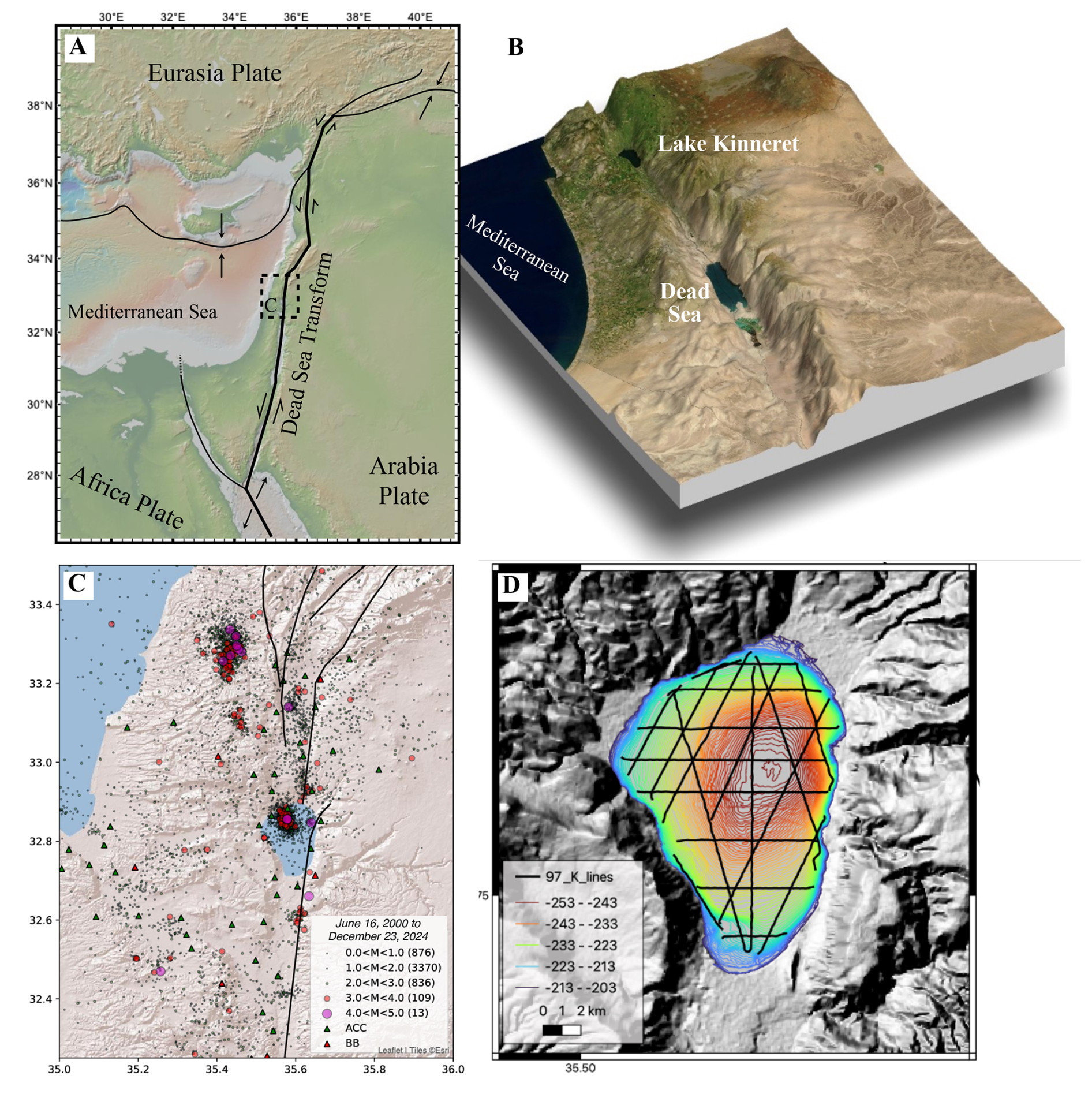
Figure 1(A) Tectonic settings of the eastern Mediterranean and Levant. (B) Landscape of the southern Levant. Note the dominance of orographic contrasts between plateau, valley, mountain range, and coastal plain (designed by Christian Ohlwein; figure modified after Litt et al., 2021). (C) Regional seismicity between 16 June 2000 and 23 December 2024 (https://eq.gsi.gov.il, last access: 8 April 2026), plotted by magnitude, with the number of earthquakes at each magnitude unit shown in the legend. The seismic stations of the Geological Survey of Israel are shown by the green and red triangles for strong motion accelerometer and broadbands (respectively). Major faults are represented by the black lines. (D) Lake bathymetry (Tibor et al., 2014), with the marine 2D seismic lines (after Hurwitz et al., 2002).
Several short cores and outcrops surrounding the lake recovered an integrated record of the last ∼ 30 kyr of lake history (Fig. 2; Hazan et al., 2005; Langgut et al., 2016; Lev et al., 2019; Schiebel and Litt, 2018; Vossel et al., 2018). In addition, the lithology and chronostratigraphy of the Kinnarot Basin sedimentary sequence, located immediately south of the modern lake (Fig. 2a), are represented by the Zemah-1 borehole, drilled on-land (Marcus and Slager, 1985). Combined with seismic reflection data (Ben-Gai, 2009; Hurwitz et al., 2002; Reznikov et al., 2004), available evidence indicates that the sedimentary record of Lake Kinneret can yield the longest and most detailed hydroclimate archive of the eastern Mediterranean–Levant, stretching as far back as ∼ 10 Ma or more. The KIND workshop focused on the potential to retrieve a highly detailed Pliocene–Quaternary sedimentary record from Lake Kinneret by drilling the depocenter of the modern lake (Figs. 1, 2). This record will be used to reconstruct a detailed history of eastern Mediterranean (EM) and Levant hydroclimate and its global teleconnections and will establish one of the longest paleoseismic records on Earth, spanning the Pliocene–Quaternary. Lake Kinneret's hydroclimate record will augment the detailed southern Dead Sea lacustrine record from the ICDP Dead Sea Deep Drilling Project (DSDDP) that covers the last ∼ 220 kyr (Goldstein et al., 2020; Torfstein et al., 2015). Further enhancing the importance of the proposed project is the fact that this region is a tectonic “hot zone” due to the activity along the DST and has served as a primary locus for the main waves of hominin, fauna, and flora migration out of Africa, as well as major cultural developments.
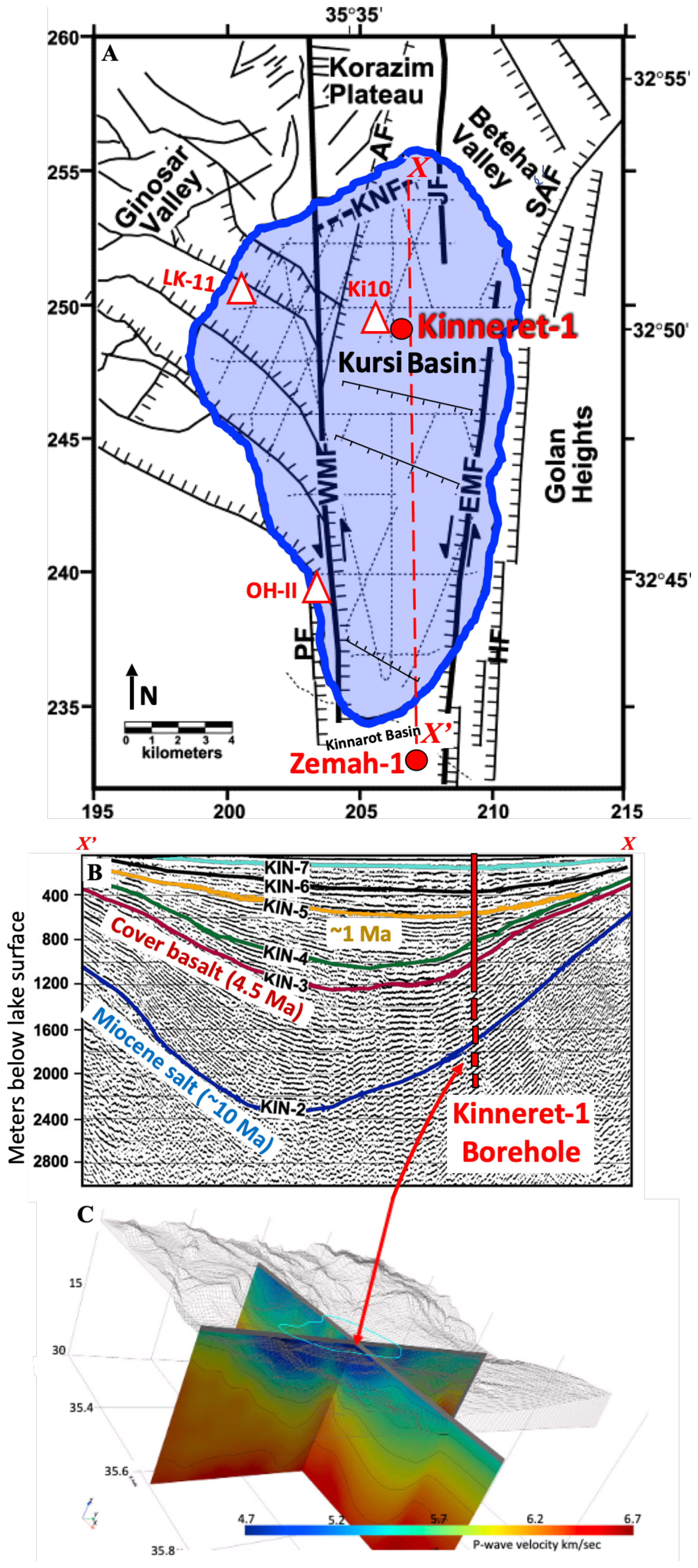
Figure 2(A) Lake Kinneret and regional faults (modified after Hurwitz et al., 2002). Also shown are the locations of the proposed deep Kinneret-1 drilling site and the on-shore Zemah-1 borehole (4.2 km deep) (red circles); shallow cores (white triangles) include OH-II (last glacial period), the Ki10 core at the lake center (Holocene), and LK11 (last 12 kyr). Fault name abbreviations: PF – Poria fault; HF – Haon fault; WMF – western marginal fault; EMF – eastern marginal fault; KNF – Kfar–Nahum fault; AF – Almagor fault; SAF – Sheikh–Ali fault. The dashed red line (X–X′) shows the location of the 2D seismic line in panel (B). (B) Seismic reflection profile (Ben-Gai, 2009; Ben-Gai and Reznikov, 1997) along the line X–X′ between the location of the Zemah-1 borehole in the south and the Kursi Basin in the north, where we propose drilling the Kinneret-1 borehole. Shallow drilling in proximity to the proposed drill site (near the lake center) was already performed in 2010 (core Ki10) and recently in 2022 (by the team of Thomas Litt and Moti Stein), both providing preliminary results that form a basis for the proposed project (Langgut et al., 2015; Schiebel and Litt, 2018; Vossel et al., 2018). The colored lines (KIN-2 to KIN-7) mark seismic reflection lines that are extended and correlated to the on-shore area near the Zemah-1 borehole, where the lithology and chronology are known (see text and references). The KIN-3 red line is correlated with the top of the Cover Basalt unit that is Ar–Ar plateau dated (in Zemah-1 and elsewhere) to ∼ 4.5 Ma. The KIN-5 yellow line is correlated to the mid–Pleistocene lacustrine sequence in Zemah-1. We mark the suggested site of the Kinneret-1 borehole, which is planned to reach the KIN-3 red marker at a depth of ∼ 1200 m. This would retrieve a full Pliocene–Quaternary lacustrine section. Further extending the drilling towards the KIN-2 marker would allow recovery of a full record from the Miocene to present. (C) Two P-wave velocity cross-sections that intersect at the proposed location of the Kinneret-1 borehole. These are based on a new 3D velocity model (Aizenshtat Soffer et al., 2026).
1.2 Background
The IPCC AR6 (Lee et al., 2023) forecasts that climate change and global warming will cause major adverse impacts on modern societies, including agriculture production; the spread of infectious diseases; harm from wildfire; human displacement; and damage to economic sectors, as well as to ecosystem structure and species range. The Mediterranean Basin is considered to be a hotspot of hydroclimate change (Cos et al., 2022; Giorgi and Lionello, 2008). Climate models consistently project that the region will become gradually drier and warmer during the 21st century, forced by the increasing concentrations of atmospheric greenhouse gases (Delworth et al., 2022; Garfinkel et al., 2020; Seager et al., 2019). Indeed, climate models and tree-ring records have already revealed an overall drying trend since the 19th century (Cook et al., 2016; Kelley et al., 2012, 2015). With the superposition of regional geopolitical strife and a growing scarcity of water, understanding of the climatic dynamics of the Levant and surrounding regions is critically important, with implications for many millions of people today and in the upcoming century. Understanding how global warming will impact future climate patterns in this region can be partly achieved through analysis of observations (e.g., instrumental records such as precipitation patterns) and the use of climate modeling. This can be augmented by understanding hydrological and ecological sensitivity to changing climate as depicted in paleorecords, which provide us with the potential to investigate the rich complexity of responses to past greenhouse forcing and its variability. Large-scale paleoclimate record compilations show that orbital-timescale climate variability in eastern Africa and western Asia has coincided with atmospheric CO2 swings (Cohen et al., 2022a, b; Otto-Bliesner et al., 2013). Nevertheless, we still lack a comprehensive understanding of how climate and ecosystem responses play out along the large-scale latitudinal differences within this region or how coupled insolation and global greenhouse gas forcing drive responses across a variety of terrains and hydrographic regimes.
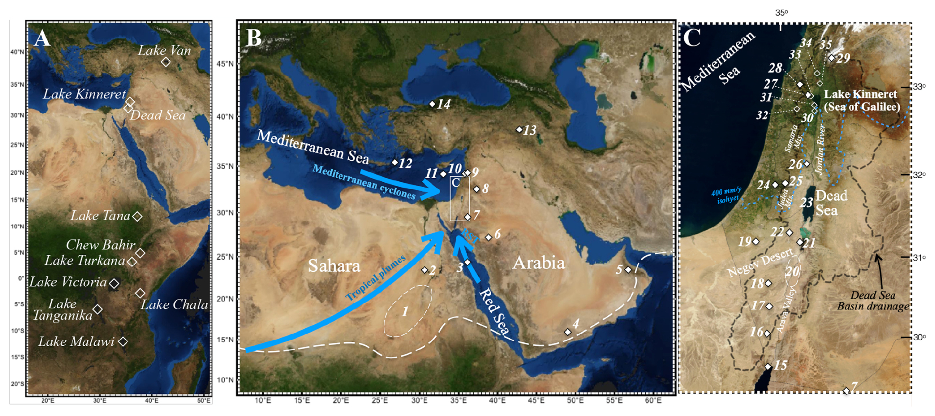
Figure 3Key paleoclimate archives and archeological sites. (A) Main lakes across and in proximity to the East African Rift–Dead Sea Transform (EARDST), including ICDP drill sites. (B) Regional location map and climate archives. The Levant is located at the intersection of the Sahara–Arabia Desert belt and the Mediterranean climate zones. The present-day northern boundary of summer precipitation related to the African and Indian Ocean monsoon rain systems is marked by a thick-dashed white line. The main systems contributing precipitation to the southern Levant are marked by blue arrows (Mediterranean cyclones, Red Sea Troughs (RSTs), and tropical plumes). (C) Southern Levant climate archives and relevant archeological sites. A dashed blue line marks the approximate locus of the 400 mm yr−1 isohyet, beyond which a steep climate gradient leads to an extreme desert environment. Currently, most of the precipitation in the northern Levant comes from the Mediterranean during the winter. The Negev Desert and Arava Valley receive minor amounts of localized rain, primarily associated with active RST systems and tropical plumes (Ziv et al., 2006). During the last interglacial, the areas that currently receive rains from EM sources were significantly drier. Locations of prominent geological archives in the region: (1) Eastern Sahara freshwater deposits (Smith et al., 2007; Szabo et al., 1995), (2) western Desert–Egypt travertines (Crombie et al., 1997), (3) Core KL23 in the northern Red Sea (Hartman et al., 2020; Palchan et al., 2013), (4) Yemen Cave (Fleitmann et al., 2011), (5) Oman Cave (Fleitmann et al., 2003), (6) Nafud Desert (Rosenberg et al., 2013), (7) South Jordan (Petit-Maire et al., 2010), (8) Azraq Oasis–Jordan (Cordova et al., 2013), (9) Lake Yammouneh (Gasse et al., 2011), (10) Jeita Cave (Cheng et al., 2015), (11) ODP Site 967 (Grant et al., 2017), (12) Core LC21 (Grant et al., 2012), (13) Lake Van (Litt et al., 2014; Stockhecke et al., 2016), (14) Sofular Cave (Fleitmann et al., 2009), (15) Gulf of Aqaba corals (Lazar and Stein, 2011; Yehudai et al., 2017), (16) Ketora Cracks (Vaks et al., 2007), (17) Ma'ale-ha-Meyshar (Vaks et al., 2007), (18) Even-Sid (Vaks et al., 2007), (19) Ashalim Cave (Vaks et al., 2007), (20) Arava Valley travertines (Livnat and Kronfeld, 1985; Waldmann et al., 2010), (21) Arubotaim Cave Amora Formation (Torfstein et al., 2009; Zak, 1967), (22) Tzavoa Cave (Vaks et al., 2006), (23) Dead Sea (see text for references), (24) Soreq Cave (Bar-Matthews et al., 2003), (25) Har Nof Cave (Frumkin et al., 2022), (26) Ma'ale Efrayim Cave (Vaks et al., 2003), (27) Zalmon Cave (Keinan et al., 2019), (28) Peqi'in Cave (Vaks et al., 2003), (29) Mt. Hermon (Ayalon et al., 2013). Prominent archeological sites near Lake Kinneret are marked by empty diamonds and include (30) 'Ubeidiya, (31) Ohalo-II, (32) Qafzeh Cave, (33) Nahal Amud Cave, (34) Eynan, and (35) Gesher Benot Ya'aqov.
The climatic and environmental history of the Levant and the EM has long been an area of interest for paleoclimatologists (e.g., Bar-Matthews, 2014; Enzel et al., 2008; Gasse et al., 2015; Grant et al., 2017; Rohling et al., 2013; Rossignol-Strick, 1985; Stein, 2014b) (Fig. 3). Over the last ∼ half century much of our understanding of this history has come from studies of regional terrestrial archives, such as speleothems from Israel (Bar-Matthews et al., 2003; Vaks et al., 2006) and Arabia (Fleitmann et al., 2003), Lake Kinneret (Hartung et al., 2025; Hazan et al., 2005; Lev et al., 2019; Schiebel and Litt, 2018; Stein, 2014a; Vossel et al., 2018), the Dead Sea (e.g., Enzel et al., 2008; Stein, 2014b; Torfstein et al., 2015), and Lake Van (Litt et al., 2014; Litt and Anselmetti, 2014; Stockhecke et al., 2016) lacustrine records. Many of these terrestrial archives capture only the late Pleistocene–Holocene or are limited in their temporal resolution and continuity but are complemented by studies of marine cores from the Red Sea (Almogi-Labin et al., 1996; Roberts et al., 2011; Stein et al., 2007), the Gulf of Aden (deMenocal, 2004; Tierney et al., 2017), and the EM (Emeis et al., 1996; Grant et al., 2017; Rossignol-Strick, 1985).
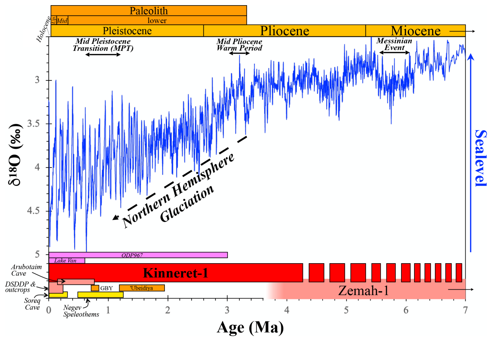
Figure 4Miocene to present oceanic oxygen isotope stratigraphy (benthic δ18O data from Zachos et al., 2001) and time span of regional archives discussed in this report. The Dead Sea records, the Dead Sea Deep Drilling Project (DSDDP) and the Arubotaim Cave outcrop (pink rectangles; Goldstein et al., 2020; Neugebauer et al., 2014; Torfstein et al., 2009, 2015), together with nearby cave deposits (yellow; Bar-Matthews, 2014; Bar-Matthews et al., 2003), provide excellent coverage of the late-Quaternary hydroclimate of the Levant. The Zemah-1 borehole south of Lake Kinneret provides rough coverage from ∼ 10 to < 4 Ma (Marcus and Slager, 1985). The proposed Kinneret-1 borehole will yield a high-resolution record of hydroclimate, magneto-stratigraphy, and paleo-seismicity, extending back to at least until the early Pliocene and possibly the Miocene. This new archive will record changes during the Mid Pliocene Warm Period and the Northern Hemisphere Glaciation in the Levant, will reveal the regional climate dynamics during the MPT, and will allow the use of these insights to interpret Paleolithic to Neolithic records (e.g., 'Ubeidiya and Gesher Benot Ya'aqov (GBY) marked by orange rectangles). Additional archives such as ODP967 in the EM and Lake Van (purple), together with lake records in East Africa (not shown here), provide wide regional context for the interpretation of the Kinneret-1 record.
Global climate has undergone significant changes since the onset of the Pliocene, with an overall shift from the relatively warm Pliocene, itself interrupted by brief early glacial excursions such as the M2 event at ∼ 3.3 Ma (De La Vega et al., 2020), to the colder Pleistocene (Filippelli and Flores, 2009; Haywood et al., 2009; Lisiecki and Raymo, 2007; Westerhold et al., 2020). Temperatures during the Pliocene were ∼ 2–3 °C higher than the pre-industrial levels (Haywood et al., 2009), peaking at up to 4 °C higher temperatures during the so-called mid-Pliocene Warm Period (mPWP; Fig. 4) (Haywood et al., 2016), with atmospheric carbon dioxide values ranging, during the Pliocene, between 350–550 ppm (Guillermic et al., 2022; De La Vega et al., 2020; Stap et al., 2016), and global sea level was likely 12–20 m higher than the present (Miller et al., 2020). Accordingly, the Pliocene – and, in particular, the mPWP – may represent potential analogues for current and near-future anthropogenic global warming scenarios (Burke et al., 2018; Haywood et al., 2020). Later, during the transition towards the Pleistocene, Northern Hemisphere Glaciation (NHG) developed (Ravelo et al., 2004; Westerhold et al., 2020) (Fig. 4), and Earth's climate entered a new stage dominated by the quasi-periodic expansion and contraction of the major NH polar ice sheets, driven by variations in the Earth's axial inclination and orbital geometry (Milankovitch, 1941). However, the frequency, amplitude, and shape of these glacial–interglacial cycles were not uniform, and the ∼ 41 kyr periodicity that dominated the Early Pleistocene turned into the ∼ 100 kyr higher-amplitude and strongly saw-toothed cycles (Fig. 4) during the Mid-Pleistocene Transition (MPT) between ca. 1.2 Ma and 600 ka (Head and Gibbard, 2015). In addition to orbital-scale variability, North Atlantic and polar records revealed the extreme and pervasive nature of millennial-scale climate variability over the last 800 kyr (Barker et al., 2011; Jouzel et al., 2007; McManus et al., 1999), with mounting evidence showing that such events extended into the early Pleistocene (Naafs et al., 2013; Raymo et al., 1989).
1.2.1 Neogene–Quaternary waterbodies in the Kinneret Basin
The early-Neogene landscape of the southern Levant was characterized by low relief and large drainage systems that drained into the EM. With the development of the Dead Sea Transform (DST) during the Miocene and formation of the tectonic and topographic depressions along the Jordan Valley (the Kinneret and Dead Sea Basins; Fig. 2) the drainage systems changed their direction towards the new topographic depressions. The Zemah-1 borehole (Fig. 5) recovered a ∼ 4.2 km thick section that serves as a preliminary reference for the proposed drilling. It consists of lacustrine sediments, volcanics, and salts (halite) that accumulated in the Kinneret Basin over the last ∼ 10 Myr (Marcus and Slager, 1985; Segev, 2017; Stein, 2014a). The lower and middle parts of Zemah-1 comprise the Tortonian Bira Fm. and the Messinian Gesher Fm. that were deposited from Lake Bira and from the Gesher swamps, respectively (Rozenbaum et al., 2019, 2022; Stein, 2014a). The upper part of the Zemah-1 section comprises lacustrine sequences that were deposited during the Pliocene–Quaternary (after the Zanclean Transgression at ∼ 5.3 Ma).
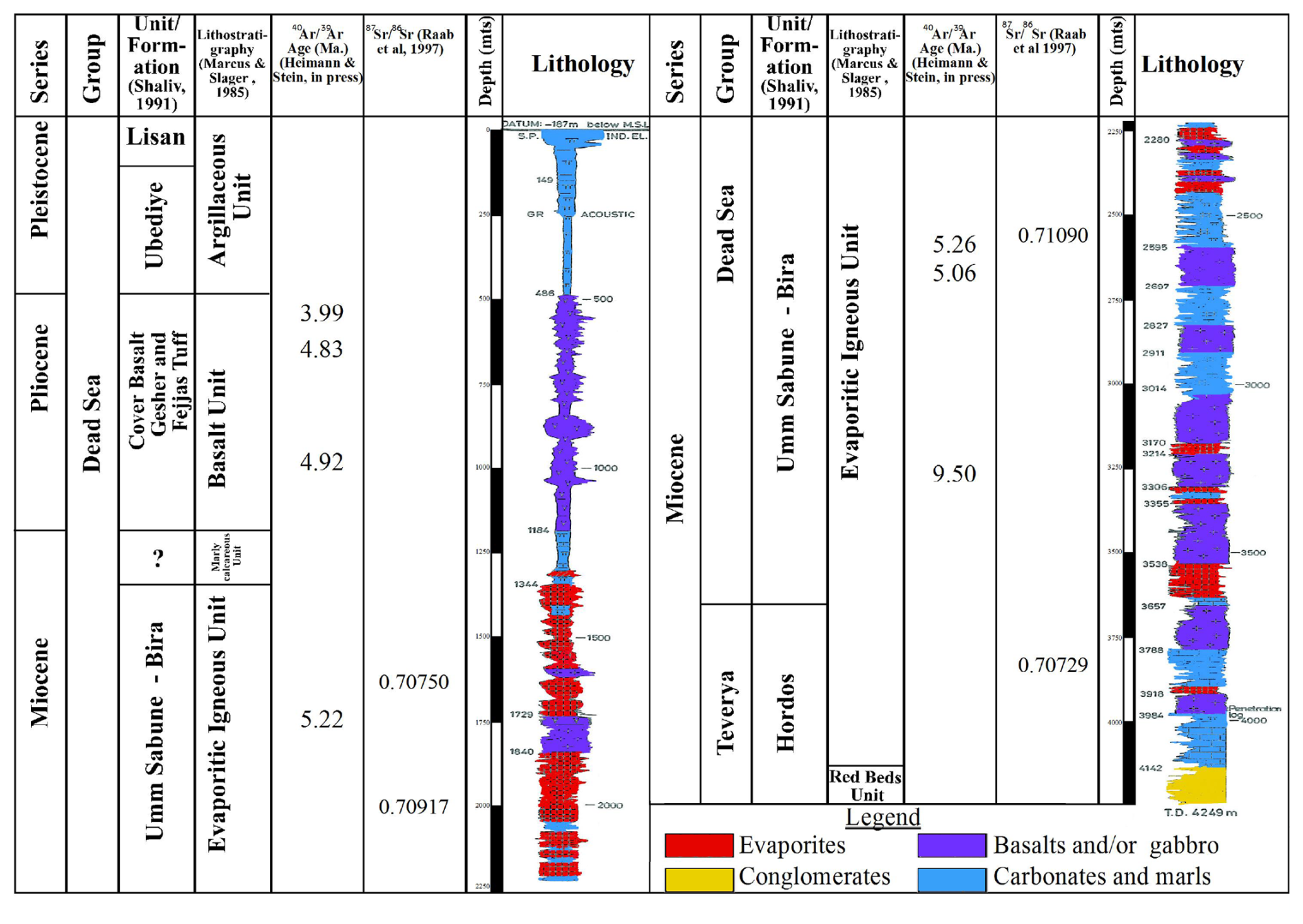
Figure 5Columnar section of the on-shore Zemah-1 drillhole with 40Ar 39Ar ages and 87Sr 86Sr values (modified after Marcus and Slager, 1985, and Raab et al., 1997). Ages are Ar–Ar plateau ages on basalt flows (Heimann and Stein, unpublished data). See the location of Zemah-1 in Fig. 2. The cuttings provide background information (e.g., lithology and chronology) for the proposed Kinneret-1 drilling. Note that, while the Zemah-1 borehole provides important constraints on the chronostratigraphy of the Kinneret-1 site based on subsurface correlations (Fig. 2B), the geological context and lithology at both sites are different. The primary target at the Kinneret-1 site is the section above the Cover Basalt (Pliocene to present), which is dominated by carbonates and marls.
Over the last ∼ 3 Myr, terminal and hypersaline lakes filled the tectonic depression of the Dead Sea Basin (DSB) along the southern segment of the DST (e.g., lakes Amora, Samra, Lisan, Dead Sea; Stein, 2014b; Torfstein et al., 2009; Zak, 1967). The sediments that accumulated in these lakes reflect the environmental–hydrological conditions of a large watershed, extending between the Sahara–Arabia deserts in the south and the Mediterranean climate zone in the north (separated roughly by a dashed blue line in Fig. 3). The DSB lakes received water and sediments from the entire watershed, including the southern, currently hyperarid deserts. In contrast, Lake Kinneret is an open lacustrine system, which is supplied mainly by the Jordan River and its northern tributaries, whose hydrology is completely controlled by and reflects the Mediterranean climate zone. This unique configuration of a “chained lake system” – a cascade of tectonically linked freshwater and hypersaline lakes, connected to one another yet each nourished by distinct sources – opens the possibility to study the regional hydroclimate history along a unique north-to-south transect and allows exploration of the effects of the global “climate engines” on the regional hydrological systems in the two climate zones.
1.2.2 Tectonic setting and structural framework of Lake Kinneret Basin
The Kinneret Basin is a pull-apart structure located along the DST, a ∼ 1000 km long left-lateral strike–slip plate boundary separating the Arabian plate from the Sinai sub-plate (Fig. 1A) (Garfunkel, 1981; Quennell, 1958; Weber et al., 2009; Zak and Freund, 1981). Its evolution has been characterized by a cumulative northward displacement of approximately ∼ 105 km (Freund et al., 1970; Quennell, 1958), representing an average slip rate of ∼ 5 mm yr−1 since the Miocene, which is compatible with modern geodetic measurements (Sadeh et al., 2012). The recent seismicity regime of the Kinneret area is characterized by moderate to high activity (Fig. 1C), reflecting the ongoing crustal deformation along the plate boundary (Barnea Cohen et al., 2022; Ben-Avraham et al., 1996; ten Brink et al., 2023; Gasperini et al., 2020; Hurwitz et al., 2002). However, historical records indicate the occurrence of destructive earthquakes such as those of 749, 1033, and 1202 CE (Ambraseys, 2009). Paleo- and archeo-seismic studies show that these earthquakes originated along the DST (Ellenblum et al., 2015; Wechsler et al., 2014). Locally, the Kinneret Basin exhibits frequent low-magnitude microseismicity (ML < 3.0) and occasional moderate swarms, often concentrated along the western and eastern boundary faults (Wetzler et al., 2019).
The Kinneret Basin morphology is governed by the interaction of the main N–S-trending transform faults and a series of E–W- to NW–SE-trending normal faults (Figs. 1, 2) that accommodate the internal subsidence of the basin (Ben-Avraham et al., 1996). The main depocenter, the Kursi Basin (Fig. 2A), is characterized by asymmetric subsidence, with the deepest sedimentary fill reaching several kilometers in thickness. This subsidence is driven by a transtensional tectonic regime promoted by a step-over between the East Longitudinal Fault and the Jordan Gorge Fault (ten Brink et al., 2023). The fast long-term subsidence makes it a unique archive of environmental characteristics manifested in the sediments and their deformation features, e.g., seismites.
The internal structure of the rhomb-shaped graben that forms the Kinneret Basin is obtained from a compilation of independent geological and geophysical studies (Aizenshtat Soffer et al., 2026), indicating a > 5 km deep fault-bounded sub-basin filled with sediments (Fig. 2) and basalt flows. Seismic reflection data highlight the subsided structure, where the 3D seismic tomography model (Fig. 2C) shows a regional segmentation of the subsided sedimentary structure into three sub-basins. The central sub-basin is associated with the Kursi Basin, indicating relatively low seismic velocities which reflect the Plio–Pleistocene subsidence of the basin.
1.2.3 Human evolution and hominin occupation in the Kinneret Basin
Climate change has been proposed as a primary driver of human evolution, habitat divergence, dietary innovations, and long-distance dispersals (Behrensmeyer, 2006; Blome et al., 2012; deMenocal, 1995; Gasse, 2000; Stewart and Stringer, 2012; Timmermann et al., 2024). However, only limited evidence is available to assess hominin adaptations to environmental changes during key evolutionary stages such as the Early Pleistocene, when hominins first dispersed out of Africa. This gap hinders our ability to address questions that are currently under ongoing research debate, such as the following: (1) Is climate variability/climate instability the prime motivator (or inhibitor) behind hominin dispersals? (2) What were the climate conditions in the currently hyper-arid regions separating East Africa and the Levantine corridor during the Pleistocene? (3) What was the Early-Pleistocene vegetation cover in the northern sections of the DST (extent of forests vs. grasslands)? (4) What was the degree of hominin adaptability to ecological variations? Because the Levantine Corridor was a primordial route for northward hominin migration, its environmental history is key to understanding the interplay between early hominin evolution and adaptation patterns in relation to climate change. The KIND project is uniquely positioned to fill these research gaps as it will offer a unique continuous high-resolution environmental record found in an immediate context with early hominin artifacts (e.g., Lower Paleolithic).
The Kinneret Basin serves as a key segment of the Levantine Corridor since it provides a rare combination of fresh water, diverse flora, and abundant fauna facilitating long-term habitation and intermittent migrations of various Homo species (Bar-Yosef and Belfer-Cohen, 2001). The Kinnarot Basin, located immediately south of the modern lake (Fig. 2a), hosts one of the earliest records of Early-Pleistocene tool-making outside of Africa, the 'Ubeidiya site (Bar-Yosef and Tchernov, 1972; Matmon et al., 2026) (Fig. 3). The exposed sedimentary section at 'Ubeidiya includes cyclic intercalations of lacustrine sediments with fluvial and alluvial units, recording repeating episodes of the lake's transgressions and regressions (Picard and Baida, 1966). The terrestrial layers of 'Ubeidiya yielded rich lithic assemblages of the Early-Acheulian type (Bar-Yosef et al., 1993), an abundance of faunal remains (Martínez-Navarro et al., 2012), and very limited plant remains (Lorch, 1966). The few hominin remains that were exposed indicate that the site preserves traces of one of the earliest migrations of hominins out of Africa (Barash et al., 2022). The paleoenvironmental reconstructions based on zooarcheological findings have produced conflicting results regarding the degree of savanna vs. forest landscape composition, hindering our ability to fully consider environmental contributions to Early-Pleistocene hominin dispersals (Tchernov, 1988). While Tchernov (1988) suggested that the site is dated to approximately 1.6–1.2 Ma, a recent study proposes, based on combined cosmogenic nuclide dating, paleomagnetic analyses, and U–Pb ages, an even older age of ca. > 1.9 Ma (Matmon et al., 2026).
Further north, along the Jordan River, the site of Gesher Benot Ya'aqov (GBY), which was occupied between ∼ 800–700 ka, provides critical insights into Middle-Acheulian culture. GBY is renowned for the exceptional preservation of botanical remains, including several thousands of seeds, which offer a rare glimpse into the plant-based diet of early hominins. Among the wood remains, a human-made wooden tool was identified, one of the oldest in the world (Goren-Inbar et al., 2004). The pollen assemblage allowed for the reconstruction of glacial and interglacial periods during the site's existence. Furthermore, the bifacial tools at GBY, often fashioned from basalt, indicate sophisticated cognitive abilities and a systematic approach to tool production (Fig. 3).
During the Middle Paleolithic (∼ 250–50 ka), the region saw the co-existence or alternating occupation of Neanderthals and Anatomically Modern Humans (AMHs) (Jöris et al., 2011). The Mousterian industry, characterized by the Levallois technique, is prevalent in several cave and open-air sites surrounding the basins (Shea, 2003). The proximity of Qafzeh Cave (AMH remains, ca. 100 ka; Vandermeersch and Bar-Yosef, 2017) and Nahal Amud Cave (Neanderthal remains, ∼ 70–50 ka; Hovers et al., 1995) to Lake Kinneret ensured that these hominins utilized the DST resources. North of Lake Kinneret, the open-air site Nahal Mahanayeem Outlet, dated to ∼ 65–60 ka, was occupied by AMHs and is also characterized by exceptional preservation of organic material (Kalbe et al., 2015), similarly to other archeological sites located along the northern sections of the DST.
The Pleistocene record in the Kinneret Basin (the Epipaleolithic period) encompasses the Ohalo II site (Nadel et al., 2012). This ∼ 23 kyr old submerged fisher camp, which is located on the southwestern shore of Lake Kinneret, provides valuable data on the transition from mobile foraging to sedentary life due to its excellent preservation. The site contains the earliest known brush huts, several in situ burials and hearths, and over 150 000 charred seeds, demonstrating that hunter–gatherers in the Kinneret Basin were harvesting and processing wild cereals long before the “Neolithic Revolution” (Nadel et al., 2012). At the nearby Jordan River Dureijat site (∼ 20–10 ka) a pollen-based model yielded information on the last glacial–interglacial transition, including changes in seasonality, temperature, and precipitation (Langgut et al., 2021). The Natufian (15–11.5 ka) site Eynan (Mallaha, to the north of Lake Kinneret) displays one of the world's earliest records of dog domestication (Fig. 3; Belfer-Cohen, 1991).
Human settlement patterns were evidently related to regional hydroclimatic shifts, though the nature of this connection remains uncertain. Indeed, the above descriptions of the evolution and spread of hominins and humans in this area lack a clear understanding of the concurrent environmental and climatic conditions that dominated this area prior to and throughout the Quaternary. Closing this knowledge gap is critical for a full understanding of prehistoric behavior and capabilities and of whether their spread was modulated by or independent of climate fluctuations (e.g., glacial–interglacial cycles).
1.3 Proposed KIND project drilling site
The proposed Kinneret-1 drilling site is located in the depocenter of the modern Lake Kinneret at a water depth of 38 m in the northern sub-basin of Lake Kinneret, the Kursi Basin (Fig. 2; Ben-Avraham et al., 1996, 1990; Rosenthal et al., 2019). The Kursi Basin is formed by an asymmetric half-graben delimited by the eastern longitudinal fault and, to the west, by large deformations (Reznikov et al., 2004). It is filled by a ∼ 5 km thick sequence of lacustrine sediments and basaltic flows, including the “Cover Basalt” unit, whose top was dated to ∼ 4.5 Ma (Rozenbaum et al., 2016; Shaliv, 1991). The Cover Basalt spreads over the Galilee and Golan Heights and was recovered by the Zemah-1 borehole (Fig. 5; Marcus and Slager, 1985). Above the Cover Basalt, the seismic data in the proximity of the lake center indicate an overall undisturbed sedimentary sequence. In the KIND project we aim to reach the top of the Cover Basalt, which will yield a continuous record over the last ∼ 4.5 Myr. If possible, we will recover deeper sequences, potentially reaching as far back as ∼ 9–10 Ma. The basin stratigraphic architecture (Fig. 2) is a major advantage of the site, enabling numerous suitable drilling scenarios including a transect of shallower off-shore and on-shore boreholes. The drilling strategy can be optimized to fit project funding while reaching priority objectives.
Regarding justification for the site selection, the site has the potential for a very high-resolution (up to 1 m kyr−1 for the younger section) continuous record of Mediterranean climate spanning the last ∼ 4.5 Myr (expanding the 220 kyr from the DSDDP site by an order of magnitude). The time interval targeted encompasses important transitions of climate, from a world dominated by warm temperatures with limited temperature amplitude changes at the beginning of the Pliocene (after the Messinian Salinity Crisis) to a warm 41 kyr old world with higher temperatures and temperature fluctuations following the intensification of NHG at 2.7 Ma and then through the MPT (∼ 1.2–0.6 Ma) to the much colder 100 kyr old world with large-amplitude temperature changes since ∼ 0.9 Ma (Clark et al., 2024; Fig. 4). The area is crucial for the study of hominin migration and represents the cradle of agriculture development. The drilling would allow us to decipher the global and regional records and to link the site to global forcing mechanisms (e.g., northern- vs. southern-latitude influence, Indian monsoon and migration of rain belts) and to provide constraints for climate model simulations and estimates of climate sensitivity. It would provide a framework for assessing climate variability impacts on water resources and how these shaped hominin/human activity in the region. In other words, the site will allow us to illuminate the interactions and feedbacks between climate, human, and ecological evolution; tectonics; volcanism; and geomagnetism. The site lies along a continuous chain of lake records, many of which have been drilled as part of previous ICDP projects. These extend from Lake Malawi in the south through Lakes Chala, Turkana, Chew Bahir, the Dead Sea, Lake Kinneret, and Lake Van in the north (Fig. 3), providing a longitudinal hydroclimate transect, as well as a latitudinal transect from the Levant and Türkiye to Lake Ohrid in the west. Correlations and integration with the many documented outcrops at local and regional scales are also feasible and necessary to achieve the goals of this project.
Drilling within an active tectonic setting will improve our understanding of the evolution of the plate boundary and the rate of seismicity. The deployment of permanent borehole sensors will establish a unique observatory along an active plate boundary, which is relevant to assessing geohazards. The high-resolution paleomagnetism could shed light on the dynamics of the geomagnetic field during excursions and reversals at a centennial to sub-centennial resolution, thereby resolving longstanding fundamental ambiguities in the global paleomagnetic record (Channell et al., 2020; Mahgoub et al., 2023; Valet and Fournier, 2016). This is the basis for understanding the temporal dynamics of the transitions in the geomagnetic field and can serve as a high-resolution method for global chronostratigraphic resolution and correlation, as well as the impacts of changes in the magnetic field on life on Earth and the global climate.
Funding was awarded by ICDP in 2024, and the workshop was convened in July 2025 in Potsdam, Germany. The workshop hosted 61 participants from 12 countries (China, Germany, Iceland, Israel, Italy, Japan, Spain, Switzerland, Türkiye, the United Kingdom, the United Arab Emirates, and the United States) and 33 different universities and research institutes, as well as representatives from the ICDP Operational Support Group (OSG). The workshop tasks were to define scientific priorities and analyses, logistics, drilling targets, downhole logging measurements, and education and outreach plans for a scientific drilling project in Lake Kinneret. The first half of the workshop consisted of presentations that focused on the scientific background and history of Lake Kinneret: geology, limnology, hydrology, tectonics, paleoclimate, paleoecology, and regional history of hominins. Subsequently, the participants discussed the scientific questions, hypotheses, objectives, and approaches relevant to the KIND project, as well as the analyses and methods required. These discussions took place in breakout groups and were then further refined in a full-forum discussion. The synthesis of these discussions is summarized in Sect. 3 below.
3.1 Overarching motivation
The KIND project aims to construct a globally unique reference record of the climatic, environmental, seismic, and geomagnetic history of the Levant over the last ∼ 4–5 Myr. This reference record will be highly resolved (tracing sub-centennial changes in the calcite-dominated lacustrine intervals that dominate most of the sedimentary column), continuous, and supported by a wealth of previous knowledge from the same region. The KIND record is expected to provide transformative insights regarding (1) the spatio-temporal dynamics of regional hydroclimate that primarily reflect the Mediterranean climate regime and its relation to global climate patterns during the Pliocene–Quaternary and (2) seismic activity along the DST, as well as (3) a high-resolution paleomagnetic record that will allow us to explore in detail the global behavior of the geomagnetic field across reversals and excursions.
The KIND project builds on existing regional records, which will enhance the new findings. These include the ICDP Dead Sea project that retrieved 220 kyr of a hydroclimate and paleoseismic record and the Zemah-1 borehole that reaches ∼ 10 Myr and provides important lithological information and chronostratigraphic constraints for the proposed borehole, together with ODP Site 967 in the EM that covers the last 3 Myr (Grant et al., 2017). The stratigraphy and general chronology of the proposed drilling site are tentatively interpreted from seismic reflection transects between the Zemah-1 borehole and the Kursi Basin and a recent earthquake tomography of the Kursi Basin (Figs. 2, 5). The proposed KIND project will significantly extend existing proxy records across the EM and the Levant.
Achieving the above-mentioned goals will allow us to create a globally unique record of Pliocene–Quaternary terrestrial climate in a highly important region, the Levant, coupled with a comprehensive paleoseismic and paleomagnetic record. Combined, the proposed KIND project (covering ∼ 4–5 Ma) and the ICDP-Dead Sea record (covering 220 ka) will provide detailed Plio-Quaternary continental, mid-latitude hydroclimate, paleomagnetic, and paleoseismic records from both sides of the Mediterranean–desert climate boundary. The products of the KIND project will lead to a substantial number of high-impact publications across paleoclimatology, seismology, geomagnetism, archeology, and more and will provide a suite of extremely relevant societal benefits, including critical knowledge for regional water resource management, seismic hazard assessment, and climate adaptation planning.
3.2 Working hypotheses
We hypothesize that the Levant and eastern Mediterranean were relatively drier during the warm Pliocene and became gradually wetter during the Quaternary. We further hypothesize that this “wetting” is controlled by two large-scale processes that occurred throughout the Pliocene–Quaternary:
- i
the Northern Hemisphere Glaciation, which initiated as early as 3.6 Ma and intensified at 2.7 Ma (McClymont et al., 2023), is postulated, based on the sensitive regional climate response to global trends during the Quaternary, to have caused a gradual change in the EM–Levant hydroclimate, as is indeed reflected by the Plio-Pleistocene aridification of the Sahara (deMenocal, 2004; Trauth et al., 2009, 2021; Zhang et al., 2014);
- ii.
the long-term regional landscape evolution associated with the development of the Dead Sea Transform (DST) resulted in the development of the central mountain ridge (e.g., Judea and Samaria Hills and the Galilee Mountains), which imposed a strong local orographic effect.
Currently, there is scarce evidence to challenge the above hypotheses due to the lack of appropriate climate archives, which inhibits a more detailed evaluation of the impacts of both processes on pre-Quaternary Levant climate. The second process is related to the long-term evolution of the East African Rift–Dead Sea Transform (EARDST) and the shaping of the surrounding landscape and large drainage systems (e.g., the Nile River). The EARDST accommodated the early development and migration of hominins out of Africa. Several of the most important prehistoric archeological sites are located near the proposed drilling site (Fig. 3).
- iii.
Lake Kinneret deposits are susceptible to earthquake shaking, thereby enabling the recovery of seismite records (Lu et al., 2020) that document the seismic–tectonic evolution of the DST without significantly disrupting the overall continuity of the sedimentary sequence.
3.3 Scientific goals
The primary goal of the KIND project is to establish a Pliocene–Quaternary chronostratigraphic reference record of the EM–Levant at a sub-centennial resolution, which will include a hydroclimate record, a paleoseismicity record, and a geomagnetic record. Each of these will be motivated by a series of specific scientific questions and will be based on proxy reconstructions; combined, the results will shed light on human prehistory and history:
- i
Hydroclimate. Proxy-based reconstructions will use pollen and biomarkers, mineralogy, elemental abundances and stable and radiogenic isotopic compositions of both sediments and porewaters, and hydroclimate models. The results will be used to pursue the following specific objectives:
- a.
compare Pliocene–Quaternary hydroclimate patterns between northern and southern Israel (reflecting Mediterranean versus desert climate zones, respectively);
- b.
determine the timing of major Pliocene–Quaternary climate changes in the Levant region and evaluate lags and leads relative to global records;
- c.
compare the KIND hydroclimate record to climate model simulations of the Pliocene (PlioMIP2 and the upcoming PlioMIP3, which includes the early Pliocene);
- d.
calibrate transient climate models using the KIND hydroclimate record and extend transient climate models to the Pliocene;
- e.
building on hydroclimate records and modeling, establish a quantitative predictive model of regional hydroclimate for the 21st century.
- a.
- ii.
Paleoseismicity. A record of seismicity across the DST will be established from the Pliocene.
- iii.
Geomagnetic record. We will generate a continuous, precisely dated geomagnetic record of reversals and excursions since the Pliocene at sub-centennial temporal resolution.
- iv
Prehistory and human evolution. The cores will provide new insights into human prehistory, more specifically
- a.
the connection between prehistoric migration patterns and regional hydroclimate;
- b.
the connection between historic cultural developments and regional hydroclimate, as well as possible connections to the impacts of earthquakes on cultural development.
- a.
- v.
Significant public outreach and Diversity, Equity, and Inclusion (DEI) activities. Efforts will include the development of educational outreach opportunities, including public talks, science exhibitions, and the production of short documentaries that explain our findings and their implications for the future climate. In addition, the scientific results of the project will be used to develop technical short-course training to develop high-school-level paleoclimate teaching modules for underprivileged students.
3.4 Meridional continental paleoclimate transect
The upper sequence of the proposed Kinneret-1 record overlaps chronologically with the ∼ 600 kyr sequence recovered by the ICDP Lake Van drilling project (Litt and Anselmetti, 2014). Lake Van is situated at the crossroads of the atmospheric southwestern jet stream and the northern branch of the subtropical high-pressure belt. Its sedimentary record is therefore a key archive for reconstructing Quaternary hydroclimate evolution in the Levant (Litt et al., 2014; Litt and Anselmetti, 2014; Stockhecke et al., 2016). The comparison between Lake Van and Lake Kinneret over the last 600 kyr, combined with the Dead Sea record of the last 220 kyr, would provide an integrated picture of hydroclimate variations over three climate zones and their mutual impacts. These include (Fig. 3) (1) the southern extension of the northeastern European and Asian dry continental climate zone; (2) the Mediterranean zone dominated by deep-pressure cyclones; and (3) the northern extension of the desert climate zone, which has been affected by tropical storms and, occasionally, monsoonal systems. Moreover, the Lake Van–Lake Kinneret–Dead Sea transect comprises the northern segment of the EARDST that extends from East Africa to eastern Türkiye. Several lakes that are located along the EARDST have been drilled during the last few decades with ICDP funding (Cohen et al., 2016, 2022a, b). Thus, Lake Kinneret comprises an essential link within the different segments of the EARDST transect, one with the potential to yield a highly resolved record extending across the Pliocene–Quaternary times. The data retrieved from the proposed Kinneret-1 drilling would extend the scope of EARDST integration to the Early Pleistocene and even Pliocene times. Moreover, it will be a key component in the understanding of human culture development and the migration of prehistoric hominins out of Africa along this corridor.
There was a consensus among the participants that the KIND project is unique in its importance for answering primary new scientific questions relating to paleoclimate, paleoecology, paleoseismicity and tectonics, paleomagnetism, hydrology, and archeology, as well as being a strong component of outreach and education.
The workshop allowed us to refine and expand the objectives of the project and to define the knowledge gaps and overall strategy for the next steps of the project. Importantly, the workshop brought together, in many cases, for the first time, scientists from different backgrounds and disciplines, not only yielding important knowledge transfer but also creating a strong multidisciplinary and international group that is working together under the auspices of the KIND project.
No data sets were used in this article.
Eshly Aizenshtat-Soffer (Geological Survey of Israel, Jerusalem, Israel), Sena Akçer-Ön (Muğla SK University, Muğla, Turkey), Mohammad Alsuwaidi (Khalifa University, Abu Dhabi, United Arab Emirates), Gilad Antler (Ben Gurion University, Beer Sheva, Israel), Simon Armitage (Royal Holloway University of London, Egham, UK), Moshe Armon (Hebrew University of Jerusalem, Jerusalem, Israel), Sarit Ashkenazi-Polivoda (Dead Sea-Arava Science Center, Neve Zohar, Israel), Catherine Beck (Hamilton College, Clinton, NY, USA), Yaron Beeri-Shlevin (Israel Oceanographic and Limnological Research, Migdal, Israel), Michela Biasutti (LDEO, Columbia University, Palisades, NY, USA), Cecile Blanchet (GFZ Helmholtz Centre for Geosciences, Potsdam, Germany), Revital Bookman (Haifa University, Haifa, Israel), Lisa Park Boush (University of Connecticut, Storrs, CT, USA), Chunzhu Chen (Nantong University, Nantong, China), Yehouda Enzel (Hebrew University of Jerusalem, Jerusalem, Israel), Galina Faerstein (Geological Survey of Israel, Jerusalem, Israel), Markus Fischer (University of Potsdam, Potsdam, Germany), Yonatan Goldsmith (Hebrew University of Jerusalem, Jerusalem, Israel), Steven L. Goldstein (LDEO, Columbia University, Palisades, NY, USA), Hannah Hartung (University of Cologne, Cologne, Germany), Daniel Ibarra (Brown University, Providence, RI, USA), Oded Katz (Geological Survey of Israel, Jerusalem, Israel), Rolf Kipfer (EAWAG, Dübendorf, Switzerland), Yael Kiro (Weizmann Institute, Rehovot, Israel), Junko Kitagawa (Fukui Prefectural Varve Museum, Wakasa, Japan), Monika Korte (GFZ Helmholtz Centre for Geosciences, Potsdam, Germany), Dafna Langgut (Tel Aviv University, Tel Aviv, Israel), Elan Levy (Geological Survey of Israel, Jerusalem, Israel), Oded Liran (Israel Oceanographic and Limnological Research, Migdal, Israel), Thomas Litt (University of Bonn, Bonn, Germany), Shmuel Marco (Tel Aviv University, Tel Aviv, Israel), Ilaria Mazzini (Istituto di Geologia Ambientale e Geoingegneria, Rome, Italy), Steffen Mischke (University of Iceland, Reykjavík, Iceland), Mario Morellon Marteles (Universidad Complutense de Madrid, Madrid, Spain), Leicher Niklas (University of Cologne, Cologne, Germany), Anders Noren (Continental Scientific Drilling Facility, Minneapolis, MN, USA), Perach Nuriel (University of Geneva, Geneva, Switzerland), Sanja Panovska (GFZ Helmholtz Centre for Geosciences, Potsdam, Germany), Adina Paytan (UC Santa Cruz, Santa Cruz, CA, USA), Simona Pierdominici (GFZ Helmholtz Centre for Geosciences, Potsdam, Germany), Yair Rinat (Geological Survey of Israel, Jerusalem, Israel), Elena Robakiewicz (University of Cologne, Cologne, Germany), Patricia Roeser (University of Bonn, Bonn, Germany), Ron Shaar (Hebrew University of Jerusalem, Jerusalem, Israel), Sophie Roud (GFZ Helmholtz Centre for Geosciences, Potsdam, Germany), Markus Schwab (GFZ Helmholtz Centre for Geosciences, Potsdam, Germany), Eyal Shalev (Geological Survey of Israel, Jerusalem, Israel), Edo Sirota (Geological Survey of Israel, Jerusalem, Israel), Mordechai Stein (Hebrew University of Jerusalem, Jerusalem, Israel), Shaked Stein (Israel Oceanographic and Limnological Research, Migdal, Israel), Zvi Steiner (GEOMAR, Kiel, Germany), Camille Thomas (University of Bern, Bern, Switzerland), Rik Tjallingii (GFZ Helmholtz Centre for Geosciences, Potsdam, Germany), Adi Torfstein (Hebrew University of Jerusalem, Jerusalem, Israel), Martin Trauth (University of Potsdam, Potsdam, Germany), Arne Ulfers (LIAG Institute for Applied Geophysics, Hannover, Germany), Nicolas Waldmann (Haifa University, Haifa, Israel), Yishai Weinstein (Bar-Ilan University, Ramat Gan, Israel), Nadav Wetzler (Geological Survey of Israel, Jerusalem, Israel), Charlotte Zachow (Universität Tübingen, Tübingen, Germany), Alon Zask (Israel Oceanographic and Limnological Research, Haifa, Israel).
All co-authors contributed to the conceptualization of the manuscript, and reviewed and edited the manuscript. A.T. prepared the original draft of the manuscript.
The contact author has declared that none of the authors has any competing interests.
Publisher's note: Copernicus Publications remains neutral with regard to jurisdictional claims made in the text, published maps, institutional affiliations, or any other geographical representation in this paper. The authors bear the ultimate responsibility for providing appropriate place names. Views expressed in the text are those of the authors and do not necessarily reflect the views of the publisher.
We would like to thank the ICDP for the financial support and for hosting the KIND workshop in Potsdam.
The KIND workshop was supported by the ICDP.
This paper was edited by Hendrik Vogel and reviewed by Mathieu Schuster and one anonymous referee.
Aizenshtat Soffer, E., Ben Dor, G., Kurzon, I., Agnon, A., Koulakov, I., Polozov, A., and Wetzler, N.: The transition from a symmetric to an asymmetric basin structure, an example from the Dead Sea fault system, in review, Tectonics, 2026.
Almogi-Labin, A., Hemleben, C., Meischner, D., and Erlenkeuser, H.: Response of Red Sea deep-water agglutinated foraminifera to water-mass changes during the Late Quaternary, Mar. Micropaleontol., 28, 283–297, https://doi.org/10.1016/0377-8398(96)00005-9, 1996.
Ambraseys, N.: Earthquakes in the Mediterranean and Middle East: a multidisciplinary study of seismicity up to 1900, Cambridge University Press, ISBN 978-0-521-87292-8, 2009.
Armon, M., Morin, E., and Enzel, Y.: Overview of modern atmospheric patterns controlling rainfall and floods into the Dead Sea: Implications for the lake's sedimentology and paleohydrology, Quat. Sci. Rev., 216, 58–73, https://doi.org/10.1016/j.quascirev.2019.06.005, 2019.
Ayalon, A., Bar-Matthews, M., Frumkin, A., and Matthews, A.: Last Glacial warm events on Mount Hermon: the southern extension of the Alpine karst range of the east Mediterranean, Quat. Sci. Rev., 59, 43–56, https://doi.org/10.1016/j.quascirev.2012.10.047, 2013.
Barash, A., Belmaker, M., Bastir, M., Soudack, M., O'Brien, H. D., Woodward, H., Prendergast, A., Barzilai, O., and Been, E.: The earliest Pleistocene record of a large-bodied hominin from the Levant supports two out-of-Africa dispersal events, Sci. Rep., 12, 1721, https://doi.org/10.1038/s41598-022-05712-y, 2022.
Barker, S., Knorr, G., Edwards, R. L., Parrenin, F., Putnam, A. E., Skinner, L. C., Wolff, E., and Ziegler, M.: 800 000 Years of Abrupt Climate Variability, Science, 334, 347–351, https://doi.org/10.1126/science.1203580, 2011.
Bar-Matthews, M.: History of Water in the Middle East and North Africa, in: Treatise on Geochemistry, Elsevier, vol. 14, 109–128, https://doi.org/10.1016/B978-0-08-095975-7.01210-9, 2014.
Bar-Matthews, M., Ayalon, A., Gilmour, M., Matthews, A., and Hawksworth, C. J.: Sea–land oxygen isotopic relationships from planktonic foraminifera and speleothems in the Eastern Mediterranean region and their implication for paleorainfall during, Geochim. Cosmochim. Acta, 67, 3181–3199, 2003.
Barnea Cohen, O., Cesca, S., Dahm, T., Hofstetter, A., Hamiel, Y., and Agnon, A.: Seismicity induced at the northern Dead Sea Transform Fault, Kinneret (Sea of Galilee) Basin, by shallow creep involving a salt body, Tectonics, 41, e2022TC007247, https://doi.org/10.1029/2022TC007247, 2022.
Bar-Yosef, O. and Belfer-Cohen, A.: From Africa to Eurasia – Early dispersals, Quat. Int., 75, 19–28, https://doi.org/10.1016/S1040-6182(00)00074-4, 2001.
Bar-Yosef, O. and Tchernov, E.: On the Palaeo-ecological history of the site of 'Ubeidiya, Isr. Acad. Sci. Humanit., 1–35, 1972.
Bar-Yosef, O., Goren-Inbar, N., and Gilead, I.: The lithic assemblages of 'Ubeidiya: a Lower Palaeolithic site in the Jordan Valley, Inst. Archaeol. Hebr. Univ. Jerusalem, Jerusalem, 1993.
Behrensmeyer, A. K.: Climate change and human evolution, Science, 311, 476–478, 2006.
Belfer-Cohen, A.: The Natufian in the Levant, Annu. Rev. Anthropol., 20, 167–186, 1991.
Ben-Avraham, Z., Amit, G., Golan, A., and Begin, Z. B.: The bathymetry of Lake Kinneret and its structural significance, Isr. J. Earth Sci., 39, 77–83, 1990.
Ben-Avraham, Z., Ten Brink, U., Bell, R., and Reznikov, M.: Gravity field over the Sea of Galilee: evidence for a composite basin along a transform fault, J. Geophys. Res.-Sol. Ea., 101, 533–544, 1996.
Ben-Gai, Y.: Subsurface geology of the southern Lake Kinneret (Sea of Galilee), Dead Sea Transform-Evidence from seismic reflection data, Isr. J. Earth Sci., 58, 163–175, 2009.
Ben-Gai, Y. and Reznikov, M.: Multi-channel seismic survey in the Sea of Galilee, Geophys. Inst. Isr. Holon, 1997.
Blome, M. W., Cohen, A. S., Tryon, C. A., Brooks, A. S., and Russell, J.: The environmental context for the origins of modern human diversity: A synthesis of regional variability in African climate 150 000–30 000 years ago, J. Hum. Evol., 62, 563–592, https://doi.org/10.1016/j.jhevol.2012.01.011, 2012.
Burke, K. D., Williams, J. W., Chandler, M. A., Haywood, A. M., Lunt, D. J., and Otto-Bliesner, B. L.: Pliocene and Eocene provide best analogs for near-future climates, P. Natl. Acad. Sci. USA, 115, 13288–13293, 2018.
Channell, J. E. T., Singer, B. S., and Jicha, B. R.: Timing of Quaternary geomagnetic reversals and excursions in volcanic and sedimentary archives, Quat. Sci. Rev., 228, 106114, https://doi.org/10.1016/j.quascirev.2019.106114, 2020.
Cheng, H., Sinha, A., Verheyden, S., Nader, F. H., Li, X. L., Zhang, P. Z., Yin, J. J., Yi, L., Peng, Y. B., Rao, Z. G., Ning, Y. F., and Edwards, R. L.: The climate variability in northern Levant over the past 20 000 years, Geophys. Res. Lett., 42, 8641–8650, https://doi.org/10.1002/2015GL065397, 2015.
Clark, P. U., Shakun, J. D., Rosenthal, Y., Köhler, P., and Bartlein, P. J.: Global and regional temperature change over the past 4.5 million years, Science, 383, 884–890, https://doi.org/10.1126/science.adi1908, 2024.
Cohen, A., Campisano, C., Arrowsmith, R., Asrat, A., Behrensmeyer, A. K., Deino, A., Feibel, C., Hill, A., Johnson, R., Kingston, J., Lamb, H., Lowenstein, T., Noren, A., Olago, D., Owen, R. B., Potts, R., Reed, K., Renaut, R., Schäbitz, F., Tiercelin, J.-J., Trauth, M. H., Wynn, J., Ivory, S., Brady, K., O'Grady, R., Rodysill, J., Githiri, J., Russell, J., Foerster, V., Dommain, R., Rucina, S., Deocampo, D., Russell, J., Billingsley, A., Beck, C., Dorenbeck, G., Dullo, L., Feary, D., Garello, D., Gromig, R., Johnson, T., Junginger, A., Karanja, M., Kimburi, E., Mbuthia, A., McCartney, T., McNulty, E., Muiruri, V., Nambiro, E., Negash, E. W., Njagi, D., Wilson, J. N., Rabideaux, N., Raub, T., Sier, M. J., Smith, P., Urban, J., Warren, M., Yadeta, M., Yost, C., and Zinaye, B.: The Hominin Sites and Paleolakes Drilling Project: inferring the environmental context of human evolution from eastern African rift lake deposits, Sci. Dril., 21, 1–16, https://doi.org/10.5194/sd-21-1-2016, 2016.
Cohen, A. S., Du, A., Rowan, J., Yost, C. L., Billingsley, A. L., Campisano, C. J., Brown, E. T., Deino, A. L., Feibel, C. S., Grant, K., Kingston, J. D., Lupien, R. L., Muiruri, V., Owen, R. B., Reed, K. E., Russell, J., and Stockhecke, M.: Plio-Pleistocene environmental variability in Africa and its implications for mammalian evolution, P. Natl. Acad. Sci. USA, 119, e2107393119, https://doi.org/10.1073/pnas.2107393119, 2022a.
Cohen, A. S., Campisano, C. J., Arrowsmith, J. R., Asrat, A., Beck, C. C., Behrensmeyer, A. K., Deino, A. L., Feibel, C. S., Foerster, V., Kingston, J. D., Lamb, H. F., Lowenstein, T. K., Lupien, R. L., Muiruri, V., Olago, D. O., Owen, R. B., Potts, R., Russell, J. M., Schäbitz, F., Stone, J. R., Trauth, M. H., and Yost, C. L.: Reconstructing the environmental context of human origins in Eastern Africa through Scientific Drilling, Annu. Rev. Earth Planet. Sci., 50, 451–476, 2022b.
Cook, B. I., Anchukaitis, K. J., Touchan, R., Meko, D. M., and Cook, E. R.: Spatiotemporal drought variability in the Mediterranean over the last 900 years, J. Geophys. Res.-Atmos., 121, 2060–2074, 2016.
Cordova, C. E., Nowell, A., Bisson, M., Ames, C. J. H., Pokines, J., Chang, M., and Al-Nahar, M.: Interglacial and glacial desert refugia and the Middle Paleolithic of the Azraq Oasis, Jordan, Quat. Int., 300, 94–110, https://doi.org/10.1016/j.quaint.2012.09.019, 2013.
Cos, J., Doblas-Reyes, F., Jury, M., Marcos, R., Bretonnière, P.-A., and Samsó, M.: The Mediterranean climate change hotspot in the CMIP5 and CMIP6 projections, Earth Syst. Dynam., 13, 321–340, https://doi.org/10.5194/esd-13-321-2022, 2022.
Crombie, M. K., Arvidson, R. E., Sturchio, N. C., El Alfy, Z., and Zeid, K. A.: Age and isotopic constraints on Pleistocene pluvial episodes in the Western Desert, Egypt, Palaeogeogr. Palaeoclimatol. Palaeoecol., 130, 337–355, https://doi.org/10.1016/S0031-0182(96)00134-4, 1997.
De La Vega, E., Chalk, T. B., Wilson, P. A., Bysani, R. P., and Foster, G. L.: Atmospheric CO2 during the Mid-Piacenzian Warm Period and the M2 glaciation, Sci. Rep., 10, 1–8, 2020.
Delworth, T. L., Cooke, W. F., Naik, V., Paynter, D., and Zhang, L.: A weakened AMOC may prolong greenhouse gas–induced Mediterranean drying even with significant and rapid climate change mitigation, P. Natl. Acad. Sci. USA, 119, e2116655119, https://doi.org/10.1073/pnas.2116655119, 2022.
deMenocal, P. B.: Plio-Pleistocene African Climate, Science, 270, 53–59, https://doi.org/10.1126/science.270.5233.53, 1995.
deMenocal, P. B.: African climate change and faunal evolution during the Pliocene–Pleistocene, Earth Planet. Sci. Lett., 220, 3–24, https://doi.org/10.1016/S0012-821X(04)00003-2, 2004.
Ellenblum, R., Marco, S., Kool, R., Davidovitch, U., Porat, R., and Agnon, A.: Archaeological record of earthquake ruptures in Tell Ateret, the Dead Sea Fault, Tectonics, 34, 2105–2117, 2015.
Emeis, K.-C., Robertson, A. H. F., and Richter, C.: Ocean Drilling Program, Leg 160, Preliminary Report, Mediterranean I, 1996.
Enzel, Y., Amit, R., Dayan, U., Crouvi, O., Kahana, R., Ziv, B., and Sharon, D.: The climatic and physiographic controls of the eastern Mediterranean over the late Pleistocene climates in the southern Levant and its neighboring deserts, Glob. Planet. Change, 60, 165–192, https://doi.org/10.1016/j.gloplacha.2007.02.003, 2008.
Filippelli, G. M. and Flores, J.-A.: From the warm Pliocene to the cold Pleistocene: A tale of two oceans, Geology, 37, 959–960, 2009.
Fleitmann, D., Burns, S. J., Neff, U., Mangini, A., and Matter, A.: Changing moisture sources over the last 330 000 years in Northern Oman from fluid-inclusion evidence in speleothems, Quat. Res., 60, 223–232, https://doi.org/10.1016/S0033-5894(03)00086-3, 2003.
Fleitmann, D., Cheng, H., Badertscher, S., Edwards, R. L., Mudelsee, M., Göktürk, O. M., Fankhauser, A., Pickering, R., Raible, C. C., Matter, A., Kramers, J., and Tüysüz, O.: Timing and climatic impact of Greenland interstadials recorded in stalagmites from northern Turkey, Geophys. Res. Lett., 36, L19707, https://doi.org/10.1029/2009GL040050, 2009.
Fleitmann, D., Burns, S. J., Pekala, M., Mangini, A., Al-Subbary, A., Al-Aowah, M., Kramers, J., and Matter, A.: Holocene and Pleistocene pluvial periods in Yemen, southern Arabia, Quat. Sci. Rev., 30, 783–787, https://doi.org/10.1016/j.quascirev.2011.01.004, 2011.
Freund, A. R., Garfunkel, Z., Zak, I., Goldberg, M., Weissbrod, T., Derin, B., Bender, F., Wellings, E., and Girdler, R. W.: The shear along the Dead Sea rift, Philos. Trans. R. Soc. London A Math. Phys. Eng. Sci., 267, 107–130, 1970.
Frumkin, A., Stein, M., and Goldstein, S. L.: High resolution environmental conditions of the last interglacial (MIS5e) in the Levant from Sr, C and O isotopes from a Jerusalem stalagmite, Palaeogeogr. Palaeoclimatol. Palaeoecol., 586, 110761, https://doi.org/10.1016/j.palaeo.2021.110761, 2022.
Garfinkel, C. I., Adam, O., Morin, E., Enzel, Y., Elbaum, E., Bartov, M., Rostkier-Edelstein, D., and Dayan, U.: The Role of Zonally Averaged Climate Change in Contributing to Intermodel Spread in CMIP5 Predicted Local Precipitation Changes, J. Clim., 33, 1141–1154, https://doi.org/10.1175/JCLI-D-19-0232.1, 2020.
Garfunkel, Z.: Internal structure of the Dead Sea leaky transform (rift) in relation to plate kinematics, Tectonophysics, 80, 81–108, https://doi.org/10.1016/0040-1951(81)90143-8, 1981.
Gasperini, L., Lazar, M., Mazzini, A., Lupi, M., Haddad, A., Hensen, C., Schmidt, M., Caracausi, A., Ligi, M., and Polonia, A.: Neotectonics of the Sea of Galilee (northeast Israel): implication for geodynamics and seismicity along the Dead Sea Fault system, Sci. Rep., 10, 11932, https://doi.org/10.1038/s41598-020-67930-6, 2020.
Gasse, F.: Hydrological changes in the African tropics since the Last Glacial Maximum, Quat. Sci. Rev., 19, 189–211, https://doi.org/10.1016/S0277-3791(99)00061-X, 2000.
Gasse, F., Vidal, L., Develle, A.-L., and Van Campo, E.: Hydrological variability in the Northern Levant: a 250 ka multi-proxy record from the Yammoûneh (Lebanon) sedimentary sequence, Clim. Past, 7, 1261–1284, https://doi.org/10.5194/cp-7-1261-2011, 2011.
Gasse, F., Vidal, L., Van Campo, E., Demory, F., Develle, A. L., Tachikawa, K., Elias, A., Bard, E., Garcia, M., Sonzogni, C., and Thouveny, N.: Hydroclimatic changes in northern Levant over the past 400 000 years, Quat. Sci. Rev., 111, 1–8, https://doi.org/10.1016/j.quascirev.2014.12.019, 2015.
Giorgi, F. and Lionello, P.: Climate change projections for the Mediterranean region, Glob. Planet. Change, 63, 90–104, 2008.
Goldreich, Y.: The Climate of Israel, Springer US, Boston, MA, https://doi.org/10.1007/978-1-4615-0697-3, 2003.
Goldstein, S. L., Kiro, Y., Torfstein, A., Kitagawa, H., Tierney, J., and Stein, M.: Revised chronology of the ICDP Dead Sea deep drill core relates drier-wetter-drier climate cycles to insolation over the past 220 kyr, Quat. Sci. Rev., 244, 106460, https://doi.org/10.1016/j.quascirev.2020.106460, 2020.
Goren-Inbar, N., Alperson, N., Kislev, M. E., Simchoni, O., Melamed, Y., Ben-Nun, A., and Werker, E.: Evidence of Hominin Control of Fire at Gesher Benot Ya'aqov, Israel, Science, 304, 725–727, https://doi.org/10.1126/science.1095443, 2004.
Grant, K. M., Rohling, E. J., Bar-Matthews, M., Ayalon, A., Medina-Elizalde, M., Ramsey, C. B., Satow, C., and Roberts, A. P.: Rapid coupling between ice volume and polar temperature over the past 150 000 years, Nature, 491, 744–747, https://doi.org/10.1038/nature11593, 2012.
Grant, K. M., Rohling, E. J., Westerhold, T., Zabel, M., Heslop, D., Konijnendijk, T., and Lourens, L.: A 3 million year index for North African humidity/aridity and the implication of potential pan-African Humid periods, Quat. Sci. Rev., 171, 100–118, https://doi.org/10.1016/j.quascirev.2017.07.005, 2017.
Guillermic, M., Misra, S., Eagle, R., and Tripati, A.: Atmospheric CO2 estimates for the Miocene to Pleistocene based on foraminiferal δ11B at Ocean Drilling Program Sites 806 and 807 in the Western Equatorial Pacific, Clim. Past, 18, 183–207, https://doi.org/10.5194/cp-18-183-2022, 2022.
Hartman, A., Torfstein, A., and Almogi-Labin, A.: Climate swings in the northern Red Sea over the last 150 000 years from ϵNd and Mg Ca of marine sediments, Quat. Sci. Rev., 231, 106205, https://doi.org/10.1016/j.quascirev.2020.106205, 2020.
Hartung, H., Litt, T., and Stone, J.: Holocene lake-level reconstruction of Lake Kinneret (Israel) based on a quantitative diatom-inferred depth model, Nov. Hedwigia, 120, 527–553, 2025.
Haywood, A. M., Chandler, M. A., Valdes, P. J., Salzmann, U., Lunt, D. J., and Dowsett, H. J.: Comparison of mid-Pliocene climate predictions produced by the HadAM3 and GCMAM3 General Circulation Models, Glob. Planet. Change, 66, 208–224, 2009.
Haywood, A. M., Dowsett, H. J., Dolan, A. M., Rowley, D., Abe-Ouchi, A., Otto-Bliesner, B., Chandler, M. A., Hunter, S. J., Lunt, D. J., Pound, M., and Salzmann, U.: The Pliocene Model Intercomparison Project (PlioMIP) Phase 2: scientific objectives and experimental design, Clim. Past, 12, 663–675, https://doi.org/10.5194/cp-12-663-2016, 2016.
Haywood, A. M., Tindall, J. C., Dowsett, H. J., Dolan, A. M., Foley, K. M., Hunter, S. J., Hill, D. J., Chan, W.-L., Abe-Ouchi, A., Stepanek, C., Lohmann, G., Chandan, D., Peltier, W. R., Tan, N., Contoux, C., Ramstein, G., Li, X., Zhang, Z., Guo, C., Nisancioglu, K. H., Zhang, Q., Li, Q., Kamae, Y., Chandler, M. A., Sohl, L. E., Otto-Bliesner, B. L., Feng, R., Brady, E. C., von der Heydt, A. S., Baatsen, M. L. J., and Lunt, D. J.: The Pliocene Model Intercomparison Project Phase 2: large-scale climate features and climate sensitivity, Clim. Past, 16, 2095–2123, https://doi.org/10.5194/cp-16-2095-2020, 2020.
Hazan, N., Stein, M., Agnon, A., Marco, S., Nadel, D., Negendank, J. F. W., Schwab, M. J., and Neev, D.: The late Quaternary limnological history of Lake Kinneret (Sea of Galilee), Israel, Quat. Res., 63, 60–77, https://doi.org/10.1016/j.yqres.2004.09.004, 2005.
Head, M. J. and Gibbard, P. L.: Formal subdivision of the Quaternary System/Period: Past, present, and future, Quat. Int., 383, 4–35, 2015.
Hovers, E., Rak, Y., Lavi, R., and Kimbel, W. H.: Hominid remains from Amud Cave in the context of the Levantine Middle Paleolithic, Paléorient, 47–61, ISBN 978-94-007-0491-6, 1995.
Hurwitz, S., Garfunkel, Z., Ben-Gai, Y., Reznikov, M., Rotstein, Y., and Gvirtzman, H.: The tectonic framework of a complex pull-apart basin: seismic reflection observations in the Sea of Galilee, Dead Sea transform, Tectonophysics, 359, 289–306, 2002.
Jöris, O., Street, M., Terberger, T., and Weninger, B.: Radiocarbon dating the Middle to Upper Palaeolithic transition: the demise of the last Neanderthals and the first appearance of anatomically modern humans in Europe, in: Continuity and Discontinuity in the Peopling of Europe: One Hundred Fifty Years of Neanderthal Study, Springer, 239–298, https://doi.org/10.3406/paleo.1995.4617, 2011.
Jouzel, J., Masson-Delmotte, V., Cattani, O., Dreyfus, G., Falourd, S., Hoffmann, G., Minster, B., Nouet, J., Barnola, J. M., Chappellaz, J., Fischer, H., Gallet, J. C., Johnsen, S., Leuenberger, M., Loulergue, L., Luethi, D., Oerter, H., Parrenin, F., Raisbeck, G., Raynaud, D., Schilt, A., Schwander, J., Selmo, E., Souchez, R., Spahni, R., Stauffer, B., Steffensen, J. P., Stenni, B., Stocker, T. F., Tison, J. L., Werner, M., and Wolff, E. W.: Orbital and millennial Antarctic climate variability over the past 800 000 years, Science, 317, 793–796, https://doi.org/10.1126/science.1141038, 2007.
Kalbe, J., Mischke, S., Dulski, P., and Sharon, G.: The Middle Palaeolithic Nahal Mahanayeem Outlet site, Israel: reconstructing the environment of Late Pleistocene wetlands in the eastern Mediterranean from ostracods, J. Archaeol. Sci., 54, 385–395, 2015.
Keinan, J., Bar-Matthews, M., Ayalon, A., Zilberman, T., Agnon, A., and Frumkin, A.: Paleoclimatology of the Levant from Zalmon Cave speleothems, the northern Jordan Valley, Israel, Quat. Sci. Rev., 220, 142–153, https://doi.org/10.1016/j.quascirev.2019.07.018, 2019.
Kelley, C., Ting, M., Seager, R., and Kushnir, Y.: The relative contributions of radiative forcing and internal climate variability to the late 20th century winter drying of the Mediterranean region, Clim. Dyn., 38, 2001–2015, 2012.
Kelley, C. P., Mohtadi, S., Cane, M. A., Seager, R., and Kushnir, Y.: Climate change in the Fertile Crescent and implications of the recent Syrian drought, P. Natl. Acad. Sci. USA, 112, 3241–3246, https://doi.org/10.1073/pnas.1421533112, 2015.
Langgut, D., Finkelstein, I., Litt, T., Neumann, F. H., and Stein, M.: Vegetation and climate changes during the Bronze and Iron Ages (∼ 3600–600 BCE) in the southern Levant based on palynological records, Radiocarbon, 57, 217–235, 2015.
Langgut, D., Adams, M. J., and Finkelstein, I.: Climate, settlement patterns and olive horticulture in the southern Levant during the Early Bronze and Intermediate Bronze Ages (c. 3600–1950 BC), Levant, 48, 117–134, 2016.
Langgut, D., Cheddadi, R., and Sharon, G.: Climate and environmental reconstruction of the Epipaleolithic Mediterranean Levant (22.0–11.9 ka cal. BP), Quat. Sci. Rev., 270, 107170, https://doi.org/10.1016/j.quascirev.2021.107170, 2021.
Lazar, B. and Stein, M.: Freshwater on the route of hominids out of Africa revealed by U-Th in Red Sea corals, Geology, 39, 1067–1070, https://doi.org/10.1130/G32257.1, 2011.
Lee, H., Calvin, K., Dasgupta, D., Krinner, G., Mukherji, A., Thorne, P., Trisos, C., Romero, J., Aldunce, P., Barrett, K., Blanco, G., Cheung, W. W. L., Connors, S. L., Denton, F., Diongue-Niang, A., Dodman, D., Garschagen, M., Geden, O., Hayward, B., Jones, C., Jotzo, F., Krug, T., Lasco, R., Lee, J.-Y., Masson-Delmotte, V., Meinshausen, M., Mintenbeck, K., Mokssit, A., Otto, F. E. L., Pathak, M., Pirani, A., Poloczanska, E., Pörtner, H.-O., Revi, A., Roberts, D. C., Roy, J., Ruane, A. C., Skea, J., Shukla, P. R., Slade, R., Slangen, A., Sokona, Y., Sörensson, A. A., Tignor, M., van Vuuren, D., Wei, Y.-M., Winkler, H., Zhai, P., and Zommers, Z.: IPCC, 2023: Climate Change 2023: Synthesis Report, Summary for Policymakers. Contribution of Working Groups I, II and III to the Sixth Assessment Report of the Intergovernmental Panel on Climate Change, edited by: Core Writing Team, Lee, H., and Romero, J., IPC, https://doi.org/10.59327/IPCC/AR6-9789291691647, 2023.
Lev, L., Stein, M., Ito, E., Fruchter, N., Ben-Avraham, Z., and Almogi-Labin, A.: Sedimentary, geochemical and hydrological history of Lake Kinneret during the past 28 000 years, Quat. Sci. Rev., 209, 114–128, 2019.
Lisiecki, L. E. and Raymo, M. E.: Plio–Pleistocene climate evolution: trends and transitions in glacial cycle dynamics, Quat. Sci. Rev., 26, 56–69, 2007.
Litt, T. and Anselmetti, F. S.: Lake Van deep drilling project PALEOVAN, Quat. Sci. Rev., 104, 1–7, 2014.
Litt, T., Pickarski, N., Heumann, G., Stockhecke, M., and Tzedakis, P. C.: A 600 000 year long continental pollen record from Lake Van, eastern Anatolia (Turkey), Quat. Sci. Rev., 104, 30–41, 2014.
Litt, T., Richter, J., and Schäbitz, F. (Eds.): The Journey of Modern Humans from Africa to Europe: Culture-Environmental Interaction and Mobility, Schweizerbart Science Publishers, Stuttgart, Germany, 372 pp., ISBN 978-3-510-65534-2, 2021.
Livnat, A. and Kronfeld, J.: Paleoclimatic implications of U-series dates for lake sediments and travertines in the Arava Rift Valley, Israel, Quat. Res., 24, 164–172, https://doi.org/10.1016/0033-5894(85)90003-1, 1985.
Lorch, A.: A Pleistocene florule from the Jordan Valley, Isr. J. Bot., 15, 31–34, 1966.
Lu, Y., Wetzler, N., Waldmann, N., Agnon, A., Biasi, G. P., and Marco, S.: A 220 000-year-long continuous large earthquake record on a slow-slipping plate boundary, Sci. Adv., 6, eaba4170, https://doi.org/10.1126/sciadv.aba4170, 2020.
Mahgoub, A. N., Korte, M., and Panovska, S.: Global geomagnetic field evolution from 900 to 700 ka including the Matuyama-Brunhes reversal, J. Geophys. Res.-Sol. Ea., 128, e2023JB026593, https://doi.org/10.1029/2023JB026593, 2023.
Marcus, E. and Slager, J.: The sedimentary-magmatic sequence of the Zemah 1 well (Jordan-Dead Sea Rift, Israel) and its emplacement in time and space, Isr. J. Earth Sci., 34, 1–10, 1985.
Martínez-Navarro, B., Belmaker, M., and Bar-Yosef, O.: The Bovid assemblage (Bovidae, Mammalia) from the Early Pleistocene site of 'Ubeidiya, Israel: Biochronological and paleoecological implications for the fossil and lithic bearing strata, Quat. Int., 267, 78–97, 2012.
Matmon, A., Kuzmenko, A., Shaar, R., Nuriel, P., Hidy, A., Guillong, M., Blevis, R., Wieler, N., Vainer, S., Asscher, Y., Belmaker, M., and Barzilai, O.: Complex exposure-burial history and Pleistocene sediment recycling in the dead sea rift with implications for the age of the Acheulean site of 'Ubeidiya, Quat. Sci. Rev., 378, 109871, https://doi.org/10.1016/j.quascirev.2026.109871, 2026.
McClymont, E. L., Ho, S.-L., Ford, H. L., Bailey, I., Berke, M. A., Bolton, C. T., De Schepper, S., Grant, G. R., Groeneveld, J., Inglis, G. N., Karas, C., Paterson, M., Swann, G. E. A., Thirumalai, K., White, S., Garcia-Alonso, M., Anand, P., Hoogakker, B. A. A., Littler, K., Petrick, B., Risebrobakken, B., Abell, J., Crocker, A., de Graaf, F., Feakins, S., Hargreaves, J., Jones, C. L., Markowska, M., Ratnayake, A. S., Stepanek, C., and Tangunan, D.: Climate evolution through the onset and intensification of Northern Hemisphere glaciation, Rev. Geophys., 61, e2022RG000793, https://doi.org/10.1029/2022RG000793, 2023.
McManus, J. F., Oppo, D. W., and Cullen, J. L.: A 0.5-million-year record of millennial-scale climate variability in the North Atlantic, Science, 283, 971–975, 1999.
Milankovitch, M. K.: Kanon der Erdbestrahlung und seine Anwendung auf das Eiszeitenproblem, R. Serbian Acad. Spec. Publ., 133, 1–633, 1941.
Miller, K. G., Browning, J. V., John Schmelz, W., Kopp, R. E., Mountain, G. S., and Wright, J. D.: Cenozoic sea-level and cryospheric evolution from deep-sea geochemical and continental margin records, Sci. Adv., 6, https://doi.org/10.1126/sciadv.aaz1346, 2020.
Naafs, B. D. A., Hefter, J., and Stein, R.: Millennial-scale ice rafting events and Hudson Strait Heinrich(-like) Events during the late Pliocene and Pleistocene: a review, Quat. Sci. Rev., 80, 1–28, https://doi.org/10.1016/j.quascirev.2013.08.014, 2013.
Nadel, D., Piperno, D. R., Holst, I., Snir, A., and Weiss, E.: New evidence for the processing of wild cereal grains at Ohalo II, a 23 000-year-old campsite on the shore of the Sea of Galilee, Israel, Antiquity, 86, 990–1003, 2012.
Neugebauer, I., Brauer, A., Schwab, M. J., Waldmann, N., Enzel, Y., Kitagawa, H., Torfstein, A., Frank, U., Dulski, P., Agnon, A., Ariztegui, D., Ben-Avraham, Z., Goldstein, S. L., and Stein, M.: Lithology of the long sediment record recovered by the ICDP Dead Sea Deep Drilling Project (DSDDP), Quat. Sci. Rev., 102, 149–165, https://doi.org/10.1016/j.quascirev.2014.08.013, 2014.
Otto-Bliesner, B. L., Rosenbloom, N., Stone, E. J., McKay, N. P., Lunt, D. J., Brady, E. C., and Overpeck, J. T.: How warm was the last interglacial? New model–data comparisons, Philos. Trans. R. Soc. A Math. Phys. Eng. Sci., 371, 20130097, https://doi.org/10.1098/rsta.2013.0097, 2013.
Palchan, D., Stein, M., Almogi-Labin, A., Erel, Y., and Goldstein, S. L.: Dust transport and synoptic conditions over the Sahara–Arabia deserts during the MIS6/5 and 2/1 transitions from grain-size, chemical and isotopic properties of Red Sea cores, Earth Planet. Sci. Lett., 382, 125–139, https://doi.org/10.1016/j.epsl.2013.09.013, 2013.
Petit-Maire, N., Carbonel, P., Reyss, J. L., Sanlaville, P., Abed, A., Bourrouilh, R., Fontugne, M., and Yasin, S.: A vast Eemian palaeolake in Southern Jordan (29° N), Glob. Planet. Change, 72, 368–373, https://doi.org/10.1016/j.gloplacha.2010.01.012, 2010.
Picard, L. and Baida, U.: Geological Report on the Lower Pleistocene Deposits of the'Ubeidiya Excavations, 1966.
Quennell, A.: The structural and geomorphic evolution of the Dead Sea Rift, Q. J. Geol. Soc., 114, 1–24, https://doi.org/10.1144/gsjgs.114.1.0001, 1958.
Raab, M., Friedman, G. M., Spiro, B., Starinsky, A., and Zak, I.: The Geological History Of Messinian (Upper Miocene) Evaporites In the Central Jordan Valley (Israel) and How Strontium and Sulfur Isotopes Relate to Their Origin, Carbonate. Evaporite., 12, 296–324, 1997.
Ravelo, A. C., Andreasen, D. H., Lyle, M., Olivarez Lyle, A., and Wara, M. W.: Regional climate shifts caused by gradual global cooling in the Pliocene epoch, Nature, 429, 263–267, 2004.
Raymo, M. E., Ruddiman, W. F., Backman, J., Clement, B. M., and Martinson, D. G.: Late Pliocene variation in Northern Hemisphere ice sheets and North Atlantic deep water circulation, Paleoceanography, 4, 413–446, 1989.
Reznikov, M., Ben-Avraham, Z., Garfunkel, Z., Gvirtzman, H., and Rotstein, Y.: Structural and stratigraphic framework of Lake Kinneret, Isr. J. Earth Sci., 53, 131–149, 2004.
Roberts, A. P., Rohling, E. J., Grant, K. M., Larrasoaña, J. C., and Liu, Q.: Atmospheric dust variability from Arabia and China over the last 500 000 years, Quat. Sci. Rev., 30, 3537–3541, https://doi.org/10.1016/j.quascirev.2011.09.007, 2011.
Rohling, E. J., Grant, K. M., Roberts, A. P., and Larrasoaña, J.-C.: Paleoclimate Variability in the Mediterranean and Red Sea Regions during the Last 500 000 Years, Curr. Anthropol., 54, S183–S201, https://doi.org/10.1086/673882, 2013.
Rosenberg, T. M., Preusser, F., Risberg, J., Plikk, A., Kadi, K. A., Matter, A., and Fleitmann, D.: Middle and Late Pleistocene humid periods recorded in palaeolake deposits of the Nafud desert, Saudi Arabia, Quat. Sci. Rev., 70, 109–123, https://doi.org/10.1016/j.quascirev.2013.03.017, 2013.
Rosenthal, M., Ben-Avraham, Z., and Schattner, U.: Almost a sharp cut – A case study of the cross point between a continental transform and a rift, based on 3D gravity modeling, Tectonophysics, 761, 46–64, 2019.
Rossignol-Strick, M.: Mediterranean Quaternary sapropels, an immediate response of the African monsoon to variation of insolation, Palaeogeogr. Palaeoclimatol. Palaeoecol., 49, 237–263, https://doi.org/10.1016/0031-0182(85)90056-2, 1985.
Rozenbaum, A. G., Sandler, A., Zilberman, E., Stein, M., Jicha, B. R., and Singer, B. S.: 40Ar/39Ar chronostratigraphy of late Miocene–early Pliocene continental aquatic basins in SE Galilee, Israel, Bulletin, 128, 1383–1402, 2016.
Rozenbaum, A. G., Sandler, A., Stein, M., and Zilberman, E.: The sedimentary and environmental history of Tortonian-Messinian lakes at the east Mediterranean margins (northern Israel), Sediment. Geol., 383, 268–292, 2019.
Rozenbaum, A. G., Stein, M., Zilberman, E., Gelband, D. S., Starinsky, A., and Sandler, A.: Sr isotopes in the Tortonian-Messinian Lake Bira and Gesher marshes, Northern Valleys of Israel: Implications for hydroclimate changes in East Mediterranean–Levant margins, GSA Bull., 134, 762–775, 2022.
Sadeh, M., Hamiel, Y., Ziv, A., Bock, Y., Fang, P., and Wdowinski, S.: Crustal deformation along the Dead Sea Transform and the Carmel Fault inferred from 12 years of GPS measurements, J. Geophys. Res.-Sol. Ea., 117, https://doi.org/10.1029/2012JB009241, 2012.
Schiebel, V. and Litt, T.: Holocene vegetation history of the southern Levant based on a pollen record from Lake Kinneret (Sea of Galilee), Israel, Veg. Hist. Archaeobot., 27, 577–590, 2018.
Seager, R., Osborn, T. J., Kushnir, Y., Simpson, I. R., Nakamura, J., and Liu, H.: Climate variability and change of Mediterranean-type climates, J. Clim., 32, 2887–2915, 2019.
Segev, A.: Zemah-1, a unique deep oil well on the Dead Sea fault zone, northern Israel: A new stratigraphic amendment, Geol. Surv. Isr. Rep. GSI/21/2017, 2017.
Shaliv, G.: Stages in the tectonic and volcanic history of the Neogene basin in the Lower Galilee and the valleys, Rep. GSI/11, 91, 101, 1991.
Shea, J. J.: The Middle Paleolithic of the East Mediterranean Levant, J. World Prehist., 17, 313–394, https://doi.org/10.1023/B:JOWO.0000020194.01496.fe, 2003.
Smith, J. R., Hawkins, A. L., Asmerom, Y., Polyak, V., and Giegengack, R.: New age constraints on the Middle Stone Age occupations of Kharga Oasis, Western Desert, Egypt., J. Hum. Evol., 52, 690–701, https://doi.org/10.1016/j.jhevol.2007.01.004, 2007.
Stap, L. B., de Boer, B., Ziegler, M., Bintanja, R., Lourens, L. J., and van de Wal, R. S. W.: CO2 over the past 5 million years: Continuous simulation and new δ11B-based proxy data, Earth Planet. Sci. Lett., 439, 1–10, 2016.
Stein, M.: Late quaternary limnological history, Lake Kinneret Ecol. Manag., 39–58, https://doi.org/10.1007/978-94-017-8944-8_3, 2014a.
Stein, M.: The Evolution of Neogene-Quaternary Water- Bodies in the Dead Sea Rift Valley, in: Dead Sea Transform Fault System: Reviews, vol. 6, edited by: Garfunkel, Z., Ben-Avraham, Z., and Kagan, E., Springer Netherlands, Dordrecht, 279–316, https://doi.org/10.1007/978-94-017-8872-4, 2014b.
Stein, M., Almogi-Labin, A., Goldstein, S. L., Hemleben, C., and Starinsky, A.: Late Quaternary changes in desert dust inputs to the Red Sea and Gulf of Aden from 87Sr/86Sr ratios in deep-sea cores, Earth Planet. Sci. Lett., 261, 104–119, https://doi.org/10.1016/j.epsl.2007.06.008, 2007.
Stewart, J. R. and Stringer, C. B.: Human Evolution Out of Africa: The Role of Refugia and Climate Change, Science, 335, 1317–1322, 2012.
Stockhecke, M., Timmermann, A., Kipfer, R., Haug, G. H., Kwiecien, O., Friedrich, T., Menviel, L., Litt, T., Pickarski, N., and Anselmetti, F. S.: Millennial to orbital-scale variations of drought intensity in the Eastern Mediterranean, Quat. Sci. Rev., 133, 77–95, https://doi.org/10.1016/j.quascirev.2015.12.016, 2016.
Szabo, B. J., Haynes, C. V, and Maxwell, T. A.: Ages of Quaternary pluvial episodes determined by uranium-series and radiocarbon dating of lacustrine deposits of Eastern Sahara, Palaeogeogr. Palaeoclimatol. Palaeoecol., 113, 227–242, https://doi.org/10.1016/0031-0182(95)00052-N, 1995.
Tchernov, E.: The Age of 'Ubeidiya Formation (Jordan Valley, Israel) and the Earliest Hominids in the Levant, Paléorient, 14, 63–65, 1988.
ten Brink, U. S., Levi, E., Flores, C. H., Koulakov, I., Bronshtein, N., and Ben-Avraham, Z.: Crustal Structure Across the Central Dead Sea Transform and Surrounding Areas: Insights Into Tectonic Processes in Continental Transforms, Tectonics, 42, 1–19, https://doi.org/10.1029/2023TC007799, 2023.
Tibor, G., Sade, R., Hall, J. K., Ben-Avraham, Z., and Nishri, A.: Lake bathymetry and bottom morphology, Aquat. Ecol., 6, 59–68, https://doi.org/10.1007/978-94-017-8944-8_4, 2014.
Tierney, J. E., DeMenocal, P. B., and Zander, P. D.: A climatic context for the out-of-Africa migration, Geology, 45, 1023–1026, https://doi.org/10.1130/G39457.1, 2017.
Timmermann, A., Raia, P., Mondanaro, A., Zollikofer, C. P. E., Ponce de León, M., Zeller, E., and Yun, K.-S.: Past climate change effects on human evolution, Nat. Rev. Earth Environ., 5, 701–716, https://doi.org/10.1038/s43017-024-00584-4, 2024.
Torfstein, A., Haase-Schramm, A., Waldmann, N., Kolodny, Y., and Stein, M.: U-series and oxygen isotope chronology of the mid-Pleistocene Lake Amora (Dead Sea basin), Geochim. Cosmochim. Acta, 73, 2603–2630, https://doi.org/10.1016/j.gca.2009.02.010, 2009.
Torfstein, A., Goldstein, S. L., Kushnir, Y., Enzel, Y., Haug, G., and Stein, M.: Dead Sea drawdown and monsoonal impacts in the Levant during the last interglacial, Earth Planet. Sci. Lett., 412, 235–244, https://doi.org/10.1016/j.epsl.2014.12.013, 2015.
Trauth, M. H., Larrasoaña, J. C., and Mudelsee, M.: Trends, rhythms and events in Plio-Pleistocene African climate, Quat. Sci. Rev., 28, 399–411, https://doi.org/10.1016/j.quascirev.2008.11.003, 2009.
Trauth, M. H., Asrat, A., Berner, N., Bibi, F., Foerster, V., Grove, M., Kaboth-Bahr, S., Maslin, M. A., Mudelsee, M., and Schäbitz, F.: Northern Hemisphere Glaciation, African climate and human evolution, Quat. Sci. Rev., 268, 107095, https://doi.org/10.1016/j.quascirev.2021.107095, 2021.
Vaks, A., Bar-Matthews, M., Ayalon, A., Schilman, B., Gilmour, M., Hawkesworth, C. J., Frumkin, A., Kaufman, A., and Matthews, A.: Paleoclimate reconstruction based on the timing of speleothem growth and oxygen and carbon isotope composition in a cave located in the rain shadow in Israel, Quat. Res., 59, 182–193, https://doi.org/10.1016/S0033-5894(03)00013-9, 2003.
Vaks, A., Bar-Matthews, M., Ayalon, A., Matthews, A., Frumkin, A., Dayan, U., Halicz, L., Almogi-Labin, A., and Schilman, B.: Paleoclimate and location of the border between Mediterranean climate region and the Saharo–Arabian Desert as revealed by speleothems from the northern Negev Desert, Israel, Earth Planet. Sci. Lett., 249, 384–399, https://doi.org/10.1016/j.epsl.2006.07.009, 2006.
Vaks, A., Bar-Matthews, M., Ayalon, A., Matthews, A., Halicz, L., and Frumkin, A.: Desert speleothems reveal climatic window for African exodus of early modern humans, Geology, 35, 831–834, https://doi.org/10.1130/G23794A.1, 2007.
Valet, J.-P. and Fournier, A.: Deciphering records of geomagnetic reversals, Rev. Geophys., 54, 410–446, 2016.
Vandermeersch, B. and Bar-Yosef, O.: Qafzeh cave and terrace, in: Quaternary of the Levant, Cambridge University Press Cambridge, 251–253, https://doi.org/10.1017/9781316106754.028, 2017.
Vossel, H., Roeser, P., Litt, T., and Reed, J. M.: Lake Kinneret (Israel): New insights into Holocene regional palaeoclimate variability based on high-resolution multi-proxy analysis, Holocene, 28, 1395–1410, 2018.
Waldmann, N., Torfstein, A., and Stein, M.: Northward intrusions of low- and mid-latitude storms across the Saharo-Arabian belt during past interglacials, Geology, 38, 567–570, https://doi.org/10.1130/G30654.1, 2010.
Weber, M., Abu-Ayyash, K., Abueladas, A., Agnon, A., Alasonati-Tašárová, Z., Al-Zubi, H., Babeyko, A., Bartov, Y., Bauer, K., Becken, M., Bedrosian, P. A., Ben-Avraham, Z., Bock, G., Bohnhoff, M., Bribach, J., Dulski, P., Ebbing, J., El-Kelani, R., Förster, A., Förster, H. J., Frieslander, U., Garfunkel, Z., Goetze, H. J., Haak, V., Haberland, C., Hassouneh, M., Helwig, S., Hofstetter, A., Hoffmann-Rotrie, A., Jäckel, K. H., Janssen, C., Jaser, D., Kesten, D., Khatib, M., Kind, R., Koch, O., Koulakov, I., Laske, G., Maercklin, N., Masarweh, R., Masri, A., Matar, A., Mechie, J., Meqbel, N., Plessen, B., Möller, P., Mohsen, A., Oberhänsli, R., Oreshin, S., Petrunin, A., Qabbani, I., Rabba, I., Ritter, O., Romer, R. L., Rümpker, G., Rybakov, M., Ryberg, T., Saul, J., Scherbaum, F., Schmidt, S., Schulze, A., Sobolev, S. V., Stiller, M., Stromeyer, D., Tarawneh, K., Trela, C., Weckmann, U., Wetzel, U., and Wylegalla, K.: Anatomy of the dead sea transform from lithospheric to microscopic scale, Rev. Geophys., 47, 1–44, https://doi.org/10.1029/2008RG000264, 2009.
Wechsler, N., Rockwell, T. K., Klinger, Y., Štěpančíková, P., Kanari, M., Marco, S., and Agnon, A.: A paleoseismic record of earthquakes for the Dead Sea transform fault between the first and seventh centuries CE: Nonperiodic behavior of a plate boundary fault, Bull. Seismol. Soc. Am., 104, 1329–1347, 2014.
Westerhold, T., Marwan, N., Drury, A. J., Liebrand, D., Agnini, C., Anagnostou, E., Barnet, J. S. K., Bohaty, S. M., De Vleeschouwer, D., Florindo, F., Frederichs, T., Hodell, D. A., Holbourn, A. E., Kroon, D., Lauretano, V., Littler, K., Lourens, L. J., Lyle, M., Pälike, H., Röhl, U., Tian, J., Wilkens, R. H., Wilson, P. A., and Zachos, J. C.: An astronomically dated record of Earth's climate and its predictability over the last 66 million years, Science, 369, 1383–1387, https://doi.org/10.1126/science.aba6853, 2020.
Wetzler, N., Shalev, E., Göbel, T., Amelung, F., Kurzon, I., Lyakhovsky, V., and Brodsky, E. E.: Earthquake swarms triggered by groundwater extraction near the Dead Sea Fault, Geophys. Res. Lett., 46, 8056–8063, 2019.
Yehudai, M., Lazar, B., Bar, N., Kiro, Y., Agnon, A., Shaked, Y., and Stein, M.: U–Th dating of calcite corals from the Gulf of Aqaba, Geochim. Cosmochim. Acta, 198, 285–298, https://doi.org/10.1016/j.gca.2016.11.005, 2017.
Zachos, J., Pagani, M., Sloan, L., Thomas, E., and Billups, K.: Trends, rhythms, and aberrations in global climate 65 Ma to present, Science, 292, 686–693, https://doi.org/10.1126/science.1059412, 2001.
Zak, I.: The Geology of Mount Sedom, PhD dissertation, The Hebrew University of Jerusalem, 208 pp., 1967.
Zak, I. and Freund, R.: Asymetry and basin migration in the Dead Sea Rift, Tectonophysics, 80, 27–38, 1981.
Zhang, Z., Ramstein, G., Schuster, M., Li, C., Contoux, C., and Yan, Q.: Aridification of the Sahara desert caused by Tethys Sea shrinkage during the Late Miocene, Nature, 513, 401–404, https://doi.org/10.1038/nature13705, 2014.
Ziv, B., Dayan, U., Kushnir, Y., Roth, C., and Enzel, Y.: Regional and global atmospheric patterns governing rainfall in the southern Levant, Int. J. Climatol., 26, 55–73, https://doi.org/10.1002/joc.1238, 2006.